Leaderboard


Popular Content
Showing content with the highest reputation on 29/01/24 in all areas
-
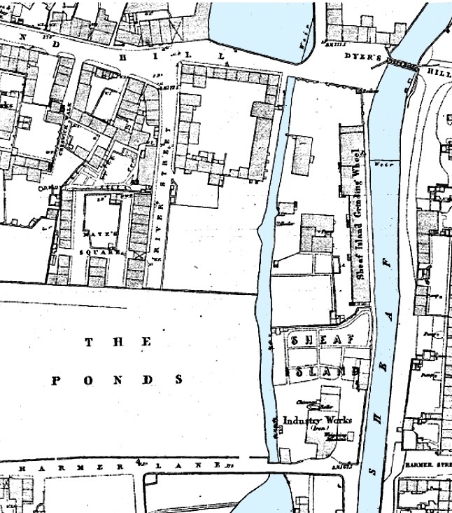
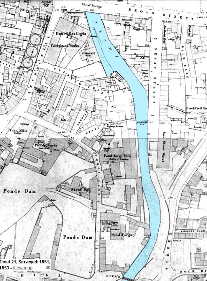
Pond Hill (Dyer's Hill), and Harmer Lane, Bedford Dam (south), Ponds Dam (north). c.1853
 2 points
 -
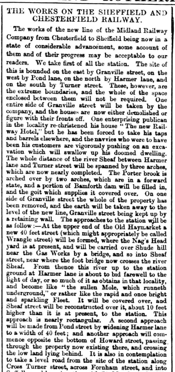
Published: May 2 1867
 2 points
 -
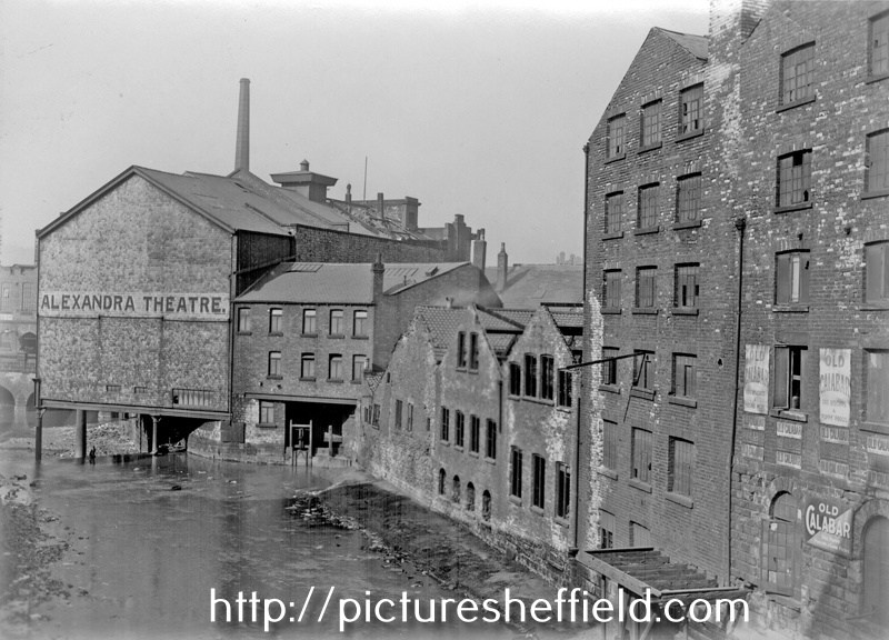
Looking towards Blonk Street Bridge
 2 points
 -
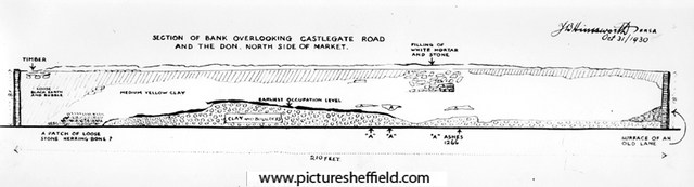
Sheffield Castle excavations recorded by J.B. Himsworth. Plan showing section of bank overlooking Castlegate Road and The Don. 31st October 1830. y00919 Taken from 'Sheffield Castle Excavations', by J.B. Himsworth, Ref: 914.274 SQ. I'm sure there's a better image somewhere.
 1 point
 -
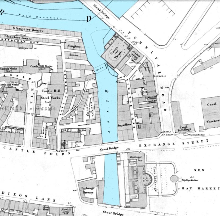
The Canal Basin measured for the Duke of Norfolk, with the line of Exchange Street plotted, [1817] https://www.picturesheffield.com/frontend.php?keywords=Ref_No_increment;EQUALS;arc04186&pos=50&action=zoom&id=104945 Marked: The Wicker, Blonk Street, Ladys Bridge, weir, River Dun [River Don], intended bridge [Blonk Bridge], Wain Gate, Town Hall, Castle Hill, Castle Street, Castle Folds, Hay Market, Tontine [Tontine Inn], Dixon Lane, Sheaf Bridge, River Sheaf [intended bridge], Broad Steet, hospitals and chapel [Shrewsbury Hospital], shuttle, warehouses, [canal] Basin, Soap House. Plan of Sheffield Castle about 1700 (1706?) drawn in the 1930s https://www.picturesheffield.com/frontend.php?keywords=Ref_No_increment;EQUALS;y09509&pos=56&action=zoom&id=64229 A plan of the House, Croft, etc. near the Hospitals held under the Duke of Norfolk by George Crook, containing in all 3a [acres], 3r [rods], 3p [perches] 1769. https://www.picturesheffield.com/frontend.php?keywords=Ref_No_increment;EQUALS;arc03384&pos=61&action=zoom&id=98620 Land between Broad Street, the River Sheaf and South Street. Crookes [Crook's] Croft, on the west bank of the Sheaf, south of the Shrewsbury Hospital; new Coal Road marked, with acreage taken for it; buildings, summer house and well; acreage of the whole. Coloured, on parchment. (Sheaf Lane, Sheaf Street, Granville Hill, South Street, Shrewsbury Hospital)1 point
-
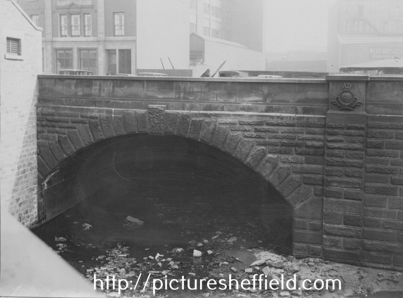
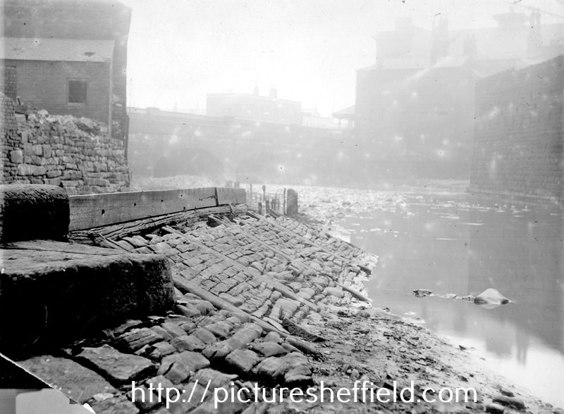
Culvert for the River Sheaf which now runs from opposite Midland Railway Station to the outfall beside Blonk Street Bridge into the River Don. 12th May 1910. https://www.picturesheffield.com/frontend.php?keywords=Ref_No_increment;EQUALS;v00925&pos=18&action=zoom&id=42717 Copyright: Jill Dalton Note the high quality triple layered brickwork which is still in place today. Left side view from Exchange Street Bridge, River Sheaf below, 1913-1914. y00270 Taken from 'Properties to be Demolished', 1913 and 1914., Cat. No. 914.274 SQ. Castlegate end of the Sheaf Culvert, built 1916 over the River Sheaf; Wilkes Brothers and Co. Ltd., ironmongers are just visible in the background (right) 6th July 1929.u04625 Photographer: City Engineers, Bridges Department.
 1 point
 -
Sheaf Bridge to Blonk Bridge
 1 point
 -
Dyer's Hill (Pond Hill) to Sheaf Bridge, c.1850 https://maps.nls.uk/geo/explore/side-by-side/
 1 point
 -
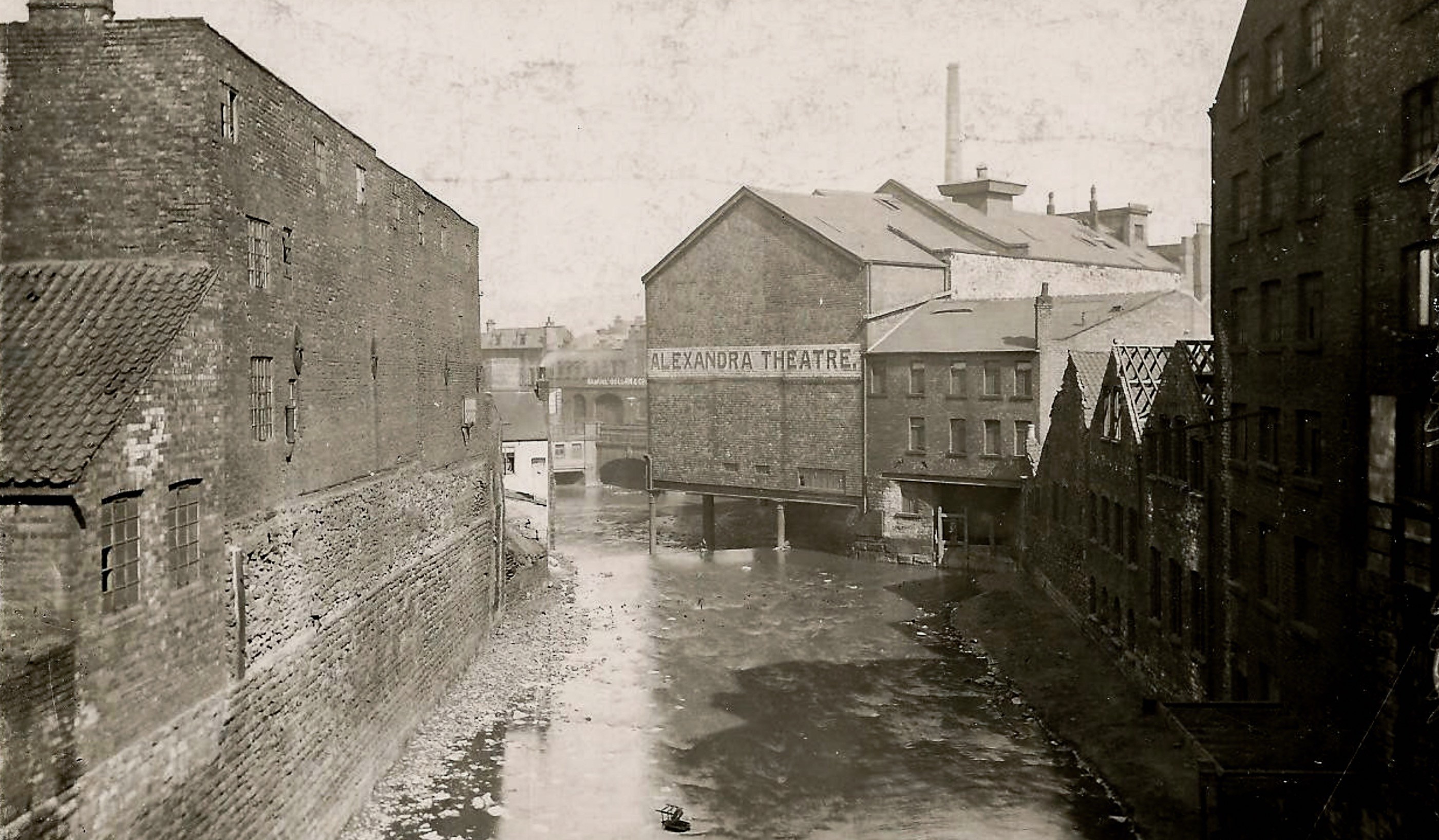
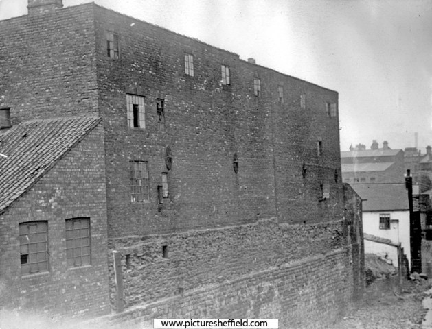
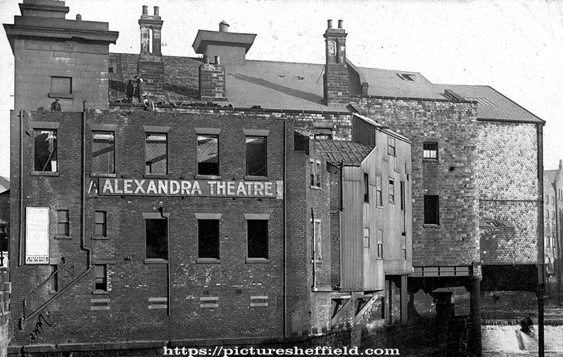
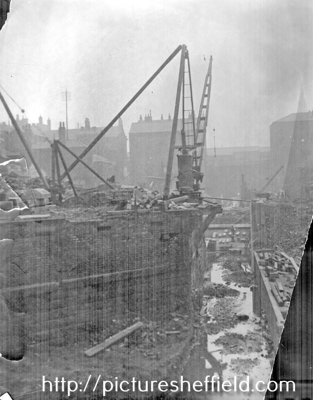
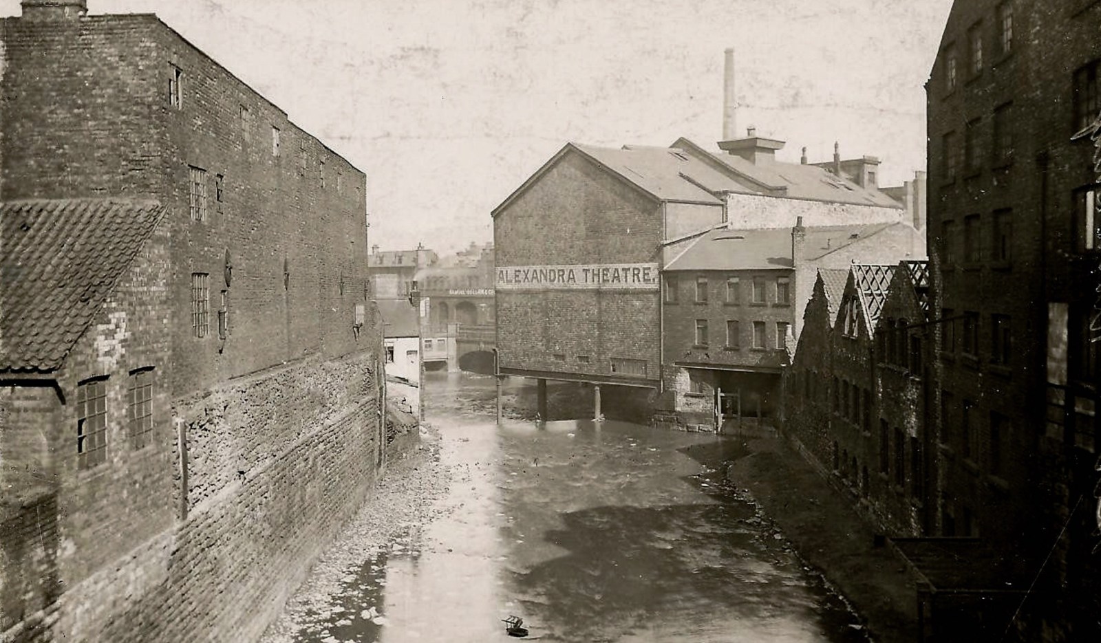
Demolition of Alexandra Theatre, Blonk Street, showing the combined flow of rivers Don and Sheaf flowing underneath. Built 1837, by Mr Egan. Originally known as The Adelphi Circus Theatre. Demolished 1914. s01597 Photograph was taken during the demolition of the theatre, which closed in 1914 For more information see 'The Lost Theatres of Sheffield', by Bryen D. Hillerby. Cat. No. 792.0942.4S. Rear of Alexandra Theatre, showing the combined flow of the rivers Don and Sheaf, from Sheaf Bridge, Exchange Street. 1909.s12204 River Don meets River Sheaf looking towards Blonk Street Bridge, Alexandra Theatre in background. u03245 River Don meets River Sheaf looking towards Blonk Street Bridge, Alexandra Theatre in background. https://www.picturesheffield.com/frontend.php?keywords=Ref_No_increment;EQUALS;v00945&pos=7&action=zoom&id=42736 Site of Alexandra Theatre, left (demolished May 1914), at the point where the River Sheaf meets the River Don, photographed from Blonk Bridge, looking towards Exchange Street Bridge. Tower in background, left, belonging to the Corn Exchange. May 1914.u03301 Alexandra Opera House, Smithfield Hotel, Victoria Hotel, Blonk Street on Ordnance Survey Map. 1890. https://www.picturesheffield.com/frontend.php?keywords=Ref_No_increment;EQUALS;y06788&pos=22&action=zoom&id=59988 OS Map 294.8.12. 1890. https://www.picturesheffield.com/frontend.php?keywords=Ref_No_increment;EQUALS;q00081&pos=30&action=zoom&id=152389
 1 point
 -
Property on the corner of Castle Folds and Broad Street, on the bank of the River Sheaf, [1821-1827] https://www.picturesheffield.com/frontend.php?keywords=Ref_No_increment;EQUALS;arc03421&pos=3&action=zoom&id=98685 The site of Castlefolds Market. Shows Dixon Lane & Hospital Bridge. Needs a bit of manipulation to view. Scanned upside down. Plan of the property on the west bank of the River Sheaf, between the Hospital bridge and the bridge leading to the Canal basin [Exchange Street], [c. 1817-1821] https://www.picturesheffield.com/frontend.php?keywords=Ref_No_increment;EQUALS;arc03420&pos=2&action=zoom&id=98683 Premises numbered and listed with tenants and yardages. Tontine Inn. (site of Castlefolds Market). Dixon Lane.1 point
-
The Canal Basin measured for the Duke of Norfolk, with the line of Exchange Street plotted, [1817] https://www.picturesheffield.com/frontend.php?keywords=Ref_No_increment;EQUALS;arc04186&pos=5&action=zoom&id=104945 Marked: The Wicker, Blonk Street, Ladys Bridge, weir, River Dun [River Don], intended bridge [Blonk Bridge], Wain Gate, Town Hall, Castle Hill, Castle Street, Castle Folds, Hay Market, Tontine [Tontine Inn], Dixon Lane, Sheaf Bridge, River Sheaf [intended bridge], Broad Steet, hospitals and chapel [Shrewsbury Hospital], shuttle, warehouses, [canal] Basin, Soap House.1 point
-
Rear of The Alexandra Theatre on Blonk Street and River Sheaf prior to culverting.
 1 point
 -
A correct plan of the town of Sheffield by William Fairbank. 1771 https://www.picturesheffield.com/frontend.php?keywords=Ref_No_increment;EQUALS;y09647&pos=7&action=zoom&id=35901 point
-
Plan of part of the town of Sheffield, comprising the site of the present and proposed corn, hay and cattle markets, also various improvements connected with the latter. 1827. https://www.picturesheffield.com/frontend.php?keywords=Ref_No_increment;EQUALS;arc04183&pos=13&action=zoom&id=104936 With illustrations of proposed Corn Exchange, elevation of the houses fronting the new Hay Market, and an elevation of the bridge over the Dun [Don]. Reference a - proposed corn exchange and office, b - erections on each side of Corn Exchange, c - weighing machine, d - row of shops. Inns in the immediate vicinity of the present Hay and Corn Markets 1 George, 2 King’s Head, 3 Angel, 4 Commercial, 5 Yellow Lion, 6 Tontine, 7 Healeys Hotel. The sites of the present Hay, Corn and Cattle markets are coloured red, and proposed are coloured blue. Other improvements are shown in yellow. Marked are: Market Place, Angel Street, Angel Inn, old corn market, King Street, post office, Change Alley, Kings Head, Fruit Market, Market Street, Norfolk Street, John Street, Commercial Inn, Hay Market, Yellow Lion, Pond Lane, Shude Hill, Fish Market, Dixon Lane, Tontine Inn, Castle Folds, Castle Hill, Healeys Hotel, Sheaf Bridge, River Sheaf, canal bridge, proposed Hay market, proposed Corn Market, Broad Street, Canal Basin, Canal Warehouse, market for fat cattle, lean cattle and milch cows, pig market, sheep market, River Dun [River Don], Willey Street, Blonck Street, Wicker, Cattle Market, Ladys Bridge, Bridge Street, Wain Gate, Town Hall, Killing Shambles and Castle Street. Plan of part of the town of Sheffield showing the existing markets, the property of His Grace the Duke of Norfolk, and the projected improvements. 1847. https://www.picturesheffield.com/frontend.php?keywords=Ref_No_increment;EQUALS;arc04187&pos=14&action=zoom&id=104946 Marked: Change Alley, Norfolk Street, Bakers Hill, Pond Lane, Market Street, Shude Hill, present Shambles, King Street, Old Hay Market, Angel Street, Post Office, Castle Street, Snig Hill, Town Hall, Waingate, Killing Shambles, Castle Hill, Castle Folds, Dixon Lane, proposed market [Norfolk Market Hall], River Sheaf, new market ground, fountain, Corn Market, Broad Street, Hay Market, Exchange Street, canal warehouse, Canal Wharf, Canal Basin, Blast Furnace Road, Sheaf Works, Wharf Street, Effingham Street, Maltravers Street, fair ground [fairground], cattle market, River Don, reservoir, Willey Street, Blonk Street, Wicker, Nursery Street, Wicker Lane, Stanley Street, Stanley Lane, Andrew Street, Johnson Street, Walker Street, Manchester Sheffield and Lincolnshire Railway, Midland Railway Station [Wicker Railway Station] and railway station [Bridgehouses Station].1 point
-
This Map shows Dixon Lane and the "Bridge" known as Hospital Bridge and the confluence of the Rivers Sheaf & Don. A map of the dams, goights and other works belonging to the Pond Forge Co together with some other intermediate properties. 1820. https://www.picturesheffield.com/frontend.php?keywords=Ref_No_increment;EQUALS;arc04213&pos=15&action=zoom&id=105197 Boardman's Bridge, wear [weir], Porter Brook, goight, River Sheaf, Upper Dam, Sheaf Lane, bridge, Upper Forge Wheel, dam, Upper Forge, Sheaf Mill, steam engine, Lower Forge, grinding wheel, arched goight, tail goight, Shude Hill, Hospital Bridge, hospitals, Sheaf Bridge, Castle Orchards Wear [weir], River Dun [River Don], Pond Street, Forge Lane, Pond Well Hill. Late Joseph Ward, John Hounsfield, Josiah Blackwell, late Abraham Wright, S. Woodcock and Sons, Joseph Blackburn, Thomas Mearbeck and Co., S. Rawson and Co. [?Thomas Rawson and Co], Joseph Shimmeld, John Vickers, Sheffield Gas Light Co., S. and S. Darwin, Sarah Beeley, Widow Beardsall, John Hale, Widow Badger, and J. B. Ward.1 point
-
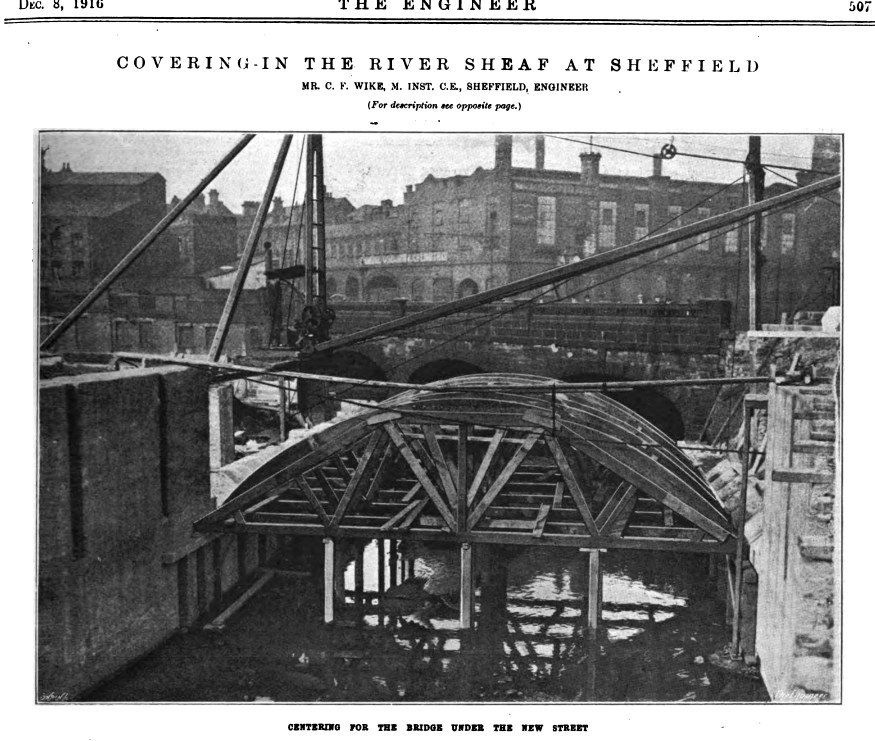
The Engineer - Volume 122 - Page 506 books.google.co.uk. Pdf file - https://www.google.co.uk/books/edition/The_Engineer1 point
-
Exchange Street to the River Don was in 1914, the upper section was culverted prior to the building of the Midland railway, and the Station which opened in 1870. Edit1 point
-
Second-Lieutenant Arthur William Fielding, York and Lancaster Regiment, 97, Farfield Road, Sheffield who was killed in action in France, 16th April 1918, after three years service.y05735 Killed aged 27. Son of Parkin and Lavina Fielding; husband of Edith Fielding, of 97 Farfield Road, Sheffield. Buried in Cambrin Military Cemetery, France. Sheffield Year Book Victory Number 1919 Page 60 (Local Studies ref. 032.74 SST) Wardsend Cemetery - memorial to Private William T. Smout, killed in action in France, 1 Jul 1916 (aged 30) Private William Thompon Smout (service No. 12/1854) served in the Yorkshire and Lancaster regiment. He is commemorated on the Thiepval Memorial (Pier and Face 14 A and 14 B), The Somme, France. He was the son of Martha Hannah Smout, of 104, Farfield Road, Neepsend and the late Edward Thompson Smout. Details of other family members are also inluded in the Stone. a00818 16th February 2013 Photographer: Peter Evans

 1 point
 -
Roger Stevenson, Hope this is the post you're looking for. 🤞 Parkwood Springs Residents 1948 https://www.sheffieldhistory.co.uk/forums/topic/2123-parkwood-springs-residents-1948/1 point