Search the Community
Showing results for 'coal pit lane'.
-
In my 1893 Kelly's it states that Jessop Lane ran from Porter Street to Sylvester Street & Arundel Street and the inhabitants at that time were as follows: NORTH SIDE No 7 George Beeley Coal Dealer No 9 Francis Howard Bricklayer No 15 Thomas Shimmel Razor Blade Forger No 25 David Hall Coal Dealer No 39 Jim Gamble Carter SOUTH SIDE No 6 William Wrightson Tailor No 44 Thomas Brigham Firewood Dealer
-
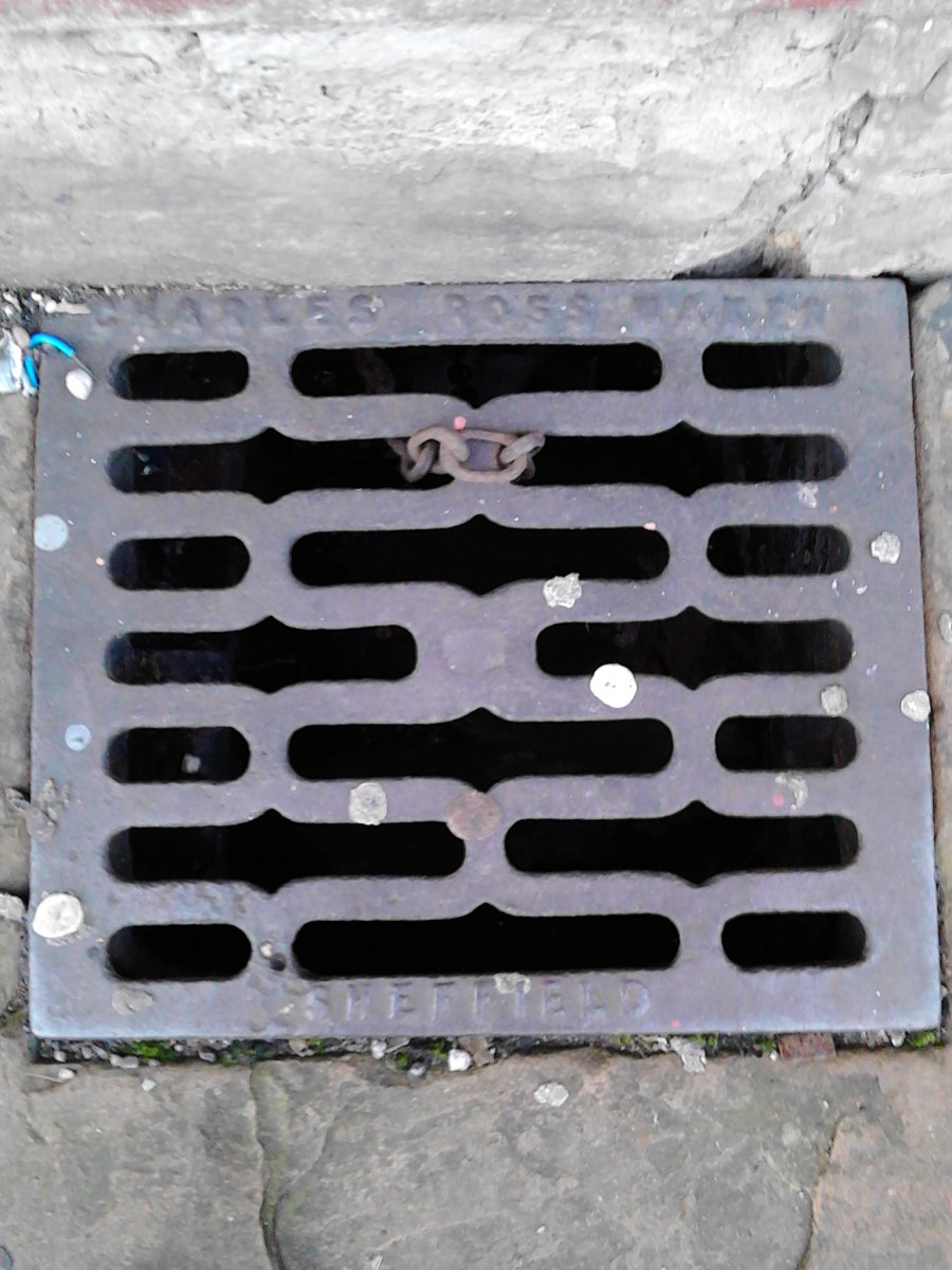
Charles Ross of Heeley already features in this thread and his"> work can be seen all over Heeley, Abbeydale and Ecclesall in particular. I recently saw a couple of his coal chute covers with name legible in the 'Lakes' area off Abbeydale Road. There are thousands of these covers about, but I have only seen a handful with the name remaining.
-

Peter Pan's Cave - Junction Colliery, Woodhouse?
RLongden replied to RLongden's topic in Sheffield History Chat
I never expected Google Street View to extend that far into the wilderness, but sure enough, Big Brother has even copped Peter Pan's..... https://www.google.com/maps/place/Woodhouse,+Sheffield,+South+Yorkshire+S13,+UK/@53.359089,-1.349987,3a,15y,221.48h,89.89t/data=!3m4!1e1!3m2!1sbHfhaxJWoNfS1pcenUurrg!2e0!4m2!3m1!1s0x48799d0a0d4b94e5:0xc95c1d6744c8be64?hl=en I don't live too far away these days and might even take a walk over one weekend - not that I'm expecting to find much other than what is shown on the photo. I do remember the yard (when it was less grassy) being full of clinker and hard black shale, which given it's heritage is not surprising? Grateful to Steve HB for the link to the 'Industrial Coal and Iron Company', who's pits were also over at Storforth Lane in Chesterfield. That will open up some additional avenues of research and handy they were a listed company, as that means public records, which tend to be more readily archived. I agree with the air raid shelter theory Unitedite Returns, as it's a substantial structure and would probably have withstood anything that Goering's flyboys could have dropped on it? However, if it was built at the same time at the pit, it pre-dated the invention of aircraft by 50 years, so either it was great forward planning, or it was adapted at a later time?! Thanks Gordon for the Grammar school memory. My mum was there and although she never knew it as the "Secco", she was able to make the link too. Back to the research..................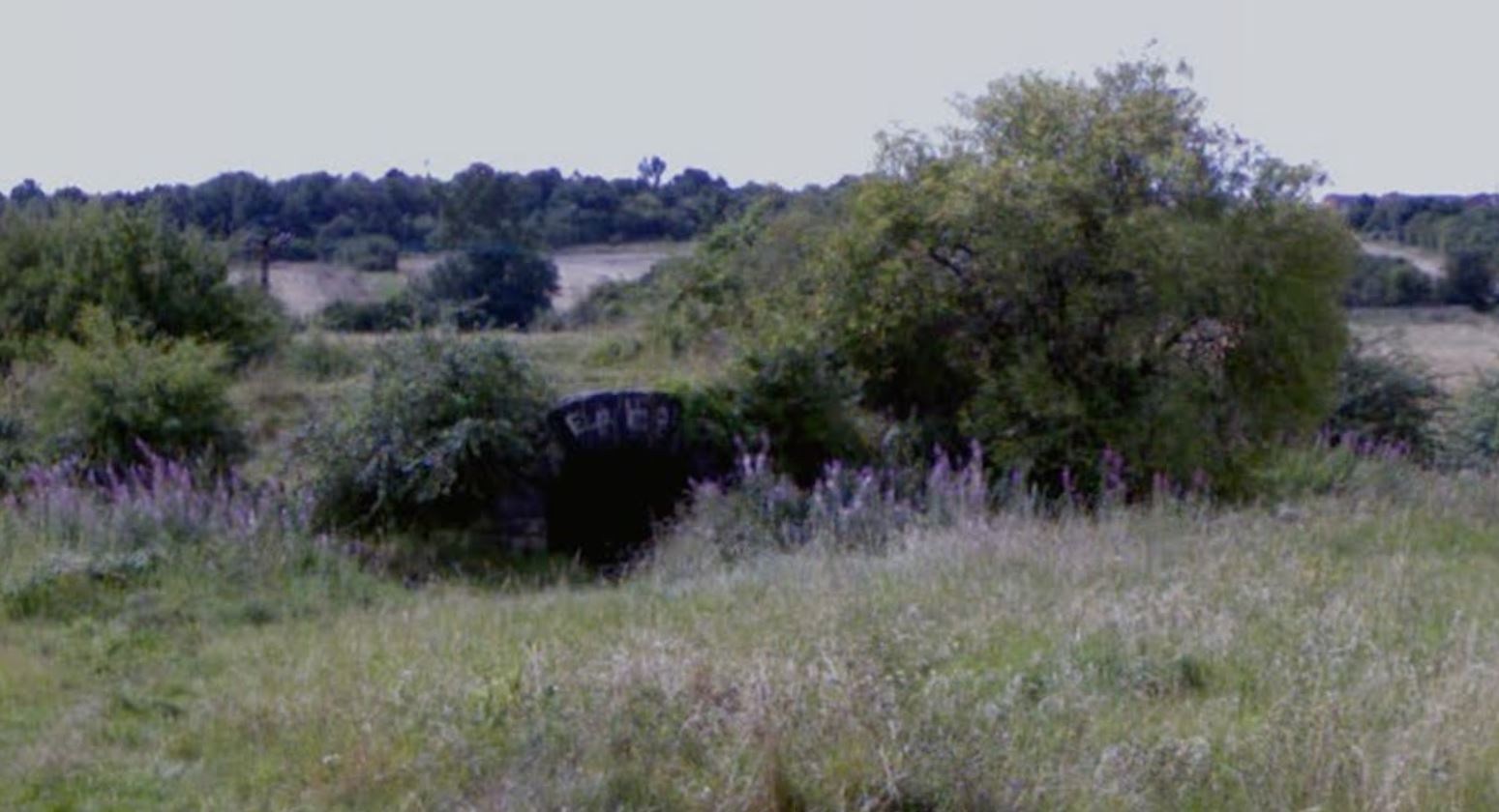
-
Peter Pan's Cave - Junction Colliery, Woodhouse?
RLongden replied to RLongden's topic in Sheffield History Chat
I never expected Google Street View to extend that far into the wilderness, but sure enough, Big Brother has even copped Peter Pan's..... https://www.google.com/maps/place/Woodhouse,+Sheffield,+South+Yorkshire+S13,+UK/@53.359089,-1.349987,3a,15y,221.48h,89.89t/data=!3m4!1e1!3m2!1sbHfhaxJWoNfS1pcenUurrg!2e0!4m2!3m1!1s0x48799d0a0d4b94e5:0xc95c1d6744c8be64?hl=en I don't live too far away these days and might even take a walk over one weekend - not that I'm expecting to find much other than what is shown on the photo. I do remember the yard (when it was less grassy) being full of clinker and hard black shale, which given it's heritage is not surprising? Grateful to Steve HB for the link to the 'Industrial Coal and Iron Company', who's pits were also over at Storforth Lane in Chesterfield. That will open up some additional avenues of research and handy they were a listed company, as that means public records, which tend to be more readily archived. I agree with the air raid shelter theory Unitedite Returns, as it's a substantial structure and would probably have withstood anything that Goering's flyboys could have dropped on it? However, if it was built at the same time at the pit, it pre-dated the invention of aircraft by 50 years, so either it was great forward planning, or it was adapted at a later time?! Thanks Gordon for the Grammar school memory. My mum was there and although she never knew it as the "Secco", she was able to make the link too. -
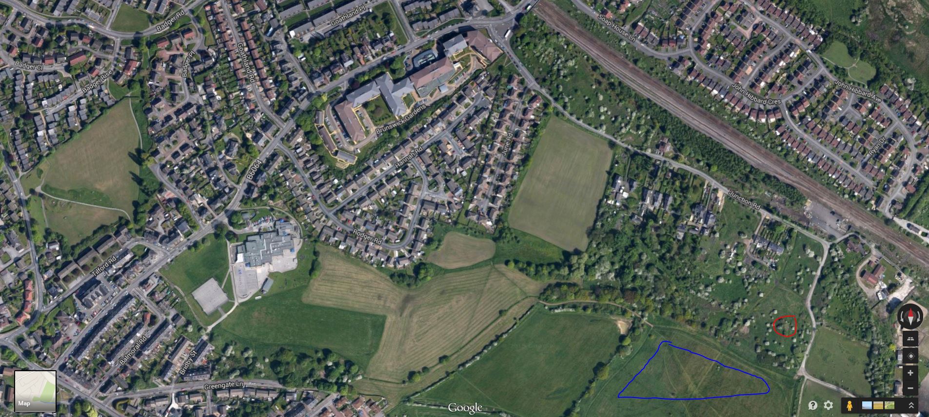
East of Woodhouse at the end of Junction Road (prev. Long Storrs Lane), on the right opposite the signal box, there is an open plot of land with what looks like a semi-submerged railway tunnel (marked in red on attached aerial view). In my 1970's childhood, it was colloquially known as 'Peter Pan's Cave' and at the time, I never gave a thought to what that 'tunnel' was, as it only ever served as a place to shelter when out playing and the heavens opened and it only went back 15-20ft before being blocked by bricks and rubble. I remember it having litter scattered around inside and the remains of countless fires, the outside arch being adorned with graffiti (some being abstract works of male and female anatomy!) If ever a place was over-romanticised with a wholly inappropriate name eh? I could never have imagined Wendy saying "Oooh Peter, I just love what you've done with the place!" I grew up on June Road, which is off the top of Junction Road almost to the end where it meets Station Road / Furnace Lane and where the old 'Grammar' school stood opposite the Junction Hotel, beside the railway station and bus terminus. The whole of the area from the bottom of Junction Road, across the 'Secco' (which was a large open playing field [blue on the aerial view], marked out with several football pitches and in my childhood had a wooden hut at it's western side - it's name I always believed was derived from being the playing fields for the Grammar school - Secondary Grammar = Secco!), up Greengate Lane (a grass footpath until it met John Calvert Road) and up past the allotments, the brick pond and across to Brunswick Middle School was one huge playground for me and my pals. Never having to cross a road and always within a few minutes of home for a drink, some food, or a plaster (and some sympathy!), countless weekends, school holidays and even on school nights in summer were spent making dens in the cornfield, climbing trees by the branch line, or scrumping in Pearson's orchard! In my teens, the 'pit yard' was a scrambling track for dirt bikes, one of the many trails that we could follow on our chopped down, chunky tyred mopeds! Anyway, being much older now and taking an interest in local history, it occurred to me that this may have had some industrial heritage and it was only when I read Ken Wain's excellent "The Coal Mining Industry of Sheffield and North East Derbyshire" (p. 47-48), I discovered that it may have been 'Junction Colliery'? The dates seem to fit Ken's book, as looking at maps of the area, it did not exist in 1850-1: http://maps.nls.uk/view/10234522 But by 1896-7, it had closed and was referred to as 'Old Colliery': http://maps.nls.uk/view/101600226 I've scoured every other source I have access to, but cannot find any further information on the colliery and wondered if anyone else had done any work to find out more? Looking at the maps in more detail, the area was scattered with collieries and shafts and it seems the immediate local area was a hive of activity. It actually appears that the row of terraced houses close by may have actually been built as 'pit cottages'? Greengate Lane used to go all the way to the pit yard and there was a tramway linking the pit to the railway line to the North. I'll keep researching, but if anyone has any information they're willing to share, it would be very gratefully received!

-
This is a great subject and there are other threads on SH about the Turnpike Roads: http://www.sheffieldhistory.co.uk/forums/index.php/topic/7948-sheffield-turnpikes-in-the-18th-century/ The Sheffield Turnpikes and their Toll Bars would be a good research topic, as virtually all the roads still exist today (with some diversions made to accommodate modern roads) and so do many of their toll bar buildings, although faded into anonymity? To answer sheffmark's question above, I believe the Round House at Ringinglow also served as a Toll Bar for two Turnpikes (or was at least the confluence of two Turnpike Roads). It was at this point that the Turnpikes for Chapel-en-le-Frith and Buxton diverged, with the Chapel route continuing westward along Ringinglow Road, whilst the Buxton Route turned southward down Houndkirk Road: http://www.picturesheffield.com/frontend.php?keywords=Ref_No_increment;EQUALS;s11624&pos=1&action=zoom&id=14590 http://www.picturesheffield.com/frontend.php?&searchterms=round_house&action=search&keywords=all%3BCONTAINS%3B%25round_house%25%3B#rowNumber1 https://www.google.co.uk/maps/@53.3494509,-1.5630957,16z?hl=en The list of Sheffield Turnpike Roads (extracted from the thread posted by Bayleaf above): The list of turnpikes that follows includes the main routes and ignores connecting lanes, and is confined to the period earlier than 1820. The roads are arranged in chronological order of the Acts of Parliament which sanctioned their turnpiking or construction. Of such Acts there are some twenty-two passed between 1739 and 1818 dealing with turnpike undertakings directly affecting the main roads through Sheffield, and not counting the numerous Acts for the enlargement or modification of original schemes. 1. SHEFFIELD-DERBY. Sheffield and Derby, or Duffield Trust. Turnpiked by an Act of 1756. The original route was London Road, across Meersbrook Park, Derbyshire Lane, across Graves Park, Little Norton, near Coal Aston, to Unstone, Whittington Hill and Whittington Moor to Chesterfield. In 1795 the route was altered to avoid the steep pull up Derbyshire Lane, Coal Aston and Whittington Moor. The new line followed the modern route in general. In 1825 a short diversion was made in order to take the road on its present line past Meadow Head. 2. SHEFFIELD-BUXTON, AND -CHAPEL. Sheffield-Buxton and Sheffield-Chapel-en-le-Frith Joint Trusts, 1758. These roads went to Ringinglow Toll Bar together, by way of Sheffield Moor, Highfields, Sharrow Lane, Psalter Lane and Ringinglow Road. At that point they diverged. The Chapel Branch went over the Cupola to Hathersage, thence to Castleton by the modern line, and then up the Winnats to Sparrowpit and Chapel. The other branch went along Ankirk (or Houndkirk) Road to Fox House, down to Grindleford, up the Sir William, through Hucklow and Tideswell to Buxton. A diversion was made to avoid the Sir William in 1795 by way of Calver and Stoney Middleton. The modern route to Fox House from Ecclesall via Dore Moor was made in 1812. 3. SHEFFIELD-WAKEFIELD. Sheffield and Wakefield Trust. Turnpiked by an Act of 1758. This road followed the ancient route—Nursery, Bridgehouses, Pye Bank, Pitsmoor, to Chapeltown and Barnsley. Diversions were made via Spital Hill and Burngreave in 1835-6. Drake, writing in 1840 about the new Railway Station in Sheffield (at the Wicker), says: Along the high ground on the left runs the new road to Barnsley. It gradually declines away from the railway in the direction of the old road with which it forms a junction at Pitsmoor Bar. The design of ijs formation was to avoid the tremendous ascent of Pye Bank, which all who have ever left Sheffield by the north road will not fail to remember. [32] An interesting comment on the state of this road is made in 1829 by James Mills, a surveyor. He writes : "I cannot doubt that the Trustees of this road . . . will no longer tolerate the existence of the barbarous declivities which disgrace the present Turnpike Road between Sheffield and Barnsley, to the manifest injury of both towns and the general commerce of the country . . . "(He speaks of the)" substitution of a good line of road for an incorrigibly bad one, for it is notorious that the Inns of Sheffield prefer sending their posting by way of Doncaster to avoid the hills on the present Road . . ," [33] 4. SHEFFIELD-BAWTRY. Sheffield-Bawtry Trust, 1759. This is the road which leads off the Rotherham Road just beyond the Canal Bridge. The Tinsley section followed the present route from the Wicker with the exception of a loop up Spital Hill and to Hall Carr, which was straightened out in 1806. 5. SHEFFIELD-WORKSOP. Attercliffe-Worksop Trust, 1764. This road diverged from the Tinsley Road at Attercliffe, and went by Worksop Road and Darnall to Handsworth and Aston. 6. SHEFFIELD-BASLOW. This road is a combination of several roads. The section between Barbrook Mill and Baslow was part of the Chesterfield-Hernstone Lane Head (Tideswell) Trust which was continued by an Act of 1759. The section from Owler Bar to Totley was part of the Greenhill Moor-Hathersage Trust created by an Act of 1781. An Act for making the road between the end of Sharrow Lane and Totley (i.e., Abbeydale Road) was passed in 1802, though the road was not completed till 1821. At this last date the whole road between Sheffield and Baslow was transferred to the care of the Greenhill-Hathersage Trust. The route followed was the modern one. 7. SHEFFIELD-DONCASTER. Tinsley-Doncaster Trust, 1764. This road joined the Sheffield-Tinsley road at Bawtry Road. It lay almost exactly on the present route. Its maintenance was a matter of concern to the proprietors of the River Dun Company as it led to that point to which the river had been made navigable. 8. SHEFFIELD-PENISTONE-HALIFAX. Sheffield and Halifax Trust, Penistone Division, 1777. This road led from Shalesmoor along the modern line with the exception of a section which ran through Greno Wood and which the local folk still call "the old coach road." It was diverted through Parson Cross and Barnes Green in 1826. 9. SHEFFIELD-MANSFIELD. Sheffield-Gander Lane Trust. Turnpiked by an Act of 1779. The route was the modern one—City Road, Intake, Mosbrough, Eckington, Barlborough at Gander Lane and so to Mansfield. 10. SHEFFIELD-FROGGATT. Greenhill Moor-Hathersage Trust, created 1781. This road went from Greenhill cross-roads via Bradway, Dronfield Woodhouse and Holmesfield to Owler Bar, and then across the moors to the top of Froggatt Edge. It crossed the slope apparently just above the line of railway at Grindleford Station to Hathersage Booth, where it turned sharply down the hill to Hazelford and so to Hathersage. The southern exit from Hathersage led through Hazelford above the line of wood on the other side of the river until it joined the Sir William. This route was altered to the present line through Fall Cliffe Wood to Grindleford in 1825. A branch of the Greenhill-Hathersage road was provided in 1781 from Totley to Stoney Middleton—the modern road down Froggatt Edge. 11. SHEFFIELD-LANGSETT. Wadsley-Langsett Trust, 1805. At this date the road diverged from the Sheffield-Penistone Road at Catchbar Lane. The new road was an extension to the end of Penistone Road near St. Philip's Church, and was made between 1837 and 1840. It followed the modern line through Middlewood, Oughtibridge and Stocksbridge—called by Fairbank "a beautiful and romantic valley." Over the section from Shalesmoor to the bridge at Holme Lane, Fairbank was engaged in litigation in order to get paid for his services. 12. SHEFFIELD-GLOSSOP. Sheffield-Glossop Trust. Turnpiked by an Act of 1818 and opened for traffic in 1821. Much was hoped for from this road, as it led more directly to Manchester. It was a very expensive undertaking because of the gradients, and the Dukes of Norfolk and Devonshire contributed heavily. The route is the modern one—Crosspool, Rivelin, Moscar and the Snake. A branch was made from Moscar to Langsett—Mortimer's Road. The foregoing list of new and reorganised routes and roads represents great enterprise and expenditure. Their effect is to be seen in the considerable use of them and in the stimulus thus given to Sheffield industry. Their efficiency is to be observed in the speeding up of transport. This may be illustrated by the times of the coach journeys. When Samuel Glanville of the "Angel" optimistically advertised in 1760 liis intention to run a coach to London, he concluded his announcement with this sentence— "Performed, if God permit, by John Handforth, etc. . . ." The trip took three days. In 1787 the same journey was done in twenty-six hours, and the last Sheffield Mail did the distance in sixteen hours. The earliest Mail Coaches travelled at six miles an hour, but the speed was increased to twelve in their heyday. In 1836, thirteen coaches were advertised to leave "The Tontine" and "The King's Head" daily. The coaches and the new Turnpikes were doomed as soon as the North Midland Railway was brought past and northwards of Sheffield.
-

Northern Avenue Shopping Centre Arbourthorne
DaveH replied to DaveH's topic in Sheffield History Chat
As a kid living in the prefabs on Algar Place you could go out of our back garden straight onto Arbourthorne playing field. I would run down the level part of the playing field to where the embankment fell away steeply towards Norfolk Park and stay there just to take in the view, - the farmland, the pond, the horses in the field and the park entrance. On a clear day (pre clean air act days, and we all used coal to heat our homes in those days) you could see the city centre and the town hall beyond, - what a view. On a number od occasions we would venture down the hill, through the farmland to the park to play on the swings, roundabout and rocking horse just inside Norfolk Park to the right of the Arbourthorne Cottages entrance, and with the café to the left. However at that time, that wasn't just "playing out on the field" to us, it was such a walk that we considered it a day out. We usually went as a group of kids, out of sight or contact with our parents for hours and as you said, in those days all considered perfectly safe and ni harm ever came to us. In fact, after the 1962 gale the wrecks of the damaged prefabs became our playground where we could play, hide and make dens. The wrecked prefabs were in a dangerous state, but again no harm ever came to us and our parents knew we were playing "in the ruins". I don't think they minded that much because when they were the same age they had played in houses destroyed by bombing in the blitz. -

Northern Avenue Shopping Centre Arbourthorne
SteveHB replied to DaveH's topic in Sheffield History Chat
Definitely tomato plants Dave, and a fair few, I took some of the green tomatoes home one day after school, but they wouldn't ripen, the burning tip at top of Spring Lane contained more than coal dust. -
Northern Avenue Shopping Centre Arbourthorne
DaveH replied to DaveH's topic in Sheffield History Chat
Yes Dave that area was also previously a mine hence the coal, not the same area I was talking about area (Brimmersfield CLOSE / ROAD??). But I am aware of it. In the 60s and 70s a kid in our year called Keith something or other (memory fails me) lived in the "flats" that were built on this area. I think I have put some pictures of this area, the different looking houses which I thought were old folks homes and the flats / maisonette type buildings behind earlier in this topic, or possibly a similar related one. Your post has cleared up some confusion about why this housing is different from the standard late 1930s Arbourthorne housing. So was the black hills between Craddock Road and Algar Crescent built on in the 1950s? -

Northern Avenue Shopping Centre Arbourthorne
DaveThursby replied to DaveH's topic in Sheffield History Chat
When I lived at 74 Eastern Avenue in the 50's, the area off Brimmesfield Road was referred to by us local kids as the Black Hills, there may have been another one behind the Travellers. I remember walking home from Craddock Road infants school and watching the Sheffield Public Works Dept (SPWD) building the houses which is why they are newer and sort of out of character with the housing in the area i.e. Arbourthorne in general. Before they built on there, my mother always knew when I'd been on the black his because I was black with the coal dust. Can't think really why they didn't build on it at the time that Arbourthorne was built before the war. I had a friend called Gayle Clarke who lived on Algar Crescent and their rear garden backed onto the black hills and before the houses were built used to sometimes, with her, walk from Brimmesfield Road to her back garden. A girl in my class was Connie White who lived on Craddock Road and her garden backed onto the back hills as did Anne Worral's who lived on Brimmesfield Road to the right of that area. -
Northern Avenue Shopping Centre Arbourthorne
DaveH replied to DaveH's topic in Sheffield History Chat
The black hills were the slag waste from Deep Pits coal pit on the other side of City road behind the Travellers Rest, the area of land between Brimmesfield Close and the quarry (where the Captive Queen was built just outside Norfolk park, which is currently a football field was once the "smouldering tip" as it was always hot underfoot and regularly caught fire due to marsh gas / firedamp (technically methane gas) from the old coal workings. -
Northern Avenue Shopping Centre Arbourthorne
DaveH replied to DaveH's topic in Sheffield History Chat
I lived in the prefabs on the Algars (Algar Place, Close and Drive) on the opposite side of Eastern Avenue to the Erringtons. We suffered similarly in the 62 gales but being lower down the hill our house survived and we stayed there until November 1965 before being rehoused. Our next door neighbours the Twiggs were also interviewed by Mike Scott and Bill Grundy for TV (scene at 6:30 news), their house wasn't badly damaged either but did have some. They were rehoused almost immediately as their father was disabled, having a blue Invacar his prefab was the only one with a garage in the back garden as well as the Anderson shelter converted to a coal bunker. There is a whole topic on Sheffield History about the Sheffield gale to which I have been a major contributor. If you haven't seen it already you may want to take a look and possibly contribute to it. I have linked / posted a Pathe Newsreel film a section of which covers damage to the prefabs on the Erringtons, - take a look, you may recognise someone. The link to this topic is here http://www.sheffieldhistory.co.uk/forums/index.php/topic/496-the-great-sheffield-gale-1962/?hl=gale -
Northern Avenue Shopping Centre Arbourthorne
DaveThursby replied to DaveH's topic in Sheffield History Chat
By the way, the houses on Brimmesfield Close are built on an area we used to call the Black Hills. It was either the site of old coal mine workings or the slag heap left over but I remember it being built upon in around 1956-1957. -
Northern Avenue Shopping Centre Arbourthorne
DaveThursby replied to DaveH's topic in Sheffield History Chat
Yes Dave, their prefab could be reached by going round the back of the Arbourthorne Hotel and down a little grassy slope to a gate at the left hand side of the "field". You went through the iron gate and walked left across Errington Crescent at about 45 degrees - their surname was Thorpe. Their neighbour were the Duckers, John Ducker I recall. The Tingle's lived over the back of my cousins on a road I cannot recall the name of. Actually, my cousins prefab was quite nice, it even had a built in fridge in the kitchen, in fact I think they all did, reminded me of an American home for some reason. Their fire wasn't open but reminded me of a woodburner which had doors with little glass panes in but like most families then, they burned coal. I can remember the coal fire smoke from everyone's fire swirling down the road which characterised that area with the lower level of the prefab roofs. Their prefab was made uninhabitable in 1962 and so they were rehoused.My auntie Joyce was interviewed by Bill Grundy for Granada TV after their prefab's roof was damaged in the February 1962 gale. Shame really, there was a good community on Errington Crescent with much pride with both people's homes and their gardens. -
Sounds promising - link to a Coal Ole Spotters photos here: Coal Hole Covers
-
Coal chute cover?
-
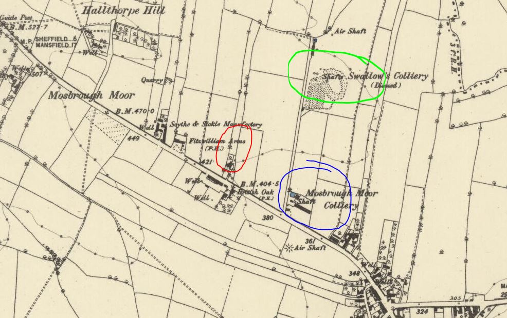
It may have been mentioned before, or elsewhere, but I didn't realise there were actually three collieries, rather than just two in that immediate area on Mosboro' Moor? Looking at the 1875-82 map of the area, at that time there were Swallow's Colliery (disused), Mosborough Moor Colliery (active) and Moorside Colliery (not even established). http://maps.nls.uk/view/101600256 Mosborough Moor Colliery looks to have been in the area adjacent to the path between Swallow's Colliery and the road, now where No.158 and the houses to the right now stand? https://www.google.com/maps/@53.328546,-1.36755,3a,90y,41.09h,81.89t/data=!3m4!1e1!3m2!1sf6zI88u6bmdk1SMBtdWnhA!2e0?hl=en Maybe those big locked gates with the concrete blocks in front are keeping people away from something? The path to where Swallow's used to be is just to the left, but interesting to note that the gardens stop short of this fenced off area. Maybe the old shaft of Mosborough Moor Colliery? Looks about the right place? Might be worth a trip out for a peek? If you look at the map in and around Mosborough and note all the annotations for all the collieries, old coal pits and shafts, the whole area must have been an absolute rabbit warren? (not including the actual one, shown south of Waterthorpe Farm! )

-
Application to open Eckington Coal Mine, after reserves at Moorside were exhausted. Interesting to note reference to Moorside Colliery on middle of page 3 and close date at bottom in note 6iii of 31/03/1992? Eckington Colliery_Moorside Mining - Application Form.pdf
-
Emailed the Coal Authority to see if they have any information on this, capping dates etc... Hopefully in next couple of months I'm hoping to get a PDF done with all the locations, a bit of history and photos of the areas as they are today. Given they are fairly close I could even plot a round walk?!
-
Yes, I've spoken to the farmer who owns the fields behind, he told me the coal authority had re filled a shaft in about 10 years ago that he had reopened with the plough! The spoil heap is now a small thicket, I should imagine the shafts are regularly inspected however?
-
I believe the other shaft for Moor Hole Colliery is in the woods (yellow star), along the path from the first capped shaft you found (red star)? I also remember reading somewhere that there was a pit on High Lane, opposite the Phoenix Inn and Farm buildings, which used to supply coal to the Phoenix Forge. There is some evidence of some structures at that point on the road, as I've had a passing glance whilst driving past. Photo is marked (red star) between the farmed fields at the point it was most likely to have been. So, marking the points of all the pits, collieries, mines, whatever they were called just in that small area, that's five... and I'm sure others will know of more, even before widening the reference area? There are several down into Mosborough, more the other way towards Manor Top, more still up into Birley and Woodhouse, Beighton and beyond. If it's just that particular area you're wanting to plot the shafts for, that's as many as I know of, off the cuff that is... Moor Hole Colliery.tiff High Lane Colliery.tiff Moor Hole_High Lane Collieries.tiff
-
Boris Barker here. My family were the caretakers here from 1976 to 1979, when we had to move out as it was being knocked down as part of the redevelopment. We lived in the house on the right: rent free but no central heating, no bathroom. We had an outside toilet (whitewashed walls) and we had to drag the tin bath in to the kitchen every week in front of the coal fire and bath Dad first, then Mom, older sister, me, then two younger sisters. No visitors allowed at this time. Ah Saturday's we had to clean the front area in front of the chapel of all the pigeon-crap (I was into skateboarding and so helped as it meant I could skate there.
-
From Sheffield Daily Telegraph 21st June 1898: SALE This Day Re John Woodhouse Deceased Lot 1 Freehold at Walkley - 4 stone built dwelling houses 62 Highton Street, 1, 2, 3, Court 2 Highton Street Lot 2 Freehold at Gleadless (farm) Lot 3 Leasehold - Travellers Rest 667 Intake Road, in occupation of Mr Henry Hepplestone, also house 585 Intake Road and fifteen houses and outbuildings 2, 3, 4, 5, 6, 7, 8, 9, 10, 11, 12, 13, 14, 15, 17 Court 11 Intake Road Lot 4 Leasehold Manor Lane eight houses 49,50, 51, 52, 53, 54, 55, 56 Manor Lane From Sheffield Daily Telegraph 24th June 1898: The will of Mr John Woodhouse, Deep Pits, Sheffield, who died on March 6 last , is proved by the surviving executor Mr Henry Hepplestone, Intake Road, Sheffield, by whom the testator's estate is sworn at £3,295 14s of which £2,067 16s 7d is net personalty Henry Hepplestone was John Woodhouse's son, and was living at the Traveller's Rest at the 1891census. Arthur Murfin and his wife Agnes were at the Travellers Rest at the 1901 census (with son Frank). They were still there in 1911, with the addition of Beatrice Alice Kay (his step daughter). From the Sheffield Evening Telegraph 30th March 1912: (a correction regarding Arbourthorne Outcrop Coal Workings): "Mr Arthur Murfin of the Travellers Rest, Deep Pits, and the miners in the district, must be credited with the successful arrangements with the Duke of Norfolk's agent to work the seam of coal prior to its being closed. Arthur Murfin died in 1943, his wife died at the Travellers Rest in 1941
-
Annie Fox, (coal dealer). 329, Langsett Road, Sheffield Whites 1905 Also, it appears that it isn't/wasn't a gatehouse. According to Picture Sheffield it was a toll bar.
-
When I first say this third picture http://www.picturesheffield.com/frontend.php?action=zoomWindow&keywords=Ref_No_increment;EQUALS;u07920&prevUrl= it really took me back a bit as it is the only picture I have seen which shows our house(or at least part of it)during the immediate aftermath of the gale. The photo is taken from the back garden of one of those 2 completely destroyed houses in the previous post picture and looks out across Algar Place and up to Northern avenue. The foreground shows an isolated patch of Arbourthorne Playing Fields that ran between the two Algars, - it was not good grass and was rocky and covered in mining slag and loose opencast shale like coal. Notice the debris scattered across it, - most of these are pieces of prefab, particularly pieces of heavy roofing material which has blown off. The closest row of prefabs are on Algar Place, the one extreme left of picture, with just 2 windows showing, is our house, 13 Algar Place. Look at the direction that roofing debris is blowing, - straight towards our house!!! Now look at that very flimsly back garden fence of ours, - wooden strips held together with chicken wire. A large piece of roof from a house on Algar Drive hit our fence and amazingly the fence, although it collapsed, held the roof back and prevented it from coming smashing straight into our house. Had it done so, it would have hit the back bedroom, and given the time it happened, I would have been in bed. Next door to us and very prominent is Mr Twigg's house, 11 Algar Place, easily identified because Mr Twigg was an invalid and had a little blue Invacar to get around, as such he had the only prefab on the estate with a garage. Our side of the street, the odd numbers, being low down, survived very well, - but look at the houses facing us on the other side of the road and up the hill, roofs missing, rooms missing, bits of debris and furniture everywhere, this is exactly the scene that greeted our eyes as we looked out of our window and daylight dawned on that eventful day, - now almost 53 years ago, - but exactly as I remember it. The prefabs on Northern Avenue are very extensively damaged and there are many pictures of them in both The Star archive (most recently in The Retro) and the BBC panorama special. They all show the damage from Northern Avenue looking down to the Algars, - how different to see the view then from the Algars up to Northern Avenue. The gap in the brick built houses on Northern Avenue is its junction with Craddock Road. This will probably be another picture I will have to buy a copy of.