Search the Community
Showing results for 'coal pit lane'.
-
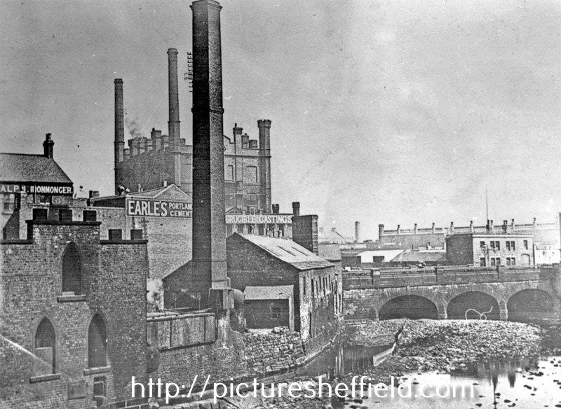
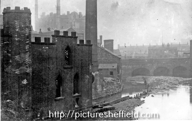
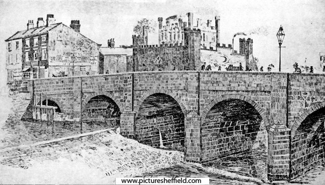
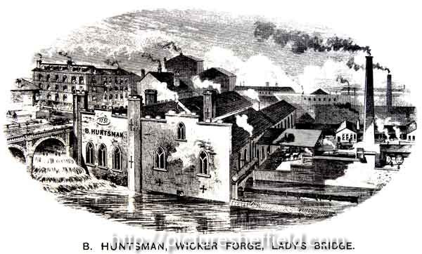
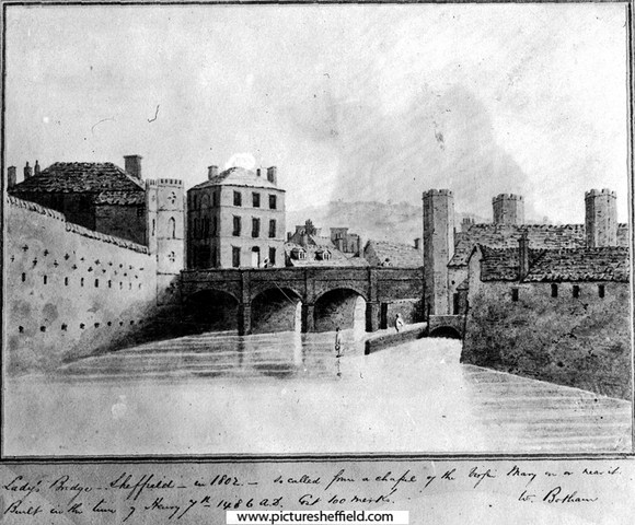
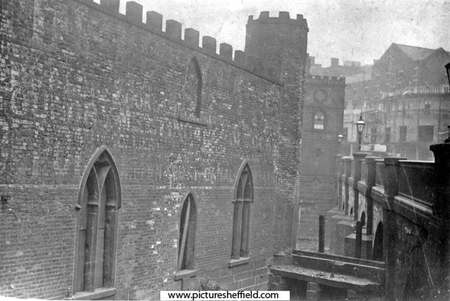
Rentals of the Wicker Wheel start 1581 in Norfolk Estate Rentals, Nether End let to William Newboulde, South End John Beighton. 1604.William Sanders and Thomas Beighton. 1639 & 1641. Smedley and Birley. 1650.William Birley, John Stainforth and William Homer. 1664 & 1670. Birley half the wheel, other half shared by Stainforth and William Stacey. Good records of repairs, notably to the Wicker Weir for which a temporary dam had been constructed in the early c18th while tenanted by Joseph then Mary Webster. 1716. New lease to cutler Benjamin Pearson had the requirement to improve the race, forebay and wheel pit with newly quarried stone. Shown on Goslings 1736 map of Sheffield. Under Pearson tenancy it remained a grinding wheel. 1737. Development by Wilson the successor of Pearson developed two Tilt Forges. 1746. Wicker Wheel is named, but 1748 a nominal rent of 5/- paid for Wicker Tilt indicating a possible expansion on going. 1752. Joseph Wilson a new lease including the Wicker Tilt added to the Wheel & Tilt at Lady's Bridge. The two sites are separted on maps, with the goit to the wheel shown behind buildings on the south east frontage of the Wicker. Information from: "Water Power on the Sheffield Rivers." edited by David Crossley with Jean Cass, Neville Flavell & Colin Turner. 1785. leased to Blonk & Co and again named in the 1794 list. Plan of B. Blonk and Co's Wheel in Castle Orchards, [Furnival Road], 1787 https://www.picturesheffield.com/frontend.php?keywords=Ref_No_increment;EQUALS;arc04189&pos=806&action=zoom&id=104959 Marked: River Dunn [River Don], The Dam, the wash, River Sheaf (with bridge), old dam, goight, etc. A map of the parcels of ground demised by the Duke of Norfolk to John Eyres. 1789. Corner of the Wicker and Blonk Street, showing part of Lady's Bridge. Also marked, Wicker Tilt Yard. https://www.picturesheffield.com/frontend.php?keywords=Ref_No_increment;EQUALS;arc03443&pos=230&action=zoom&id=98715 Lady's Bridge in 1802, Wicker Tilt (right) The name Lady's Bridge was derived from a small chapel, dedicated to Our Lady, which formerly stood at the west end of the bridge under the wall of the castle.s07499 Text reads: "Lady's Bridge Sheffield in 1802; so called from a chapel of the Virgin Mary on or near it. Built in the time of Henry VIIth 1486 A.D." 1810. Blonk, purchased the Tilts from the Norfolk Estate, recorded in Rate Books and Directories until 1871. Blonk Wheel, and ground and premises held therewith. 1834. https://www.picturesheffield.com/frontend.php?keywords=Ref_No_increment;EQUALS;arc04190&pos=7&action=zoom&id=104960 Marked: River Dun [River Don], River Sheaf (with bridge), new line of goit arched over, new cattle market, canal basin, reservoir, Blonk Wheel, weir [and Effingham Street]. Artists Impression of Lady's Bridge, Wicker, Tower Grinding Wheel in background, Wicker Tilt in foreground. 1844s07500 Henry H. Earl (Etcher) Presented to the Cutlers Company by C.D. Pettinger ESQ. April 1918. 1849. Tennants were Cocker Brothers and still 36 troughs at the grinding wheel. After a period of heavy rain resulting in the bursting of the Dale Dyke Dam at Bradfield, over the night of 11th-12th March 1864 the torrent of water gushed down the River Loxley and into the River Don resulting in much loss of life and devastation to properties. Extract from "The Great Flood at Sheffield." "When the flood was at its height the scene on the Lady’s Bridge at the top of the Wicker was most extraordinary. The water came rushing down between the buildings on each side with a force that made the Lady’s Bridge quake and tremble. Against the bridge were piled up trees, logs of timber, broken furniture, and debris of every description. The light from street gas lamps revealed to spectators, of whom they were a good many, some of the horrors of the scene. The arches of the bridge were nearly choked by the accumulation of rubbish, and the impeded waters rose to a fearful height, breaking over the parapets of the bridge, and rushing across Mr. White’s slate yard over the broad thoroughfare of the Wicker. Here might be discerned a man in a state of nudity, and who had been swept down by the flood, clinging to a lamp post in order to avoid being carried away, and there he perished, as much from the benumbing influence of the cold as from the effects of the water. In the Wicker the shutters of many of the shops were washed down, the doors burst open, and the contents of the shops carried away or destroyed. The losses sustained by many tradesmen here were very serious. In Blonk Street the flood deposited several dead bodies, as well as a vast heap of timber and broken rubbish. The wall at one end of Blonk Bridge was knocked down, together with a portion of the enclosed Cattle Market. The Wicker Tilt was submerged to a great height, and the Killing Shambles across the river were filled with water. Much injury was done at the Tower Wheel, and also at the Hartford Steel Works." The extent of the damage done is evident in the Sheffield Flood Claims some naming employees and giving details of contents of the premises. (claim included for Cockers, Wire Mill, Nursery Street) Wards Blonk & Co. Benjamin Huntsman, Francis Huntsman, Sarah Rimington, Proprietors of Wicker Tilt, Wicker, Sheffield. https://sheffieldfloodclaimsarchive.shu.ac.uk/claimSummary.cfm?claim=3-3294 James Cocker, merchant and steel refiner and manufacturer of cast steel wire etc., for Water Wheel House repairing & damages done by the Inundation of the Works of the Claimant situate in Blonk Street. (includes named employees) https://sheffieldfloodclaimsarchive.shu.ac.uk/claimSummary.cfm?claim=5-4828 The Engine damage resulted in Cocker Brothers claiming 3 weeks loss of wages for the following named workmen, although the claim eventually dismissed. https://sheffieldfloodclaimsarchive.shu.ac.uk/claimSummary.cfm?claim=1-343 A claim by Thomas Tildes Cocker and Samuel Cocker, trading in Co-partnership under the firm of Cocker Brothers, manufacturers of steel, files, wire etc. and general merchants, Nursery Street, Sheffield for damage at the works and loss of employees and wages. https://sheffieldfloodclaimsarchive.shu.ac.uk/claimSummary.cfm?claim=5-4676 Edmund Cocker, Wire Drawer of 117 Nottingham Street, Sheffield. https://sheffieldfloodclaimsarchive.shu.ac.uk/claimSummary.cfm?claim=10-918 George Morton, wire drawer at Cocker Brothers, Nursery Street Wire Mill of 45 Nottingham Street. https://sheffieldfloodclaimsarchive.shu.ac.uk/claimSummary.cfm?claim=1-87 Thomas Cocker, wire drawer. Howard Hill, Steel Bank, Sheffield for loss of wages at the works of James Cocker, Blonk Street. (claim withdrawn) https://sheffieldfloodclaimsarchive.shu.ac.uk/claimSummary.cfm?claim=1-921 Jonathan Wilson, wheelwright, Blonk Street, Sheffield. https://sheffieldfloodclaimsarchive.shu.ac.uk/claimSummary.cfm?claim=5-4652 1870's Wire Mill had been built although the head and fall of the wheel was still entered in the Rate book of 1871, James Cocker still using water power, confirmed in the 1874 & 1895 lists. B. Huntsman, Wicker Forge, Lady's Bridge. y13250 Image from Illustrated Guide to Sheffield by Pawson and Brailsford, p.133, 1889. O. S Map 1890, including Naylor, Vickers and Co., Millsands Steelworks, Exchange Brewery, Wicker Tilt, etc., Lady's Bridge https://www.picturesheffield.com/frontend.php?keywords=Ref_No_increment;EQUALS;y06791&pos=11&action=zoom&id=59986 1895. Vickers are recorded drawing wire using a low breast wheel. The tilts tenanted by Huntsman had no head and fall recorded; indicating steam in use. Confirmed by recording an ancient and obsolete wheel. Water was taken from the Weir at Lady's Bridge. The Tilt and Wheel sites have been built over. Lady's Bridge and Wicker Tilt (Huntsman's Forge), No. 2, Wicker, before 1901, occupied by Benjamin Huntsman, owned by Ward, Blonk and Co. steel tilters and forgers. It was demolished in 1901. s07493 River Don from Lady's Bridge, No 2, Wicker, Wicker Tilt also known as Huntsman's Forge, occupied by Benjamin Huntsman and previously by Blonk and Co., foreground, left. Blonk Street Bridge in near distance, Tower Grinding Wheel in background. 1896. s12220 s12219 Building construction at the side of the River Don between Lady's Bridge and Blonk Street This building was occupied by Hancock and Lant from the 1950s. https://www.picturesheffield.com/frontend.php?keywords=Ref_No_increment;EQUALS;s10087&pos=5&action=zoom&id=13247 https://www.picturesheffield.com/frontend.php?keywords=Ref_No_increment;EQUALS;s10088&pos=6&action=zoom&id=13248 Previously occupied by Wicker Tilt, Royal Exchange Buildings, Lady's Bridge from Castlegate, erected around 1900 comprising shops, stables and housing. 4th April 1989s24239 Section of 1890 O.S map showing Exchange Brewery, Lady's Bridge Bewery, Bridge Inn, Bull and Mouth Public House, Wicker Tilt. https://www.picturesheffield.com/frontend.php?keywords=Ref_No_increment;EQUALS;y06790&pos=217&action=zoom&id=59987 Is the structure in front of Lady's Bridge the sluices? https://www.picturesheffield.com/frontend.php?keywords=Ref_No_increment;EQUALS;v00968&pos=246&action=zoom&id=42757 Remains of a Crucible Stack Furnace, IQuater Apartments and Retail Development, Blonk Street. https://www.picturesheffield.com/frontend.php?keywords=Ref_No_increment;EQUALS;u05789&pos=34&action=zoom&id=41178 https://www.picturesheffield.com/frontend.php?keywords=Ref_No_increment;EQUALS;u05790&pos=35&action=zoom&id=41179
-
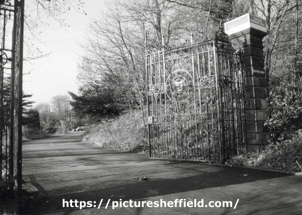
Gates at the entrance to Tapton Masonic Hall, Shore Lane. 19th November 1987. u12334 Interior of Masonic Hall, Tapton Hall, Shore Lane. 4th September 1999. https://www.picturesheffield.com/frontend.php?keywords=Ref_No_increment;EQUALS;u10053&pos=7&action=zoom&id=71205 https://www.picturesheffield.com/frontend.php?keywords=Ref_No_increment;EQUALS;u10054&pos=8&action=zoom&id=71206
-
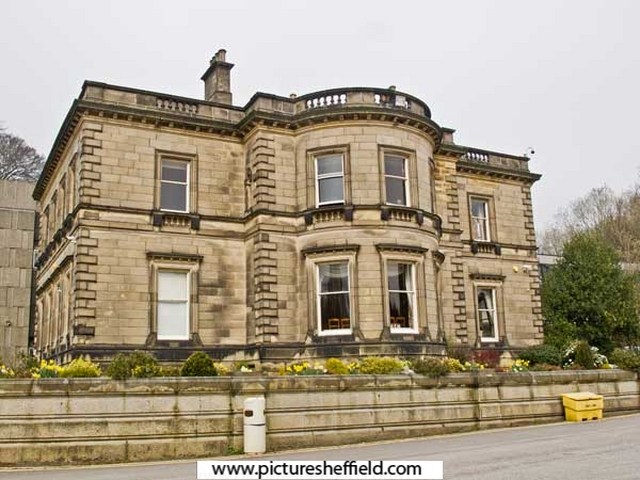
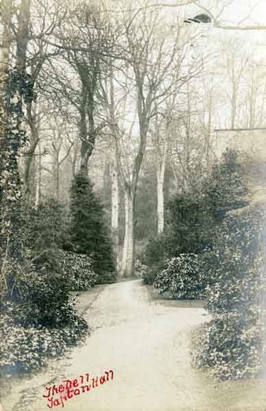
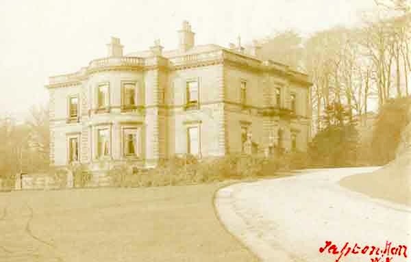
Tapton Hall, Shore Lane., 21st March 2012. c04059 Photographer Alex Ekins. Grade II Listed Tapton Hall, was built in 1855 for Edward Vickers by William Flockton on the site of Tapton Grove, home of the Shore family. Built by Joseph Badger, the Grove was bought by Sheffield banker William Shore in 1790, who enlarged it. William & his wife Mary, nee Evans, were the Grandparents of the famous Florence Nightingale (Mary was the daughter of Anne Evans nee Nightingale). William & Mary's son, William Edward Shore on his coming of age, his Gt. Uncle Peter Nightingale's estate at Lea Hurst, Derbyshire, there after he assumed the 'Nightingale' name & Arms. He married Frances Smith in 1818 and had two daughters, Frances Parthenope b.1819 and Florence b.1820. William Shore died in 1822, and Mary in 1853, after which the Grove was bought by Robert B Mitchell who then sold it on in 1855. Information: S. Hedges. Converted to a Masonic Hall 1966, extension built by Hadfield, Cawkwell and Davidson 1968. p01057 These images were originally part of the Tim Hale Photographic Collection. It was purchased at auction in September 2019 through donations from members of the public and a grant from the Graves Trust. The Dell, Tapton Hall, Shore Lane. p01229
-

Maps of the Parish of Handsworth, based on the Enclosure Award Maps (1805) and corrected up to 1855.
Ponytail replied to Ponytail's topic in Sheffield Maps
Map of Beighton Lane area, c.1855. https://www.picturesheffield.com/frontend.php?keywords=Ref_No_increment;EQUALS;arc02939&pos=2&action=zoom&id=93343 Includes: Birley Vale Branch Railway, Beighton Lane, Lamb Croft Lane, Quarry, Ochre Dyke, Cliff Bridge and Green Gate Lane. From a volume of Maps of the Parish of Handsworth, based on the Enclosure Award Maps (1805) and corrected up to 1855. Dimensions of original: 34 x 51cm. Original at Sheffield City Archives: CA369/1. -
Dore Enclosure Map. 1822. https://www.picturesheffield.com/frontend.php?keywords=Ref_No_increment;EQUALS;arc07355&pos=15&action=zoom&id=106542 Marked: Manor of Hathersage, Burbage Brook, Burbage Rocks, Road from Buxton, Fox House, Buxton Turnpike Road [Hathersage Road], Road from Dronfield, Road from Stoney Middleton, Wooden Pole Road Stony Ridge Road], Dore Turnpike Road, Totley Moors, Dore, Chapel, Oxen Green, Road from Totley, Newfield Lane Road, Limb Gate [on Limb Lane], Standhills, Limb Dyke, Barber Fields, Spring, Ringing Low [Ringinglow], Site of Ringinglow Toll House and Norfolk Arms pub, Ringing Low Road [Long Line], Sparrowpit Gate Turnpike Road [Ringinglow Road], Ox Stones, Oxstone Dale Road, Parkinsons Spring, Red Car Road [Sheephill Road], Aqueduct, Sheep Hill Sping, Me and Jane [Meg and Jane?] Spring White Low Spring, White Low Road, Round Seats, Strawberry Lee Road, Upper Causeway Head, Intake Road [Ash House Lane], Nether Causey Head Road [Parkers Lane / Causeway Head Road], Whirlow Road [Rushley Road]. Tenants / owners marked: Numerous plots - Duke of Devonshire; 29, 30 James Wagstaff; 42 John Frith; 41, 44 Vicar of Dronfield; 50 Curate of Dore; 2, 36, 36a and 85 John Shearwood; 74, 75 Charles Greenwood; 65, 65a, 78, 79 School and Poor; 66 G. B. Greaves; 63, 86 Samuel Shore; 51, 87 Thomas Biggin; 31, 88 Hollis's Hospital; 73, 89 Edward Sampson; 62, 90 W. C. Bagshawe; 52, 91 John Cartledge; 34, 93 John Unwin; 93a I. Shepherd; 14, 32, 94 Henry Hancock; 61, 95 Thomas Fernehough; 6, 33, 96 Robert Moss; 37, 98 and 98 William Cunliffe Shawe; 49, 99 Sir George Sitwell; 48, 100 Dr Ewes Coke; 101 Thomas Bingham, clerk; 102 Joseph Badger's devisees; 103-104 George Canning Esquire; 71 W.G.; 70 P.T.?; 69 P.P.; 68 J.D.; 76 H.M. Scale: approx 5 inches : 1 mile. Surveyors: W and J Fairbank. Signed by the Enclosure Commissioners. Original at Sheffield City Archives: CA361/2.
-
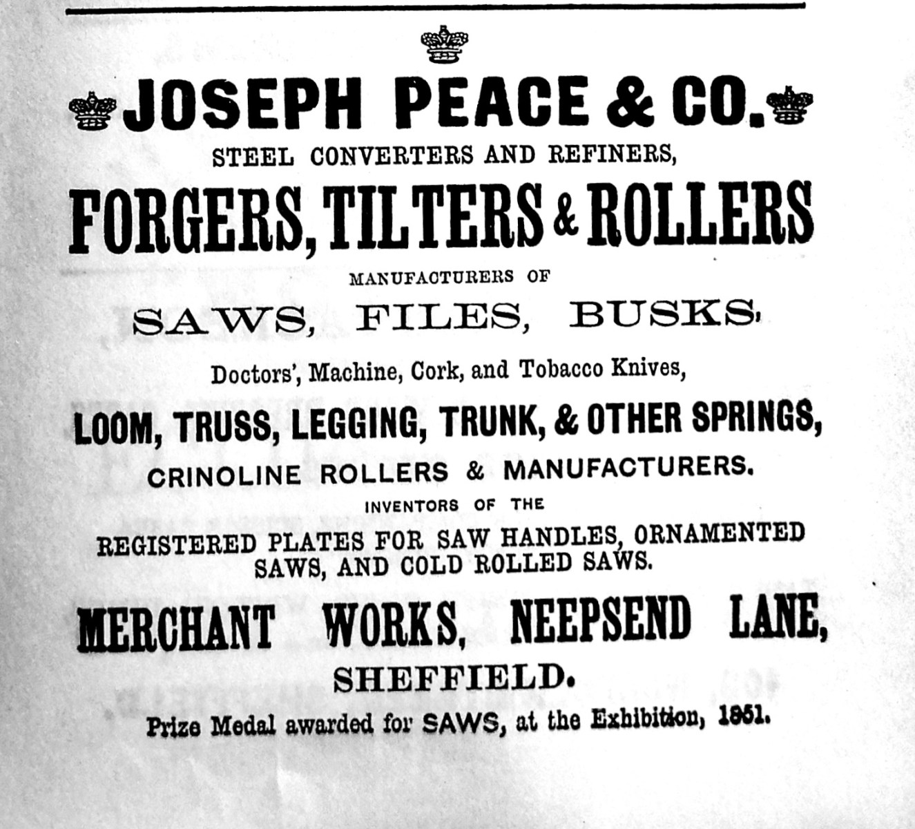
Joseph Peace & Co., Merchant Works Neepsend Lane. From Advertisement Illustrated Guide to Sheffield, Pawson and Brailsford 1862 1858 Company Registered 1918 Incorporated in Sheffield Steel Products Ltd. https://www.gracesguide.co.uk/Joseph_Peace_and_Co
-
Dixon Lane, bridge over the river.
Ponytail replied to Roger Stevenson's topic in Sheffield History Chat
The Canal Basin measured for the Duke of Norfolk, with the line of Exchange Street plotted, [1817] https://www.picturesheffield.com/frontend.php?keywords=Ref_No_increment;EQUALS;arc04186&pos=50&action=zoom&id=104945 Marked: The Wicker, Blonk Street, Ladys Bridge, weir, River Dun [River Don], intended bridge [Blonk Bridge], Wain Gate, Town Hall, Castle Hill, Castle Street, Castle Folds, Hay Market, Tontine [Tontine Inn], Dixon Lane, Sheaf Bridge, River Sheaf [intended bridge], Broad Steet, hospitals and chapel [Shrewsbury Hospital], shuttle, warehouses, [canal] Basin, Soap House. Plan of Sheffield Castle about 1700 (1706?) drawn in the 1930s https://www.picturesheffield.com/frontend.php?keywords=Ref_No_increment;EQUALS;y09509&pos=56&action=zoom&id=64229 A plan of the House, Croft, etc. near the Hospitals held under the Duke of Norfolk by George Crook, containing in all 3a [acres], 3r [rods], 3p [perches] 1769. https://www.picturesheffield.com/frontend.php?keywords=Ref_No_increment;EQUALS;arc03384&pos=61&action=zoom&id=98620 Land between Broad Street, the River Sheaf and South Street. Crookes [Crook's] Croft, on the west bank of the Sheaf, south of the Shrewsbury Hospital; new Coal Road marked, with acreage taken for it; buildings, summer house and well; acreage of the whole. Coloured, on parchment. (Sheaf Lane, Sheaf Street, Granville Hill, South Street, Shrewsbury Hospital) -
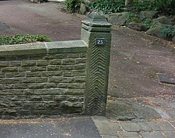
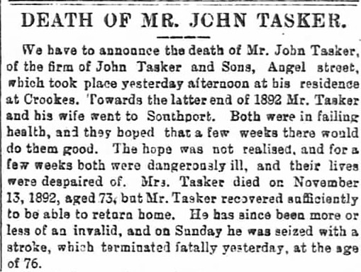
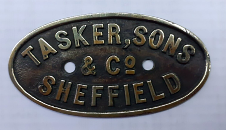
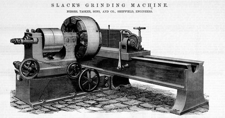
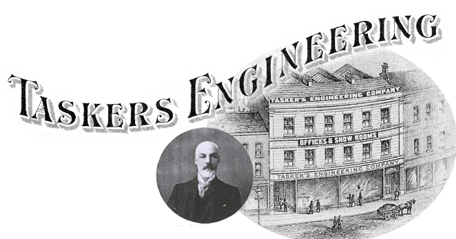
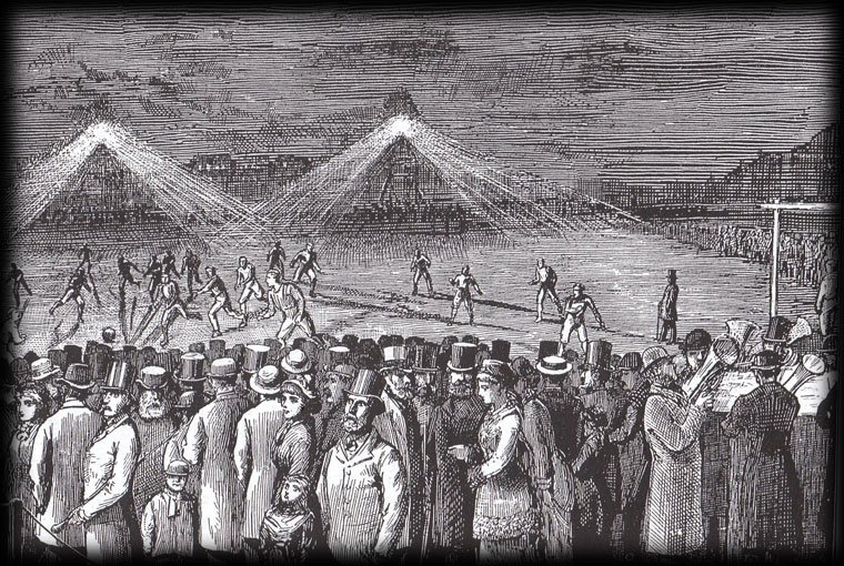
The gate post in the photograph can be found on Taptonville road, In the year 1879 Mr John Tasker was the resident, John Tasker was born in the county of Devon in 1819, by trade he was a boot & shoe maker, I couldn’t say what made John Tasker to up sticks and move to Sheffield, everybody needs shoes or boots, I would have thought coming here had better opportunities than living in a rural area of Devon, in the 1825 directory of Sheffield, John can be found as a shoe maker at number 2 Pond Hill, in the 1833 directory he’s still at the same address but he’s also living there too. His boots and shoes seem to have been very well made as by 1849 he’s listed at 88 Division Street, bigger premises and a bigger order book, just a year before his wife Emma gave birth to John Jnr, by 1851 John was employing 6 men, his family now had grown and along with his wife Emma 31, they had daughter Adela 5, son John Henry Royle 2 and baby William 2 months old. 1862 saw John listed as follows, India rubber & gutta percha merchant and worker, plumber, & patent pump manufacturer, at 32 Angel street, he in fact introduced gutta-percha and India rubber to Sheffield, from his premises on Angel Street, he had progressed to supplying leather drive belts for the many factories in the town, it was around this time he started to the engineering side of the business, which took off at an alarming rate, so much so they moved to larger premises on Station Road and eventually became Tasker`s Engineering Co, I should imagine fifteen year old John Jnr was now working alongside his father learning the business, as proof of his success he moved into 23 Taptonville Road around 1877. The same year he established one of the first telephone exchanges in the provinces, at his Angel Street store; this became the Sheffield Telephone Exchange but demand was slow to build up, 1875 saw him installed as the Mayor of Sheffield. In the true pioneering spirit he then continued to involved himself in telecommunications and his Angel Street store became one of the first telephone exchanges in the provinces. Becoming a name of importance in the telephone business he installed private exchanges for Queen Victoria at Windsor Castle and Balmoral. The greater resources of the National Telephone Company overcame the Sheffield Company and this came to a conclusion in 1888. The other private venture (electricity) came to an end when Sheffield Corporation purchased the electricity undertaking in 1898. Sadly his beloved wife, Emma, died in 1892, the same year he retired, John died at his home in Lawson Road just three years later. On the 14th of October 1878, John Tasker instigated the very first football match under floodlights anywhere in the world, the match was between Sheffield F.C. and Hallam F.C. to the delight of the committee the attendance was over 12,000 and the gate receipts amounted to £300, some say the crowd was nearer 20,000, many of whom climbed over the fence, the lights were more exciting than the match which ended in a boring 0-0 draw In fact the craze for floodlit football was short-lived it was ten years later in 1888 when it took off again and that was due almost entirely to the development of what was known as the Wells Lamp which was to prove both a reliable and effective source of illumination. But to go back to the first game at Bramall Lane. I quote from Chris Hobbs website “The consensus was that the event had been a great success. - the gate at Bramall Lane that night was the highest ever for an association match in England but it must be noted that a fair proportion of the crowd were there to witness the artificial lighting and not the football. There is no doubt that the success was due to the careful planning and preparation of the event - the game coincided with a full moon providing a modicum of natural light - and the weather for once that autumn was favourable. The other factor that cannot be under-estimated is that the lighting was provided and arranged by a Mr John Tasker Sons and co of Angel Street Sheffield who were already forerunners in this new field of electricity”. Adaptability, was John Tasker`s motto, and he turned his hand to almost anything from the invention of a bouncy ball to a way of mending galoshes using India rubber. His involvement with rubber opened his eyes to electricity via wire insulation, and he was particularly intrigued by the phone, once Graham Bell's invention arrived in England. This prompted him to open Sheffield's first telephone exchange with just 12 subscribers, using the Williams sliding spring-peg switchboard. The telephone was just one element in Tasker's appetite for all things electric. He also helped build Sheffield's first power station and electricity supply network. A contemporary of John Tasker described him as The short, rather ungainly figure, so well-known in the centre of the city in the 'seventies and 'eighties, gave no indication of the busy, active brain which governed it, but a glance into Mr. John Tasker's keen eyes revealed something of the indomitable will, the almost dauntless courage which spurred him on to researches which have left undying marks on the story of Sheffield's progress. Today Tasker’s Engineering are one of Britain’s leaders in their field specialising in hydraulics based at Roman Ridge Road, a world away from making boots and shoes by hand.

- 1 reply
-
- 1
-

-
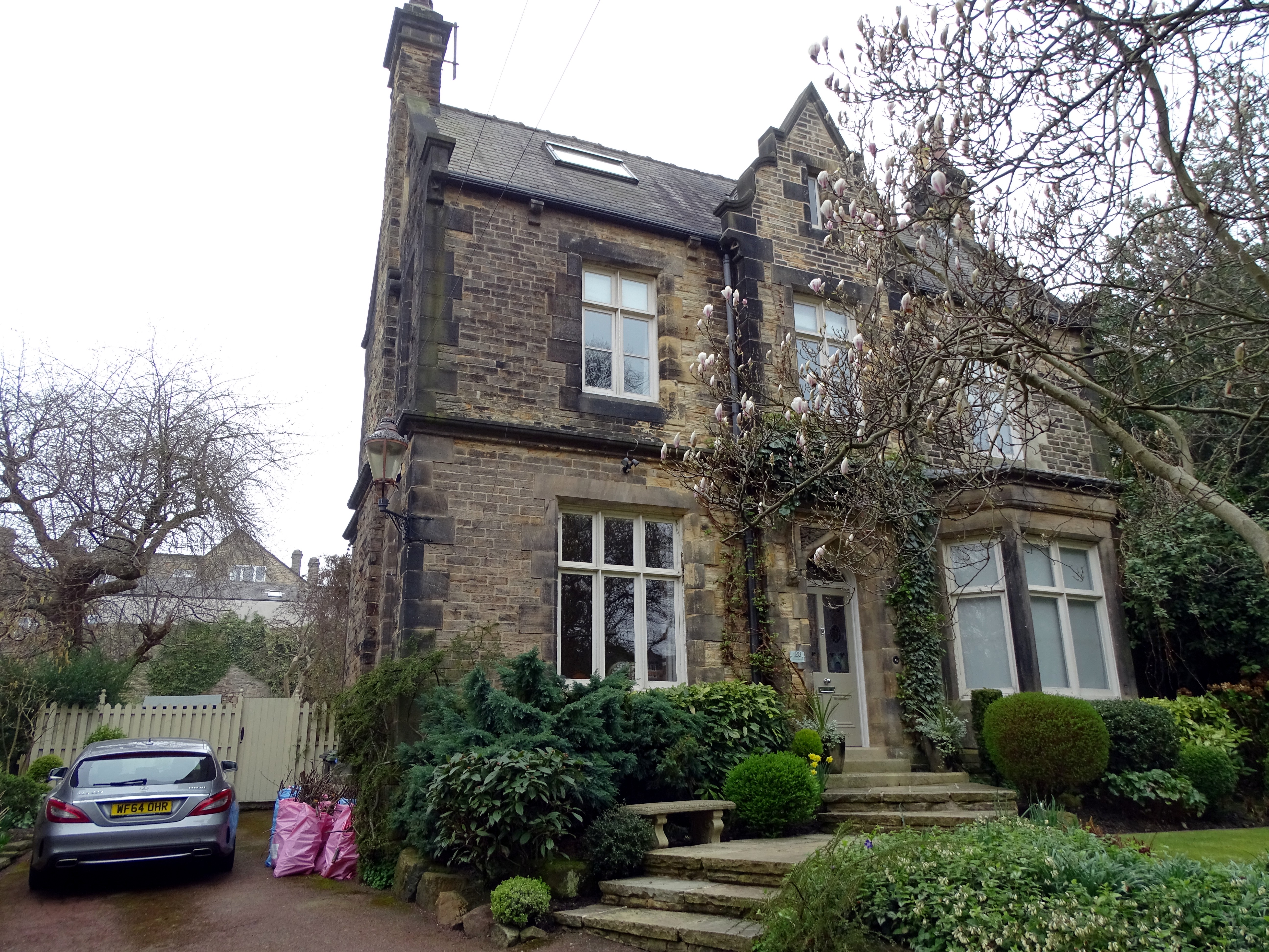
Tapton Court, Shore Lane, Broomhill. Built for John Henry Andrew (1824-1884), steel manufacturer, Toledo Works (J.H. Andrew & Co.) Henry Steel (1832-1915) one of founders of Steel Peech & Tozer lived at Tapton Court 1879-1915. https://sheffielder.net/2020/04/16/tapton-court-a-brass-castle-above-the-fog-of-the-town/ Has further links to: Tapton Court: When the nurses moved in. A brighter future for Tapton Court. Henry Steel. More photographs to view on Picture Sheffield.
-
Many local steelworks had their own barges. Tinsley Rolling Mills brought coal to the works on their own craft until , I believe, the 1920s. One was wrecked and it’s remains could be seen when the River Don was in low water. One of the companies long serving workman, Darkie Hercock ,was actually born on one of the Companies barges.
-
The Story of Jack Timms, founder and builder of Pinegrove Country Club. University of Sheffield Alumni, 9th June 2022. https://www.sheffield.ac.uk/alumni/news/story-jack-timms Pinegrove Country Club, Myers Grove Lane, Stannington. 11th June 1981. https://www.picturesheffield.com/frontend.php?keywords=Ref_No_increment;EQUALS;s32165&pos=1&action=zoom&id=65384 https://www.picturesheffield.com/frontend.php?keywords=Ref_No_increment;EQUALS;s32166&pos=2&action=zoom&id=65385 Pinegrove Country Club 2008. https://www.geograph.org.uk/photo/971256
-
It looks to me like something put out by the Canal companies about the impact of railways on their business. However, I would take the rail figures with a pinch of salt. As we know, the Railways slaughtered the canal traffic and the cost by rail and being cheaper was enough for them to get scared of this new method of transport. With something like that document, you have to take in the motives of who would pay for the expense of publishing it. The document does say "probable" costs. It might be something to do with the canal interests trying to stop Coal Companies actually backing or investing in future rail developments! Showing they wouldn't save much on the short distances and loose on the long ones. There was often some strong opposition to rail expansion.
-
Not always. Many collieries had their own staithes, but then other collieries had rail loading facilities. Wagons are often shunted and spend time in sidings awaiting the next train, boats keep going. Large consumers or merchants may have a private basin, then again they may have a rail connection. You'd need to know the detailed provision for each trip to get an idea of speed. The document is dated 1800-1850, but the start date is way too early, the S&D opened in 1825 and the L&M five years later so what the earliest rail to Sheffield was I don't know. At that early date what speed did railways operate at? Finally, coal does not deteriorate in the timescales we are talking about so does speed matter at all? 30 miles is a day's canal journey, but then add lockage time, may be a couple of days.
-
Map showing the position of the Cleakam (Cleakham) Inn, above Green Lane near to Morton Wheel. Not to be confused with Cleakum Inn at Malin Bridge. Plan of lands in dispute between the townships of Sheffield and Nether Hallam describing them as they were in the year 1783 according to a survey thereof made by the late William Fairbank of Sheffield. Dated 1826. https://www.picturesheffield.com/frontend.php?keywords=Ref_No_increment;EQUALS;arc03895&pos=2&action=zoom&id=97344 The ground concerned includes Upperthorp [Upperthorpe], Port Mahon, Nether Thorp [Netherthorpe] and the land between White House Lane (Infirmary Road) and Morton Wheels. Includes John Addy's house, Lidgate Field, Shales Moor Close, White House Lane or Walkley Road, Penistone Turnpike Road, old road from Owlerton to Sheffield, Green lane, Cleakam Inn, Morton Wheel and Morton Wheel Dam, River Dun and Bacon's Island etc. Cornish Street was previously known as Cleakham Wheel Road. A plan of the building lot in Cleakham Wheel Road [Cornish Street] taken of Thomas Shepherd by Henry Ibbotson. 1823. https://www.picturesheffield.com/frontend.php?keywords=Ref_No_increment;EQUALS;arc04196&pos=6&action=zoom&id=105072 Globe Works shown. Sheffield History A-Z Public Houses List: Cleakham Inn, Cornish Place. Open 1800 Closed Span Comments: open circa 1800; 1822 Cleakem Inn, Green Lane 1822 Amelia Facey/Faser/Fraser 1825 Thomas Hobley According to Michael Liversidge in his book "The definitive A-Z listing of Sheffield Public Houses. "...the only known fact was that the landlord was the owner of a bowling green, which was attached to the Cleakham. A Thomas Hobley or Thomas Copley was the landlord in 1839."
-
Not sure how these plans help but anything I find mentioning Golden Cross I'll post. A map of a Close belonging to the Duke of Norfolk now subdivided into gardens, and late under Lease with the Golden Cross in Sheffield. 1777. https://www.picturesheffield.com/frontend.php?keywords=Ref_No_increment;EQUALS;arc03127&pos=4&action=zoom&id=98112 The second close as shown in ACM/MAPS/SheS/1532a, now entirely divided into gardens; numerical list with tenants names, descriptions and measurements; both these closes may be seen also on ACM/MAPS/SheS/1534. Shows 'Burying ground of the people called Quakers'. Also shows the proposed route of Garden Street. Original at Sheffield City Archives ref. ACM/MAPS/Shes/1533L. A plan of the Ground and Tenements in Campo Lane the property of the Duke of Norfolk, formerly let with the Golden Cross, containing in all 1,080 yards. 1777. https://www.picturesheffield.com/frontend.php?keywords=Ref_No_increment;EQUALS;arc03117&pos=3&action=zoom&id=98098 Surveyor: William Fairbank II. This plan supplements ACM/MAPS/SheS/1581, showing in detail the tenements at the point later to be the junction of Vicar Lane with Campo Lane; tenants; buildings named. (south side of Campo Lane; Hawley Street, Lee Croft). Original at Sheffield City Archives: ACM/MAPS/SheS/1576s.
-
For Reasons Which Will Become Apparent Eventually ...
Ponytail replied to RichardB's topic in Sheffield Genealogy
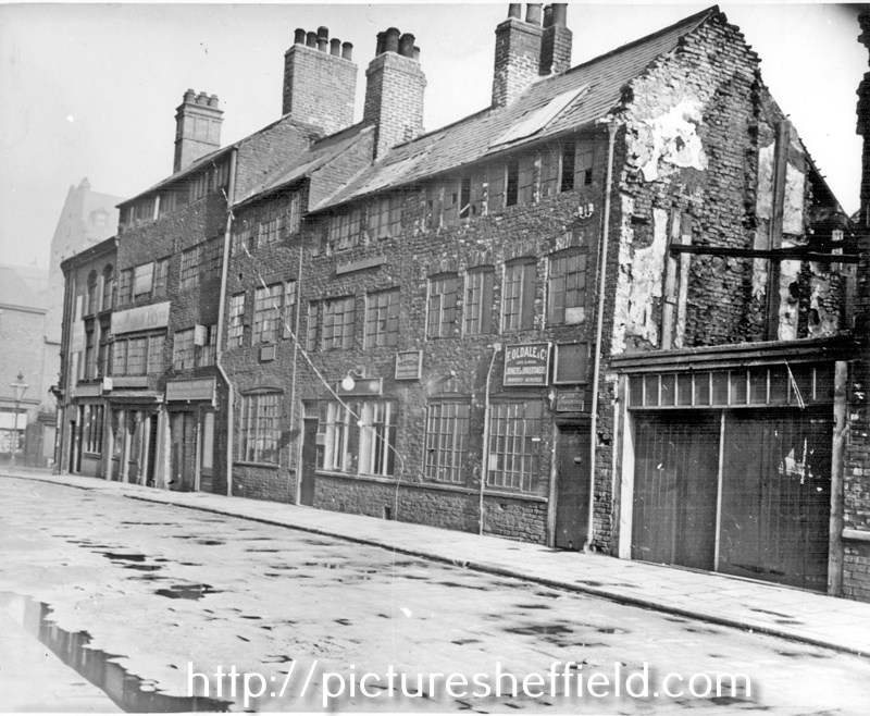
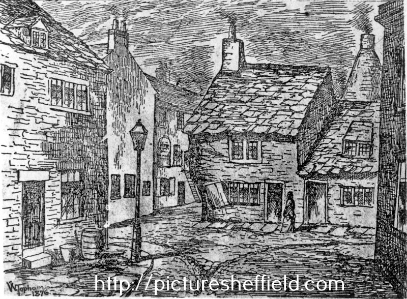
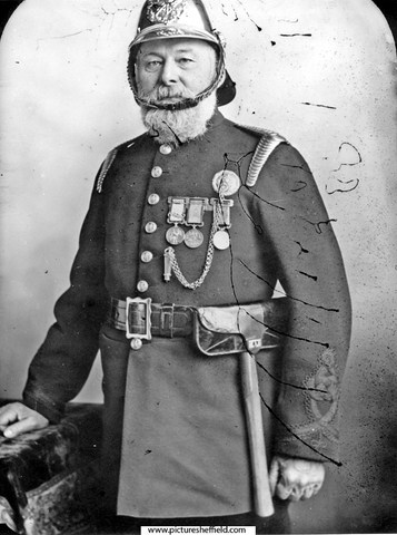
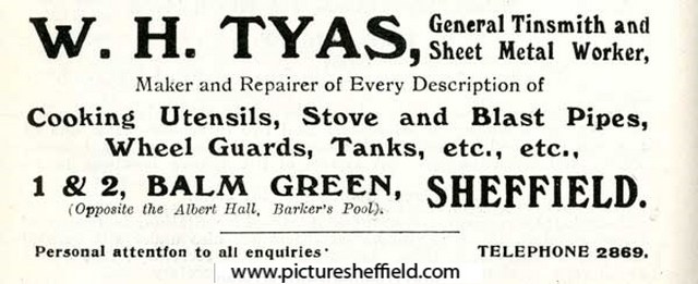
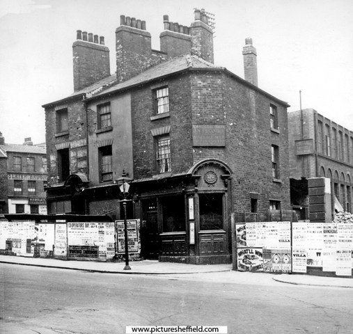
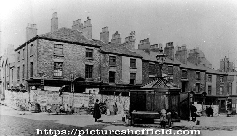
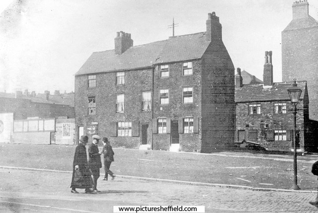
Plan of the corner of Balm Green and Blind Lane, measures taken in Balm Green to fix the line of Division Street where it will pass through the Towns' property; sketch showing the street after the demolition of the old Town property, [1792], 18. https://www.picturesheffield.com/frontend.php?keywords=Ref_No_increment;EQUALS;arc04094&pos=301&action=zoom&id=103509 Three plans pasted together. Shows Division Street, Coalpit Lane, Blind Lane and Balm Green. Tenants / owners marked: Thomas Sayles, Thomas Bennett, John Smith, Edward Brownell, Edward Harrison, Thomas Bennett, Sarah Potter, John Beavans, Timothy Millington, late Sephton, now Thomas Marshall. An outline of the land between Barker's Pool and Church Street, with Brelsforth's Orchards coloured green, 1804. https://www.picturesheffield.com/frontend.php?keywords=Ref_No_increment;EQUALS;arc04039&pos=123&action=zoom&id=103300 Leopold Street, Balm Green, Orchard Lane and Fargate shown (but not labelled). Refers to S. A. Younge, furnace, James Creswick, Jonathan Moor, Malin Gillott and others, Allen and White, Richard Ibberson, Edward Brownell, Christopher Oates, Edward Adamson, Thomas Maxfield and others, Thomas Sayles's freehold, Thomas Bennett, John Smith, Town Land, John Brookes, Sarah Potter, Barkers Pool, John Lindley's freehold, Duke of Norfolk - given in exchange to the To-- [Josep Holland?], George Woollen, William Pavell, Samuel Younge, Rose, Charles Milner, John Jenning, - Webster, William Rowley and tenements and ground proposed to be taken by E? Brook [Brookes?]. Photographs Date Period:1900-1919 Cottages at Balm Green, site of City Hall, on the left are the furnaces of the Queen Steel Works belonging to John Lucas, iron and steel merchant on Holly Street. 1900.s00689 Balm Green, including F. Oldale and Co., joiner and undertaker, No 2 Balm Green. s13218 Fred Oldale (1878-1940) appears on censuses as journeyman joiner until the 1921 census when he is recorded as a joiner and undertaker in the employ of Robert Moss a joiner, builder and undertaker. Robert Moss is listed in Whites 1901 directory at Balm Green as a joiner, builder and undertaker. Balm Green from Holly Street. s19361 Artists Impression of the Cottages at Balm Green, site of City Hall. Entrance to Court No 4, left. Furnaces in the background belong to the Queen Steel Works belonging to John Lucas, iron and steel merchant on Holly Street. 1876.s13220 W. Topsham, Artist. Partly demolished row of buildings known as Pool Place, Barker's Pool (later the site of the City Hall). Former premises include New Music Hall Tavern, No 116, Barker's Pool, on corner. s00243 Shops on Barkers Pool known as Pool Place, prior to demolition in preparation for the War Memorial, note the 'Iron Man' Public lavatory. Holly Street, left. 1923. s00374 Barkers Pool, later site of City Hall, looking towards housing on Balm Green. Houses on right front Court No. 2. 1927.y01592 Balm Green from Division Street. Court No. 4 left (note sign for Robert Moss, joiner and undertaker), Court No 2, right (behind wall)y01403 Photograph shows Grand Hotel in process of building. Balm Green was behind Barkers Pool on site of City Hall. The sign of a joiner and undertaker shows the name R. Moss. Prior to this, Robert Moss, whose residence was at 16 Monmouth Street, owned the Wentworth Temperance Hotel in Holly Street, where the Grand Hotel later stood. Robert Moss had one son and a daughter. He had a lifelong connection with Bethel P.M. Chapel in Cambridge Street and was choir master and Sunday School Secretary for many years. At the Anniverary Services he often entertained the members of the voluntary instrumentalists who accompanied the singing, to dinner and tea between the services at the Wentworth Hotel, being near to the Chapel. John Charles Pound (c.1833-1918), Superintendent of Fire Brigade, c.1870 s08453 Pound was born in Sittingbourne in Kent c.1833. In the 1850s he was a fireman at Lambeth. He relocated to Sheffield c.1870. In the 1880s he was living at Balm Green with his wife and seven children. His first two children were born in Surrey – the remainder in Sheffield. During his time at Sheffield he applied to join Birmingham and Glasgow fire services but presumably was unsuccessful. He resigned from the Sheffield Fire Service in September 1895. He died on 25th October 1918 and was buried in the Sheffield General Cemetery. Advertisement for W. H. Tyas, general tinsmith and sheet metal worker, Nos. 1-2 Balm Green. 1916. y05257 Image from Sheffield Telegraph Year Book 1916 (page 110) (Local Studies 032.74 S).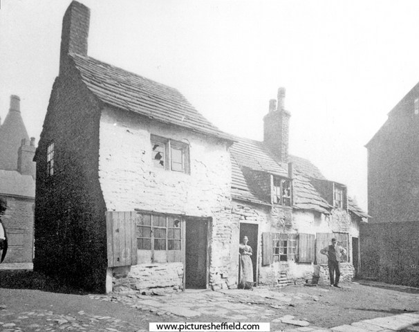
-

Old Sheffield tram routes - bit of confusion !
Edmund replied to Roger Stevenson's topic in Sheffield History Chat
The Sheffield Corporation Act of 1900 gave powers for a number of tram routes to be constructed, some of which were never followed up. One of these was the route from the junction of Cemetery Road and Washington Road, along the upper part of Cemetery Road and Psalter Lane to Banner Cross, with a link along Cowlishaw Road and Junction Road to Hunters Bar. Discussion of this progressed as far as a proposal in May 1900 to pave Cemetery Road in granite when the tram lines from Washington Road to Sharrow Head were laid. During 1908 Psalter Lane residents held meetings against the proposed extension, they said that the existing Ecclesall and Nether Edge services were adequate and that Psalter Lane was the only main route out of Sheffield unspoiled by tramcars. There were calls in council meetings to veto the extension, for which authorisation had been renewed in a 1907 Act, and in 1909 the plan for this extension was abandoned. By then the Corporation were trialling motor buses for new routes, for which they had received the authorisation in 1907 . The electricity supply system was initially shaped by the huge requirements of the tramways. In 1902 the Sheaf Street power station was changed over to 50Hz generation, more suitable for lighting. In 1904 the Neepsend power station came into use. -
Plan of the Queen's Foundry, Queen Street and premises adjoining in Sheffield. 1842. https://www.picturesheffield.com/frontend.php?keywords=Ref_No_increment;EQUALS;arc04225&pos=4&action=zoom&id=105209 Marked: Model warehouses, stable, stable loft, manure, old warehouse, shed, smiths and joiners shops, foundry, boring and turning mil, engine house, dwelling house, ash pit, privy, reservoir, counting house, fetling shops, sand and core shed, fitting shops, model and lumber rooms, and furnaces. Wardle & Bentham 1814-1815 Iron founders & Masters Darwin & Co., Queens Foundry, Chapeltown, Elsecar & Worsbrough. General & Commercial Directory of Sheffield. 1825. Darwin & Co. mill & engine work in all of its branches, Queens Foundry, Queen Street. White's General Directory 1849. Darwin & Co, New Queen Street, iron founders; stove grate; mill and engine work manufacturers, Queens Foundry, New Queen Street. Thomas Darwin, iron founder & etc. h. 77 Occupation Road. Whites Directory 1852. Darwin & Co. iron founders; stove grate; engine and mill work manufacturers, Queens Foundry, 68 New Queens Street. Thomas Darwin, iron founder & etc. h Handsworth. Whites Directory 1862 Darwin & Co. iron founders & stove Grate & etc manufacturers, Queens Foundry 68 Queens Street. John Darwin, public weighing machine proprietor, 68 New Queen Street. Samuel Darwin, iron founder & Co. (Darwin & Co) h. 8 Hanover Square. Thomas Darwin, iron founder & etc., h. Blenkarn Place, Rock Street. White's Directory 1872 . Darwin & Co. engineers, millwrights, iron founders; general stove grate manufacturers; silversmiths; coppersmiths; tinner brazier tool manufacturers, 98-108 Queen Street. Thomas Darwin, (D & Co) h. 99 Rock Street. Which Queen? Thought it would be Queen Victoria until discovered it was named Queens Foundry earlier. Probably Queen Charlotte wife of George III. Queen, 8th September 1761-17th November 1818. Crowned. 22nd September 1761.
-
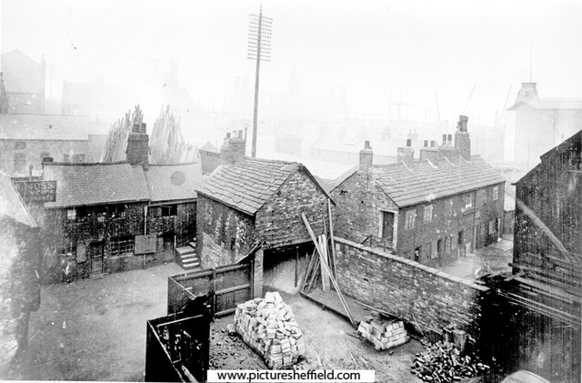
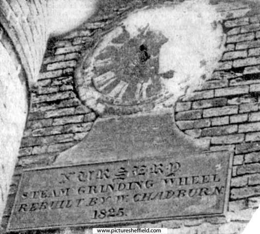
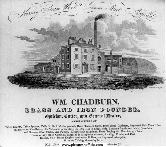
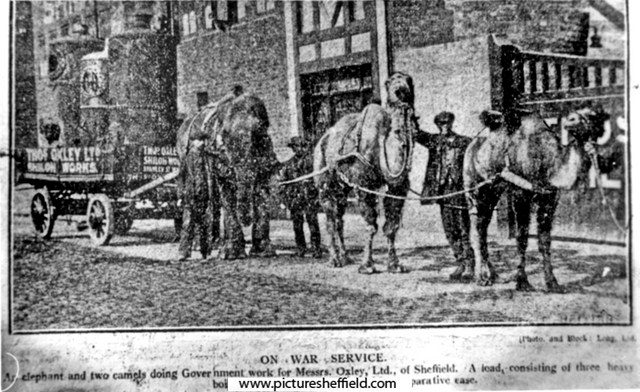
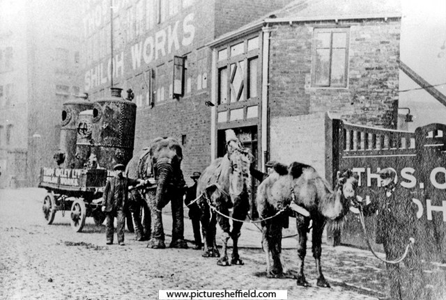
A plan of the Cutler's Steam Grinding Wheel with the small tenements and vacant ground adjoining the same situate in the Nursery, Sheffield. 1822. By John Leather, land surveyor. https://www.picturesheffield.com/frontend.php?keywords=Ref_No_increment;EQUALS;arc04148&pos=10&action=zoom&id=104078 Marked: Spital Hill, Stanley Street, Johnson Street, Andrew Lane, engine yard, smiths sop, boilers, geering [gearing?], engine house, proposed mill, tenement and sough from the river. Nursery Steam Grinding Wheel also known as Shiloh Works. Advertisement for William Chadburn, Brass and Iron Founder, Nursery Steam Wheel, junction of Stanley Street (left) and Johnson Street. Works also known as Shiloh Works. 1828. s10911 Taken from Blackwell's 1828 Directory of Sheffield. Undated newspaper cutting. On the Johnson Street side of the Shiloh Works in Stanley Street, Sheffield is this interesting old tablet. The inscription reads: "Nursery Steam Grinding. Rebuilt by W. Chadburn, 1825." Above there are the remains of a clock dial. s09994 Situated on the Johnson Street side of the Shiloh Works (main entrance off Stanley Street). Refers to William Chadburn, Brass and Iron Founder. Sheffield Flood Claim. Alfred Chadburn, Steam Grinding Wheel Proprietor. Wood Bank, Burngreave Road, Sheffield, for Claim as Owner for damage & loss of rents at the Nursery Steam Grinding Wheel. https://sheffieldfloodclaimsarchive.shu.ac.uk/claimSummary.cfm?claim=1-1210 James Thorpe. horn cutter, Chadburns Wheel, Sheffield living at 36 Fitzallan Street. https://sheffieldfloodclaimsarchive.shu.ac.uk/claimSummary.cfm?claim=4-3629 Henry Palmer, wood turner, Chadburns Wheel, Stanley Street, Sheffield. https://sheffieldfloodclaimsarchive.shu.ac.uk/claimSummary.cfm?claim=6-5046 Sarah Kenworthy, Administratrix of George Kenworthy, late Number 11 Nursery Lane, spinster living at Mr. Chadburn's, Nursery Street; late Number 11 Nursery Lane. https://sheffieldfloodclaimsarchive.shu.ac.uk/claimSummary.cfm?claim=6-5352 Sarah Kenworthy of Nursery Street Administratrix of George Kenworthy late of No.11 Nursery Lane. Claim for the child of late George Kenworthy. https://sheffieldfloodclaimsarchive.shu.ac.uk/claimSummary.cfm?claim=9a-100 The claim suggests George Kenworthy died as a result of the Flood; however he isn't on the list of named dead published in "The Great Flood at Sheffield" Did he die because of complications afterwards or is he an omission to the published list? Employees at Chadburns Wheel, Nursery had their Claim for loss of wages dismissed. John Gormley, spring knife cutler of 8 Bate's Square. https://sheffieldfloodclaimsarchive.shu.ac.uk/claimSummary.cfm?claim=1-1224 John Mason, spring knife cutler of 113 Hammond Street. https://sheffieldfloodclaimsarchive.shu.ac.uk/claimSummary.cfm?claim=1-1227 James Allender, spring knife cutler of 4 Furnace Hill. https://sheffieldfloodclaimsarchive.shu.ac.uk/claimSummary.cfm?claim=1-1228 On War Service for Thomas Oxley Ltd., Shiloh Wheel, Stanley Street. 15th April 1916. s09993 Sheffield Telegraph 15/04/1916 (See also Sheffield Independent for same date) An elephant and two camels doing Government Work for Messrs. Oxley Ltd. of Sheffield. A load consisting of three heavy boilers is being drawn along with comparative ease. Shiloh Works were at Shiloh Wheel also known as Nursery Steam Grinding Wheel see Directory 1919-20. s00065 Thomas Oxley Ltd. https://hawleysheffieldknives.com/n-fulldetails.php?val=o&kel=1319 Stanley Street from Spital Fields, showing old works formerly known as Nursery Steam Grinding Wheel also known as Shiloh Works. Johnson Street in background. 10th June 1943. u02690 Johnson Street from Stanley Street, showing old works formerly known as Nursery Steam Grinding Wheel also known as Shiloh Works. Occupied at time of photograph by Strongs British Twist Drill Ltd & No 27, Johnson Street, Grocers (on left). 10th June 1943. s17536 Photographer: Estate Surveyors Department.

-
8th January 1849 Widening of Snighill, by removal of old projecting property, commenced. Similar improvements made by the Town Trustees in Trippet Lane, Silver Street Head, Coalpit Lane and Gibralter Street.
-
Unidentified Public Houses and Refreshment Rooms
Ponytail replied to Ponytail's topic in Sheffield History Chat
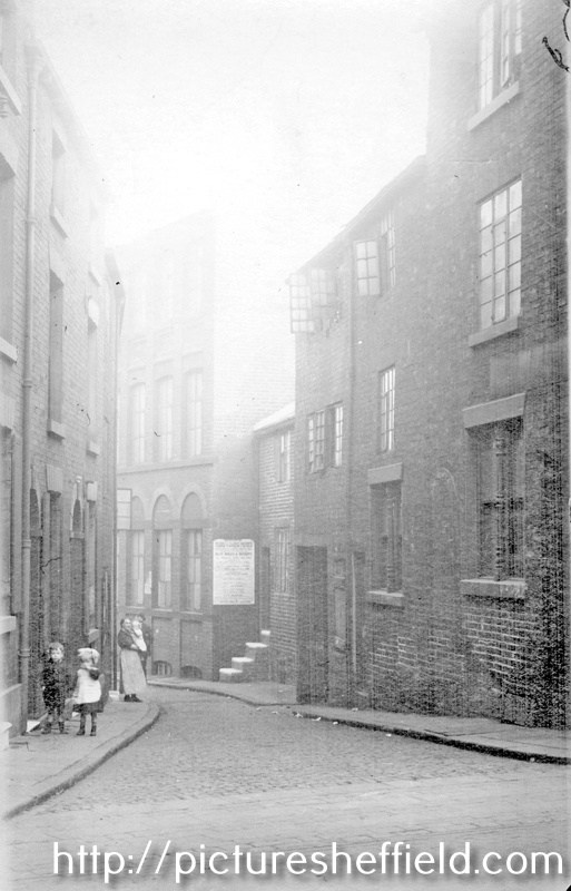
Thank you. Adding more images of Hawley Lane, Hawley Croft etc. Hawley Lane May 1898u09591 2 images of: Derelict Property corner of Hawley Croft & Hawley Lane. https://www.picturesheffield.com/frontend.php?keywords=Ref_No_increment;EQUALS;u01119&pos=49&action=zoom&id=36842 https://www.picturesheffield.com/frontend.php?keywords=Ref_No_increment;EQUALS;u01131&pos=50&action=zoom&id=36854 Old Reindeer public house (sign on lamp left) and properties, Hawley Lane. Date Period 1851-1899 Copyright: Jill Dalton Notes. 1893-4 Directory- No. 5 Hawley Lane, James Sharp, beerhouse 1898- No. 5 John Plant, beerhouse 1902 no beerhouse listed Hawley Lane not listed 1906. https://www.picturesheffield.com/frontend.php?keywords=Ref_No_increment;EQUALS;v00922&pos=33&action=zoom&id=42714 Yard behind Becketts, Hawley Lane, possibly corner of Hawley Lane and Hawley Croft. September 1898. https://www.picturesheffield.com/frontend.php?keywords=Ref_No_increment;EQUALS;u01083&pos=32&action=zoom&id=36810 Hawley Lane. https://www.picturesheffield.com/frontend.php?keywords=Ref_No_increment;EQUALS;u09585&pos=35&action=zoom&id=56361 Campo Lane at junction with Hawley Croft, Reuben's Head public house on right. https://www.picturesheffield.com/frontend.php?keywords=Ref_No_increment;EQUALS;s02170&pos=31&action=zoom&id=5963 Corner of Hawley Croft and Campo Lane, showing sign for Reubens Head. https://www.picturesheffield.com/frontend.php?keywords=Ref_No_increment;EQUALS;u01097&pos=29&action=zoom&id=36822
-
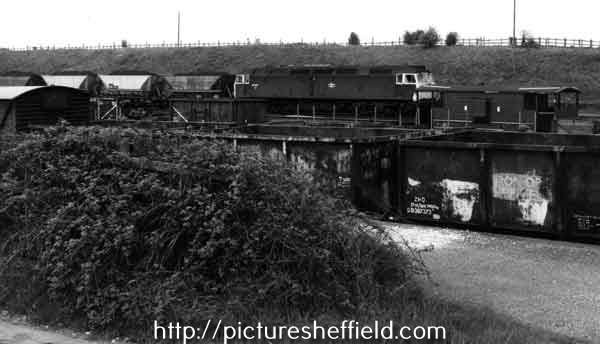
Birley Collieries Branch Line
Ponytail replied to Paolo Coopio's topic in Sheffield Buses, Trams and Trains
Map of Woodhouse junction area, c. 1855. Includes Green Gate Lane; Birley Vale Branch Railway, Beighton Branch Railway, Manchester Sheffield and Lincolnshire Railway; River Rother; Woodhouse Colliery; Woodhouse Mills; Shirecliffe Brook; Cinderhill Green Road; Furnace Lane, Woodhouse Junction Station; shaft. https://www.picturesheffield.com/frontend.php?keywords=Ref_No_increment;EQUALS;arc02940&pos=40&action=zoom&id=93148 Woodhouse (extract from Ordnance Survey of 1935, revised to 1948) https://www.picturesheffield.com/frontend.php?keywords=Ref_No_increment;EQUALS;y06745&pos=12&action=zoom&id=59925 Derbyshire sheet XII NE and Yorkshire CCXCV. Birley East Colliery, Woodhouses10732 For more information about Birley East Colliery see: Winding Up a History of Birley East Colliery, A Rowles Ref: 622.33 SQ. https://www.picturesheffield.com/frontend.php?keywords=Ref_No_increment;EQUALS;s10733&pos=42&action=zoom&id=13859 Viewed from Hackenthorpe side. https://www.picturesheffield.com/frontend.php?keywords=Ref_No_increment;EQUALS;s10735&pos=44&action=zoom&id=13861 East Birley Pit, late 19th century, view from Sally Clarkes. https://www.picturesheffield.com/frontend.php?keywords=Ref_No_increment;EQUALS;t00216&pos=47&action=zoom&id=31083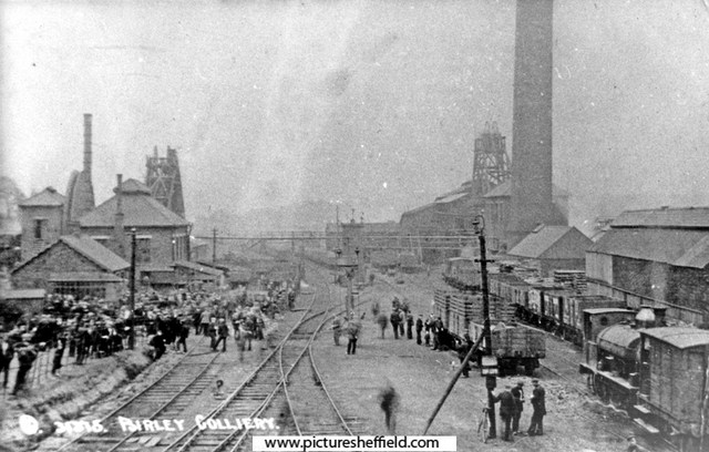
-
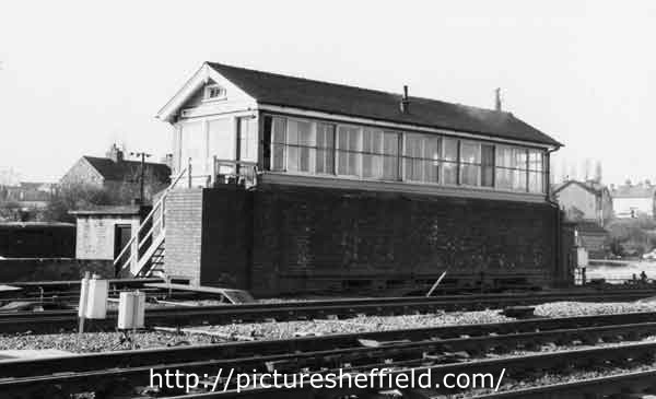
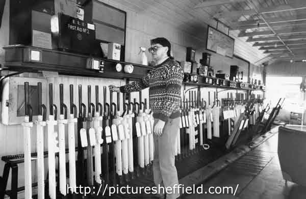
Birley Collieries Branch Line
Ponytail replied to Paolo Coopio's topic in Sheffield Buses, Trams and Trains
Woodhouse Junction signal box. 1978. https://www.picturesheffield.com/frontend.php?keywords=Ref_No_increment;EQUALS;s41720&pos=45&action=zoom&id=81661 Woodhouse Junction Signal Box.13th May 1981.s41716 The wall at the base was built during the war to protect the original structure. 21st February 1989s41717 Woodhouse Junction signal box. 21st February 1989.s41721 Track repair equipment at Woodhouse Junction. 13th May 1981. https://www.picturesheffield.com/frontend.php?keywords=Ref_No_increment;EQUALS;s42766&pos=34&action=zoom&id=83648 Diesel locomotive towing coal trucks at Woodhouse Junction. 13th May 1981. s42769 Further information from J Thickitt: Formerly known as Woodhouse East Junction, where trains towards Lincoln or Grimsby had diverged eastwards from the ex-Great Central Railway main line (closed as a through route in 1966). Among the differences to image reference number s42768 (which was photographed on the same day) are the obviously full Merry-go-Round hoppers hauled by a different class of locomotive. Diesels had been re-numbered during the early-1970s, this one becoming a member of Class 47 (the identification is deduced by the presence of a ventilation-cowl above the windscreen, here viewed in silhouette, see u09073) The taller, brown vehicle extreme left on the nearest track was known on the railway as a van (meaning a covered waggon). s42768 Diesel locomotive towing coal trucks at Woodhouse East Junction. https://www.picturesheffield.com/frontend.php?keywords=Ref_No_increment;EQUALS;s42768&pos=36&action=zoom&id=83650 Mr Thickitt refers to Picture Sheffield No. u09073. https://www.picturesheffield.com/frontend.php?keywords=Ref_No_increment;EQUALS;u09073&pos=2&action=zoom&id=95913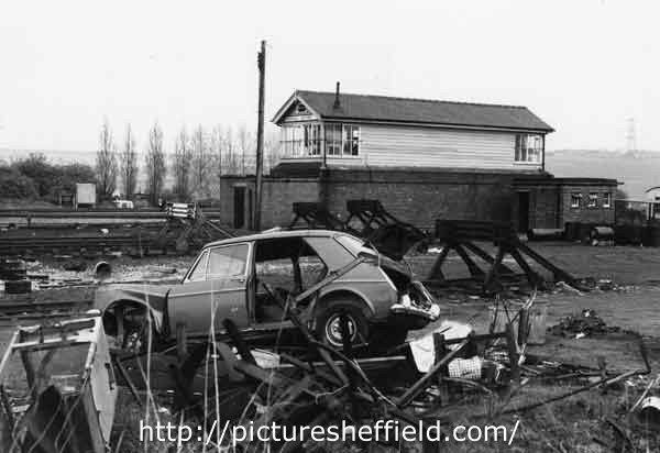
-
We already have a thread on the tramway that John Curr may have been associated with in the transport forum here. But I think that he qualifies as a Sheffield celebrity of sorts. Born in about 1756 in County Durham he moved to Sheffield some time before 1776. Eventually he became the manager of the Duke of Norfolk's Sheffield collieries. He married Hannah Wilson (18 May 1759 - 10 June 1851) in about 1785 and they had at least eight children: Elizabeth Curr (1782 - 1812) John Curr (1783 - 1860), emigrated to New South Wales. Author of Railway locomotion and steam navigation: their principles and practice Mary Ann Curr (1786 - 1868) - married Louis Armand Beauvoisin In 1822 (info from Beauvoisin) Teresa Curr (1790 - ?) Rev. Joseph Richard Curr, baptized at Sheffield 14 April 1793. Died at Leeds 30 June 1847 Harriet (Gertrude) Curr, born in Sheffield 2 Sept. 1795 and baptized four days later at the Catholic Chapel there. Died 30 May 1868. Nun of the Institute of Mary at York Edward Charles Curr (1 July 1798 - 16 November 1850), also emigrated to New South Wales, Secretary of the Van Diemen's Land Company 1824 - 1841. Married Elizabeth Micklethwaite at Sheffield and had 11 children. Author of Account of the Colony of Van Diemen's Land (factlet: the town of Sheffield in Tasmania was named by Edward Curr after his hometown) Juliana Curr (1800 - ?), married Thomas Ellison at Winwick parish church on 13 October 1828; may have also married a Beauvoisin (info from Beauvoisin) He made a number of innovations in coal mining/railway technology whilst at Sheffield, some of which are described in his 1797 book The Coal Viewer, and Engine Builder's Practical Companion. He died at Belle Vue in Sheffield on 27 January 1823. He was catholic and was buried at the catholic chapel which preceded St. Marie's church on Norfolk Row.
-

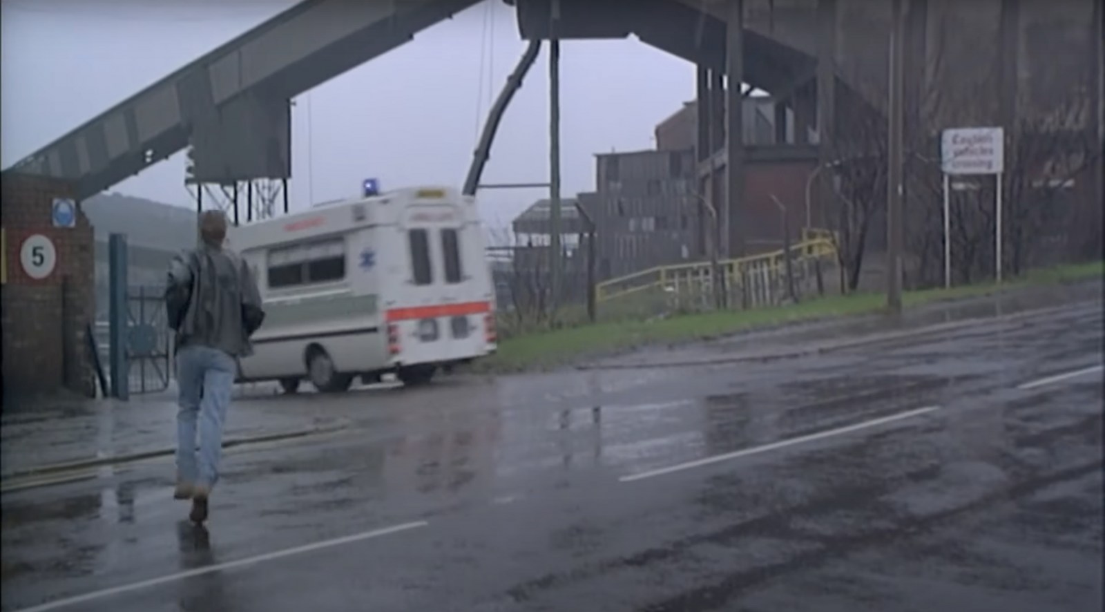
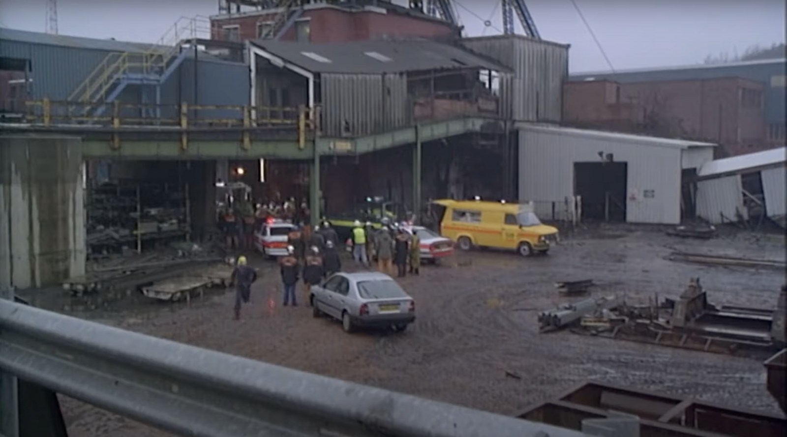
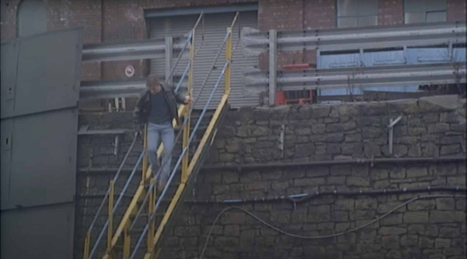
Tragedy at the pit scene - When Saturday Comes Filming Location
Sheffield History posted a topic in When Saturday Comes
A few shots from the pit scene but I've no idea where this one is - can you help? Do you recognise this pit? If so post below and let me know! 👇