Search the Community
Showing results for 'coal pit lane'.
-

Birley Collieries Branch Line
boginspro replied to Paolo Coopio's topic in Sheffield Buses, Trams and Trains
I may be wrong here and apologise if I am but the original picture put on by History dude looks to me like the tunnel/bridge at Coisley Hill just below the Block Houses on Coisley Road. If that is so as kids it was always known as The Tunnel though I think it was just quite a long under bridge. It seems to me to have been accepted as the bridge under Normanton Hill into Birley West pit but if you look at the 1938 picture above of a wagon loading coal at the land-sale site of the old Birley West site you can see how steep that hill is and the difference in gradient to the first picture. -
Shows Edgestones Jessop Street & South Street. Improvements in South Street, Coalpit Lane, Balm Green and Hereford Street, with a selection of part of South Street and Jessop Street, 1825. https://www.picturesheffield.com/frontend.php?keywords=Ref_No_increment;EQUALS;arc04251&pos=2&action=zoom&id=105413 Marked: South Street [The Moor], road from Manchester, Younge Street [Young Street], Bennets Lane [Bennett Lane], Hereford Street, [Jail, Fail, Tail Street?], Bright Street, Cumberland [Street], Jessop Street, T. Holy's garden [Holy Green], Earl Street, Rockingham Street, Landers Lane, Duke Street, Carver Street, Ward Street, Porter Lane, Union Street, Sugar House, Furnival Street, Coalpit Lane, Burgess Street, Cross Street, Pinston Street [Pinstone Street], St Paul's, Charles Street, Norfolk Street, Balm Green, Far Gate, an Division Street.
-
Does anyone have any information about the so called 'Dry Cottages' on Trap Lane. We walk quite frequently down Trap Lane and have noticed what appear to be well built steps and wall remains. We were once informed by passers by that there were a number of cottages just up from the Meadow Farm on Whitely Wood Road. They were supposedly not connected to a water supply and so got their name. I tried to find an early map but was unsuccessful. Any ideas?
-
It appears the widening of Snig Hill was in the planing for a number of years. Plan of proposed street widening at Bridge Street, Coulson Street and Snig Hill. 1845. https://www.picturesheffield.com/frontend.php?keywords=Ref_No_increment;EQUALS;arc06809&pos=12&action=zoom&id=106240 Marked No. 2. Also shown are West Bar, New Hall Street, Love Lane, Spring Street, Bank Street, Water Lane, Angel Street and Castle Street. From a volume of plans of new streets and street improvements, made by Flockton, Lee and Flockton, 1845. Plan for improving Snig Hill and Coulson Street [Colson Steet], [1830s] https://www.picturesheffield.com/frontend.php?keywords=Ref_No_increment;EQUALS;arc04249&pos=8&action=zoom&id=53522 Marked: Bridge Street, Coulson Street, New Hall Street, Spring Street, West Bar, Snig Hill, Bank Street, Angel Street, Castle Street, Angel Inn, and Bank. Plan for improving Snig Hill and Coulson Street; and Plan for improving Shude Hill and Bakers Hill. 1837. https://www.picturesheffield.com/frontend.php?keywords=Ref_No_increment;EQUALS;arc04248&pos=7&action=zoom&id=48088 Marked: Marked: Bridge Street, Colson Street, New Hall Street, Spring Street, West Bar, Snig Hill, Bank Street, Angel Street, Castle Street, Angel Inn, and Bank. Inset - Pond Street, Shude Hill, Bakers Hill. Houses of John Frith and Joseph Frith at Snig Hill, with adjacent property wanted for street improvement. 1836. https://www.picturesheffield.com/frontend.php?keywords=Ref_No_increment;EQUALS;arc04247&pos=10&action=zoom&id=95321 Marked: West Bar, Snig Hill, Colson Street, Three Travellers, Snig Hill, Black Swan, Bank Street, property of Joseph Firth and John Frith, Bank [Bank Street], Angel Street, Angel Inn, Castle Street and Water Lane.
-
And the new tier of local government is all part of Regional Devolvement of powers…with a touch of “ levelling up” I imagine. It’s all down to politics….so let me say that the new scheme is a million times nicer than the Fitzalan Square of the 1960s when I started being a townie in my drinking habits. The old, smelly downstairs loos attracted a certain a”clientele”…so a quick visit was called for before a dash to catch one of the late trams to Lane Top.
-
This Sale Plan of Norton House, although not part of the Norton Hall Estate, may be of interest to someone as it fits nicely into the gap of the Map and bordered by Norton Church and Maugheray. Plan of Norton House situate in the parish of Norton and County of Derby. 1868. By Fowler and Son, Sheffield. https://www.picturesheffield.com/frontend.php?keywords=Ref_No_increment;EQUALS;y11283&pos=3&action=zoom&id=104274 Shows [Norton Lane, Cinderhill Lane, School Lane], Norton Church, Chantry monument, Norton House, Maugherhay, The Oakes, Norton Hall estate, and a school.Owners / Tenants: Norton Glebe (Rev Henry H. Pearson, vicar), William Gascoigne, James Jenkin, James Addy, Frances W. Bagshawe, H. Cunliffe, James Rhodes, Charles Cammell and Norton Hall Estate.
-
A plan of two Closes held under the Duke of Norfolk by Benjamin Roebuck, with Silvester Wheel [Sylvester Wheel] and the adjoining Damms (sic) and Gardens in John Wilson's possession, [c. 1760-1770] https://www.picturesheffield.com/frontend.php?keywords=Ref_No_increment;EQUALS;arc03285&pos=87&action=zoom&id=98446 Upper and Lower Dams, Wheel and Weirs clearly shown; includes two closes to the north of the dams; numerical list with tenants, descriptions and acreages; coloured, on parchment. Sylvester Wheel and the closes to the south (these closes adjoin those in the section above; the wheel was on the Porter Brook near modern Sylvester Street). (Alsop Lane, Earl Lane, Earl Street, Eyre Street, Jessop Lane, Jessop Street, Sylvester Street) Silvester Wheel with the Dams and Appurtenances held of the Earl of Surrey by John Wilson. 1784. https://www.picturesheffield.com/frontend.php?keywords=Ref_No_increment;EQUALS;arc03286&pos=88&action=zoom&id=98447 Wheel, Dams and Gardens clearly shown; measurements of gardens Sylvester Wheel and the closes to the south (these closes adjoin those in the section above; the wheel was on the Porter Brook near modern Sylvester Street). A plan of the Stand Ley Closes, etc. 1790. https://www.picturesheffield.com/frontend.php?keywords=Ref_No_increment;EQUALS;arc03414&pos=92&action=zoom&id=98650 The closes adjoining those shown in arc03415 with an outline of the Sylvester Wheel and Dams; Tenants and acreages given. (St. Mary's Road, Charlotte Road, Clough Road, Clough House Lane, Hereford Street, Sylvester Street, Mary Street, Midland Lane, Margaret Street, Shoreham Street) [Sylvester Wheel and the closes to the south (these closes adjoin those in the section above; the wheel was on the Porter Brook near modern Sylvester Street] Plan of the Duke of Norfolk's land in Alsop Fields and at Sylvester Wheel divided into lots for sale. 1804. https://www.picturesheffield.com/frontend.php?keywords=Ref_No_increment;EQUALS;arc04029&pos=64&action=zoom&id=103259 The plan shows the plots bought and the later building schemes. Shows Hereford Street, Cumberland Street, Jessop Street, Silvester Street [Sylvester Street], Arundel Street, Furnival Street, Porter Lane, Eyre Street, Duke Street, [Porter Brook], new cut, lsquo;old course of the river rsquo;, bridge, wear [weir]. Refers to Thomas Holy, George Rhodes, Joshua Holdsworth, John Watson, James Bean, Isaac Smith, Robert Mills, William Tyson, Ann Fox, Joseph Waterhouse, Michael Riley, Sarah [Broomhouse?], Edward Maden / Madin, Samuel Kirkby, John Gillott, Malin Gillot, William Howson, Dr. Firth, [?R. Cindell], E. W. Drury, John Hornden, M.D., Thomas Warburton, Joseph Herrings, George Prior, William Littlewood, Joseph Smith. Plan of certain freehold land near Sylvester Wheel, the property of Thomas Holy. 1831. https://www.picturesheffield.com/frontend.php?keywords=Ref_No_increment;EQUALS;arc04273&pos=75&action=zoom&id=105747 Marked: Sylvester Street, Sylvester Wheel, River Porter, upper dam, lower dam, land sold to Earl Fitzwilliam, Ellin Lane, tail goight, Arundel Street, Arundel Lane, Jessop Street, Eyre Lane, and Earl Street.
-
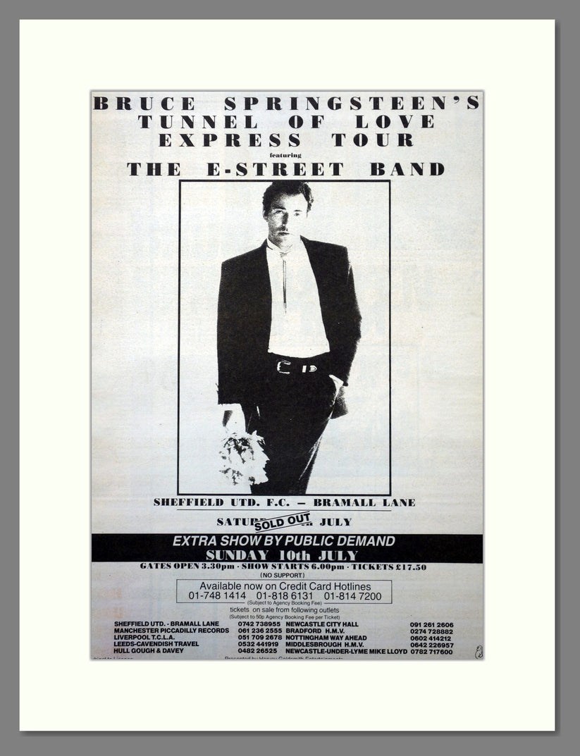
Yes, it was loud!! Living at Brinsworth at the time, we thought the lad who lived over the back was having a loud party outside while his parents were away on holiday. Then realised it was the Springsteen Concert. It was louder than the Def Leppard Concert at Don Valley Stadium some years later, that after the Sound Check the day before was turned down a few notches. Set List: Tunnel of Love Express Tour Bramall Lane 9th July 1988 https://www.setlist.fm/setlist/bruce-springsteen/1988/bramall-lane-sheffield-england-7bd7b294.html
-
The Coal Viewer and Engine Builder's Practical Companion, by John Curr of Sheffield. Quite a difference in Price! https://www.amazon.co.uk/Viewer-Builders-Practical-Companion-Sheffield/dp/1379973619 https://www.forumauctions.co.uk/61/Curr-John-The-Coal-Viewer-and-Engine-Builder-39s-Practical-Companion-only-edition-Shef/1?view=lot_detail&auction_no=1002 https://www.michaelkemp.co.uk/products/author/JOHN CURR, of Sheffield Or download: https://archive.org/details/bim_eighteenth-century_the-coal-viewer-and-eng_1797
-
Map of the Estate of Samuel Staniforth in the township of Attercliffe-cum-Darnall. 1832. https://www.picturesheffield.com/frontend.php?keywords=Ref_No_increment;EQUALS;arc03905&pos=103&action=zoom&id=100165 Full title: Map of the Estate of Samuel Staniforth in the township of Attercliffe-cum-Darnall made for the purpose of ascertaining the title to the several parts thereof as far as can now be done and shewing what parts thereof were entailed by the will of John Staniforth deceased dated 11th March 1700. The following are marked: Top left: Pale Side Field, Upper New Close, Partridge Flatts, Little Wood Close, Green Meadow, Bashforth Close, Calf Close, Barber Close, Lower New Piece, Long Close and Great Old Cotes. Bottom left: Goose Dole, The Acre, Park Field, Lock Close, Old Town Flatt, Hanging Bank, Bowden Housestead Wood, Hollinhurst, Pingle, Six Acre or Rodger Close, Black Hedge, Stone Delf, Ash Close, Two Part Field, Hibberd Field, Owler Greave Close, an allotment, Pease Field, Croft, Near Turner Corft, Far Turner Croft, Near Town Field Close, Turners Flatt, Little Close, Stoop Gate Field, Cockers oak, Great Kirk Bridge. Also shows road from Worksop. Top right: Cow Pasture Tongue, Spring Field, Cow Pasture, Dickawood Close, Stacye Field, Straw Mill Close, Nicholson Croft, Little Town Field, an allotment, Darnall to Sheffield Road Bottom right: Makin Croft, Pit Hill Close, Darnall Hall. Plan of a Freehold Estate at or near Darnal [Darnall] purchased by Samuel Staniforth of Ibbotson Walker. 1839. https://www.picturesheffield.com/frontend.php?keywords=Ref_No_increment;EQUALS;arc03940&pos=10&action=zoom&id=101830 Includes: Little Park Field, Great Park Field or Three Part Field, Green Lane, New Close, Owler Greave Close or Please Land Close, Lock Close, Long Close, Broom Close or Hanging Bank, Far Ley Lands, Near Ley Lands, Broom Close or Hanging Bank, Winter Croft. Land owners include: Church Burgesses and William Deakin. Surveyor: J. Fairbank and Son. Made from the survey made at the time of the Inclosure. The following map fills in some of the gaps on Staniforths map dated 1832. A Map of an Estate in Darnall in the Parish of Sheffield, the property of John Smelter. 1813. https://www.picturesheffield.com/frontend.php?keywords=Ref_No_increment;EQUALS;arc03936&pos=11&action=zoom&id=101852 Includes reference to: Acres Hill Close, Stone Delves, Hollinhurst, Pellet Sick, Bottoms, Footway Field, Rough Close, Little Old Cotes, Horse Pasture, The Acre, Croft, Barn, Stables, stackyard and garden, houses and gardens, allotment on Owler Greave. Samuel Staniforth is mentioned several times as a landowner.
-
The only Smith listed on Stubbin Lane, 1957 and 1965, Mrs. Emma L Smith, at 98 Stubbin Lane.
-
I also left home in 1965 to get married. We had bought a house off Elm Lane at Lane Top . “Aunt Gladys” and her sister ran the Mikado Drink Shop. I put a piece on here a while ago reminiscing about the place…the home made ice lollies and the back room where invited kids were invited to watch TV…….when TVs were a rarity!
-
I left home in 1965 to get married and I expect I remember the greengrocers as Roses on the odd occasion I'd gone shopping with my mum to Firth Park (we lived at Sheffield Lane Top) My sister in law knew Jim Smith and he possibly took over the Bellhouse shop in the mid 1960s? I don't remember a Smiths Greengrocers on Stubbin Lane but do remember the Mikado drink shop where my father took myself and my sister every Saturday afternoon after we had visited Firth Park Library.
-

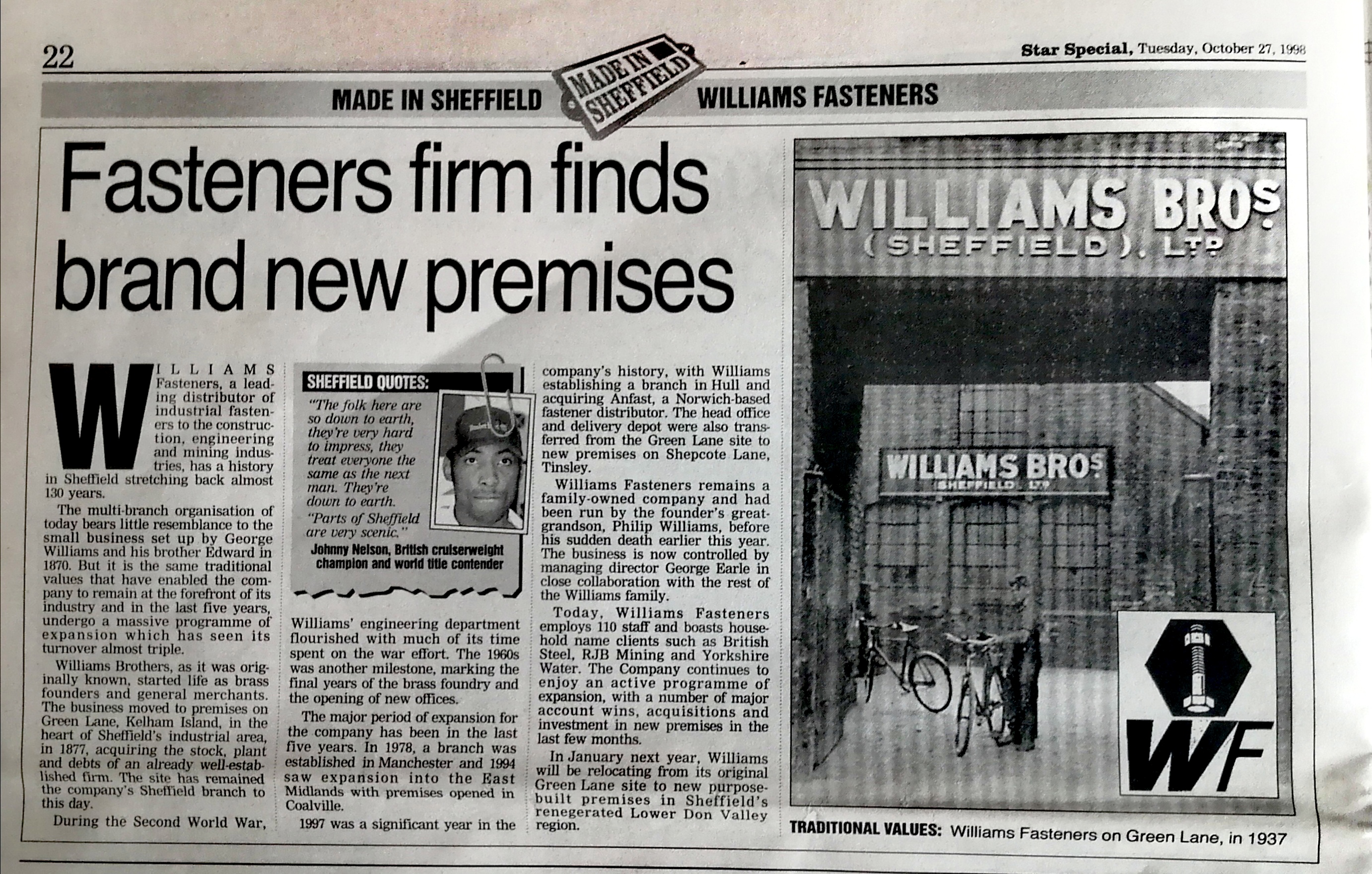
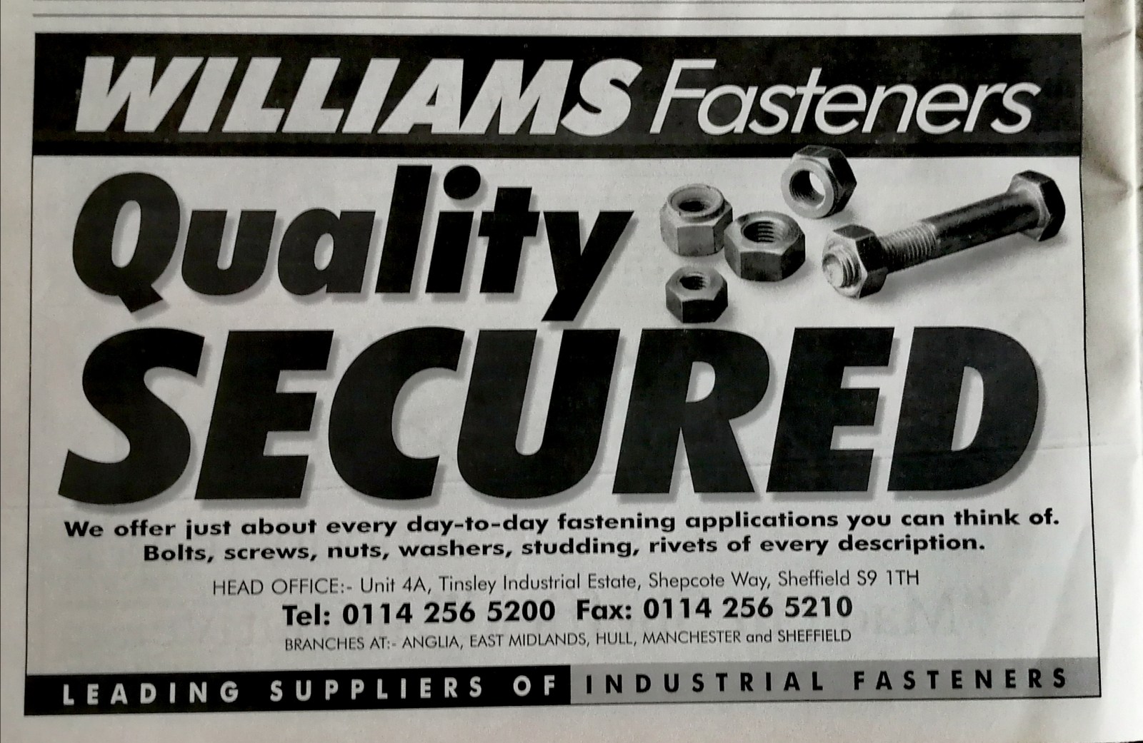
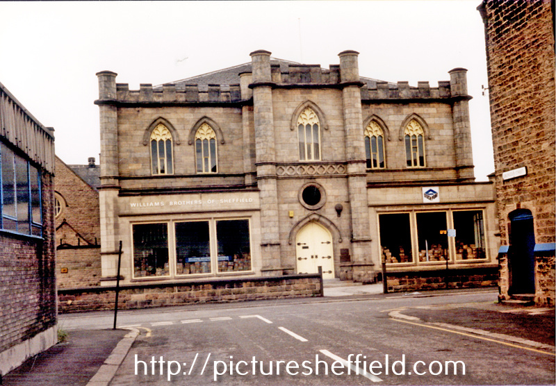
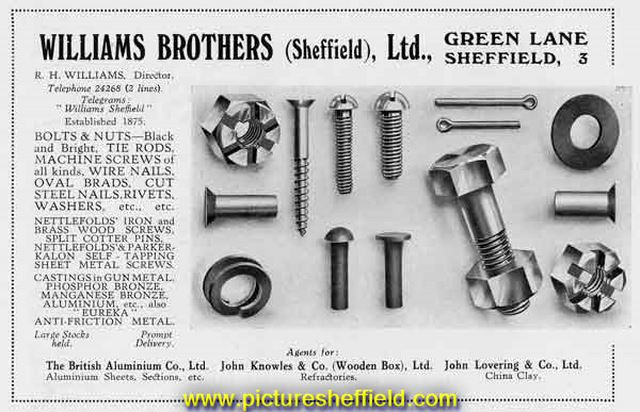
Williams Fasteners, Green Lane formerly Williams Brothers
Ponytail posted a topic in Made In Sheffield
Williams Fasteners formerly Williams Brothers, Star Special, Made in Sheffield, Tuesday 27th October 1998. Whites Directory 1879. Williams Brothers, brass founders, merchants and manufacturers of bolts, nuts, screws, nails, steel files, wagon springs, saws and brass casters and agents for John Knowles & Co., crucible &etc clay mnfs. (Burton on Trent) 35 Green Lane. Advertisement from City of Sheffield Commercial Handbook and Illustrated Guide. 1939 y09977 original Local Studies Ref. 914.274 S Former Ebenezer Wesleyan Mission Church South Parade, from Ebenezer Street, occupied by Williams Brother of Sheffield Ltd. 1986. t01072 https://www.picturesheffield.com/frontend.php?keywords=Ref_No_increment;EQUALS;s40651&pos=20&action=zoom&id=119900 https://www.picturesheffield.com/frontend.php?keywords=Ref_No_increment;EQUALS;s40648&pos=19&action=zoom&id=119897 https://www.picturesheffield.com/frontend.php?keywords=Ref_No_increment;EQUALS;s40647&pos=18&action=zoom&id=119895 https://www.picturesheffield.com/frontend.php?keywords=Ref_No_increment;EQUALS;a03275&pos=8&action=zoom&id=138021 https://www.picturesheffield.com/frontend.php?keywords=Ref_No_increment;EQUALS;t10498&pos=7&action=zoom&id=132806 https://www.gracesguide.co.uk/Williams_Brothers History of Williams Fasteners formerly Williams Brothers. https://rocketreach.co/williams-fasteners-profile_b573da6ff98e1382
-
Snaithing Grange, Snaithing Lane Ranmoor. Built 1897-1904, by Sir Samuel Osborn, steel maker and engineering tool manufacturer. s37774 Images from May 1989 more Images on Picture Sheffield Website. s33539 s33526 s33536 s37800 Link to Estate Agents Brochure: https://www.bpestates.co.uk/buy/snaithing_grange/ Also more internal images: https://www.examinerlive.co.uk/news/property/gallery/take-look-inside-most-expensive-26402494

-
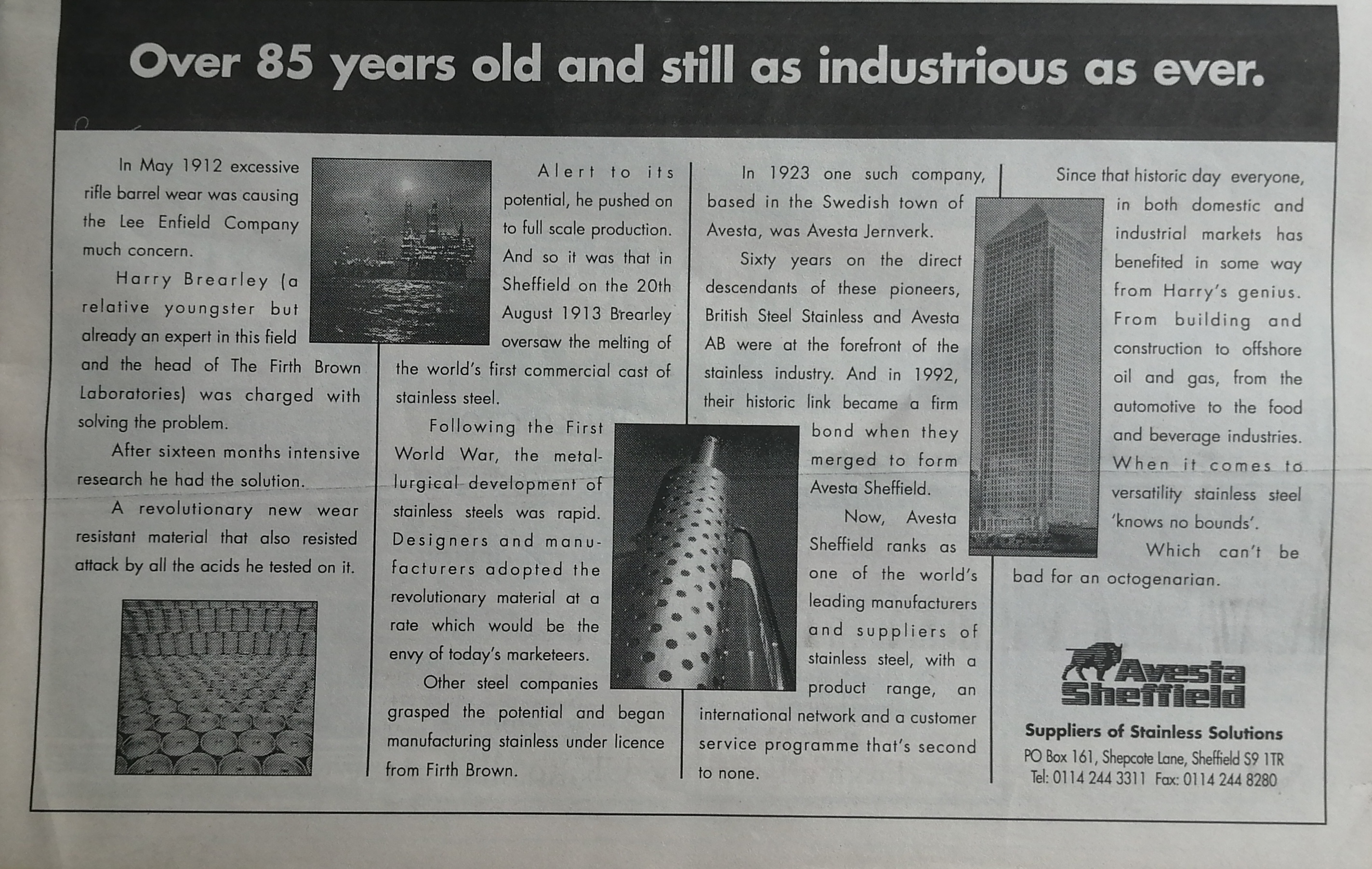
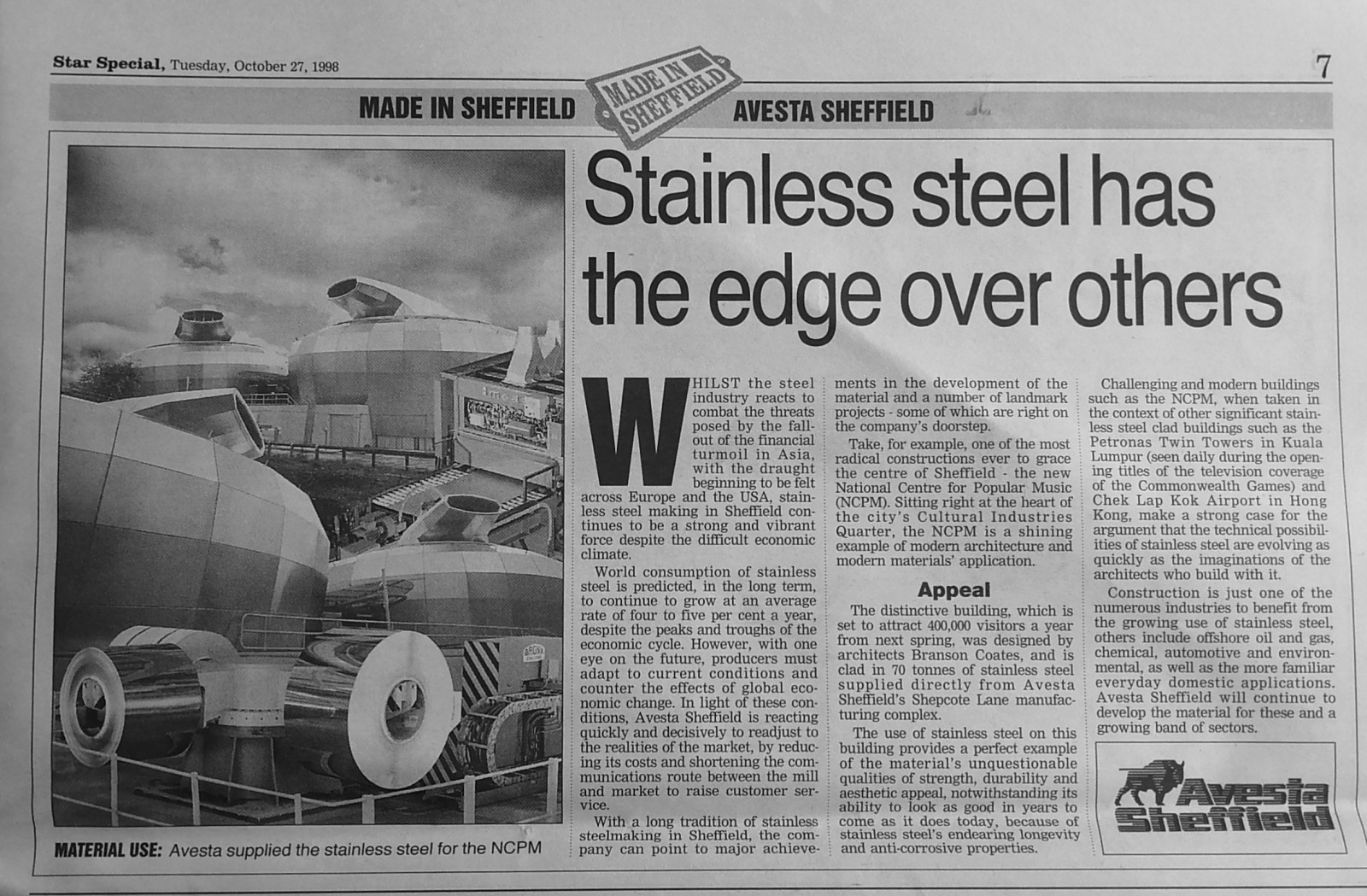
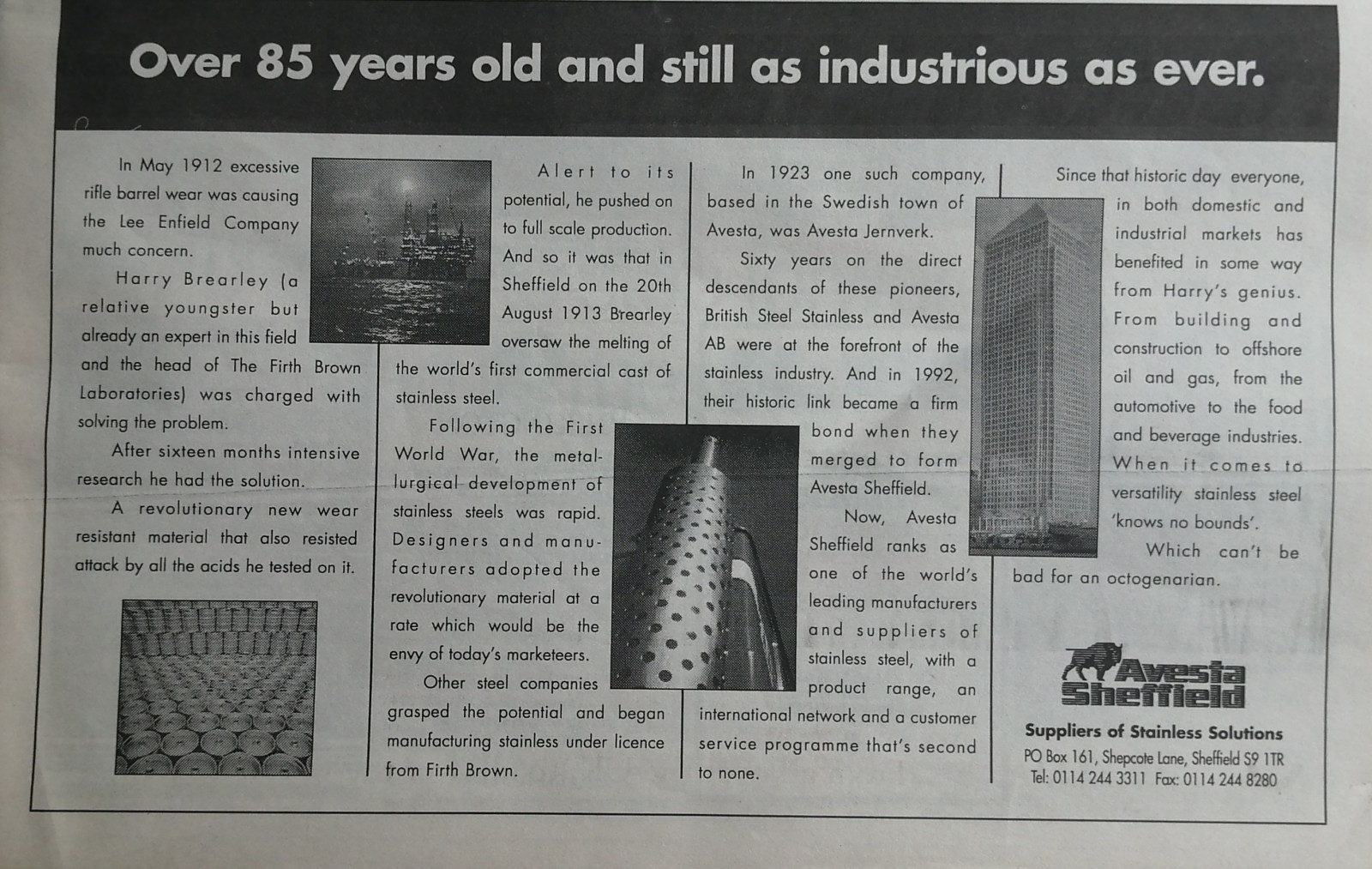
Avesta Sheffield, stainless steel, Shepcote Lane. Article from Star Special, Made in Sheffield, Avesta Sheffield, Tuesday 27th October 1998.
-
Dixon Lane, bridge over the river.
Ponytail replied to Roger Stevenson's topic in Sheffield History Chat
Plan of part of the town of Sheffield, comprising the site of the present and proposed corn, hay and cattle markets, also various improvements connected with the latter. 1827. https://www.picturesheffield.com/frontend.php?keywords=Ref_No_increment;EQUALS;arc04183&pos=13&action=zoom&id=104936 With illustrations of proposed Corn Exchange, elevation of the houses fronting the new Hay Market, and an elevation of the bridge over the Dun [Don]. Reference a - proposed corn exchange and office, b - erections on each side of Corn Exchange, c - weighing machine, d - row of shops. Inns in the immediate vicinity of the present Hay and Corn Markets 1 George, 2 King’s Head, 3 Angel, 4 Commercial, 5 Yellow Lion, 6 Tontine, 7 Healeys Hotel. The sites of the present Hay, Corn and Cattle markets are coloured red, and proposed are coloured blue. Other improvements are shown in yellow. Marked are: Market Place, Angel Street, Angel Inn, old corn market, King Street, post office, Change Alley, Kings Head, Fruit Market, Market Street, Norfolk Street, John Street, Commercial Inn, Hay Market, Yellow Lion, Pond Lane, Shude Hill, Fish Market, Dixon Lane, Tontine Inn, Castle Folds, Castle Hill, Healeys Hotel, Sheaf Bridge, River Sheaf, canal bridge, proposed Hay market, proposed Corn Market, Broad Street, Canal Basin, Canal Warehouse, market for fat cattle, lean cattle and milch cows, pig market, sheep market, River Dun [River Don], Willey Street, Blonck Street, Wicker, Cattle Market, Ladys Bridge, Bridge Street, Wain Gate, Town Hall, Killing Shambles and Castle Street. Plan of part of the town of Sheffield showing the existing markets, the property of His Grace the Duke of Norfolk, and the projected improvements. 1847. https://www.picturesheffield.com/frontend.php?keywords=Ref_No_increment;EQUALS;arc04187&pos=14&action=zoom&id=104946 Marked: Change Alley, Norfolk Street, Bakers Hill, Pond Lane, Market Street, Shude Hill, present Shambles, King Street, Old Hay Market, Angel Street, Post Office, Castle Street, Snig Hill, Town Hall, Waingate, Killing Shambles, Castle Hill, Castle Folds, Dixon Lane, proposed market [Norfolk Market Hall], River Sheaf, new market ground, fountain, Corn Market, Broad Street, Hay Market, Exchange Street, canal warehouse, Canal Wharf, Canal Basin, Blast Furnace Road, Sheaf Works, Wharf Street, Effingham Street, Maltravers Street, fair ground [fairground], cattle market, River Don, reservoir, Willey Street, Blonk Street, Wicker, Nursery Street, Wicker Lane, Stanley Street, Stanley Lane, Andrew Street, Johnson Street, Walker Street, Manchester Sheffield and Lincolnshire Railway, Midland Railway Station [Wicker Railway Station] and railway station [Bridgehouses Station]. -
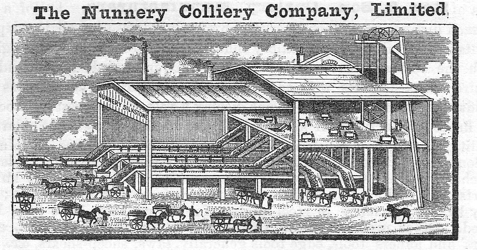
From "The Century's Progress" 1893. For some reason the book is available on a cat enthusiast website, well OCR'd and with engravings. It covers many smaller business's in Sheffield, often in some detail. Link: 1893 The Century's Progress - Yorkshire Unquestionably one of the most important commercial institutions of Sheffield is the Nunnery Colliery Company, Limited, which supplies most of the public institutions of the town with coal, and also, directly or indirectly, provides at least one half of the inhabitants. The business was originally established in 1868. The Nunnery Colliery was formerly the sole property of the Duke of Norfolk, under whom it was worked until seventeen years ago, when a number of capitalists succeeded in converting it into a limited liability company. The managing director is Mr. Emerson Bainbridge, J.P., a gentleman who is well known and held in high estimation throughout a wide commercial circle. Mr. William Black is the secretary. The head offices at Corn Exchange Buildings are handsomely appointed, with a spacious board- room and private rooms for the heads of the several departments. A large clerical staff is provided with all the modern appliances for the rapid transaction of a large amount of commercial correspondence and other business. The Company have a branch office at 58, West Street, and also offices in London. They have also fine depots in Sheffield, which are known respectively as Soap House, in Blast Lane; Salmon Pastures, in Attercliffe Road; Nunnery, in Woodbourn Road and Cricket Road, to all of which the Company have their private line of railways; Manor Pit, within a stone’s throw of the old Manor Castle; Woodthorpe Pit, in Intake Road. There are, likewise, two additional depots, one at Heeley Station, on the Midland Railway, and the other at Wadsley Bridge, on the Manchester, Sheffield, and Lincolnshire Railway. The Nunnery Colliery Company are producing Silkstone and Parkgate coal at the Silkstone, Parkgate, Manor, and Woodthorpe pits, which are all situated in the neighbourhood of Sheffield. The output of these pits is about seventeen hundred tons per day. As they are raising the Silkstone coal at three different pits, they are enabled to guarantee promptitude in the execution of orders for this favourite fuel. They also manufacture upwards of two hundred tons per day of the finest washed steel melting coke, for which they have a large demand in Sheffield for crucible steel melting, where it is held in very high esteem. In the large stables and stable yards of the Company there is accommodation for from eighty to one hundred horses and carts. All these vehicles are in constant use, and the Company are, therefore, able to supply coal direct from the pits to the cellars of their customers. The saving which is thus effected by dispensing with the usual charges for railway carriage and hire of wagons enables the Company to deliver coals at the lowest possible prices. A large amount of money has recently been spent by the Company in providing the most complete mechanical arrangements for thoroughly picking and cleaning the coal. The coal is tipped over vibrating riddles, by means of which the small coal is entirely separated from the large. The large coal is carried slowly by belts into carts and railway trucks, and all impurities are picked out by a number of men and boys placed on the two sides of the belts. The management of this great business in all its departments is most energetic, and all its details, industrial as well as commercial, are constantly under the personal supervision of the managing director and the secretary. The Company contemplate sinking two new pits to the Silkstone and Parkgate seams, in the neighbourhood of Darnell, at an early date, which will very considerably increase the already large output of both house and manufacturing coal.
-
Plan of the Storth Crescent Estate as laid out in building allotments.1862. Marked: Water Lane; Graham Road; Upper Ranmoor Road; Ranmoor; Gladstone Road; Jenkins Lane; Chantrey Road (added Fulwood Road); Nether Green Lane; Nether Green; Brook; Mr. John Hill; Mark Firth Esq; H. Hutchinson Esq; F. Hobson; John Hallam; Mr. W.H. Eadon; https://www.picturesheffield.com/frontend.php?keywords=Ref_No_increment;EQUALS;y10783&pos=12&action=zoom&id=72969 S .F. Holmes, Surveyor, Sheffield. Original at Sheffield Local Studies Library: Sale Plans 1862.
-
Further to the Flood Claim of the properties including naming The Steam Clock and the post for Brightside Lane Houses. The Steam Clock: Searched the Flood Archive with "Brightside Lane" Publicans: James Ellis, publican and farmer, Brightside Lane. https://sheffieldfloodclaimsarchive.shu.ac.uk/claimSummary.cfm?claim=3-2659 Thought James Ellis was a possibility until: James Ellis, Farmer & Publican, Midland Hotel, Brightside Lane, Sheffield Injured person: Mrs James Ellis, Landlady, Midland Hotel. https://sheffieldfloodclaimsarchive.shu.ac.uk/claimSummary.cfm?claim=9b-52 If the Building Society didn't own The Steam Clock then this could be The Steam Clock. Robert Laing, publican Record states he is the absolute owner. https://sheffieldfloodclaimsarchive.shu.ac.uk/claimSummary.cfm?claim=5-4517 There are however 14 properties whose address is "Lowe's Buildings" Brightside Lane. The claim on behalf of the Trustees of the Building Society care of Alfred Allott, Prior Court. lists 10 Houses plus 2 houses and shops adjoining a public house known as The Steam Clock. Possibility these are the ones but need to find who was "Lowe". Question still remains: Which one was The Steam Clock? Robert Bailey, Hay and Straw Dealer, of Lowe's Buildings, Brightside Lane. Absolute owner. https://sheffieldfloodclaimsarchive.shu.ac.uk/claimSummary.cfm?claim=4-3928 George Hall, collier. For personal property. https://sheffieldfloodclaimsarchive.shu.ac.uk/claimSummary.cfm?claim=6-5278 Edward Garner, brick layer. For personal property. https://sheffieldfloodclaimsarchive.shu.ac.uk/claimSummary.cfm?claim=6-5280 John Whiteley, labourer. For personal property. https://sheffieldfloodclaimsarchive.shu.ac.uk/claimSummary.cfm?claim=6-5286 John Ward, labourer. For personal property. https://sheffieldfloodclaimsarchive.shu.ac.uk/claimSummary.cfm?claim=6-5287 John Wright, brick maker. For personal property. https://sheffieldfloodclaimsarchive.shu.ac.uk/claimSummary.cfm?claim=6-5553 Aaron Ashmore, hammer drawer. For personal property. https://sheffieldfloodclaimsarchive.shu.ac.uk/claimSummary.cfm?claim=6-5554 John Hammond, brick maker. For personal property. https://sheffieldfloodclaimsarchive.shu.ac.uk/claimSummary.cfm?claim=6-5575 George Wraythby, brick maker. For personal property. https://sheffieldfloodclaimsarchive.shu.ac.uk/claimSummary.cfm?claim=6-5582 Abraham Cutts, labourer. For personal property. https://sheffieldfloodclaimsarchive.shu.ac.uk/claimSummary.cfm?claim=7-5588 Charles Jackson, shop keeper and milk dealer. For personal property. https://sheffieldfloodclaimsarchive.shu.ac.uk/claimSummary.cfm?claim=7-5589 Thorpe Bailey, labourer. For personal property. https://sheffieldfloodclaimsarchive.shu.ac.uk/claimSummary.cfm?claim=7-6229 Richard Shepherd, carpenter. For personal property. https://sheffieldfloodclaimsarchive.shu.ac.uk/claimSummary.cfm?claim=8-6299 Thomas Askworth, brick maker. For personal property. https://sheffieldfloodclaimsarchive.shu.ac.uk/claimSummary.cfm?claim=8-6317
-

Clarity Lack, "Lustre Silver" EP Trademark's Owner.
Edmund replied to Kalfred's topic in Made In Sheffield
Frederick Green and Sons were at 84 Bridge street in September 1895, Henry Brooksbank was the manager there, advertising for a youth about 17 years old, used to filing spoons and forks. In June 1896 Greens wanted a girl for polishing and wrapping, and were at the London Works, 7 Eyre Lane - still there in May 1900 when the works were advertised to let . (From 1862 to 1895 7 Eyre Lane had been occupied by Briddon Brothers, silversmiths). -
Hi, I am looking for photos of Water Lane, Sheffield. Preferably around the period 1860 -1900, I would be most grateful for any information. Many Thanks Anthony
-
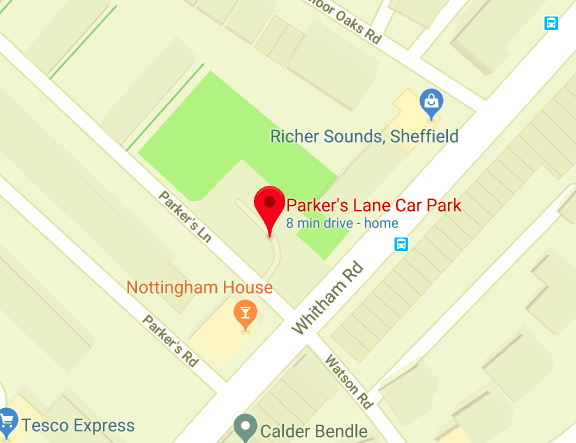
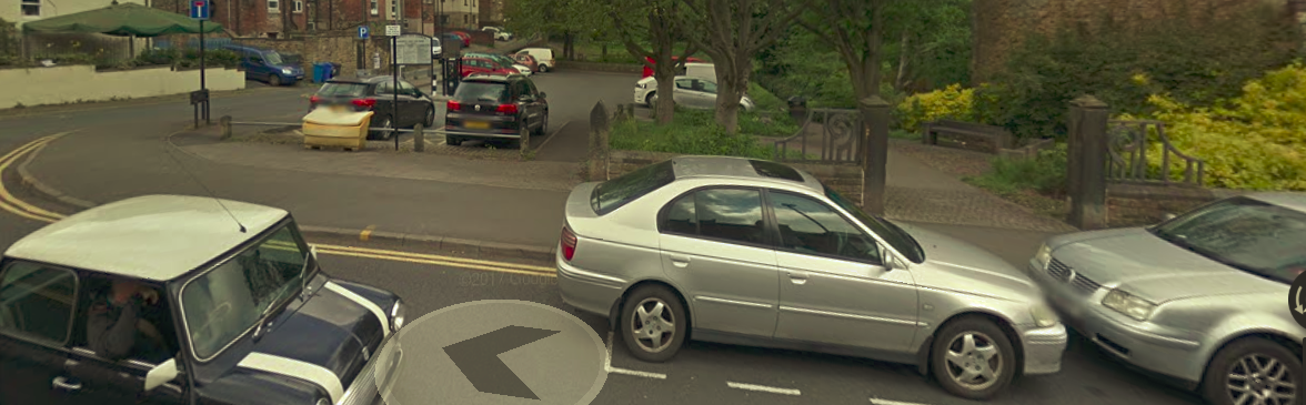
Parker's Lane car park, which is on the corner of Whitham Rd and Parker's Lane, to the right of the Nottingham House pub, also has an area of grass with mini stone terracing for sitting on (I presume). There are also garden gateposts (see pic) with fairly recent railings with inlays which have various items embedded such as open razor, fork etc. Does anyone have any info on all or parts of this site ? If the gates led to a house it would be approximately numbered between 160-140 Whitham Rd. Cheers.
-
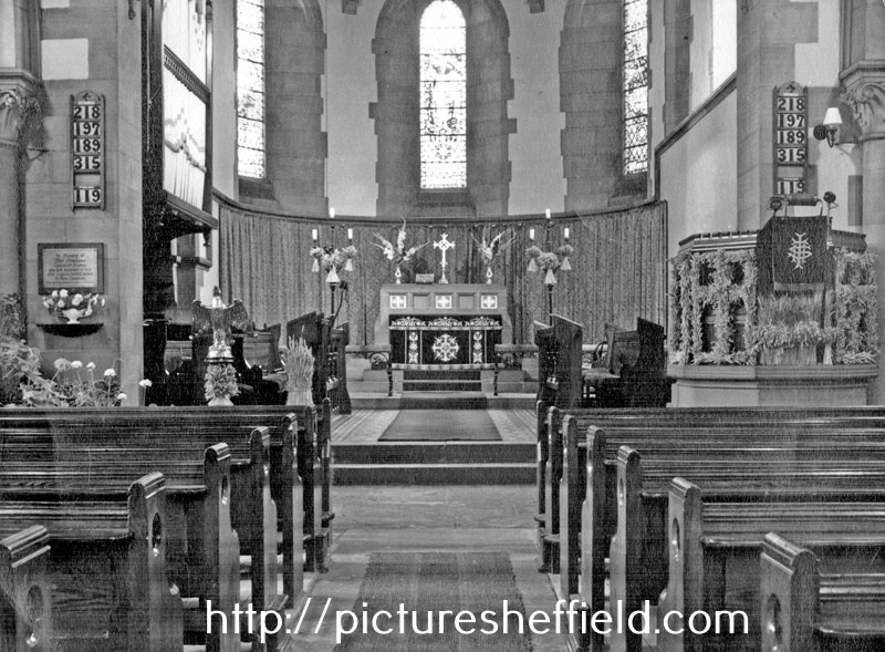
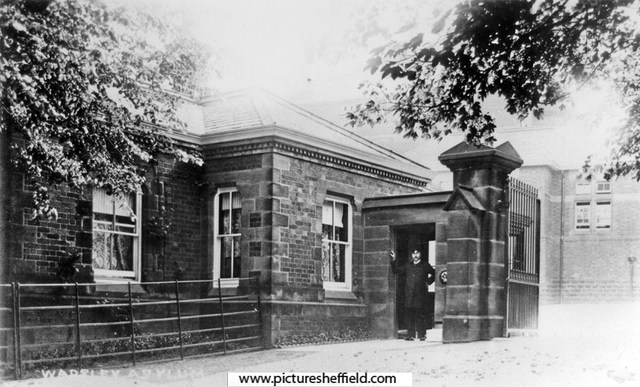
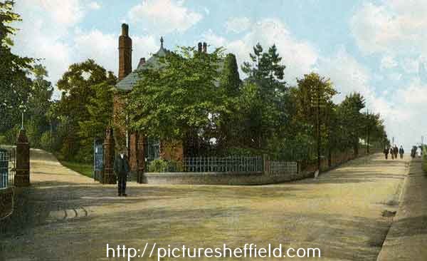
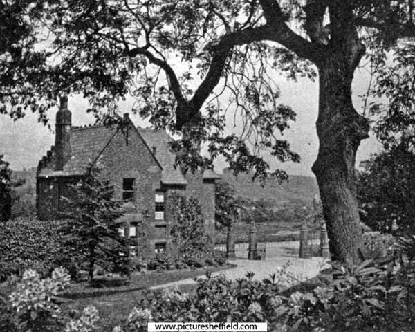
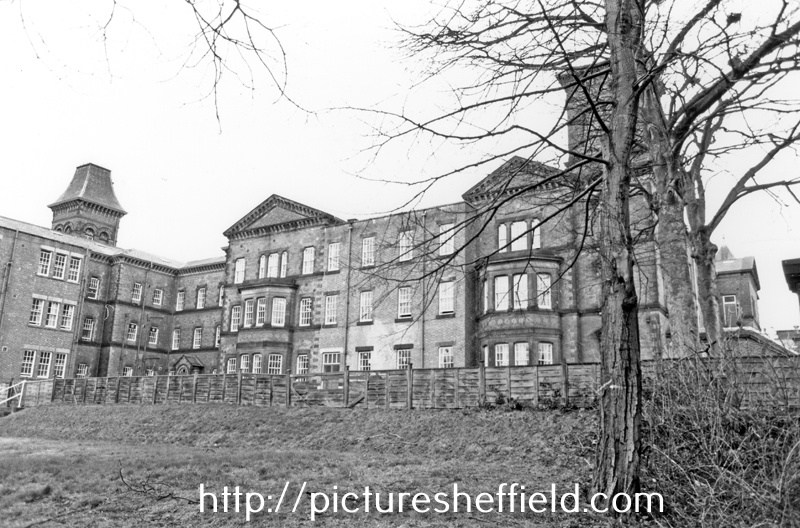
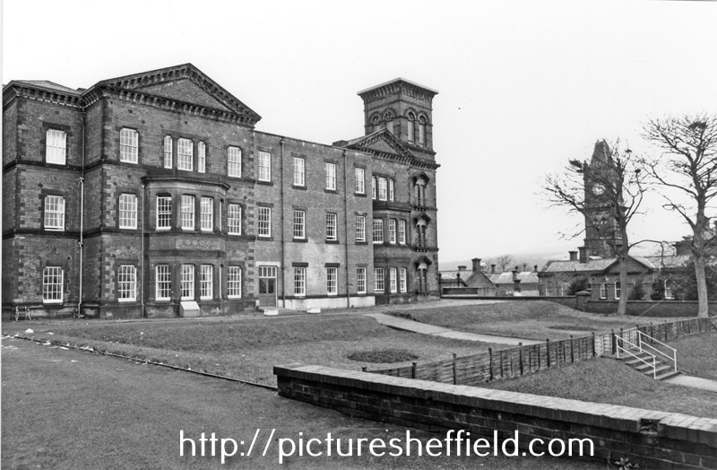
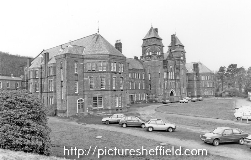
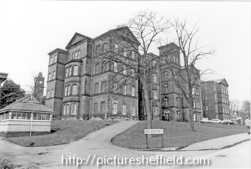
Built in 1872 as South Yorkshire Asylum; 1889-1929 The West Riding Asylum, Wadsley; Converted Spring 1915 into Wharncliffe War Hospital; 1930-1948 known as Wadsley Mental Hospital; 1948-1959 Middlewood (Mental) Hospital; 1959-1972 Middlewood (Psychiatric) Hospital. For more information see: Middlewood Hospital 1872-1972, Thorpe. Local Studies Ref: 362. 209 S. South Yorkshire Asylum - Plan of Estate. https://www.picturesheffield.com/frontend.php?keywords=Ref_No_increment;EQUALS;arc01407&pos=7&action=zoom&id=65677 Shows: Hospital Buildings, including Female and Male Wings, Administrative Block, Nurses' Residence, Laundry House and Dining Hall, as well as Airing Courts, Drying Green, Boiler buildings, Wood and Masons' Yards, Farmery, Kitchen Gardens, Isolation Hospitals (2), Church, Nursery, Gardener's Lodge and Entrance Lodge. The extent of the estate shown is bounded by irrigation land and the River Don to the north north east, Worrall Lane to the west south west, land belonging to Elijah Eaton and Mr. Newton to the north, and land belonging to Messrs. Brooke and Sons, the Trustees of George Miller, and Mr. Fowler to the south. Whilst the date of the plan is unclear, the layout of the buildings shown correspond to a period covering approximately 1889-1901. The name West Riding Asylum was used between 1889 and 1929, and it is known that a second dining hall for women, adjacent to the female detached block, was built in 1901. This hall is not shown on the plan. Printed by Pawson and Brailsford, Sheffield. Scale: 1 inch : 22 yards. Four sections pasted together. Original at Sheffield City Archives X71/2/1. Asylum Entrance Gates & Middlewood Road. t08535 The Gate, looking towards Middlewood Road. s05403 Asylum Lodge. s05404 Kingswood Block, Wards 9 - 13, February 1990.s23410 Queenswood Block Wards 25-28 with Clock Tower Administration Block in the background. February 1990.s23414 South Yorkshire Asylum, Wadsley Park- Basement Plan. Feb. 1875. https://www.picturesheffield.com/frontend.php?keywords=Ref_No_increment;EQUALS;arc07350&pos=179&action=zoom&id=106493 Marked: tailor's shop, shoemaker's shop, attendant's rooms, scullery, wc, shoe rooms, dormitories, single room, day room, ashes, coal, lavatory, bath room, dressing rooms, etc. South Yorkshire Asylum - Workshops (boilerhouse, Bakehouse, Brewhouse, Weaving Shed etc.) Plan and Section. 7th Jan. 1871. Architect: Bernard Hartley. https://www.picturesheffield.com/frontend.php?keywords=Ref_No_increment;EQUALS;arc07351&pos=177&action=zoom&id=106489 Marked: smith's shops, boiler house (with boilers), bake house (with ovens), brew house, plumber, weaving shed, joiner's shop, bread store, malt [store], painter, yard, carpenters' shop, timber yard, urinals; bookbinder, upholsterer, hair picking room, mason's shed and old metal [store]. South Yorkshire Asylum - Washhouse, Laundry, etc., Plan and Sections, c.1871. https://www.picturesheffield.com/frontend.php?keywords=Ref_No_increment;EQUALS;arc07352&pos=178&action=zoom&id=106491 Marked: laundry, yard, drying closet, wringing machines, troughs for hand washing, washing wheel, copper, stock for rough clothes, rinser of galvanised iron, W.C.s and urinals, engine, bevel wheels, stone heeping pits, ironing stove, cold air flue, sorting and folding room, office, women's distribution room, hot water cistern proposed over engine house, women's lobby, women's receiving room, men's distribution room, men's lobby, men's receiving room. South Yorkshire Asylum - Laundry Residence Ground Plan, 1884. https://www.picturesheffield.com/frontend.php?keywords=Ref_No_increment;EQUALS;arc07353&pos=181&action=zoom&id=106546 Marked: day room, scullery, kitchen, W.C.s, nurse, buckets, single rooms, dormitory, bath room, dressing room, etc. South Yorkshire Asylum - Laundry Residence Chamber Plan, 1884. https://www.picturesheffield.com/frontend.php?keywords=Ref_No_increment;EQUALS;arc07354&pos=180&action=zoom&id=106541 Marked: dormitory, stores, W.C.s, nurse, single rooms, bed room, and single rooms. South Yorshire Asylum - Male Block, Second Floor, c.1908. https://www.picturesheffield.com/frontend.php?keywords=Ref_No_increment;EQUALS;arc01414&pos=170&action=zoom&id=66496 Proposed Adaptation of Recreation Hall for Cinematograph Entertainments. 1924. https://www.picturesheffield.com/frontend.php?keywords=Ref_No_increment;EQUALS;arc01413&pos=58&action=zoom&id=66495 Proposed Hospital for Tuberculosis Patients. 1925. https://www.picturesheffield.com/frontend.php?keywords=Ref_No_increment;EQUALS;arc01415&pos=59&action=zoom&id=66497 Sanitary Accommodation for Ward 23. 1925 https://www.picturesheffield.com/frontend.php?keywords=Ref_No_increment;EQUALS;arc01410&pos=55&action=zoom&id=65680 Southwood Block Wards 14-24, February 1990.s23409 Ward and Proposed Solarium. Ground Plan & Elevations. 1926 https://www.picturesheffield.com/frontend.php?keywords=Ref_No_increment;EQUALS;arc01419&pos=63&action=zoom&id=66502 Proposed Solarium marked on Estate Plan. 1925. https://www.picturesheffield.com/frontend.php?keywords=Ref_No_increment;EQUALS;arc01412&pos=57&action=zoom&id=66494 Northwood Block, Wards 5 - 8, February 1990. s23413 South Yorkshire Asylum Church Ground Floor Plan showing dimensions and layout of pews to accommodate 631 people. 1873. https://www.picturesheffield.com/frontend.php?keywords=Ref_No_increment;EQUALS;arc01853&pos=175&action=zoom&id=3264 The Asylum Churcht06703 u01197
-
can anybody remember the chippy on Lydgate Lane on the cross roads,next to the Hallamshire pub,best fish/chips for miles