Search the Community
Showing results for 'coal pit lane'.
-
Interesting, I can't quite make out the details on that old HMV Red label on the record in the Phillip Cann sleve, but, judging by the size of the label to the diamater of the disc, and the quarter inch spindle hole lacking a Juke box knock out I guess this is a 78rpm disc. If so it probably predates 1960 and gives some idea how long it is since Phillip Cann traded from Dixon Lane. Some record companies used Coloured labels to indicate the style of music, eg if it was "Parlophone red label" it was Jazz, although most people would be more familiar with pop music, particularly the Beatles, on "Parlophone black label" I don't know what colours HMV used, but even so this is still a nice image of their famous "his Masters Voice" dog and Vitriola phonograph logo.
-
First school was St Vincents, think it was the bottom of Edwards Street. I don't live in Sheffield any more, haven't done for years, but recently went to see what was left of St Vincents.....a very sad sight indeed. derelict school building and church...now a car park for all the 'city workers'. Left St Vincents in 68 to go to Lydgate Lane, which looks exactly as it used to. Went to Tapton Comp, 73-78. Tapton has been totally rebuilt since my day.
-
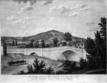
Gramps' post 'Oct 23 2008, 02:42 PM' I know of three, one in the Bellhouse road/Windmill lane area, another on Western Bank and one in Attercliffe. Hi Gramps, returning to the original subject of this thread! Have you seen this print before? If you look closely you can see the windmill at Shiregreen of the horizon to the left. lol
-
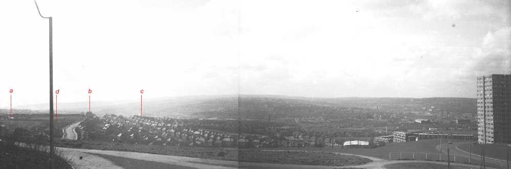
DaveH, You're right , that is Myrtle Road and on the far left at the top of Spur Lane(d) (just this side of the Sports Ground) is Ash Farm(a). On the brow of the hill where Myrtle goes out of sight stands the Ball Inn PH(, Heeley Bank School© can just be seen. My house is also on the view, but I ain't marking it as I don't want you buggers on here coming over and robbing me!
-
Looking at SteveHB's map again reminded me of an old story. Before the Norfolk Park Estate was built and it was farmland. Arbourthorne Road came to an abrupt end where it now meets Park Grange Road (at the current site of the Fellbrigg / Beacon), but it did extend beyond its junction with Fellbrigg Road by a few yards giving the impression that it was going to go somewhere. At the other side of the estate was St. Aidens road which was also a dead end, it ran in from City Road to the edge of the quarry outside Norfolk Park and just stopped, again it went beyond Norfolk Park Avenue, the last road to join it, giving the impression it was going to go on somewhere. The clue is in the original name of St. Aidens Road, - at one time it was called "Arbourthorne Road". was there plans to join the two ends up into an extended Arbourthorne Road which would run directly from City Road to the top of Hurlfield Road? The old story I heard was that as the housing at the St. Aidens end was private and therefore "posh" and at the other end was "council" and therefore a bit rough, the residents on the St. aidens bit objected to it being joined and had the name of their bit altered to "St. Aidens Road" to disown the lower quality Arbourthorne. What a set of snobs! A more likely and realistic reason for not connecting the two halves would have been the route through the Jervis Lum, those 2 small ponds are right in the way and the land which slopes down beyond is that wet boggy area, - not such a good idea then. The prop[osed route would have had to go through the quarry along the Park wall, past the park entrance, follow the route of the current Guildford Avenue a bit but then swing up that steep wet bank above Norfolk Park stream to meet the other Arbourthorne Road by going through those 2 small ponds. When the estate was built, Arbourthorne Road just joined Park Grange Road. I can remember piles of building material being left at its dead end blocking it off for a while, some of it would be used to build the new estate but I bet some of it was used to fill those 2 ponds in. At the other end, St. Aidens Road took a sharp bend up the hill towards Spring Lane and Park Grange Road, to avoid both the quarry and that other piece of unbuilt land the "smouldering tip", an area of land also never built on until recently and for a time used as a football field. This land got its local name because it seemed to consist of mining slag which was always burning.
-
Can anyone remember Phillip Cann (the music man) on Chapel Walk, and before that on Dixon Lane? Yes I can remember Phillip Cann (the music man) went there for a job interview just before I left school. Did not get the job and went to Wigfalls instead.
-
They also seem to have taken some of the street names from them. Truswell (Avenue) and Holme (Lane) stand out among others at first glance. Will study that a little closer and see if I can do a match overlay of the streets. Thanks for the head up Bayleaf. Laurence
-
Residents of a Court, School Lane off Duke Street, Park (1920's) Picture Sheffield
-
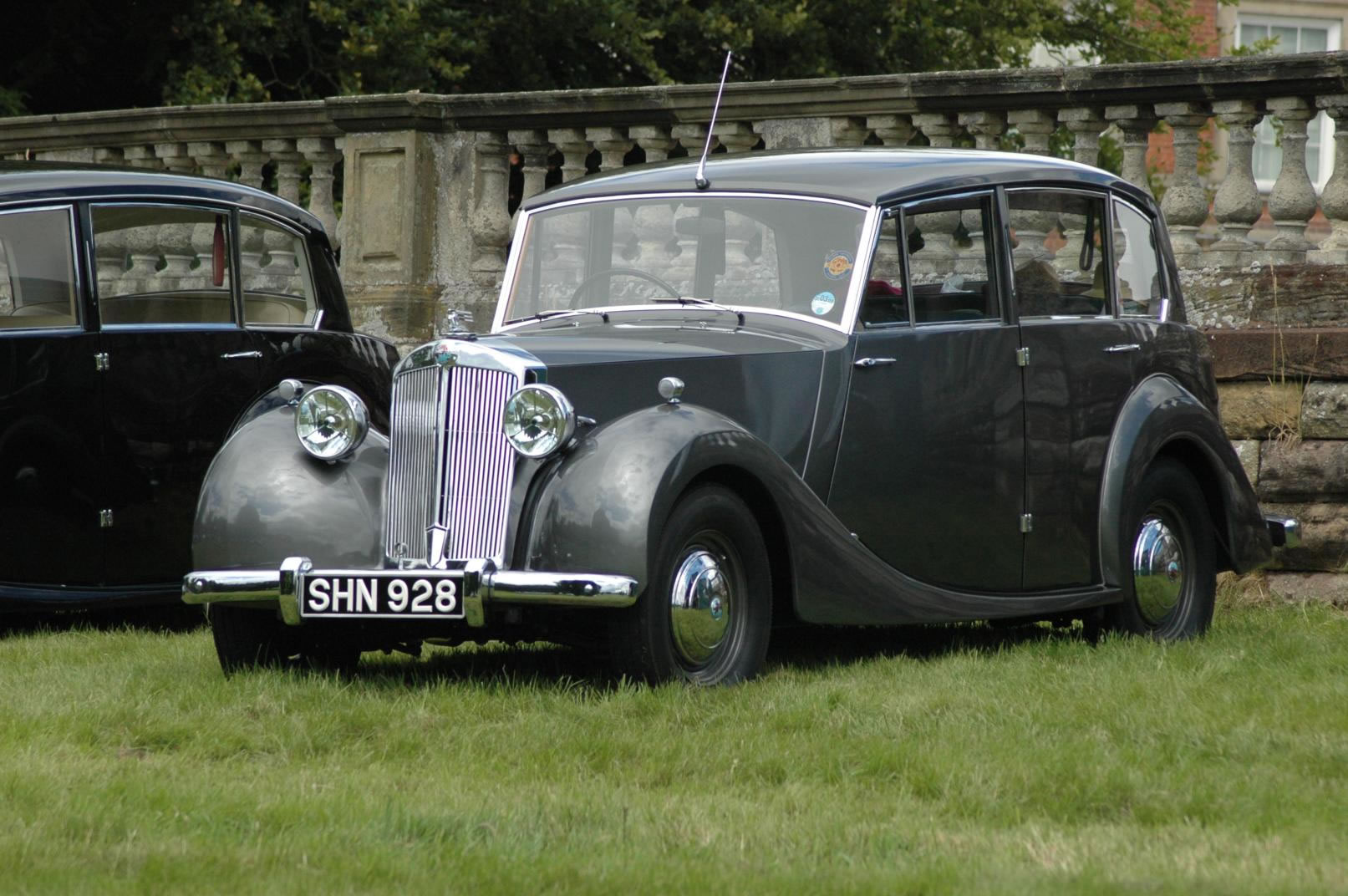
Spent most of this morning trying to think of the name of the bigger brother of the Triumph Mayflower car. Discovered that T.W.Ward bought up Triumph in 1939 and sold it in 1945 without producing a single car. The things you learn on the Net! A friend of the family from Wakefield had a Mayflower and found it couldn't make the climb up Walkley Lane and therefore always drove to Crookes through the town centre. Remember this was pre M1 and his route was through Wortley. (PS. The big brother car was the Triumph Renown)


-
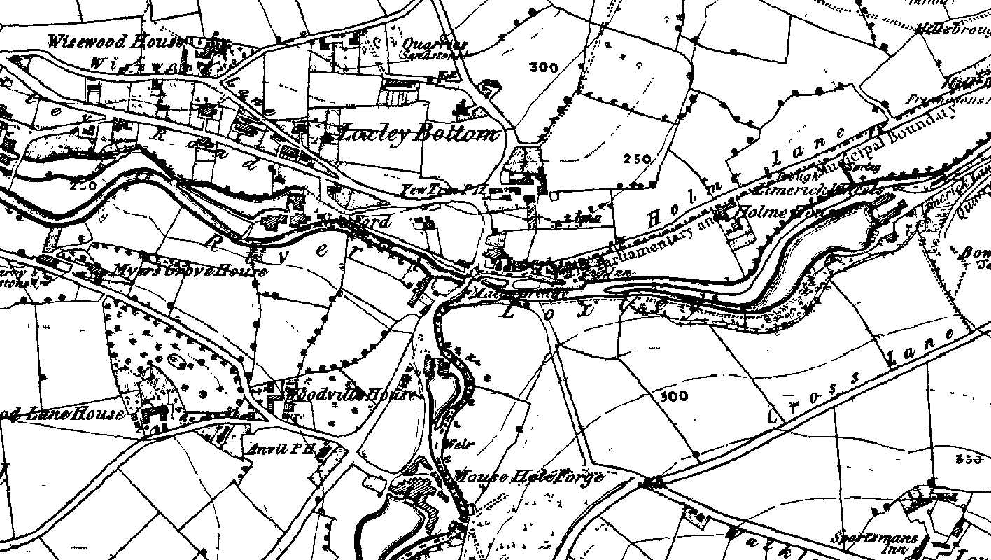
Malin Bridge was a busy little place in the 1850s - lots of dams and waterwheels, some substantial houses, a farm or two and three pubs; the Anvil, the Yew Tree and the Stag Inn. The earliest mention I've found of Malin Bridge as a place is the will of a William Fenton of 'Mallinbrige' dated 5th. May 1578, and another in March 1590-1 for the will of a Nicholas Hobson. Malin was the peculiar Christian name used by the Stacy family for several generations and I read somewhere that there may be a connection between this family and the construction of the first stone bridge here. The waterwheel of the old corn mill on the corner of Stannington road and Holme lane is once again being restored to working order as a condition placed on the developers of the site.

-
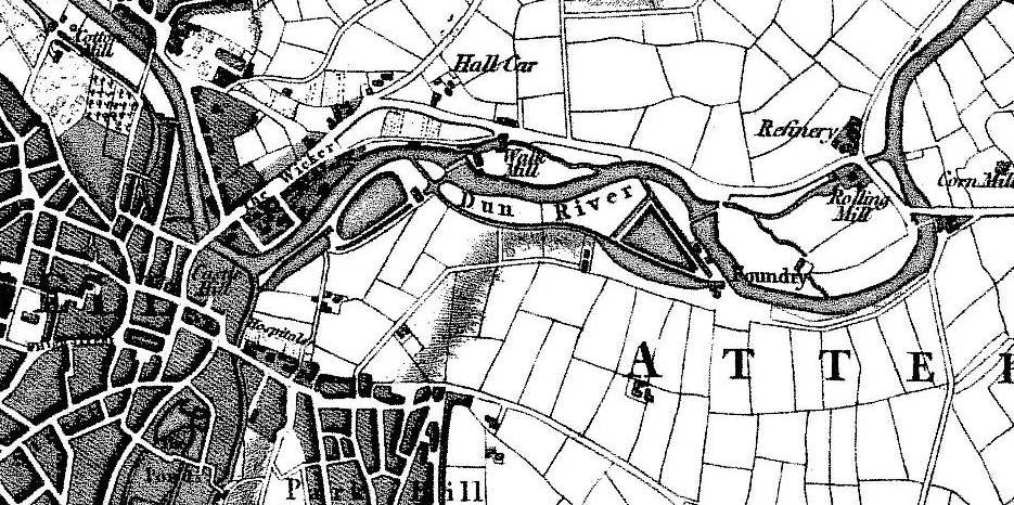
The web site quoted here seems to have been taken down, but a little research suggests that the claim that Lady's bridge was merely a foot bridge is unfounded. The first assertion I've met with that the only approach to the 1485 Lady's Bridge was via steps and that wheeled traffic was forced to use the Sheaf Bridge, is in R.E. Leader's Sheffield in the Eighteenth Century (1905). This claim was repeated by A.L. Armstrong in his account of the excavations of Sheffild Castle and by Charles Drury in his article on Sheffield Castle in the book A Sheaf of Essays by a Sheffield Antiquary (1929). However in his lecture Sheffield's Old Roads, R.E. Leader takes the opposite view and tells us that in 1607 the passage from Rotherham to Sheffield was via Wasford bridge and that the road went "by Royd's Mill to the somewhat higher level of Carlisle Street, past Hall Car and down Spital Hill to the Wicker." He also quotes the account of the chaplain to the Earl of Oxford who travelled from Rotherham to Sheffield in 1725 "Then, after crossing the Don twice more, the first, I think, over Washford, and the next over Lady's Bridge, we get into the town of Sheffield". From an examination of the bridge made in 1909 it was established the the original, dating from 1485 was 14 feet 8 inches wide; qute wide enough to allow two waggons of the period to comfortably pass each other. Why build a bridge of such width if it was intended only for foot traffic ? The steps alluded to appear to have been provided to allow pedestrians access to the bridge from the lane known as 'Underthe-Water' which was eventually replaced by the modern Bridge street. There are other arguments against the case that Lady's Bridge was merely a footbridge; the fact that in the 17th. century the West Riding Justices assumed responsibility for the repair and maintainence of both the Washford and Lady's bridges beacause of their importance as "the common passage betweene Sheffeld and Rotherham and so betweene Yorkshire and Derbyshire in those partes", is one. Another was the annual muster of the Gilbert's private army on 'Sembley Green; many of these men with their arms, armour and their horses would have come in from the west of Sheffield and it seems unlikely that they would have been expected to use the round-about route of the Sheaf bridge and Washford bridge to get to the Wicker. Finally there is no suggestion on Gosling's plan of 1736 that Lady's Bridge was anything other than a road bridge and available for wheeled traffic. As far as is known the bridge at that time had been little altered from its original medieval construction. The alternative routes into Sheffield from Rotherham can be seen on this plan of 1795 by Wm. Fairbank. Ladys bridge has been widened several times. The first was in 1761 when the Almshouses that were formerly the Lady Chapel were also pulled down to widen the approach road. In 1785 the bridge may have again been widened, it was in this year that two properties on the western side of Waingate were purchased and pulled down at the expense of the Burgery, possibly in connection with the construction of the new Bridge street. This wideneing of the bridge may have been in conjuntion with the turnpiking of the road to Wakefield. In 1865 the West Riding Magistrates contributed to a widening of the bridge by 14 feet and in 1909 the bridge was again widened by a further 10 feet. 1761 may also be the date that the Bridge street on Gosling's map was fancifully renamed to Waingate.
-

Bricklayers Arms on Newhall Road and River Don Inn on Brightside Lane
Guest replied to a topic in Sheffield Pubs and WMC's
Sorry my error it was the Brick Makers Arms His name was Robert Guess and he died January 1929 his wife Carrie then moved to the River Don Inn on Brightside Lane and was there until her death in March 1949. After which her son Robert and his sister Ivy, who married my rellie Harold Jeffcock, until 1954/1955 when it was taken over it appears by a John W Whitham. Guess I need to look now at the Brickmakers Arms on the electoral registers to see how long the Guess family were there for! -
I am trying to find more information about the cutlery firms my Great Great Grandfather - Henry Biggin apparently owned. May have been small cottage type industries or larger. According to family stories they are H G Long & Co, I E Sorby, Turner Son and Naylor. Henry had a Electroplate Silver or Silverplate mark of Henry over Biggin & Co over Sheffield. May have existed partly in Bramall Lane as had a mortgaged property there. Henry's wife, Alicia was daughter of James Barber, a Gentleman, who's money was aquired by winning a horse in a gambling game. From being apparently one of the richest men in England, he died in poverty in a Public House in Sheffield. Any information about either family would be greatly received.
-
I've just had a look at the 1950's map of Sheffield posted by Stuart 0742 and SteveHB The one for Norfolk Park has the Jervis Lum woodlands marked but not necessarily in the area we thought. The jervis lum pub was further over towards the area marked black bank, although this is difficult to judge without having Park Grange Road on the map. The woodland itself seems to be a strip outside the actual present day park, a strip of land starting from the bottom of Arbourthorne Road near where the Fellbrigg pub is (was!) running down the hill towards Norfork Park to meet it at the point where other members have commented where the stream / railings and old bridge are at the western side of the park and actually inside its present park boundary. this piece of land, inside the park is the only bit which actually looks like ancient woodland. Interestingly the other bit (opposite the Fellbrigg on the other side of Park Grange Road) never had any houses on it and on the map appears to have 2 small ponds indicating the continuation of the Norfolk Park stream up the hill. Due to wet ground there is very little building over the route of this stream. Its origin must be near Hurlfield Road / Hag Lane which is the highest point. flowing under Hurlfield school fields, East Bank road and a strip of unbuilt land between Errington Avenue and Arbourthorne Road it first emerges to form Arbourthorne Pond just off Eastern Avenue. This drains under Eastern Avenue onto under another unbuilt area, Arbourthorne Playing Fields, forming a boggy patch of land at the side of the Fellbrigg where they built the housing rent office at the bottom of the embankment. It then crosses under Park Grange Road into the never built on area which was the Jervis Lum and had 2 ponds ponds of its own in the 1950's map. The stream finally appears as a proper stream just before entering the park grounds in a steep valley and then makes its way through the park presumably towards the Sheaf. As a young boy living on the Arbourthorne I have memories of running down Arbourthorne playing fields and standing on the top of the embankment just to take in the view with some awe. There was no Norfolk Park estate then (1960 - 64), I was looking at farmland all the way down to the lodge and cottages which stood at the entrance to the Park, a view over the Jervis Lum in fact. Beyond that, with the recent introduction of the clean air act, on a good clear day you could see the city beyond. Unfortunately I was too young to be into photography at the time and I don't suppose anyone had the forsight to take a picture of a view that would soon be lost forever with the building of the new Norfolk Park estate.
-
Richard, Sheaf House was built in 1816 as a private residence....is 1881 the earliest date you have as a licensed premises ? The house had extensive grounds attached which later became the Sheaf House Athletic grounds, and rumour has it that this is where Sheffield Wednesday first formed as a football club. The grounds were subsequently covered by the Bramall lane bus depot.
-
Sawmaker's Arms at 1 Neepsend Lane, Joseph B Williams was the landlord of the Sawmaker's Arm's from 1925-1948. Joseph Williams is an ancestor of mine, and I knew he kept the Sawmaker's, but I don't know a great deal about him. I was wondering if anyone has any information about him other than he was the landlord?
-
Hi me again The Star Rural Lane Wadsley changed it's name to the Wadsley Jack sometime in the 1970s. <_<
-

Bankrupts, Insolvents, Dividends, Murders, Assaults
RichardB replied to RichardB's topic in Sheffield Pubs and WMC's
Petition for Liquidation by Arrangement. W. Dodson Arundell Lane, Sheffield bhk. Liverpool Mercury Wednesday June 9th 1880. -
Bankrupts, Insolvents, Dividends, Murders, Assaults
RichardB replied to RichardB's topic in Sheffield Pubs and WMC's
Bankrupt John G Lane Sheffield bhk. Liverpool Mercury Monday June 23rd 1867. -
Bankrupts, Insolvents, Dividends, Murders, Assaults
RichardB replied to RichardB's topic in Sheffield Pubs and WMC's
Bankrupt J. Lane Sheffield bhk & shopkeeper. Reynold's Newspaper, London Sunday May 15th 1864. -
Bankrupts, Insolvents, Dividends, Murders, Assaults
neddy replied to RichardB's topic in Sheffield Pubs and WMC's
Jul 12 1849 James Yates, brewer to mr Paul Ashley, has lately cut a rhubarb plant of the enormous weight of 7st.5lbs. grown in his garden at Harvest Lane Neepsend. The produce of the same root last year weighed 5st.7lbs.. The plant is three years old.-Sheffield Times. -
There were two Fulwood mills. One has disappeared completely, the remaining part of the other is now the animal sanctuary of Mayfield Rd. They were actually on the May Brook which joins the Porter near the bridge at the bottom of Quiet Lane. The lower mill was demolished and the dam filled in around the 60's I think. The dam for the upper mill is still there but heavily silted up and overgrown. The upper mill was a corn mill. In David Crossley's book Water Power on the Sheffield Rivers he gives the folllowing re Fulwood Mills: "In 1804 the Rev. Smith sold the freehold (with the Woodhouses still named as occupiers) to Samuel Andrew of Broomhall Mill, who in turn mortgaged it to Martha Hargrave. Andrew himself was named as miller in the 1814-15 directory" And Broomhall Mill: "By 1778 Samuel Andrew was at the mill, appearing in a rental and paying £26 5s per half-year; further rentals of 1797-1810 have him still as tenant at the same outlay. He is also named in the 1794 printed list. Another Fairbank survey of 1818 coincides with Andrew's purchase of the freehold and immediate mortgage of the mill, followed some months later by a deed of appointment of trustees, suggesting Andrew may have been in failing health." There are some good colour plans of both mills in the book, but they're from the Sheffield Archives and I wouldn't like to upset them by posting them here! There's a lot more detail in the book, it would be worth a look.
-
Joins Mowbray Street, Neepsend Lane cuts across it.
-
For anyone who has'nt come across him before, Ron Sandersons site has some brilliant black and white photos of old Sheffield. Here: http://www.ronsandersoncollection.com/photo-galleries.asp Borrowed from his site, Dixon Lane, no sign of Big Ada though. Some nice ones of the "Rag 'n Tag on there too.
-
<br /><br /><br /> Hi Gramps Yes the Hall Carr on Carwood lane did become a popular pub round about the 60ties l believe but not so much in the days of my early years of living round that area in the 30/40 ties The house you named St Andrews vicarage, was in my time ocoupied by seve ral families l remember it was something of a religious connection very run down but l never knew it's name, although iv'e been in it, the next building as you say was a parish hall, but l forgot for a minuite, in between S A V And Carwood rd new a small private houses estate named Rothay rd estate was just being built , the next came the Hall and behind it the house you could not see much of its entrance being round the corner on Sedan st. housed the Rev Vicar of All Saints Church Mr Heppenstall Cheers Gramps .Skeets.