Search the Community
Showing results for 'coal pit lane'.
-
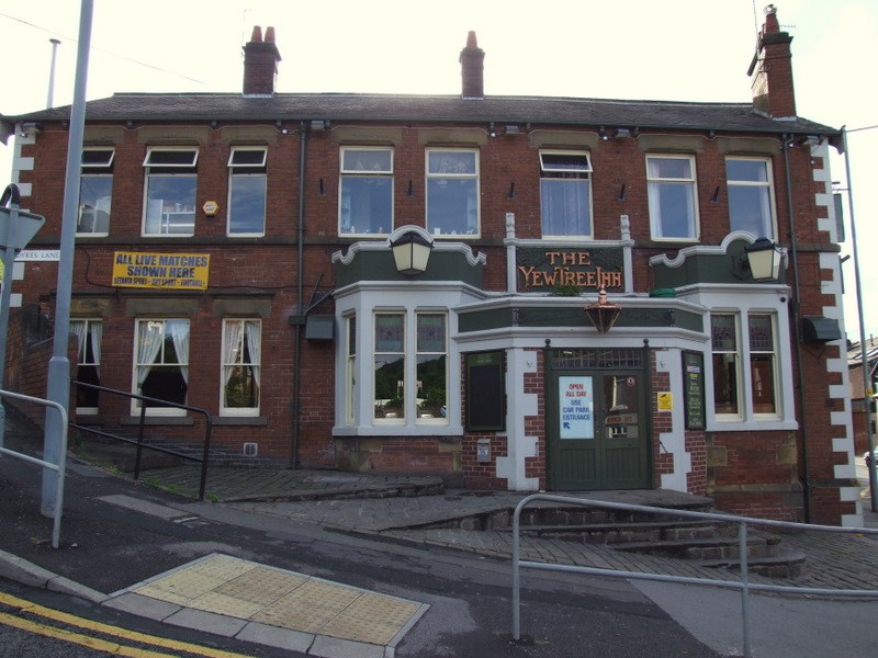
Samuel Binney, Saddle, West Street Joseph Boot, Union Inn, Cherry Tree Hill John Chapman, White Hart, Russell Street Joseph Ellis, The Twelve O'Clock, Saville Street, Brightside Bierlow Robert Bateman, Don Inn, Penistone Road Willian Chapel, Station Inn, White Lane, near Sheffield Robert Barnes, The Clock Tavern, Westbar Green (on existing list as Clock Maker's Arms) Henry Berley, Waggon and Horses, Heeley, near Sheffield Thomas Earnshaw, The Ball, Carver Street George & John Alexander Gill, Club Garden Tavern, Little Sheffield Henry Sampson, Adelphi Hotel, Arundel Street Willian Taylor, Freedom Hill Tavern, Walkley William Tarlington, Scarbro' Arms,Crookes Lane John Wragg, Ball Inn, Lambert Street Jack Wright, Old Ring of Bells, Bottom of Pea Croft
-
Resident, as of July 1865, George Kinder, White House, Brammall Lane. (Double M is intended, not a deliferoot speeling mistook)
-
Unused Card Wagon Label, 5 x 4 inches LNER 1005/10 5,000 4/42 O.6029 From Boston Potatoes To Blast Lane Sheffield L.N.E. Rly G.C. Secn. via Barkstone and Retford

-
http://cgi.ebay.co.uk/THE-STORY-OF-OLD-ATT...p3286.m14.l1318 THE STORY OF OLD ATTERCLIFFE by G.R. VINE This is a rare opportunity to acquire all 8 parts of this scarce title published in 1932 and still in their original covers. They contains a wealth of local history, industry and old family names from the area This is a list of contents from Part 4 The Slitting Mill / The Seaman Family / Intakes / Bacon Lane / Woodbourn Hall / Henry Clifton Sorby / The Canal / The Ottley Memorial / Pinfold Lane to Wharf Yard / Attercliffe's Three Great Fields / Park Field / The Sheffield Coal Company / The Nunnery Colliery / The Woodbourne Hall Picture This is a superb resource for local / family historians with an interest in this area. together they contain 322 pages and are A5 format In vgc --------------------- Currently £95 and no, I'm not bidding
-
People in Sheffield must be beginning to wonder why there is such a sudden interest in railway arches and the compulsion for people (paper in hand to compare) to take photos, perhaps its time to pool our resources, if only to save fuel. I've already visited and discounted Neepsend, Attercliffe (Worksop Road), Wadsley Bridge, Chapeltown, Grange Lane (Lower Shiregreen), Tyler Street (all stone bridges) and most recently Brightside Lane jcn. Weedon Street, a brick bridge but not the one!. I've searched the Picture Post (online), no luck ....... scoured Picture Post books in the Reference Library, I may have to start getting serious soon, if my sanity lasts! ........ I am sure we will all bump into each other, literally, quite soon. I am open to suggestions ..... please!
-
... The lower part abounds, however, in confined courts, filthy dwellings, and the most depraved part of the population. To persons at all acquianted with the town, in corroboration of these remarks, it is sufficient to name Castle-green, Water-lane, Scargill-croft, New-street, Red-croft and many of the courts and bye lanes in the vicinity; Holly-street Bailey-field - a street about 150 yards in length, and yet containing more than 40 workshops and 192 houses, 134 of which are in close and unhealthy courts, and many of them occupied by the lowest class of artisans and Irish. They are the resort of thieves and prostitutes. Taking the inhabitants of Bailey-street at five per house, which is greatly beneath the truth in property of this description, and allowing merely one person for each workshop, the population of this street only is 1000. (1) (1) There is no Public sewer in Bailey-field, and most of the court yards are below the level of the street. The street however is well paved.
-
25th July 2008 to 26th July 2008 Trippets Champagne and Wine Bar Trippet Lane Sheffield S1 4EL Phone: 0114 272 7928 http://www.eventsheffield.co.uk/event/3331...e-bar-live-band
-
I seem to be taking a lot of photo,s lately of old Sheffield Works. The other day I was on Blast Lane and came across the Sipelia Works. In it is a commune for the homeless. Their shop is well worth a visit but they also have a potted history of the site. http://www.emmaus-sheffield.org.uk/2.html
-

Huddersfield Town map for Nazi invasion.
mickjj replied to syrup's topic in Non Sheffield General History
I guess he must have been an Owls fan then as Hillsborough was not touched wheras as Bramall Lane took a direct hit. lol -
That's what I'm thinking with the Bass lorry and I think that is Sheffield number 1 signal box. The bridge in the distance would cross over Rutland Road. Here's a photo from my book courtesy of E M Johnson: Woodhead - The Electic Railway, Foxline, undated. Note the grassy hill in the distance, it looks the same. The only thing I'm concerned about is that the coal shoot arches - I believe that's what they are - they definately were and still are just up from Neepsend Station, is the fact that the bridge abuttments appear to be stone in EM Johnson's book but brick in the photo you provided. Modernisation after the Woodhead upgrade in 1954?
-
I don't know if this will help, but by 1849 the Columbia Works was owned by Marsh & Shepherd: 1849 Steel Converters and Refiners Marshes & Shepherd, Forge Lane and Columbia Works and also in the 1852 Directory... Marsh Brothers & Co. merchants, & steel, file, saw, edgetool, cutlery, &c. manufacturers, Ponds Works, Forge lane, (steel works, Blast lane, and Columbia Works, Suffolk road) I don't know if John Brown was taken over or moved elsewhere. I can't see him as a razor/knife maker in the 1852 listing. Hugh
-

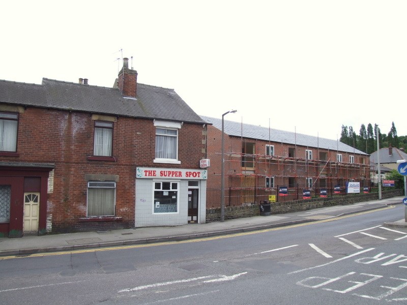
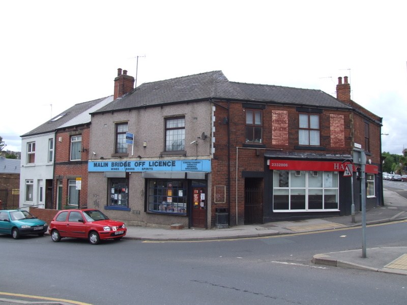
Malin Bridge - Comet/Restaurant/Clothes Shop ?
dr stanley replied to Sheffield History's topic in Sheffield History Chat
Hi wunumpi ...... wadsleyite beat me to it with the photos of the old Comet store but I hope these photos will make up for it. As you can see "supper grot" is still there, though I'm told they're not as nice as they used to be, the name of the steep hill that escaped you is Dykes Lane (very steep indeed). I have one more photo for you but I will send you the link in a private message.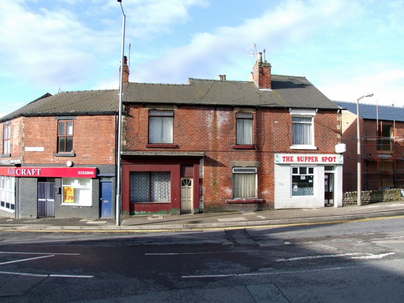
-
I've walked the "The Upper Don Walk" over the last few weeks. I would say its back to its pre flood conditions, its a bit muddy in places especially Club Mill Road but I think thats down to the recent rains. Along the first section from Ladys Bridge to Corporation Street, they've erected some very good information boards, heres the first board: a portion of the above sign Artwork at Corporation Street I walked the final section from Oughtibridge to Claywheels Lane this morning, again a bit on the muddy side but easily passable. At Oughtibridge you can see where the Environment Agency have dredged the river and removed a lot of the bankside trees, they've made a good job! Regards the the bridge at Livesey Street which was washed away, there is a little known alternative foot-bridge across the river, just past the new College and near to the "Power Station", is a footpath which leads to the metal footbridge.


-
Excellent, which one is William please ? The place has the look of Dixon Lane - unless you know differently !
-
Hi everyone, As part of my research at the University of Sheffield - I'm doing some reading into the demolished Western Works on Portobello, which used to lie between Broad Lane and West Street. As I understand it, the building become derelict after a number of years during the 1970's and then become something of a hang out for bands of the era like Cabaret Voltaire - until it was demolished in the late 80s/ early 90s. I would be really interested to hear from anyone who has memories/info on this building. Cheers, Tom
-
Malin Bridge - Comet/Restaurant/Clothes Shop ?
Guest replied to Sheffield History's topic in Sheffield History Chat
HOLY CRAP!! 'scuse my french but I used to live at 146 Loxley Rd - we overlooked the Comet car-park. The supper spot was my favourite chippy. Is it still there? We affectionatley used to call it the 'supper grot'. I ran 2 paper rounds out of the newsagents on the corner for my entire high-school life. I used to go down the river on a tyre inner tube and loved dropping over the litte waterfalls. I think I remember Comet closing down, but I left there in 85 and haven't been back since. I used to catch teh bus into town from the shelter beside the Yew Tree and my best mate lived just up the hill on the bend....I can't even remember the name of the road but we used to walk it every day to get to malin Bridge Junior School, and sledge down it in winter. I hope you manage to get some more photos. I never realised how much I miss the place. Thanks for the walk down memory lane -
i grew up on bolsover road. & remember whe page hall was the owned by the coal board & was flats or something. that was before it came to be a nursing home. it was a really scary building.
-
Hi Syrup,Thanks for that one,one I haven't seen,there are more on the same site spelt GIN. This one looks like the garden wall,if that is City Road at the top,then this looks like the dog-leg in Stafford Lane. The reason I ask is I was told that the Ginn Stables was where the Duke of Norfolk's pit horses and ponies were stabled,this has some credibility when while searching for old maps i came across one which showed a colliery a bit further up City Road. Around 1945 I was sent every summer holiday from Blackpool to Stafford Lane,my grandfather,George Newton was some sort of manager for the Duke,and lived at the Ginn Stables as part of the job.It was a fascinating place,which would take a few pages. Thanks for the info,i'll add that one to my photo's. Dave in Inskip
-
Firvale Trinity Methodist if I remember right. I ought to know, I was christened there, but don't remember much about it! The church is still there but part of the other buildings (schoolroom?) is now a mosque as you say. I can remember them having kids film nights there on a Friday I think. They stopped just as I was getting old enough to go, but I went with an older cousin once, pretty riotous as I remember! The bit of Owler Lane from Firth Park Road to Rushby Street was always known as 'Store's Hill' in our family, because the 'big' Co-op was there. I lived with my parents and grandparents on Skinnerthorpe Rd and two of my aunties and their families lived in the 2 adjacent houses. They all backed onto a high redbrick wall with broken glass set in the top, which was the backyard wall of the Co-op. I remember getting my hair cut at Charlie Hague's on Rushby Street, and there was a smashing chippie next door where we went every Friday for our tea. On the corner opposite there used to be a herbalist where you go and have draught sarsaparilla from pub-type pumps.
-
This is a photo of a tin church, or tabernacle, as they are known, near us in Lincolnshire - my children go to school in this village. Christ Church, pictured above, is a recent addition to the village, having been erected in 1893, and is one of England's few remaining tin tabernacles, tucked away in a side lane yet still serving the community as a place for worship after more than a century although its construction was an early form of prefabrication, made elsewhere from corrugated iron and erected on site for less than £400. Here's a website dedicated to them. http://www.tintabernacles.com/

-
Anyone any history on the Ginn Stables,Stafford Lane. Dave in Inskip
-
The wife wrote this down at the archives, looks like they moved the former inhabitants to Abbey Lane. Burials Abbey Lane grave plots list re burial St Philip 1967 1160-1166-28th June 1215-1221- July24-25-26-28 1379-1381- 11 Sep 1436-1441- 4-5 Oct
-
Loxley New Rd would place her closest to the tin chapel at Rural Lane Wisewood. I don't remember it, but my wife says it was turned into a little sweet shop directly opposite Wisewood school gates. PS PLEASE....don't suggest a listing for steelworks....Richard might see it and think......! Good luck with rest of the search.
-
I was born on Skinnerthorpe Road just after the war, and we lived there with my grandparents until I was 6 when we were given a council house on the Longley estate. I had relatives there until the early 70's. I remember walks in the allotments where Firvale School is now, and shopping trips meant Banners at Attercliffe rather than town. Every couple of weeks we visited my other grandparents on Clarence Street, and I remember the final bit of the tram ride home in the dark down the steep bit of Barnsley Road with sparks coming from the tracks (brakes?) I started school at Owler Lane Infants, and remember climbing endless stone steps from the Owler Lane entrance to the school entrance.
-
Sorry Hugh, it was St. Timothy's church, not St Thomas's. It was built on land between Slinn St and Bradley St. There were other 'tin chapels around at this time at Wadsley Bridge and, I'm told, around Rural Lane, Wisewood. I've also a feeling that Crookes Baptist Church, off Mulehouse Rd, also started as a tin chapel.