Search the Community
Showing results for 'coal pit lane'.
-
At the bottom of Northern Avenue near its junction with Spring Lane is another entrance close to where the "pavillion" once stood

-
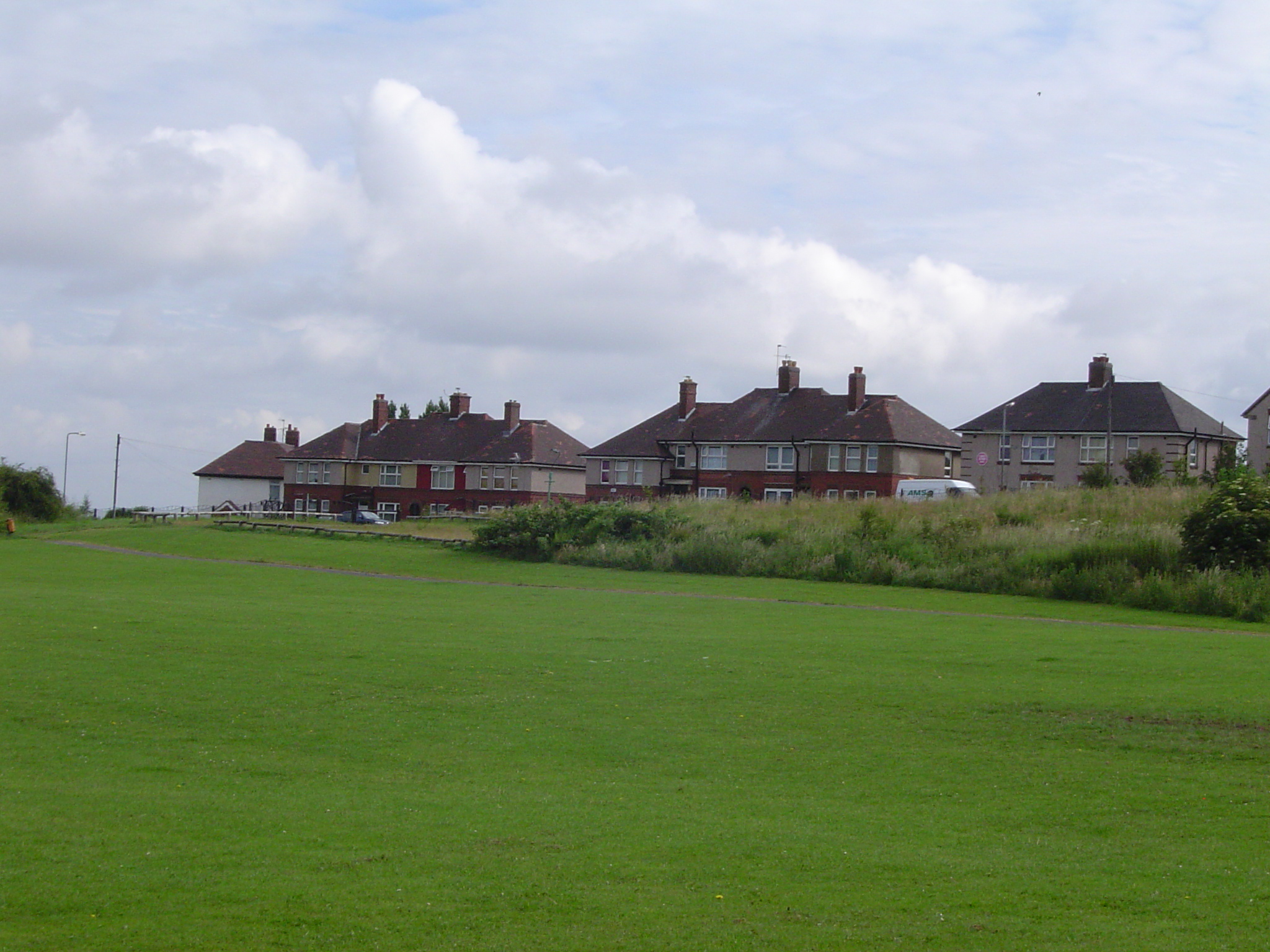
I want to say Edenthorpe Grove or possibly Lundwood but I don't think they are as old as 1979. Wherever it is it's near Camps Bottom. So I'm going to have to say the Bottom of Brook Lane. Not very confident because where I think it actually should be is either too modern or still not built on. :angry:
-
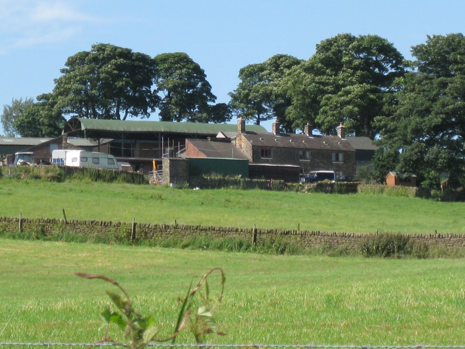
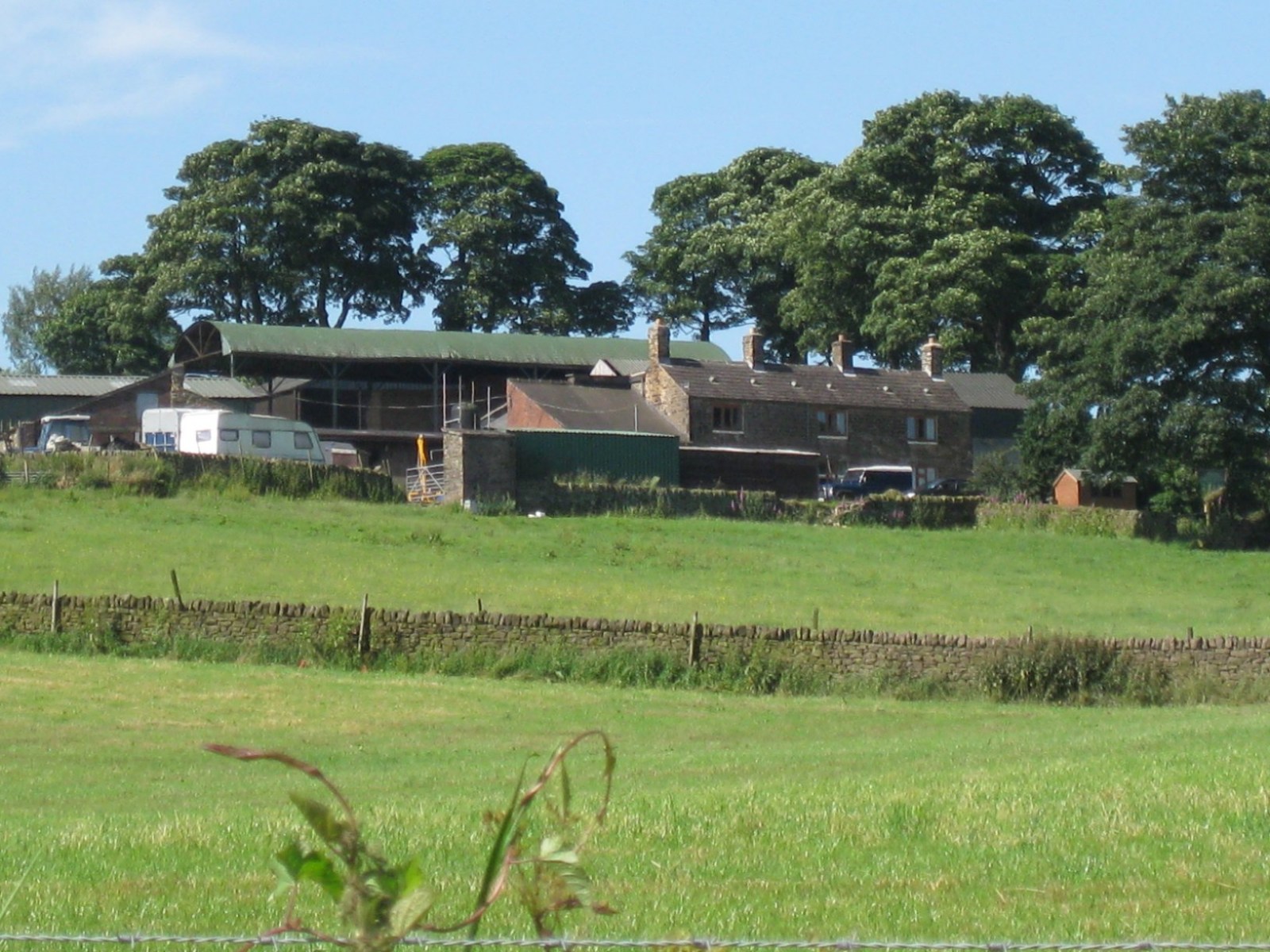
Hi Steve I was up the valley this morning so I took a couple of photos. You'll see they're very different, Green House farm is very much a working farm, one of the few left in the valley. Brownhills on the other hand is very much a private residence. The photo is taken from across the valley, as it can't be seen from Brownhills Lane. Green House farm Brownhills Farm regards Bayleaf

-
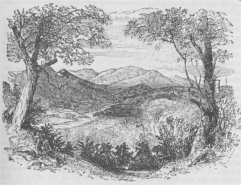
From Pawson & Brailsford's Illustrated guide to Sheffield and Neighbourhood 1862 SHIRECLIFFE. Shirecliffe is a spot as noted in the poetry of Elliott as the Valley of the Rivelin; and equally beautiful. It is, indeed, peculiarly interesting to the admirers of Elliott, as the spot where was situated the "gospel tree," under which "the Ranter," in the poem of that title, went on Sundays to preach. The peculiar title of " gospel tree," is not very appropriate, for the gospel preached in the poem consists principally of a denunciation of the Corn Laws and their supporters, mingled with sweet descriptive touches. Elliott himself stated that he drew this picture from life; and it seems probable that the actual spot described in the poem was once used as a place for preaching. The tree, which unfortunately no longer stands, was an ash; and Elliott drove a nail into it that his friends should be able to recognise it. We shall endeavour to describe the scene as it exists at the present time. First as to the road: The visitor will find an omnibus that will convey him to the Pitsmoor toll-bar, from which it is not more than ten minutes' walk to the spot where the "gospel tree" stood. He turns up Shirecliffe-lane, at the top of which, on the left, are the gates of Shirecliffe Hall, once the seat of the ancient family of the Mounteneys, but now the residence of the Watsons. A little beyond the gates there is a fine view of the adjoining country, reaching out as far as the villages of Handsworth and Laughton-en-le-Morthen. A little further on, to the left, we turn off into a quarry, and a pretty steep ascent leads us to the scene we have set out to visit. Formerly a view of the country on all sides could be obtained from one spot ; but the summit from which this was possible has been cut away in the quarrying operations. To see the whole district, therefore, it is necessary to go to places some little distance apart; and, passing from that where may be seen an expanse of country which includes Hoober Stand and Keppel's Pillar, we come to the principal view, an outline of which is given in the accompanying illustration. It is scarcely possible to imagine a more magnificent sight than is presented in the stretch of country laid out before the gaze. Three distinct ranges of hills undulate in the midst of the landscape, while these again are backed by lofty prominences, which tower up in the far distance, and mingle with their purple hues in the serene blue that is over all. In the middle distance two rivers, bright in the golden sunbeams, gracefully meander through the green fertile earth. Here a church spire rises up through the surrounding foliage ; there a slender bridge spans the placid stream; while yonder a chimney top peeps out through the green trees, the blue smoke curling lazily upwards. In the valley we see a fortress-like building of stone, extending over a wide range of ground; and this is backed by houses rising row above row on the hillside. At our very feet where we stand, a sea of green boughs stretches further than the eye can reach-its varying hues brought out in marked contrast by the bright sunshine, and the gentle, breezy rustling of the leaves mingling harmoniously with the sweet notes of the birds and the busy hum of the short-lived summer fly. The visitor cannot mistake the spot from which this view is to be obtained, in consequence of the very prosaic notice-" No Road"-put up on the tree on the right that skirts the eminence on which it stands. Though the " gospel tree" no longer exists, the place thus marked cannot be far from the site where it originally stood. It is necessary to remark that the accompanying sketch of this magnificent view merely gives a general outline of its leading features, for the obvious reason that it is so crowded with objects that it was impossible to represent them within so limited a space. Following the panoramic scene before us, let us trace the objects somewhat in detail. The mass of foliage at our feet indicates that below runs the Old Park and Cook Woods, extending on our right for some two miles, and on the left for perhaps a mile-in fact into the suburbs close to the town, which year after year encroaches upon its limits and threatens before very long its entire destruction, in the resistless march of brick and mortar. Of the three large hills which front us, that on the left comprises the suburb of Walkley, and its rising sides are covered with the freehold-land allotments and building-society tenements which are such pleasing tokens of the thrift of our working men. The Walkley hill shelves down on one side to the valley of the Don, and on the other to the Rivelin, which runs hidden from our view at the back of Walkley. The eminence in the middle is the range on whose side stands Stannington, with its church; and the third hill, on the right, gives local habitation to the villagers of Loxley. Between the verdant undulations of the Stannington and Loxley eminences and the brick-clad sides of Walkley hill, the Bradfield moors, clad in their purple heather, stretch across in the hazy background. Let us now come down to the comparatively level space between the foot of these eminences and the Old Park Wood at our feet. The hills surrounding the large valley below give it the shape of an amphitheatre, any great spectacle performed in which might be fully seen either from where we stand, or from any of the other eminences which are around it. The most prominent object is the vast pile of buildings on the left; which look as though they had been built in anticipation of a siege. These are the Barracks. In front of them winds the River Loxley. About the centre of the low land is the village of Hillsbro', where the Rivelin joins the Loxley, and both mingle with the waters of the Don, a short distance nearer Sheffield. The St. Philip's burial-ground is visible amidst the trees at our feet, on the right; and the Manchester, Sheffield, and Lincoln shire Railway runs close to the burial-ground. It is very curious every now and then to see a thin volume of steam ascend gracefully out of the trees at our feet, and steal along until the cover of the foliage is passed, when the train dashes into sight and hurries as with irresistible power into the far distance. A passing railway train is visible in the illustration, but there is no trace of a bridge over the river near the same spot, this. having been constructed since the sketch was taken.

-
Occupied 1919-1925 by one Leonard Slater a Metal Broker of George Slater Limited. Leonard moved from 102 Derbyshire Lane, Meersbrook where he lived in 1911. Also on Rundle Road at Kenwood Knoll was Charles Burrows Flockton F.R.I.B.A. (Architect) from 1911-1925.
-

Famous Sheffield Residents
Tracy Kerridge replied to Sheffield History's topic in Sheffield Celebrities
One and the same SteveHB. My father (and fellow artist) and Derrick were friends and worked together as signwriters. I have a pencil sketch - "George Kerridge by Derrick Greaves 1948". After many years dad had it framed and has written on the back: "Drawn at Woolens Sign Shop, Love Lane, Sheffield 1948 - The year that Derrick Greaves left sheffield for the Royal College of Art. Also the year that George Kerridge returned from India". Though the actual sketch shows signs of wear, I think that adds to it's charm - two mates practicing their drawing skills on eachother during their tea breaks! Hmmm wonder if Derrick has a "Derrick Greaves by George Kerridge 1948" stashed away somewhere ........... :) -
The version I heard was that it was the Council. They own several of the farms in the valley, and planned to build a golf course, which is why they demolished Bower Hill Farm, but never got around to doing anything else. The Bower Hill land is now mostly farmed by Greenhouse Lane farm.
-
I'm pretty sure that in one of his books David Hey suggests that Raynaldthorp (or Renathorpe) later became known as Hatfield House/Farm on Hatfield House lane at Shire Green. Herteley or Hartley was a little hamlet close by hence Hartley Brook. May once have been within the manorial park of Cowley ???
-

Lancasterian Special School Shalesmoor and Wales Court
SteveHB replied to winter64's topic in Sheffield History Chat
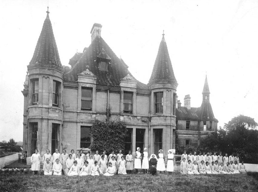
Wales Court (The Manor) 1930. Osbourne Family The Osbornes continued to increase their estates in the area. Sir Thomas Osborne was created Earl of Danby by Charles II and Duke of Leeds by William III. The two manors of Wales were united in 1775 when Francis Godolphin Osborne, later 5th Duke of Leeds, having married Amelia, daughter of the Earl of Holderness in 1773, purchased the Earl’s manor of Wales. On the death of the 7th Duke in 1859, the manor of Wales passed to his nephew, Sackville George Lane Fox, who became 12th Lord Conyers. His descendants lived at Wales Court which remained a home until the 1950s. The house was then converted into a mental hospital which it remained until 1980. I'm not so sure about the 1950's bit, the Manor was definitely a hospital in 1930 as the photo shows
-
Hi Julie Your Grans birth is probably this one: Registered: Dec QTr 1913 Violet HANCOCK District: Ecclesall Bierlow Vol 9c Page 799 Mothers Maiden name FELLOWS Other births registered HANCOCK with mothers maiden name FELLOWS Sep 1911 Ecc Bierlow 9c 750 Charles A HANCOCK Jun 1916 Ecc Bierlow 9c 759 Thomas W HANCOCK Jun 1919 Ecc Bierlow 9c 551 Colin HANCOCK The references quoted are needed to purchase relevant certificates to prove you have the right line. A possible marriage for your Grt Grandparents is: Dec 1893 Ecc Bierlow 9c 383 Herbert HANCOCK & Sarah Harriet FELLOWS This cert will give their fathers names and occupations, their ages and place of abode at time of marriage. Assuming these are the correct people, from 1901 Census Wood Lane Stannington Herbert HANCOCK age 32 Iron Worker born Sheffield Sarah H HANCOCK wife age 29 born Grimesthorpe Sarah H HANCOCK dau age 6 John A HANCOCK son age 4 Leading onto 1911 census Herbert 44 Engine Fitter Sarah Harriet age 36 Grimesthorpe Sarah Harriet age 16 born Pitsmoor John Arthur son age 14 born Heeley Harry son age 9 born stannington Jessica dau age 2 born Walkley Residing at 83 Greaves Street Walkley Viiolets sister Harriet maybe the one listed as Sarah Harriet? they often were called by their middle names Hope this helps Lozz
-
Nice; where's Campo Lane ?
-

Where were the following districts of Sheffield please
RichardB replied to RichardB's topic in Sheffield History Chat
Near Campo Lane, very near ... -
I can't find a Whiteley Wood House in 1891. There's a Whiteley Wood Hall - the owners appear to be away because there is only a family called SLACK, with the Head as a gardener and eldest son as a groom/gardener. This may not be the right house though as the 1920 Directory says it is in Common Lane. Hugh
-
I think it was the apparent hill that threw me. I assume the photo looks towards Middlewood Rd if the old Post office is on the right? By the way, Hillsborough Place crosses the end of Hillsborough Rd and joins Holme Lane. Thanks for the update. :rolleyes:
-
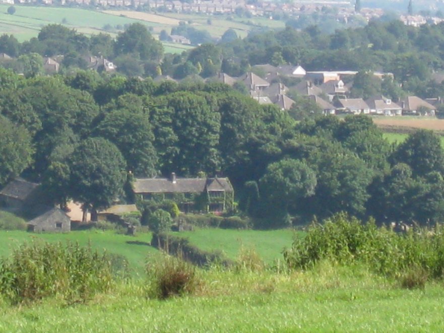
Hi Steve, Green House Farm is on Andwell Lane in the Mayfield Valley. It's still there and a thriving farm and dog kennels. I have a contact number of the current owners if you want to get in touch. Mike
-
I've walked past this place today what a shame, I use to go to the social club when it belonged to Marshalls before it was sold to Hepworths. Thomas Marshall was the last to live in it as a home. Thomas Marshall collided with a wagon down the nearby lane and died in the late sixties. It stood empty for awhile until they made it into offices for Marshalls in the early 70s.
-
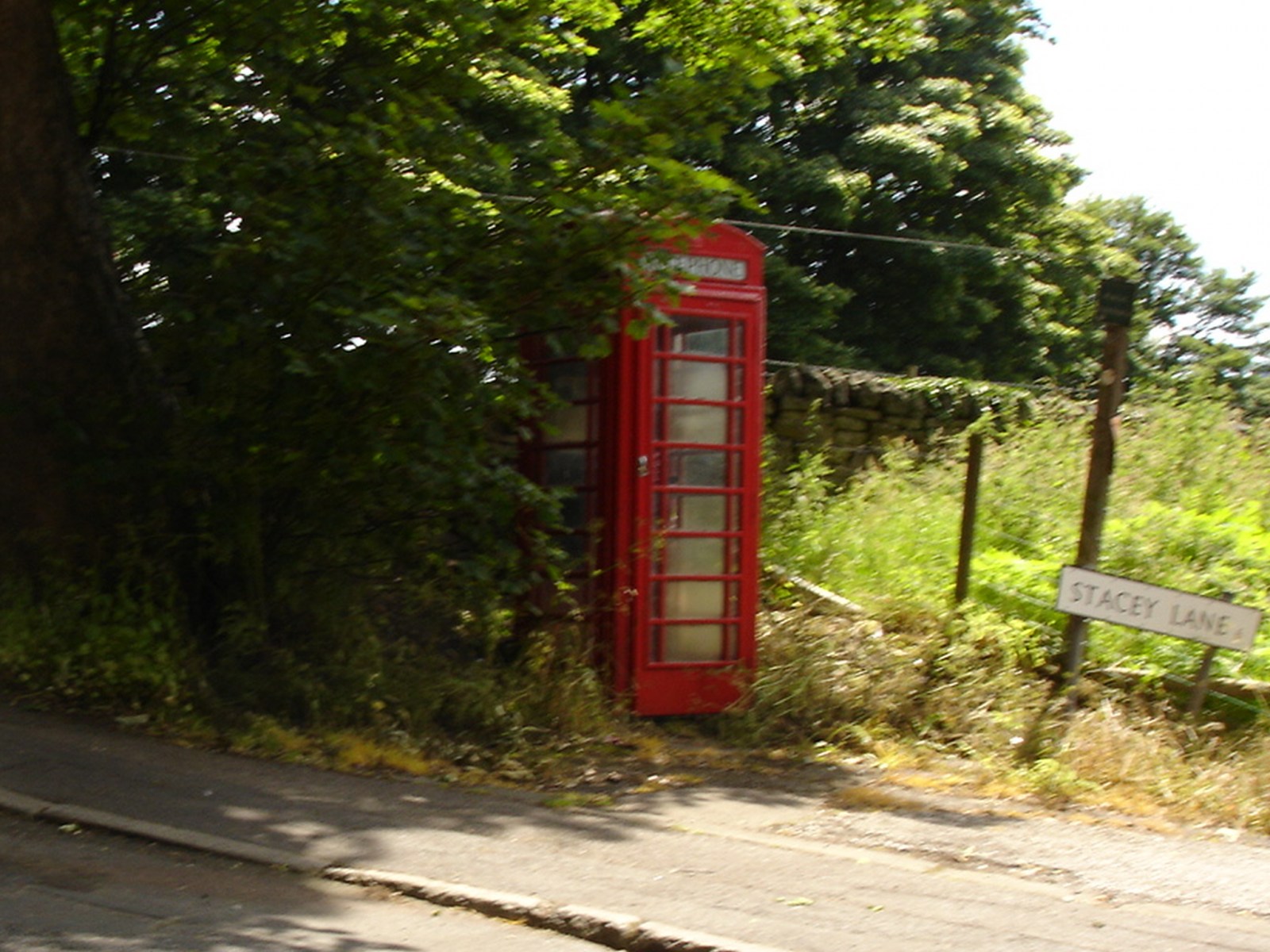
Loxley road / Stacey lane.
-
Crimicar lane is difficult. All I have found is a short reference by Mary Walton to the effect that it was built as a sanatorium by the 'Corporation' in 1902 for the treatment of pulmonary disease, principally tuberculosis. Lodge Moor was built as a Fever Isolation Hospital. Started in 1887 following a widespread outbreak of smallpox, twelve wooden huts were hastily erected in the wilds of Lodge Moor and surrounded by a fence; it was named as the Borough Small Pox Hospital. A Matron was appoinred with a staff of eighteen nurses, sixteen servants and two porters who lived on the premises. From 1892 the wooden huts were gradually replaced by stone buildings which continued until 1935. The elimination of smallpox did not remove the need for an isolation hospital as there were still diphtheria, scarlet fever and measles etc. to deal with. Further wards were added until 1940 and eventually with the decline of infectious diseases Lodge Moor became more of a general hospital. There was another 'fever' hospital in Sheffield on Winter street. This was built in 1881 and known as the Borough Hospital for Infectious Diseases. It was extended in 1892 and in 1898 eight cottages were added to enable 'contacts' of the inmates to be accommodated in isolation from the general population. In 1912 the use of the hospital was changed to a TB sanatorium. it was used as a military hospital during WWI and was later renamed as St. George's Hospital. [i have no recollection of this place...does anyone else have some input ??] Need some info on Common Side Sanatorium.
-
Steve, I think what you need to know is what date range is covered by the maps, ie earliest and latest dates. For instance on the 1850 OS map on Pond street only three pubs are shown between Pond Hill and Harmer lane - the Royal Oak, the Grapes and the Barrel. These are about where they're shown on your pdf map but the OS map has no property numbers. On Pond hill I only have the Black Swan and the Horse and Jockey. I don't believe the Queen's Head was opened as a pub until 1853/4. I suspect the pubs on your pdf maps have been put there on the strength of their appearance in street directories, perhaps over a span of fifty years or more. Pubs come and go - time waits for no man he he
-
By gum ! That's a long list laddie I only suggested this because of the apparent confusion between Lodge Moor and Crimicar Lane but anyway here's a few details for starters. Nether Edge Hospital began life as the Ecclesall Union Workhouse in 1844. After 1929 it was renamed Nether Edge Hospital and had general wards, a maternerty hospital and TB sanitaria. Several buildings were hit by bombs during the blitz of 1940. The hospital site was redevloped for housing in the 1990s. Hollow Meadows Hospital was originally a 'Workhouse Farm' administered by the Sheffield Union Board of Guardians for the employment of paupers. In 1879 it became an 'industrial' or reform School for children who were persistent truants. Further info neede on when the site became a hospital. Northern General Hospital was developed from the Sheffield Union Fir Vale Workhouse opened in 1881. From 1930 the site became known as the City General Hospital and was again renamed in 1967 to the Northern General Hospital. Think we need a separate post for each hospital at this stage. and | suspect there is already a lot of info already on the forum about several of the major hospitals which needs linking in or cut'n'paste jobs.
-
Here's an initial list from the index of Edward Vickers 'Popular History of Sheffield' Charles Clifford Dental Children's City General Crimicar Lane Dispensary (1st) Fulwood Annexe General Infimary Hallamshire Hollis Jessop King Edward V11 Lodge Moor Middlewood Nether Edge Royal Ryegate Annexe Saint Joseph's Saint Leonard's Sheffield Public Shrewsbury Thornbury Annexe Weston Park wharcliffe Whitely Wood Clinic Winter Street Women's (1st)
-
Halifax road/Salt Box Lane. Langsett road Oughtibridge.
-
A couple I've notice recently where the "building" is till there - by the Jet Petrol Station on Owler Lane Grimesthorpe/Page Hall and in the wall of Abbeyfield Park across from the old Pitsmoor Toll House lol
-
The NRA shows records - 1916-92: staff minutes, committee minutes, admissions registers, operation registers, case files, visitors book, are kept at Sheffield Archives. http://www.nationalarchives.gov.uk/nra/sea...w.asp?ID=O62742 And some good photos here... http://www.geograph.org.uk/search.php?i=6845183 I notice that if 'Fever Hospital' is used as a search term on Picture Sheffield it brings up photos of both Crimicar lane and Lodge Moor hospitals...but the King Edward VII Orthopaedic Hospital is something and somewhere completely different. Much confusion here !!! We need a sticky topic for Sheffield Hospitals.
-
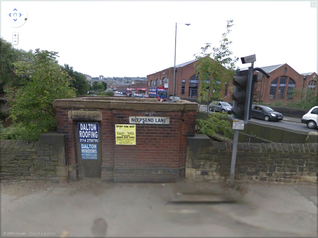
Closed down gents toilet on the corner of Rutland Rd/Neepsend lane. Google SV.