Search the Community
Showing results for 'coal pit lane'.
-
Hi All Have been doing some research myself since my last post. Henry Biggin had a mortgage on a property (170-174 Bramall Lane) in 1881 from a man called Henry Holdsworth. Henry then leased that land etc to Charles William Fletcher in 1899. I have since found that Charles owned or managed Sterling Works (and Butcher Works) but Sterling works appears to be in Arundel Street, not Bramall Lane. Could it be that Henry ran/owned these prior to Charles. Apparently he left a factory to each of his children at his death - so they must be somewhere. There is also the Wostenholme and Biggin connection - possibly in Fitzwilliam Street at the time of the terrible flood as Henry claimed damages. Any information would be very gratefully received as I am hoping to visit Sheffield very shortly, and would like to "see" what is left of anything.
-
Thanks, - nice to have a mystery solved. The Whitehouse was still on the corner of Cherry street, in the photo you can see the frontage of the Olympia building beyond the cottages and beyond that the fence/hoardings that bordered the Sheaf House Athletics Ground. The Whitehouse photo looks to have been taken from an upstairs room of the pub that stood on the corner of Hill street and Bramall lane, and the Olympia photo taken from the bottom of Alderson place. That area was a stomping ground for me as a youngster and the ground floor windows of that Olympia building seem very familiar. We used to sneak in to Lavers via the side gate on Cherry street to watch the big saw working, —it was a 10 or 12 foot diameter circular saw (as often featured in the old silent films) and the huge tree trunks were fed onto it with an overhead crane. That would be around 1947/48...we usually got chased out by one of the workers.
-
The old smells of Sheffield
ukelele lady replied to Sheffield History's topic in Sheffield History Chat
Sorry that should have been Neepsend Lane. -
The tall building with the fancy roof-line that can be seen in the background of the Whitehouses picture was probably a skating rink. In the 1910 directory it is listed as the property of Sheffield and Olympia Rinks Ltd., Shoreham street and Bramall lane. By 1917 the site was listed as Lockwood & Co., Engineers. It looks as though the Whiteshouses site was bought by the Anchor Brewery on Cherrry street and the main house let to the horse-keeper for the brewery's horses which were stabled on the site.
-
Midland Street, near Bramall Lane Ground is unadopted according to the Star. http://www.thestar.co.uk/action/Parking-ma...fine.4602653.jp
-
Sheffield and Rotherham Independent, 6 Apr 1850 TOWN-HALL [Magistrates' Court] The following publicans and beerhouse keepers were fined for offences against their licenses:- Wm. Charlton, All Nations, Water lane, 5s., and 8s. costs; John Staniland, Woodman, Sheffield moor, 40s., and 8s. costs; John Challinger, Punch bowl, Silver-street head, 10s., and 8s. costs; Wm. Mallinson, Half-moon, Silver-street head, £5, and 8s. costs; and Hy. Smith, Ten bells, Westbar, 20s., and 8s.costs. Hugh
-
Steve Looks like part of the Health and Safety Executive complex off Broad Lane. HSE
-

Other Maps/Plans/Layoutshttps://www.sheffieldhistory.co.uk/forums/topic/4458-other-mapsplanslayouts/
Guest replied to RichardB's topic in Sheffield Maps
This is a photo of a picture that my mum has. (sorry for the poor quality, it's taken through glass) It's dated 1745, and the following is written below the picture: "Sheffield or Sheafield stands in the southern part of the West Riding of Yorkshire where the two Rivers Dun and Sheaf meet, to which last it owes it's name. This town was anciently famous for making the iron heads of arrows, and is celebated by Chaucer 300 years ago for the blades of knives worked there; by degrees it hath much improved in all manner of cutlers ware. Its situation is delightful and somewhat uncommon, it being seated on a round hill in the midst of a valley which is surrounded by many higher hills: This supplies it with many valuable falls of water necessary for carrying on the manufacture of the place. This advantage of streams to turn their mills, together with great plenty of coal in its neighbourhood render it perhaps the fittest place in the kingdom for the business which is here carried on. It had a very strong old castle which belong'd to the Lovetofts, the Lords Furnival and the Talbots, Earls of Shrewsbury. In which Mary Queen of Scots remained a prisoner for 16 or 17 years under the custody of George Earl of Shrewsbury. This castle was built in the reign of King Henry III and after the death of King Charles I, was demolished. Here is a market every Tuesday and Thursday. Fairs, one on Tuesday after Trinity sunday, and another on the 28 November. The Manor of Sheffield, which extends in length 18 miles and in breadth upwards of 8 miles, did formerly belong to the Earls of Shrewsbury; but now to his Grace the Duke of Norfolk." Jeremy -
This is a photo of a picture that my mum has. (sorry for the poor quality, it's taken through glass) The following is written below the picture: "Sheffield or Sheafield stands in the southern part of the West Riding of Yorkshire where the two Rivers Dun and Sheaf meet, to which last it owes it's name. This town was anciently famous for making the iron heads of arrows, and is celebated by Chaucer 300 years ago for the blades of knives worked there; by degrees it hath much improved in all manner of cutlers ware. Its situation is delightful and somewhat uncommon, it being seated on a round hill in the midst of a valley which is surrounded by many higher hills: This supplies it with many valuable falls of water necessary for carrying on the manufacture of the place. This advantage of streams to turn their mills, together with great plenty of coal in its neighbourhood render it perhaps the fittest place in the kingdom for the business which is here carried on. It had a very strong old castle which belong'd to the Lovetofts, the Lords Furnival and the Talbots, Earls of Shrewsbury. In which Mary Queen of Scots remained a prisoner for 16 or 17 years under the custody of George Earl of Shrewsbury. This castle was built in the reign of King Henry III and after the death of King Charles I, was demolished. Here is a market every Tuesday and Thursday. Fairs, one on Tuesday after Trinity sunday, and another on the 28 November. The Manor of Sheffield, which extends in length 18 miles and in breadth upwards of 8 miles, did formerly belong to the Earls of Shrewsbury; but now to his Grace the Duke of Norfolk." Jeremy

-
Other Maps/Plans/Layoutshttps://www.sheffieldhistory.co.uk/forums/topic/4458-other-mapsplanslayouts/
Guest replied to RichardB's topic in Sheffield Maps
It is quite feasible that the map you refer to predates the 1905 map, for the following reason:- There were two church buildings belonging to the Methodist church at South view road/ Sharrow Lane junction. The first incarnation of the church, a very simple building, which was closest to south view road, was built in the 1880s, (1889 to be precise) and the congregation rapidly outgrew the building, by around 1900. (you can still see the dedication stones, and the carved decorative lintel which reads "Methodist New Connexion 1889") In 1906, the second, larger church building was opened, immediately adjacent to the first, just above it, on the frontage to Sharrow Lane. The original church building was relegated to the status of "Church Hall" (look for photographs on picturesheffield of "Sharrow Methodist church" for the opening ceremony in 1906.) My ex-husband and I were caretakers at the church some fifteen years ago. I have in my possession a copy of the church's history, written by the late Ken Styring, who was the church secretary. It tells of the joining of the church with defunct Methodist churches in south street and franklin street, and the congregation of the bombed-out John Street Methodist church being enfolded within the membership. By the early 1990s the congregation had dwindled to very few,and sadly, the church became unsustainable, and by 2005 had been forced to close down, just shy of the "new" building's centenary. -
Other Maps/Plans/Layoutshttps://www.sheffieldhistory.co.uk/forums/topic/4458-other-mapsplanslayouts/
Guest replied to RichardB's topic in Sheffield Maps
I've been comparing it with the 1905 OS map and there are some indicators to it's date although they seem contradictory. In the Sharrow area for example this map shows the church on the corner of Sharrow lane and South View road which I believe was built around 1905, yet nearby roads such as South View crescent, Rampton road and Ainsty road are devoid of houses which contradicts the 1905 OS map. Perhaps all we can claim for it is that it dates from about 1905/06. Perhaps the tram routes can give a better indication ? My tramways book is on loan at present so I can't check. -
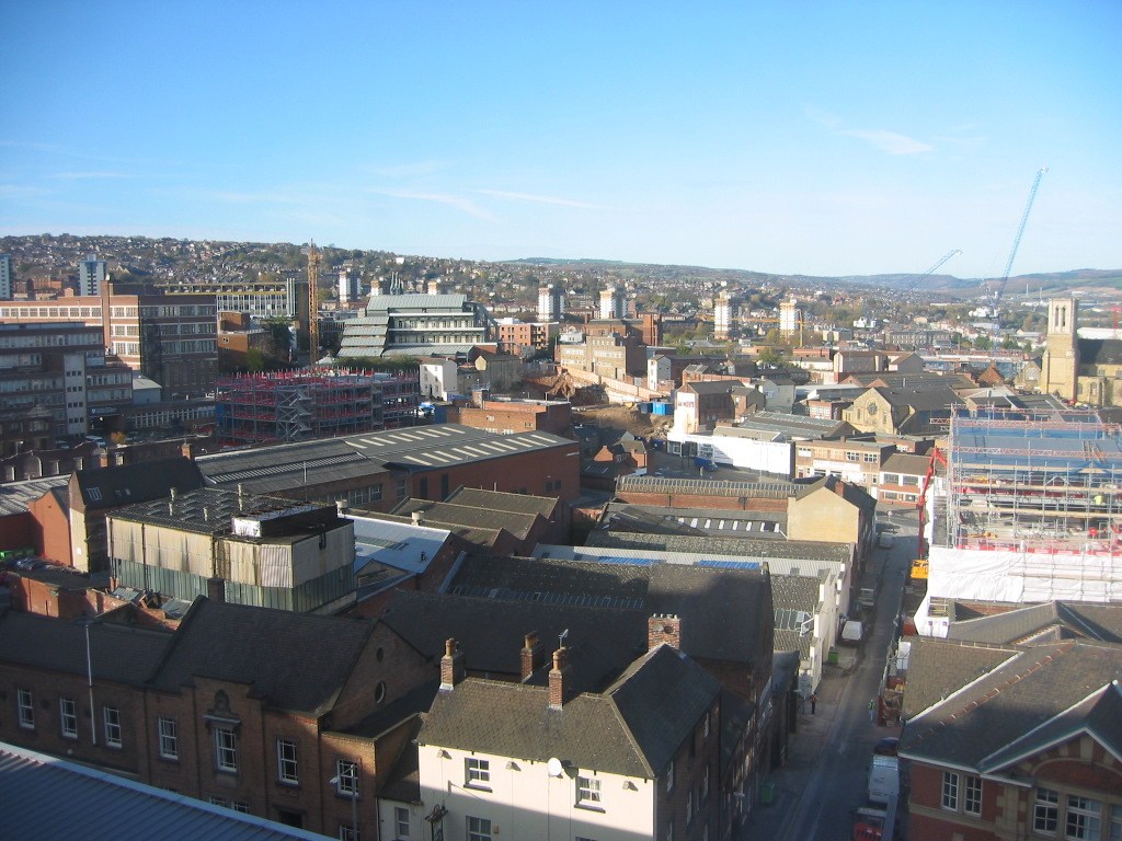
Inspired by an aerial photograph of the Cathedral. Keeping it central, Wicker, Castle Foulds, Snig Hill, Westbar green, Lambert Street/Grindlegate, Glossop Road, Barker Pool, Coalpit Lane - you get the rough idea - a Greatest Hits if you like !
-
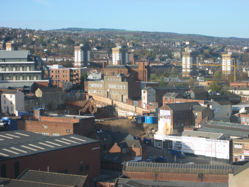
Took this picture from the stairwell at the back of the office block I work in, looking North (ish). Shows a few building sites which are now complete as appartments and offices. The site on Broad lane below the HSE building is now at foundation stage with a tower crane installed.

-
Where have you worked that's no longer there ?
Guest replied to Sheffield History's topic in Sheffield History Chat
cockaynes high st hatfields steel works j w sivil [builders] Frank Astlings [builders]literally thousands of houses now demolished 2 year spell self employed[at 22 years old] Gleesons[builders] erected store sheds at the re start of the manor estate housing [held over for essential works ]then on some of the houses. G Bradburys[builders] Stones brewery Sheffield Smelting co Royds mill lane Then a 30 year stint self employed as a joiner and builder, thousands more Sheffield premises and houses all gone . 1971[Estate surveyers dept 1972 [inspectors dept Sheffield Housing] Shiregreen and Wincobank estates [1985brings earley retirement at 60yrs old SKEETS -
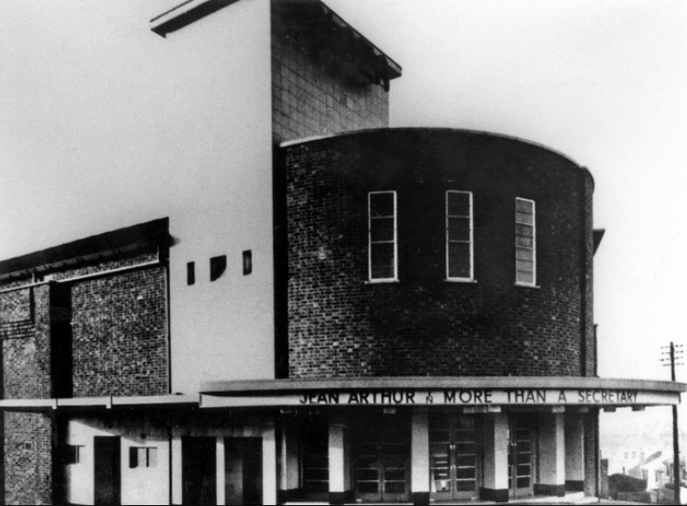
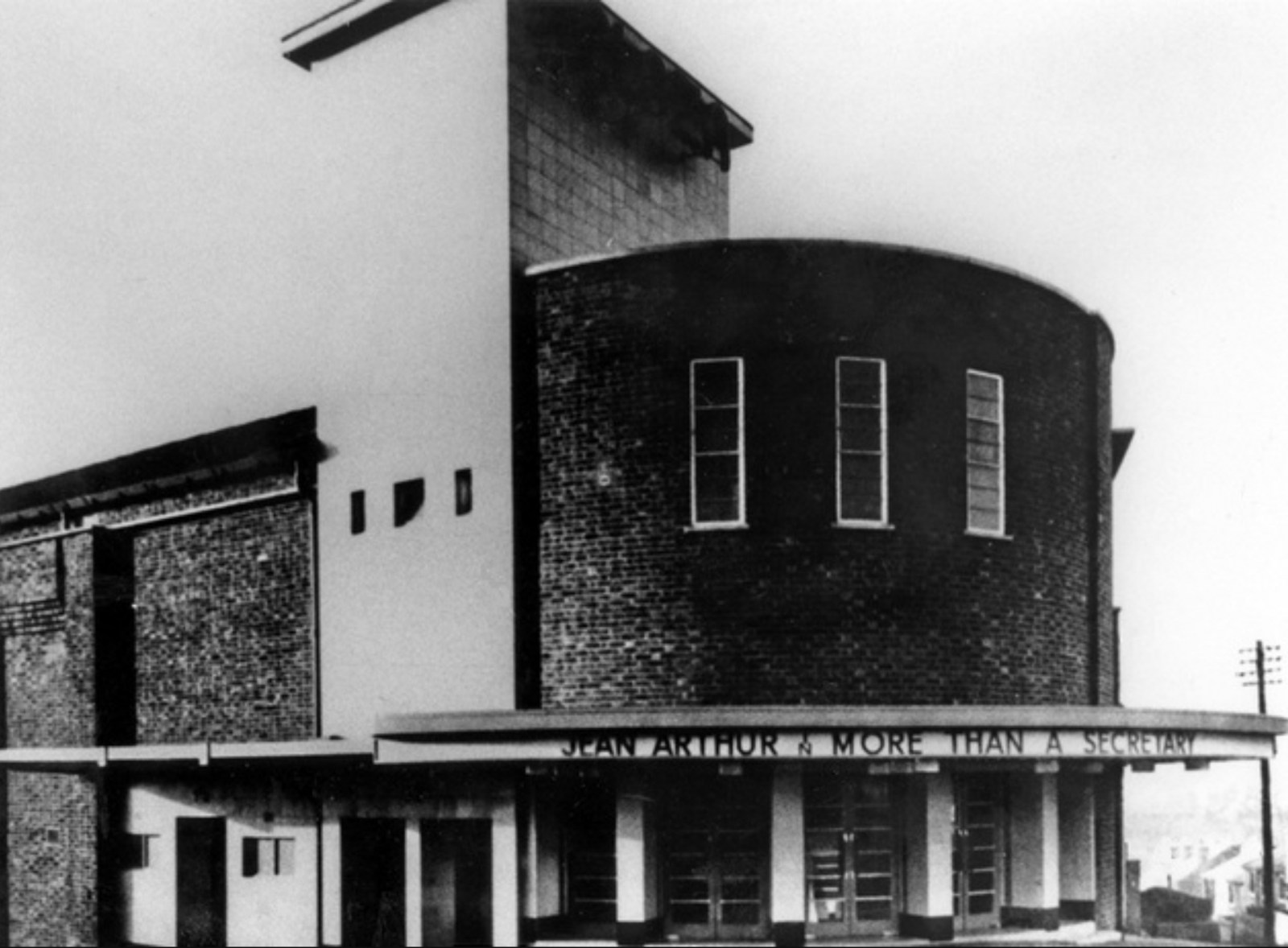
The Plaza Cinema, Richmond Rd. Handsworth, Sheffield Located at the junction of Richmond Road and Bramley Lane, the Plaza was opened on the 27th of December, 1937. A modern building, it was built in rustic brick with the tower faced with white faience. The upper part of the tower housed the air conditioning system. Seating in total was for 1,100 patrons with adequate waiting room provided in the entrance hall and foyer. The entrance was covered by a sweeping canopy with stairs to either side of the balcony. The auditorium decor was of decorative fibrous plaster with the walls in orange fading to a light buff towards ceiling level. Concealed lighting was hidden in ceiling troughs. Projection equipment consisted of a Western Electric mirrophonic sound system, Kaylee No. 11 projectors and Regal Arc Lamps. The Plaza had only two managers in it's cinema lifetime, George Turner being the first, who was replaced by Colin Arnold in December of 1957. The hall had closed for a brief period in July of 1947 for redecoration and refurbishment. The Plaza was opened for Sunday screenings from April 1953 with a children's Saturday matinee following just under twelve months later. CinemaScope presentations with stereophonic sound were introduced in March of 1955 with "Three Coins in the Fountain". The cinema closed for redecoration in September of 1962, and a year later saw musical groups and variety acts booked for a series of one night stands. These performances did not feature any film screenings. The Plaza was taken over by Ken Kerner Entertainments Ltd in 1963, and closed as a cinema in September of that year. Info: Sheffield Cinemas
-
If that is the Ebeneezer chapel in the background there is something wrong somewhere. It was on the opposite side of Brammal lane to the Whitehouses :confused: And I believe the family name was originally Bramhall but Sheffielders never had much truck with aitches he he
-
The Roll of Honour (printed in the Star's book Sheffield Blitz says: LAWRENCE George Herbert, age 52. Husband of Elsie Lawrence, of Belmont, Hathersage, Derbyshire. December 13, 1940, at Laurel Works, Nursery Street. This is a picture of the Laurel Works. Picture Sheffield also has the name 'Lawrence Geo H Ltd' as a keyword for a picture of the Green Lane Works so he may also have worked there at some point. This is likely to be the entry for George and Elsie in the marriage index: GRO Marriages DEC Qtr 1916 BOLTON Elsie (spouse: Lawrence) Sheffield 9c 1193 LAWRENCE George H (spouse: Bolton) Sheffield 9c 1193 Hugh
-
A couple of other suggestions for Campo Lane... Joseph Hunter in 'Hallamshire' gave this folk etymology: It is a prevalent opinion at Sheffield, that the area of the present parish church-yard was anciently a camp of the Romans. It is well-known that such situations were sometimes chosen for the erection of Christian temples; and the name of a street which passes under the walls of the cemetery on the north side, Campo-lane, may seem to give some countenance to the opinion. I have also heard that urns containing ashes as of some human body that had been burnt, were found several years ago on digging in the neighbourhood of Bank-street. Sidney O Addy in his 'Glossary' gave a couple of suggestions: In Gosling's map of Sheffield, 1736, it is called 'Camper Lane.' The same map shows the position of the old 'Latin School,' or Grammar School, and the 'Writing School.' These schools were at a very short distance from Campo Lane, and it seems probable that here the game of football was played. The Grammar School was founded in 1603. The Prompt. Parv. has Campar or pleyar at footballe, pedipilusor.' (See the note in Way's edition.) In Brinsley's Grammar Schoole, cited by Mr. Furnivall in Early English Meals and Manners, p. Ixii, I find this passage:— 'By this meanes also the schollars may be kept euer in their places, and hard to their labours without that running out to the Campo (as they tearme it) at school times, and the manifolde disorders thereof; as watching and striuing for the clubbe, and loytering then in the fields.' (For the meaning of 'clubbe,' see pp. 299 and 300 of Brinsley.) Hunter says:—'The Campa field' occurs several times in the returns of their Sheffield estates by the Dukes of Norfolk, compelling Roman Catholics to register their estates with the Clerk of the Peace. This proves that there was once a field in Sheffield appropriated to this sport, and what more probable than that it was the open space now called Paradise Square? Campo lane, so called, as leading to it—in full, the Camper field lane.'—Hunter's MS. Bateman opened a barrow at the summit of a rocky hill, near Ecton mine, called by the natives the Comp.—Ten Years' Diggings, p. 34. Cf. Compton, near Ashbourne. Bateman opened a large barrow at Cawthorn Camps, Yorkshire.—Ibid., p. 206. See CAMPFIELD. As Campo Lane runs along the ridge of a steep hill, the most probable derivation is O. Icel. kambr, a ridge. Jeremy
-
Joseph YEARDLEY Shopkeeper 43 Green Lane Pigot's 1841 Joseph YEARDLEY Householder 5 Leamington Street White's 1919 Joseph YEARDLEY Furniture Broker Infirmary Road White's 1852 Joseph YEARDLEY vict. Sportsman Pitsmoor White's 1833 Joseph YEARDLEY Beer retailer Potter Hill, Chapeltown Kelly's 1893 Joseph YEARDLEY Victualler Sportsman's Inn, Pitsmoor White's 1852 Thomas YEARDLEY Farmer Potter Hill, Chapeltown Kelly's 1893
-
The RED DEER on Pit st was a popular pub in those days. Did you mean the Foresters accross from the Prince. Skeets
-
Aren't these maps just great. Pointers for the age of these. No Hurlfield Secondary Schools the boys opened in 1955/6. Jaunty Lane at Intake the council estate is not built c 1954 No sign of the Hallamshire Out Patients Houspital mid to late 50's So pre 1954 if the map was upto date jiginc
-
Under the heading Making Files in Sheffield ,posted today by Dunsbyowl, read about The FitzalanWorks.It states that there was a wharf on the canal where shipping was done with Hull. I have a map of Sheffield dated 1849 showing that the Fitzalan Works were east of Washford Bridge next to the Blast Lane towpath. http://www.sheffieldhistory.co.uk/forums/i...amp;#entry25093
-
I'm feeling a need to generate a listing of all Pork butchers (obviously Victorian/Edwardian); Funk's of Hillsborough - is it still there ? Bottom of Dykes Hall Road, but formerly of Holme Lane. Oh God, RichardB's going off on one again; Tsavo HIDE !!!!!
-
The 1905 map shows a dock and a coal wharf on the canal. It's somewhere near where Tinsley Park Road meets Shepcote lane. Maybe under or next to Ranskill Court on current maps.
-
Found it now, "Bailey Field, then a newly-made street, running through the open land between Trippet Lane and Broad Lane" according to Leader's Sheffield In The Eighteenth Century. Richard, - can I ask what you're quoting from ?