Search the Community
Showing results for 'coal pit lane'.
-
I thought Pea Croft was a forerunner of Solly Street; never mind, there could well have been more than one. Samuel HANCOCK Penknife manufacturer and grocer & flour dealer 36 West Street Baine's 1822 Samuel HANCOCK Pen and Pocket Knife Manufacturers Bailey Street Pigot's 1828-9 Samuel HANCOCK Shopkeepers & Dealers in Groceries & Sundries 40 Bailey Street Pigot's 1828-9 Samuel HANCOCK pen and pocket knife manufacturer & shopkeeper 39 Bailey Street White's 1833 Samuel HANCOCK Shopkeeper Pea Croft Pigot's 1841 Samuel HANCOCK razor, table, butcher, pen, pocket & sportsman's knife manufacturer (& son) 45 Peacroft; h, Northumberland Road White's 1852 Samuel HANCOCK Cutlery manufacturer (S Hancock & Sons) 103 Button Lane & Mazeppa Works, Bishop Street Kelly's 1893 Samuel HANCOCK (& Son) manufacturers of pen & pocket knives Moorfields Works, Snow Lane White's 1919 Samuel HANCOCK (& Son) pen & pocket knife manucturers Moorfields Works, Snow Lane Kelly's 1925 I can see where Bailey Street and Pea Croft, Netherthorpe come together - and there's a 1893 mention of Button Lane. http://www.sheffieldrecordsonline.org.uk/
-
Does anybody know about this place called the Pea Croft or have any information, please? I believe it was a street near Button Lane, now underneath the roundabout near John Lewis and formerly outside the old Grosvenor Hotel. I think the street was demolished in the early 1950s. I am interested in it because my family owned a cutlery business there called Samuel Hancock and Son in the 18/19 century.
-
I don't know whether there's any connection, but on the 1637 Harrison survey there are several fields near Watt Lane at Crosspool called Ramscar Fields. I've not been able to find any explanation for the name, but I wonder whether the connection is to the family gramps mentions?
-
There is/was speculation that this was the HQ of the Cutler's Company before the first Cutler's Hall was built in Church lane.
-
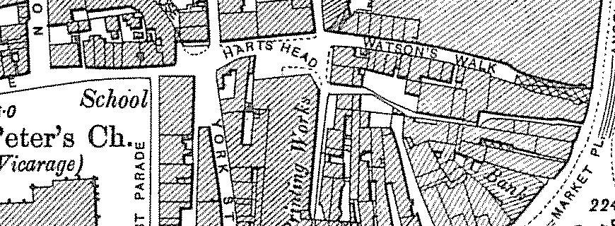
This a plan of the old Watson's Walk... The old Dove and Rainbow stood at the end of it facing up Campo lane The narrow jennel below Watson's Walk may be the old Hartshead Passage.
-

Tram - Origin of the Name?
Stuart0742 replied to dunsbyowl1867's topic in Sheffield Buses, Trams and Trains
The font of all knowledge "Wikepedia" states The terms “tram†and “tramway†were originally Scots and Northern English words for the type of truck used in coal mines and the tracks on which they ran probably derived from the North Sea Germanic word “trame†of unknown origin meaning the “beam or shaft of a barrow or sledgeâ€, also “a barrow†or container body. Just another explanation See also Ron's World of Trams -
Interesting, I can't quite make out the details on that old HMV Red label on the record in the Phillip Cann sleve, but, judging by the size of the label to the diamater of the disc, and the quarter inch spindle hole lacking a Juke box knock out I guess this is a 78rpm disc. If so it probably predates 1960 and gives some idea how long it is since Phillip Cann traded from Dixon Lane. Some record companies used Coloured labels to indicate the style of music, eg if it was "Parlophone red label" it was Jazz, although most people would be more familiar with pop music, particularly the Beatles, on "Parlophone black label" I don't know what colours HMV used, but even so this is still a nice image of their famous "his Masters Voice" dog and Vitriola phonograph logo.
-
First school was St Vincents, think it was the bottom of Edwards Street. I don't live in Sheffield any more, haven't done for years, but recently went to see what was left of St Vincents.....a very sad sight indeed. derelict school building and church...now a car park for all the 'city workers'. Left St Vincents in 68 to go to Lydgate Lane, which looks exactly as it used to. Went to Tapton Comp, 73-78. Tapton has been totally rebuilt since my day.
-
Gramps' post 'Oct 23 2008, 02:42 PM' I know of three, one in the Bellhouse road/Windmill lane area, another on Western Bank and one in Attercliffe. Hi Gramps, returning to the original subject of this thread! Have you seen this print before? If you look closely you can see the windmill at Shiregreen of the horizon to the left. lol
-
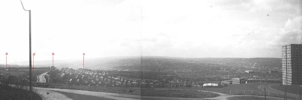
DaveH, You're right , that is Myrtle Road and on the far left at the top of Spur Lane(d) (just this side of the Sports Ground) is Ash Farm(a). On the brow of the hill where Myrtle goes out of sight stands the Ball Inn PH(, Heeley Bank School© can just be seen. My house is also on the view, but I ain't marking it as I don't want you buggers on here coming over and robbing me!
-
Looking at SteveHB's map again reminded me of an old story. Before the Norfolk Park Estate was built and it was farmland. Arbourthorne Road came to an abrupt end where it now meets Park Grange Road (at the current site of the Fellbrigg / Beacon), but it did extend beyond its junction with Fellbrigg Road by a few yards giving the impression that it was going to go somewhere. At the other side of the estate was St. Aidens road which was also a dead end, it ran in from City Road to the edge of the quarry outside Norfolk Park and just stopped, again it went beyond Norfolk Park Avenue, the last road to join it, giving the impression it was going to go on somewhere. The clue is in the original name of St. Aidens Road, - at one time it was called "Arbourthorne Road". was there plans to join the two ends up into an extended Arbourthorne Road which would run directly from City Road to the top of Hurlfield Road? The old story I heard was that as the housing at the St. Aidens end was private and therefore "posh" and at the other end was "council" and therefore a bit rough, the residents on the St. aidens bit objected to it being joined and had the name of their bit altered to "St. Aidens Road" to disown the lower quality Arbourthorne. What a set of snobs! A more likely and realistic reason for not connecting the two halves would have been the route through the Jervis Lum, those 2 small ponds are right in the way and the land which slopes down beyond is that wet boggy area, - not such a good idea then. The prop[osed route would have had to go through the quarry along the Park wall, past the park entrance, follow the route of the current Guildford Avenue a bit but then swing up that steep wet bank above Norfolk Park stream to meet the other Arbourthorne Road by going through those 2 small ponds. When the estate was built, Arbourthorne Road just joined Park Grange Road. I can remember piles of building material being left at its dead end blocking it off for a while, some of it would be used to build the new estate but I bet some of it was used to fill those 2 ponds in. At the other end, St. Aidens Road took a sharp bend up the hill towards Spring Lane and Park Grange Road, to avoid both the quarry and that other piece of unbuilt land the "smouldering tip", an area of land also never built on until recently and for a time used as a football field. This land got its local name because it seemed to consist of mining slag which was always burning.
-
Can anyone remember Phillip Cann (the music man) on Chapel Walk, and before that on Dixon Lane? Yes I can remember Phillip Cann (the music man) went there for a job interview just before I left school. Did not get the job and went to Wigfalls instead.
-
They also seem to have taken some of the street names from them. Truswell (Avenue) and Holme (Lane) stand out among others at first glance. Will study that a little closer and see if I can do a match overlay of the streets. Thanks for the head up Bayleaf. Laurence
-
On the subject of Coalmining, the National Coal Mining Museum for England is based at a former NCB Pit and is on the A624 Huddersfield to Wakefield Rd. Well worth a visit if you have an interest in mining or your relatives were emoployed or just for a day out. Here is the big bonus IT'S FREE. National Coalmining Museum I have no connection with the museum, just reccommendation. I think there is a museum in the North East for those that choose to live up there.
-
Residents of a Court, School Lane off Duke Street, Park (1920's) Picture Sheffield
-
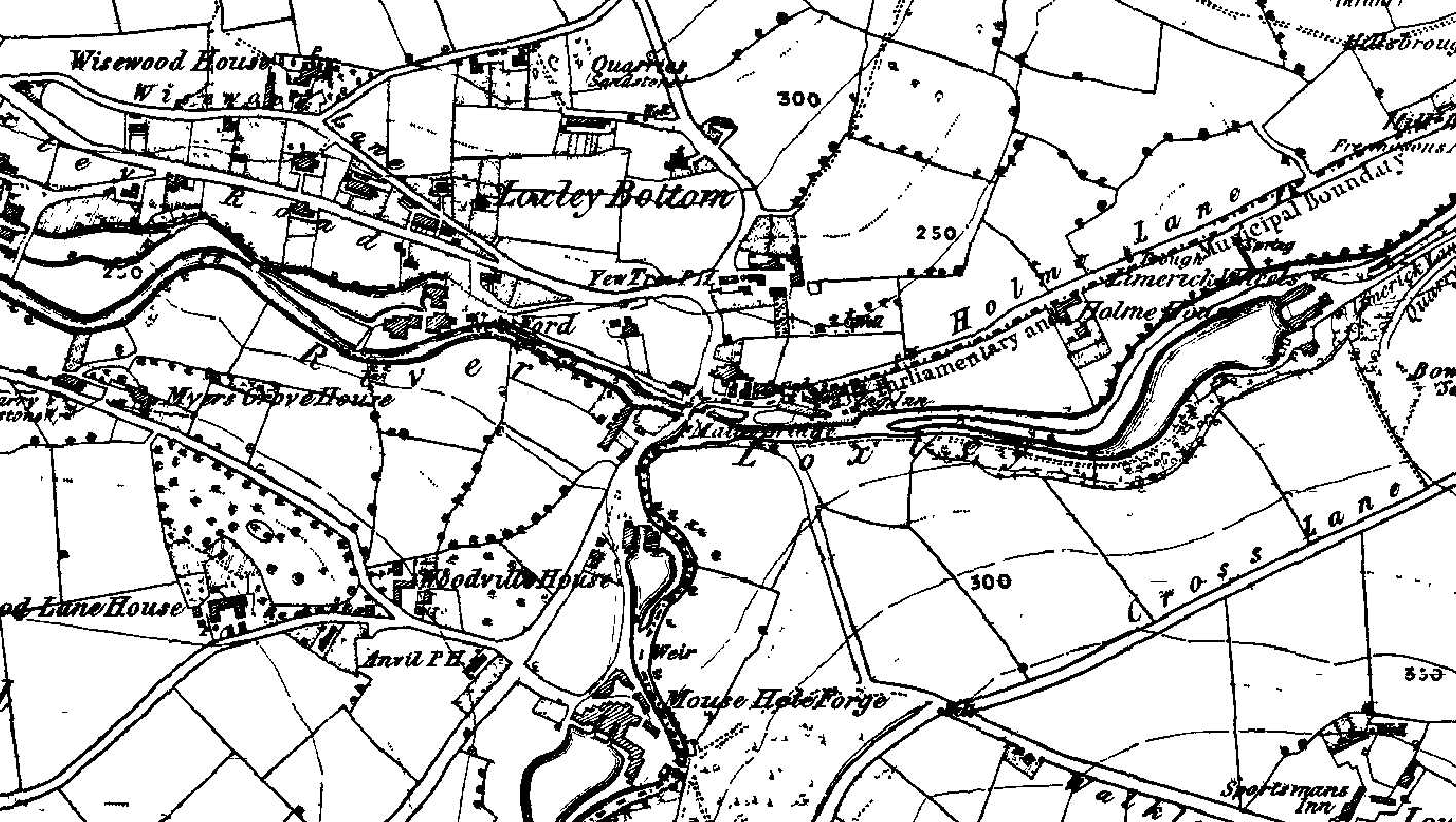
Malin Bridge was a busy little place in the 1850s - lots of dams and waterwheels, some substantial houses, a farm or two and three pubs; the Anvil, the Yew Tree and the Stag Inn. The earliest mention I've found of Malin Bridge as a place is the will of a William Fenton of 'Mallinbrige' dated 5th. May 1578, and another in March 1590-1 for the will of a Nicholas Hobson. Malin was the peculiar Christian name used by the Stacy family for several generations and I read somewhere that there may be a connection between this family and the construction of the first stone bridge here. The waterwheel of the old corn mill on the corner of Stannington road and Holme lane is once again being restored to working order as a condition placed on the developers of the site.

-
I have a feeling its source may be on the old Hurlfield school fields just at the side of where they have built the new Springs academy. This area of field always seems to be muddy, even in dry weather and when it does occasionally dry out the soil soon has that characteristic cracked "crazy paving" appearance that dried out waterlogged land has. Even the new school has not been built on this land, - is it too soft and wet? If this is the source perhaps "Springs Academy" (Myrtle Springs) is an appropriate name. Myrtle Springs itself is further west still and plain talker has commented in a previous post of the wet land closer to and even on the other side of Arbourthorne Road. I think the source may be on Hurlfield fields because this is the highest point, from here the land slopes away in every direction. On the other side of Hurlfield Road is the old water works building on what was Hagg Lane. The Hagg Lane tanks were placed here at this high point to provide water at the greatest pressure, a sort of natural water tower.
-
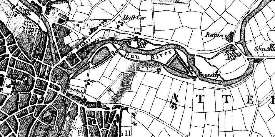
The web site quoted here seems to have been taken down, but a little research suggests that the claim that Lady's bridge was merely a foot bridge is unfounded. The first assertion I've met with that the only approach to the 1485 Lady's Bridge was via steps and that wheeled traffic was forced to use the Sheaf Bridge, is in R.E. Leader's Sheffield in the Eighteenth Century (1905). This claim was repeated by A.L. Armstrong in his account of the excavations of Sheffild Castle and by Charles Drury in his article on Sheffield Castle in the book A Sheaf of Essays by a Sheffield Antiquary (1929). However in his lecture Sheffield's Old Roads, R.E. Leader takes the opposite view and tells us that in 1607 the passage from Rotherham to Sheffield was via Wasford bridge and that the road went "by Royd's Mill to the somewhat higher level of Carlisle Street, past Hall Car and down Spital Hill to the Wicker." He also quotes the account of the chaplain to the Earl of Oxford who travelled from Rotherham to Sheffield in 1725 "Then, after crossing the Don twice more, the first, I think, over Washford, and the next over Lady's Bridge, we get into the town of Sheffield". From an examination of the bridge made in 1909 it was established the the original, dating from 1485 was 14 feet 8 inches wide; qute wide enough to allow two waggons of the period to comfortably pass each other. Why build a bridge of such width if it was intended only for foot traffic ? The steps alluded to appear to have been provided to allow pedestrians access to the bridge from the lane known as 'Underthe-Water' which was eventually replaced by the modern Bridge street. There are other arguments against the case that Lady's Bridge was merely a footbridge; the fact that in the 17th. century the West Riding Justices assumed responsibility for the repair and maintainence of both the Washford and Lady's bridges beacause of their importance as "the common passage betweene Sheffeld and Rotherham and so betweene Yorkshire and Derbyshire in those partes", is one. Another was the annual muster of the Gilbert's private army on 'Sembley Green; many of these men with their arms, armour and their horses would have come in from the west of Sheffield and it seems unlikely that they would have been expected to use the round-about route of the Sheaf bridge and Washford bridge to get to the Wicker. Finally there is no suggestion on Gosling's plan of 1736 that Lady's Bridge was anything other than a road bridge and available for wheeled traffic. As far as is known the bridge at that time had been little altered from its original medieval construction. The alternative routes into Sheffield from Rotherham can be seen on this plan of 1795 by Wm. Fairbank. Ladys bridge has been widened several times. The first was in 1761 when the Almshouses that were formerly the Lady Chapel were also pulled down to widen the approach road. In 1785 the bridge may have again been widened, it was in this year that two properties on the western side of Waingate were purchased and pulled down at the expense of the Burgery, possibly in connection with the construction of the new Bridge street. This wideneing of the bridge may have been in conjuntion with the turnpiking of the road to Wakefield. In 1865 the West Riding Magistrates contributed to a widening of the bridge by 14 feet and in 1909 the bridge was again widened by a further 10 feet. 1761 may also be the date that the Bridge street on Gosling's map was fancifully renamed to Waingate.
-

Bricklayers Arms on Newhall Road and River Don Inn on Brightside Lane
Guest replied to a topic in Sheffield Pubs and WMC's
Sorry my error it was the Brick Makers Arms His name was Robert Guess and he died January 1929 his wife Carrie then moved to the River Don Inn on Brightside Lane and was there until her death in March 1949. After which her son Robert and his sister Ivy, who married my rellie Harold Jeffcock, until 1954/1955 when it was taken over it appears by a John W Whitham. Guess I need to look now at the Brickmakers Arms on the electoral registers to see how long the Guess family were there for! -
Bricklayers Arms on Newhall Road and River Don Inn on Brightside Lane
Guest posted a topic in Sheffield Pubs and WMC's
Hi there I am looking for information on a public house called the Bricklayers Arms which was on Newhall Road when my rellie died in 1929. By 1934 his wife was then at the River Don Inn on Brightside Lane and remainded there for a number of years. I'd love to know more about these public houses! Thanks in advance Karen -
Spent most of this morning trying to think of the name of the bigger brother of the Triumph Mayflower car. Discovered that T.W.Ward bought up Triumph in 1939 and sold it in 1945 without producing a single car. The things you learn on the Net! A friend of the family from Wakefield had a Mayflower and found it couldn't make the climb up Walkley Lane and therefore always drove to Crookes through the town centre. Remember this was pre M1 and his route was through Wortley. (PS. The big brother car was the Triumph Renown)


-
The mill was in the area to the rear of the row of cottages on the main road. If you turn right onto Fulwood Lane, walk along a few yards and look to your right, there's a small stone-built 'shed', with a sloping roof. That's the last remaining bit of the mill. As the account said, the mine shaft was filled in on the orders of the council and there is no trace left. The mill isn't mentioned in David Crossley's book because it wasn't a water mill. It was steam powered. I've seen the shaft in the plantation you mention. There are also a number at Barber fields, visible on Google Earth. In 2006 the Limb Brook disappeared into a hole that appeared near the top of the valley. It had broken into the old mine workings, and reappeared lower down the valley! In Sheffield Archives there's a plan by Fairbank of 'Fields between Hangram Lane and Ringinglow' dated 1826, which also covers Barber Fields, and has the mineshafts marked. The Friends of the Porter Valley published a report last year called Mining and Quarrying in the Porter Valley, which also covers the Ringinglow area, and has a map with the old mines marked.
-
There was indeed a wire mill at Ringinglow though. This is from a Clarion Ramblers' Handbook, 1950/51, and is an account told by Herbert Trotter of Ringinglow. The wire mill was built in 1844, and thee was a date mark on the chimney. The mill was on the right (East side) ar you turn NW along Fulwood Lane, and immediately behind the row of six stone-built cottages, built for the mill workers – two more between them and the Norfolk Arms. It is understood that the mill was started by Robert Cooke of Hathersage (in White’s Directory for 1837), and his son Robert, and came into the possession of a Mr. Broomhead of Hathersage after 1855, when the mill closed down for a time. It was last worked by a Mr George Winterbottom of Barnsley who as manager for Cooke, took it over and a Mr Fieldsend became his partner. Probably about 78 years ago (c. 1876?) there was a strike. The employers and apprentices were working, “but t’gaffers wouldn’t pay t’price and t’warehus got afire. Men thought it worn’t insured, but t’gaffers ‘ad insured it a month afoor, an’ cleared a thaasan’ quid aht o’ t’job†so it was said. (If you need a translation, - The employers and apprentices kept working, but the bosses wouldn’t pay what the men were asking, and as a result the warehouse ‘caught fire’. The men thought it wasn’t insured but the bosses had insured it a month before and made a thousand pounds as a result. ) The firm had obtained coal from Barber Fields drift workings, several hundred yards to the SE and with this or probably other earlier capital they found coal and sunk a 196ft shaft in the mill yard. “Joe†Trotter (Herbert’s uncle) and Sam Millward were colliers, and Hiram Trotter (Herbert’s father) was engineman and John Mills the banksman. Water troubles soon stopped the pit but Hiram Trotter’s great grandson (also Hiram Trotter) tells me that an attempt to drive an underground road to join up with the Barber Fields drift and seam and so increase production and make a two-way trade with lime and coal did not succeed. The shaft at the N end of the yard was ordered to be filled in by the authorities in 1901 after the late Alderman J. R. Wheatley bought the Ringinglow property. The chimney, a local landmark, gradually declined, and a little before 1912 was pulled down to a few feet above ground level, and none remains now. Many years ago, Herbert Trotter took down the lightning conductor an made tooastin forks for nearly ivvreybody i’ Fulwoodâ€. A sough was built to drain the mine, which empties into the porter valley in the area called Hell Bank.
-
there are wartime prefabs still in existence on the street behind my friend's flat at Stannington, and, yes they are built onto the hillside with a small foundation of brick, higher at the "downhill" side than at the other. My aunt lived in a prefab at Intake before moving to Hyde Park, and my main memories are of the floor "bouncing" as it was being walked across, and the taps in the bathroom being quite weird (they weren't attached to the bath, they came out of the wall over the bath) yes it was cold in he house. (my finnegan house, although "prefab" in construction, was excellent in winter, as it had so much insulation between the walls. very warm, and quite economical to heat) the shale/ shingle-y stuff under your topsoil would have probably been to do with the mine workings in the area (there were pits from Elm Tree Pit at Manor Top, right down the hill)
-
The wartime prefabs were of very light construction. A timber frame served to hold the prefabricated panels together, themselves being made of 2 sheets of asbestos about 5mm thick, spaced apart by half an inch or so an insulated inbetween with what appeared to be dried straw. the flat roofs were timber and pitch tar for waterproofing. The building were very cold in winter, although we did live in them through one of the coldest winters on record (1962 -63). As for the foundations these were brick and were merely to keep the floorboards level. On a level surface the foundations stood no more than 2 bricks high, but on a hillside they were a brick high at one end and several feet high at the other for obvious reasons. when they were demolished, after removal of the prefabricated house the foundations were bulldozed and as plain talker suggests they did not appear to penetrate the ground to hardly any depth at all. I seem to remember that our garden at the bottom of Algar Place didn't flood or get wet but if you were digging after a few inches of top soil you were digging up shale and what appeared to be either pit slag or opencast coal. the area between the 2 Algar cul-de-sacs seemed to be entirely pit waste, evidence perhaps of local mining.