Search the Community
Showing results for 'coal pit lane'.
-

Sheffield History - Then and Now Photo Thread
RichardB replied to DaveH's topic in Sheffield History Chat
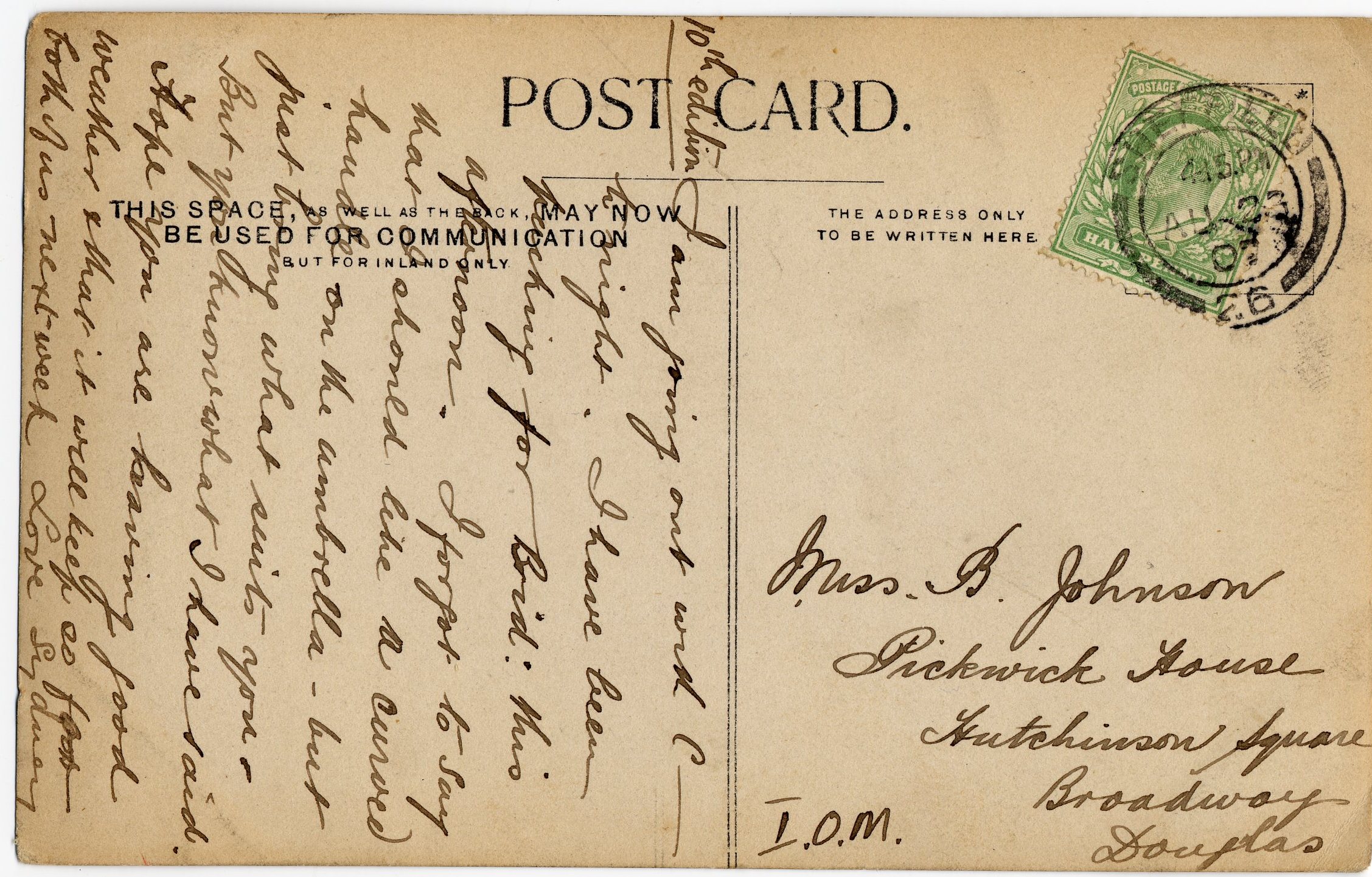
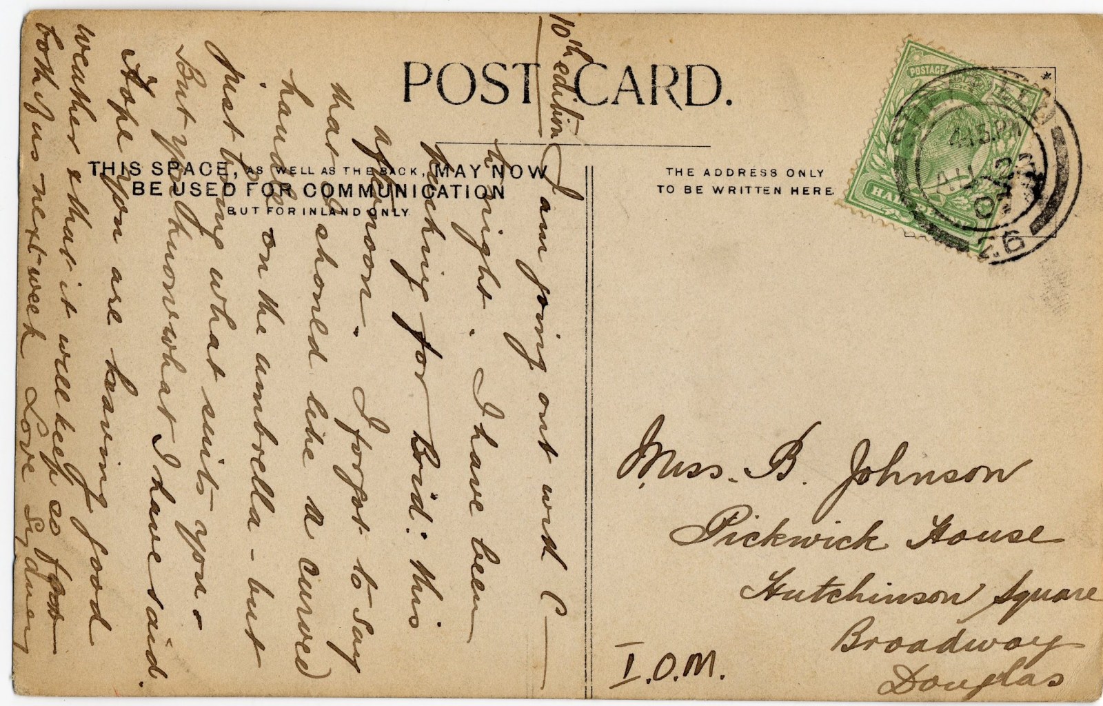
Not got a clue, part 2. Second (recently purchased) postcard; here in the forlorn hope someone can help identify the location and then someone ... Lane, junction, tree, bushes ... from Sydney to Miss B Johnson, IOM, August 1907 Attempts at transcription gratefully received; should be easy. [i may have posted letters to/from Miss Johnson ages ago on here (could they be on the "I got this"-thread ?); if so, I bought those in the late 70's, the postcards I bought last week].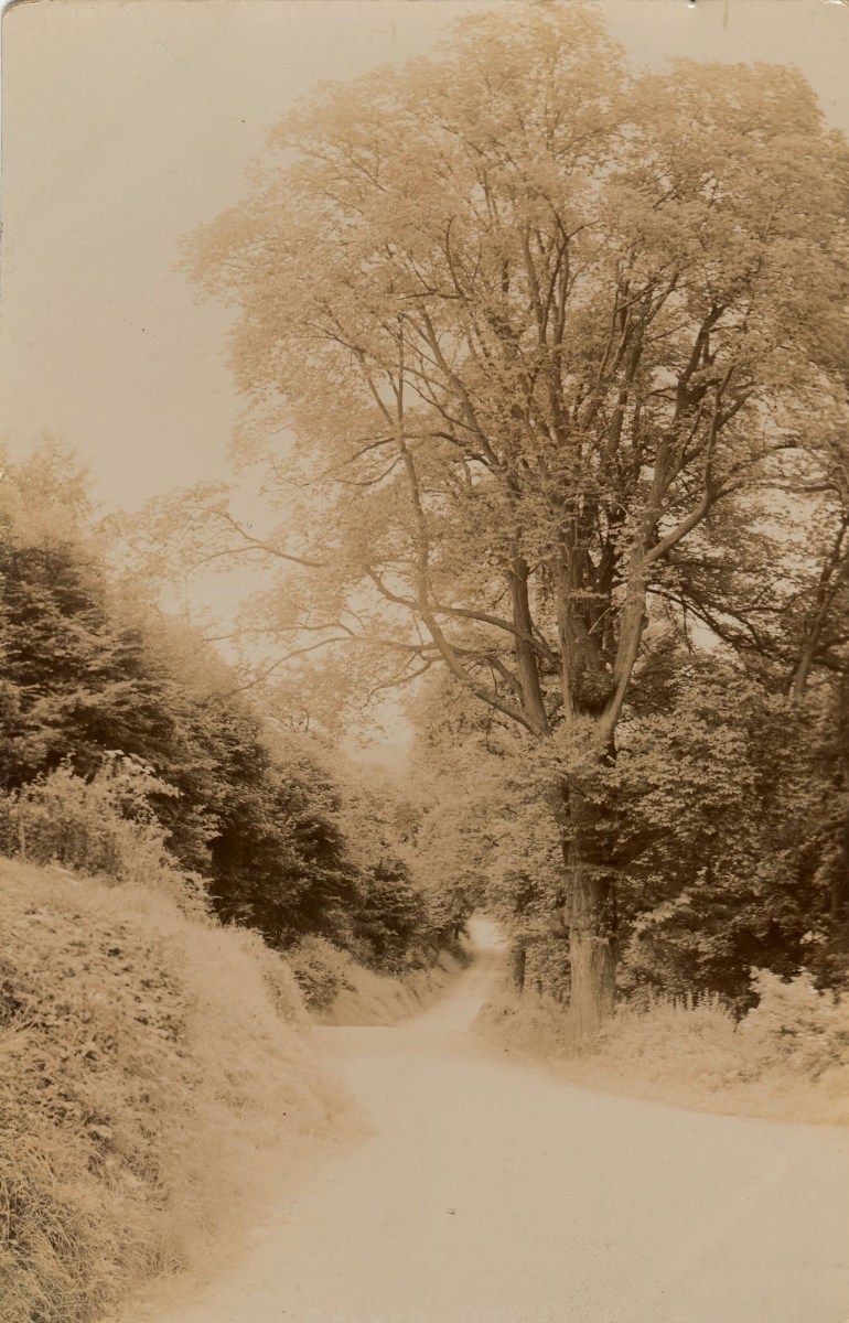
-
Sheffield & South Yorkshire Navigation Company
RichardB replied to RichardB's topic in Sheffield Buses, Trams and Trains
The Sheffield & South Yorkshire Navigation Company. Exchange Street & Canal Wharf SHEFFIELD AND SOUTH YORKSHIRE NAVIGATION ACM/SD/818, 823 1899, 1904 Contents: Land on Canal Wharf and Blast Lane http://www.nationalarchives.gov.uk/a2a/rec...2&cid=-1#-1 Papers relating to sales ACM/65434/31 1913 Contents: Sale to Sheffield & South Yorkshire Navigation Co.; property: land in Wharf Street, Sheffield Park -
I & T Hepburn and sons Long Lane Southwark London Tanners Dealers in all leather goods Page0123.pdf
-
You pretty much have it in one. The ones on Algar, and running up the hill to East Bank Rd, over Errington and Berners are all Finnegans. The ones on the bottom of spring lane, and going down Norfolk Park are VH's. On Birley moor road, as you face the tram track, with your back to the city, the ones on the left hand side are Finnegans, (Weaklands) the ones on the right which are being/ have been demolished, are VH's (Newstead) As you go down Silkstone Rd, near the Jack-in-the-box there are a number of Finnegans, as you get towards scowerdons, there is a mix of them, and the VH's. There are some Finnegans on Frith Close/ Hollinsend road, which were clad in a reddish/ terracotta tile rather than the slate-grey. They look quite nice. There are some VH's as you go up the hill toward Gleadless Townend. the badger estate at Woodhouse is mostly VH's, but there are Finnegans which have been re-clad and refurbished, which I think would have been a much better option for the ones at Arbourthorne.
-
Seems like yesterday 1974-1975 season
madannie77 replied to dunsbyowl1867's topic in Sheffield Wednesday Football Club
Truly grim indeed. I remember the game against Manchester United as myself & my dad sat in the South Stand as opposed to being in our usual haunt - the Leppings Lane end - because of the Man Utd fans' reputation at that time. A wise move, as there was lots of trouble. How did we score 4 in one game? I also remember the 3-3 draw at Notts County, where some Notts County player scored a hat-trick in a very short space of time. The sight of a three-quarter empty Kop also stands out in my mind. -
Where were the following districts of Sheffield please
RichardB replied to RichardB's topic in Sheffield History Chat
Nice find ! and you've raised a question as well ! Consider for a moment my original posting relates to the 1820's, your reply to 50 years later - might have an influence on the answers to the two questions - just a thought. My answer is definately "Old Sheffield Town", there is a strong possibility the answer to yours is part of a newer part of Old Sheffield, to me Crofts is out Scotland Street/Broad Lane way (and thats NOT the answer to my original post. -
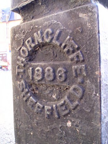
I came across this. I presume it means LBH is the manufacturer and Thorncliffe is Thorncliffe, Chapeltown. Or is Thorncliffe the Manufacturer? Either way who were they? I can't find anything. "54 Boundary - Bollards Church Path, N8 TQ305889 at junction with Tottenham Lane Date 1886 Description 3 bollards of tapered square form as above. Clean and legible casting at base. Tops nicely worn. Inscription LBH THORNCLIFFE SHEFFIELD 1886 Setting Good setting, across alley to side of Hope & Anchor PH. Source Hornsey Historical Society" (Edit: There are some others as well, described thus) "LBH cipher to front of base, with makers name in roundel with date to rear. Inscription LBH and 1883"

-
It's more likely the pub is named after Rawson Spring . Most of the area between Walkley lane and Langsett road down to Hill Bridge, before it was built up, was known as Rawson Spring (including Rawson Spring Wood and Rawson Spring farm). It was owned by the parent branch of the Rawson family who eventually acquired Wardsend.
-
I don't know for certian as my last death cert with Smilter Lane on is from 1920 but would suspect it is the same as it seems too much of a coincidence. If you really want all the info on the history of the NGH and Workhouse you should look at Lyn Howsam's books " Memories of the Workhouse & Old Hospital at Firvale" & "Life in the Workhouse & Old Hospital at Firvale". On this site there is a short section on these books and Lyn's contact mail . http://www.judandk.force9.co.uk/workhouse.html#FIR I would have thought there are copies in the Library/Archive but don't live in Sheffield so can't confirm that. John
-
1852 Thomas Parker Beerhouse, Albion Sylvester Street John Mckenzie Beerhouse, Black Lion 31 Snighill Henry Tingle Beerhouse, Black Lion 24 Bank Street Thomas Marsden Beerhouse, Brunswick Hotel and cowkeeper Edgerton Street John Hives Beerhouse, Coach and Horses and eating house 16 Waingate William Brown Beerhouse, Crown and Cushion 54 Campo Lane John Hudson Beerhouse, English Sampson 1 Duke Street, Park John Beardmore Beerhouse, Filesmiths 3 Sussex Street (is this the man with boatloads of children ??) Richard Howson Beerhouse, French Horn 7 Shude Hill Waltham Cowham Beerhouse, Great Gun 13 Wicker Jeremiah Clapham Beerhouse, Grinders Tavern 9 Spring Street William Dawson Beerhouse, John Bull 126 Rockingham Street Henry Larner Beerhouse, Millwrights' Arms Philadelphia Thomas Allott Beerhouse, Miltons Arms Little Sheffield Samuel Warburton Beerhouse, Monument Tavern 190 South Street, Park Harvey Teasdale Beerhouse, Norfolk Hotel and Springknife manufacturer 2 Pinstone Street (infamous !) Joseph Holme Beerhouse, Old Raven and table knife manufacturer 53 West Street Timothy Hawkes Beerhouse, Peel Tavern 23 Hartshead Henry Gouldthorpe Beerhouse, Pressers' Arms 30 Burgess Street Samuel Gregory Beerhouse, Prince of Wales 143 Gibraltar Street William Jessop Beerhouse, Raven 12 Fitzwilliam Street Thomas Robinson Beerhouse, Salutation 85 West Street George Rodgers Beerhouse, Shrewsbury Tavern 102 South Street, Park Mary Ridley Beerhouse, Ten Bells 31 Westbar Henry Swinscoe Beerhouse, Turf Tavern and turner 55 Westbar Henry Coward Beerhouse, Windsor Castle 70 Tenter Street George Haslam Beerhouse, Windsor Castle 50 School Croft
-
Updated main list - story behind pub name Shepley Spitfire Mickley Lane Opened 1979 Closed Span Comments from Douglas Lamb's 'Last Orders' 'A young man named Douglas Shepley, served in the RAF during the Second World War, and was a fighter pilot flying Spitfires. He was, like so many of these brave young men, only 21 years old when he died. It was during the early days of the Battle of Britain when he was shot down and killed. It was August 12 1940. He family began a collection to buy a replacement Spitfire - they succeeded and a plane called The Shepley Spitfire was built. It too was destroyed by enemy fire but the young pilot escaped.' See website : http://www.152hyderabad.co.uk/html/shepley_spitfire.html Earlier
-
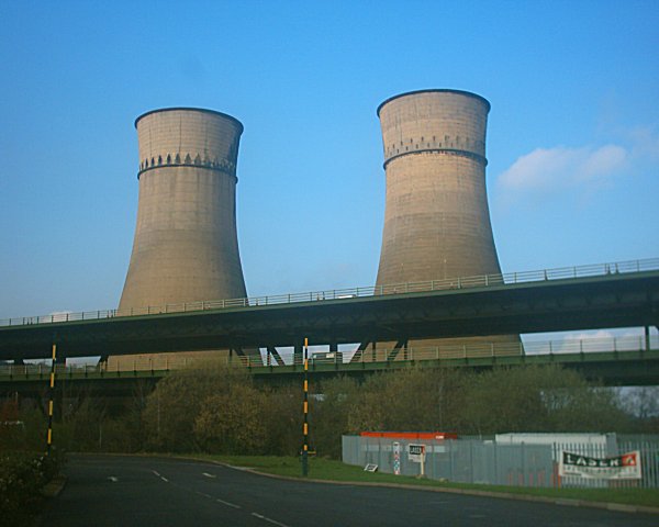
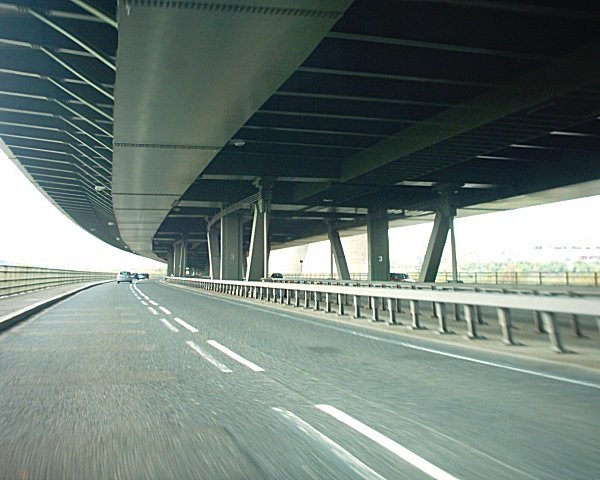
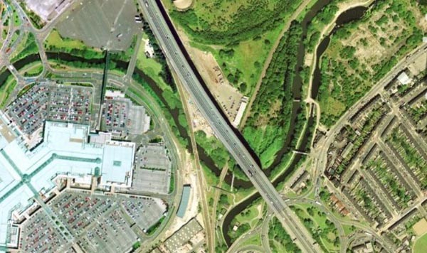
TINSLEY VIADUCT pictured above - the viaduct and meadowhall Source - http://en.wikipedia.org/wiki/Tinsley_viaduct Tinsley Viaduct is a two-tier road bridge in Sheffield, England; the first of its kind in the country. It carries the M1 and the A631 some 1033 metres over the Don Valley, from Tinsley to Wincobank. It is located at 53°25′N 1°24′W. The viaduct was opened in March 1968 and cost £6 million to build. The bridge has since been strengthened, in 1983 and again recently, with work finished in spring 2006. Although originally designed to carry 6 lanes, during the strengthening work the M1 was reduced to 4 lanes following an EU directive on load bearing. This arrangement has now been made permanent to allow the third lane in each direction to join from J34 to make the very busy junction safer. The viaduct is balanced on rollers to allow for thermal expansion and contraction, and the route weaves slightly in order to make its way past other buildings. As things currently stand, the Meadowhall Shopping Centre lies in the valley to the west, while to the east is the Blackburn Meadows sewage works. The viaduct is one of Sheffield's most prominent landmarks, made all the more so by the adjacent pair of cooling towers that were left standing for safety reasons after the demolition of the Blackburn Meadows power station. Both the viaduct and the cooling towers continue to be the subject of local controversy — many criticise the viaduct as unsafe and constantly under repair, and others consider the cooling towers an eye-sore that should be pulled down. More From Wikipedia - http://en.wikipedia.org/wiki/Tinsley_viaduct

-
COOPERS HORTON BROS. Manufacturers of Jennings & Gedges Patent American Screw Bits and Augers Astley Works, Charles Lane Sheffield Page0078.pdf
-
The park was originally the gardens of Weston Hall, built for Thomas Harrison. It was bought by the Council in 1873 and opened to the public in 1874. The Hall opened as a museum in 1875. None of which explains where the name Weston came from! Just co-incidence that it's on Western Bank. To add to the confusion, people from outside Sheffield often are unaware of the park, and there's a small sign on a lamp post at the top end of the Children's Hospital that simply says 'Weston Park' and points to the park gate across the road. Unfortunately this confuses drivers and taxis from out of town who are looking for Weston Park Hospital, which is widely referred to just as 'Weston Park', with the result they see the sign and turn right into Mushroom Lane, usually ending up in the car park of the University Psychology dept!
-

Blitz-era ruins.
dunsbyowl1867 replied to Waterside Echo's topic in Sheffield War Years and The Sheffield Blitz
I hear they are going to start on Brammall Lane soon! http://www.picturesheffield.com/cgi-bin/pi...ff.refno=s01012 -
Yes, Still there in the 1959 Kellys. I know Tom Cross Lane was the old name for Brunswick Rd. Where does New Brunswick Street fit in ?
-
Merry Heart 110 Spital Street (Tom Cross Lane) Open 1854 Comments 1854 earliest found so far 1854 Henry Steel 1856 Henry Steel 1861 Henry Steel 1862 Henry Steel (18 New Brunswick Street) 1881 Mrs Jane Higginbottom (110 Brunswick Road) 1893 George Stacey 1901 John Platts (110 Brunswick Road) 1905 Percy D Shaw 1911 Joseph Beevers (110 Brunswick Road) 1919 Joseph Beevers (110 Brunswick Road) 1925 Herbert Whitehead 1948 John William Wilson 1951 John William Wilson Made it to 1951 at least.
-
The leftmost window visible is the Gents toilets, a little left of that, out of picture is the gate that had to be kept locked one day a year. It took you up past the remains of the Don Bakery on the right and the Church on the left. Unless it was 1969 in which case the Pub was replaced by Tesco (opened by Bo Monkhouse). Carrying on the un-named lane it brought you out between Woolworths and the electrical store; the next corner (50 yards to the left was Burton's shop on the corner.
-
First one spot on, you can see the Church where Tesco was which became Wilkinsons (between the Shakespeare and the Old Blue Ball. Second one looking towards Hillsborough Park, Hillsborough Inn on corner of Holme Lane.
-
It remained closed due to argument. "Originally built on the outskirts of the town, on land bounded by Pinson Lane (later Pinstone Street) and Alsop Fields (later to become Norfolk Street) The building of St Paul's Church was funded by public subscription in 1720 and 1721 with the first stone being laid in 28th May 1720. The dome was added in 1769 It was made possible by a gift of £1,000 and the promise of £30 a year for the Minister from Robert Downes, a Sheffield goldsmith, in return for him and his heirs having the right to appoint the minister, and it was to be a Chapel of Ease to the Parish Church. The then Vicar of Sheffield objected on the grounds that since it was a Chapel of Ease to his church he had the right to appoint the Minister. At the same time the Patron of the Parish Church, William Jessop, claimed that as such he should automatically be Patron of St. Paul's. The argument continued for nearly twenty years, during which time the church remained locked and unused. Things were brought to a head in 1739 when Robert Downes threatened to open the church, as he was legally entitled to do, " as a meeting house for Protestant Dissenters". As a result a compromise was agreed under which the Vicar was to be the Patron, but the first Minister was to be Robert Downes nephew, John Downes. And so the church was actually consecrated on 2nd May 1740, twenty years after the laying of the first stone" www.chrishobbs.com
-
As you look at a map, the corner we have completed is the northeast corner. The 2 western corners both go round onto Holme Lane and the southeastern corner is on Langsett Road as it comes back to town past the barracks. Unfortunately Stuart, like you I don't live in or know this area too well. Furthermore, as the Google picyures are fairly recents (so they are NOW pictures) where are we going to get some THEN pictures from? In 1974 I only took that one picture of the northeast corner. :(
-
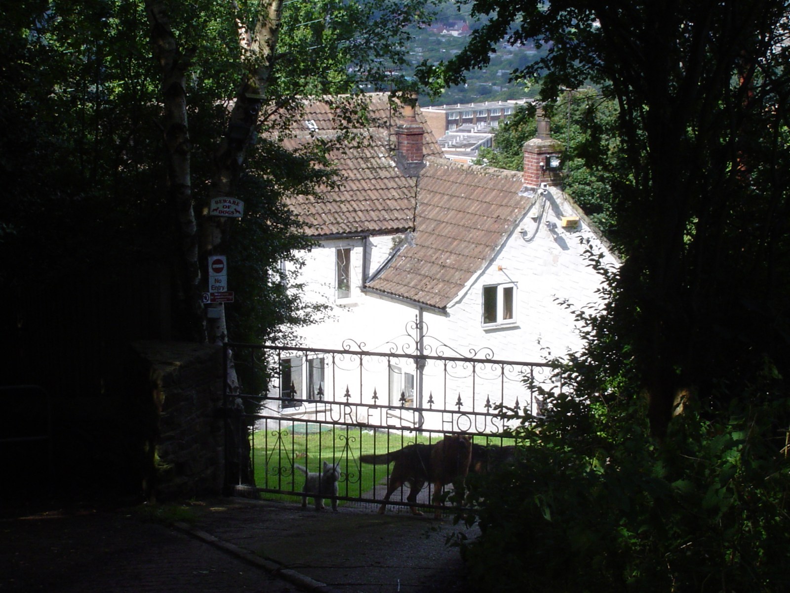
This path finally end right in front of Hurlfield House on the lane which was blocked off to traffic. Hurlfield House is guarded by a pack of dogs behind its gates which bark fiercely every time anyone walks along the path. Got a photo of the house but from a safe distance (notice the dogs). Wasn't brave enough to go snooping around for any old school ruins.
-
The junction of Hurlfield Road with Arbourthorne Road (which is the main road which swings around to the right) and Toll Bar Road (a narrower road which continues straight on). The unidentified buildings on SteveHB's labelled Google map would appear to be that row of 3 cottages in the left of centre of the picture. Since this picture was taken just before I went on my holidays the road junction has already been altered, A give way and junction at the top of Arbourthorne Road, with Hurlfield Road now doing what it did originally as Hagg Lane, continuing on along Toll Bar Road into Myrtle Springs. At least this gets rid of a very nasty blind bend which many motorists went round far too fast without a thought of what could have been around the corner.
-
Almost opposite the school on the other side of Hurlfield Road is the old water works building, although there is no visible evidence of the "Hagg Lane Tanks", the water tanks which once stood here at the highest point. They are long gone and replaced with new housing.
-
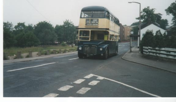
And here is WLT584 at Lane End Chapeltown