Search the Community
Showing results for 'coal pit lane'.
-

Shirland Lane Sheffield - The Full Monty Filming Location
Sheffield History posted a topic in The Full Monty Filming Locations
This shot of our characters walking up a hill was incredibly difficult to pin down but I did it (eventually!) This shot was achieved by the cameraman being quite a way away from the actors but zoomed right in on them, and the 'hill' wasn't actually a hill they're walking up but was the hump of a bridge between the cameraman and the actors! This actual Full Monty Filming Location is Shirland Lane which is in the Attercliffe/Darnall area of Sheffield The pub seen to the left is no longer a pub See below for the actual Sheffield location and what it's like now!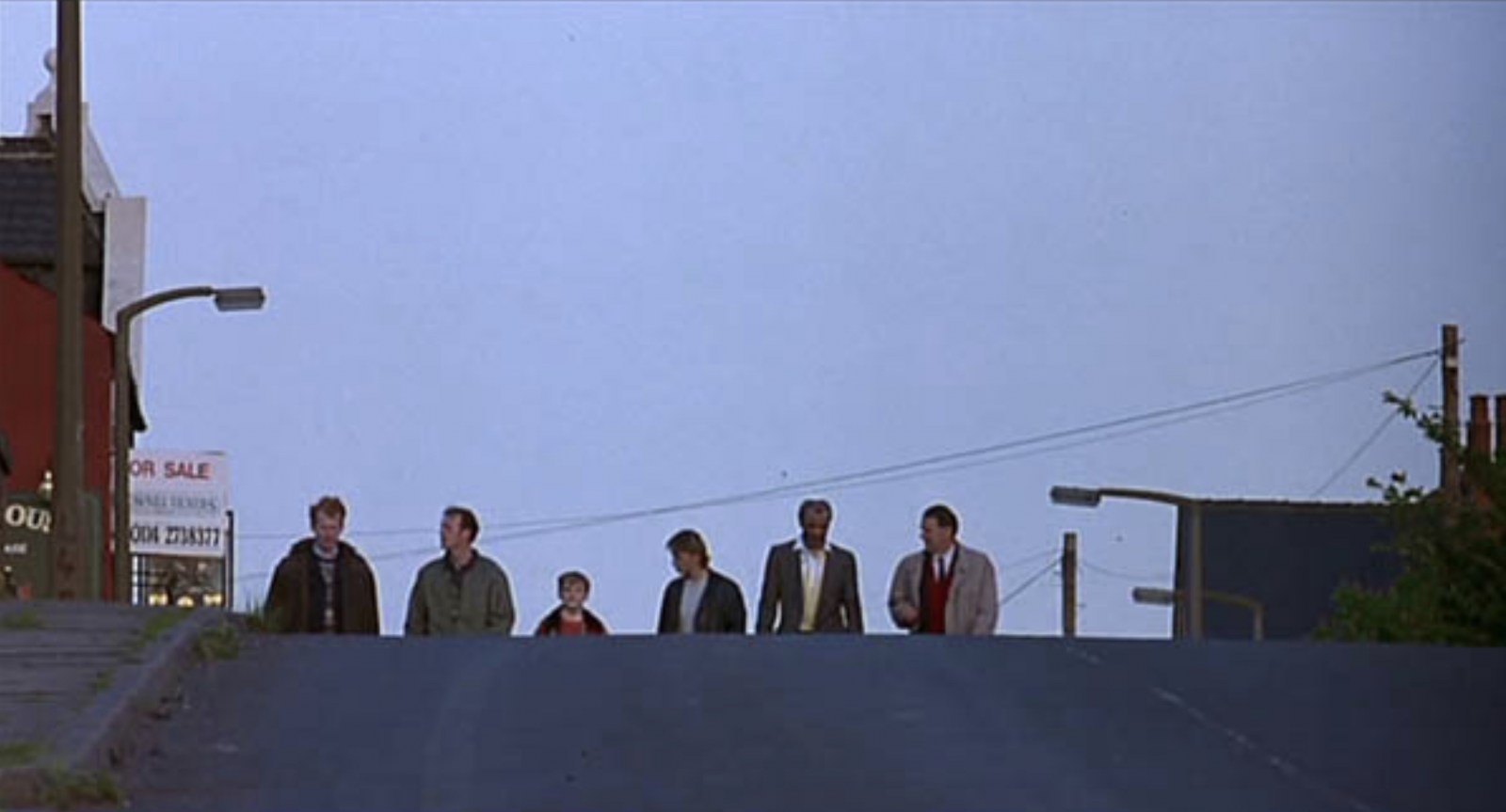
-
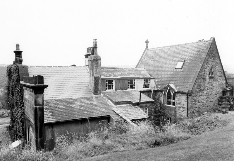
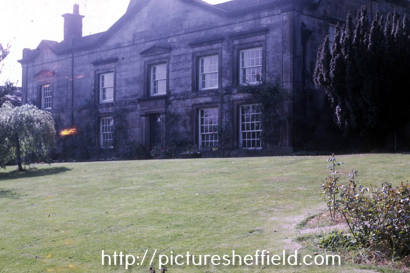
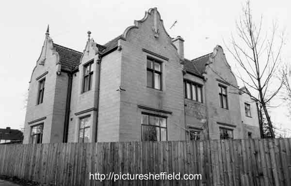
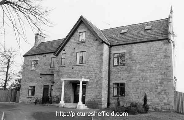
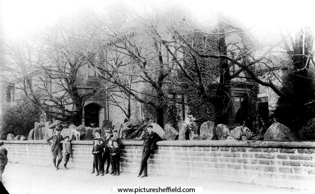
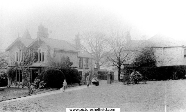
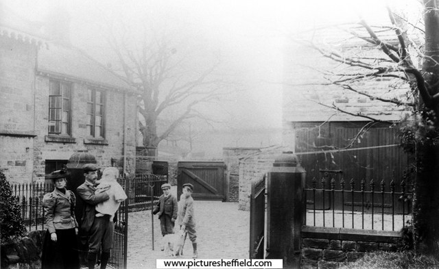
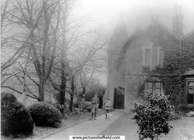
Revell Grange, Bingley Lane. August 1991.Picture Sheffield No s27895 Front Elevation. Picture Sheffield No. s27893 Revell Grange, seat of the Revell family who moved there from Nethergate Hall in 1742, they were Roman Catholics, and the private chapel was in continuous use as a Mass centre until 1828, mission reopened 1855's. See The Lord's House, a history of Sheffield's Roman Catholic Buildings 1570-1990 , Denis Evinson Ref: 282.4274 S. also Transactions of the Hunter Archaeological Society Vol 9 1964-69 page 196 S https://www.picturesheffield.com/frontend.php?keywords=Ref_No_increment;EQUALS;s27896&pos=4&action=zoom&id=30630 Rear elevation and Chapel, Revell Grange, Bingley Lane. s27894 https://www.picturesheffield.com/frontend.php?keywords=Ref_No_increment;EQUALS;s27897&pos=5&action=zoom&id=30631 Stables, Revell Grange. https://www.picturesheffield.com/frontend.php?keywords=Ref_No_increment;EQUALS;s27898&pos=6&action=zoom&id=30632 https://www.picturesheffield.com/frontend.php?keywords=Ref_No_increment;EQUALS;s27899&pos=7&action=zoom&id=30633 Revell Grange, Bingley Lane, Stannington front elevation. July 1974. w01504 From the West End. w01503 Photographer: David Cathels Revell Grange Grade II Listed Building. 8th August 1985. https://historicengland.org.uk/listing/the-list/list-entry/1132865 https://en.m.wikipedia.org/wiki/Revell_Grange https://cityseeker.com/sheffield/878723-revell-grange


-
It would probably have been Gentian Violet, an antimicrobial dye derived from coal tar. It's still around... but it's use much restricted in the UK nowadays after clinical research and availability of better alternatives to prevent/treat infection.
-
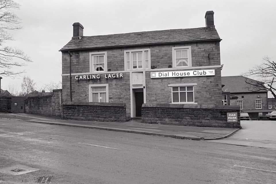
THE DIAL HOUSE CLUB LOCATION Ben Lane, Sheffield 6
-
Link to: Owler Lane High School. https://www.sheffieldhistory.co.uk/forums/topic/13344-owler-lane-high-school/
-
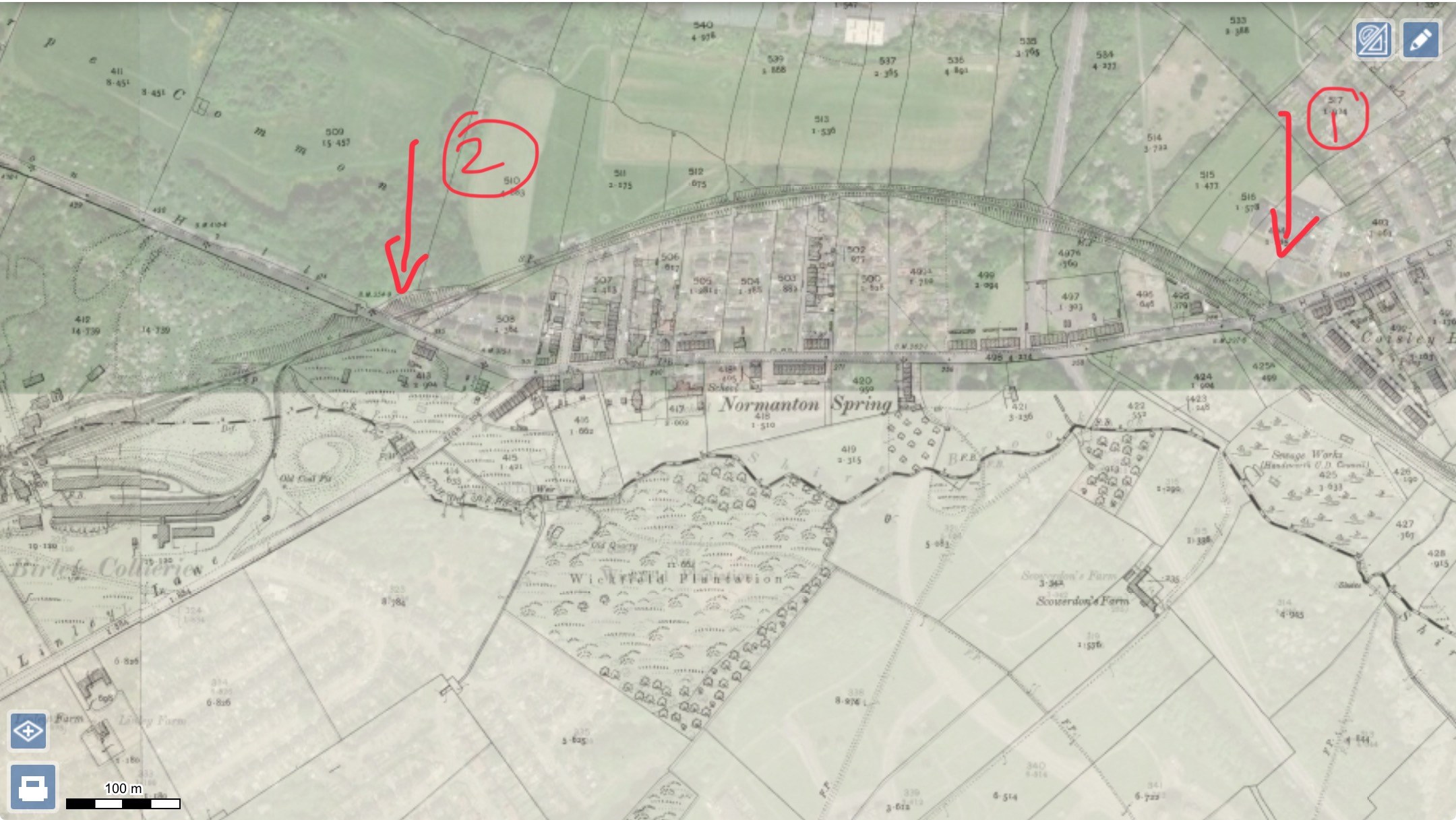
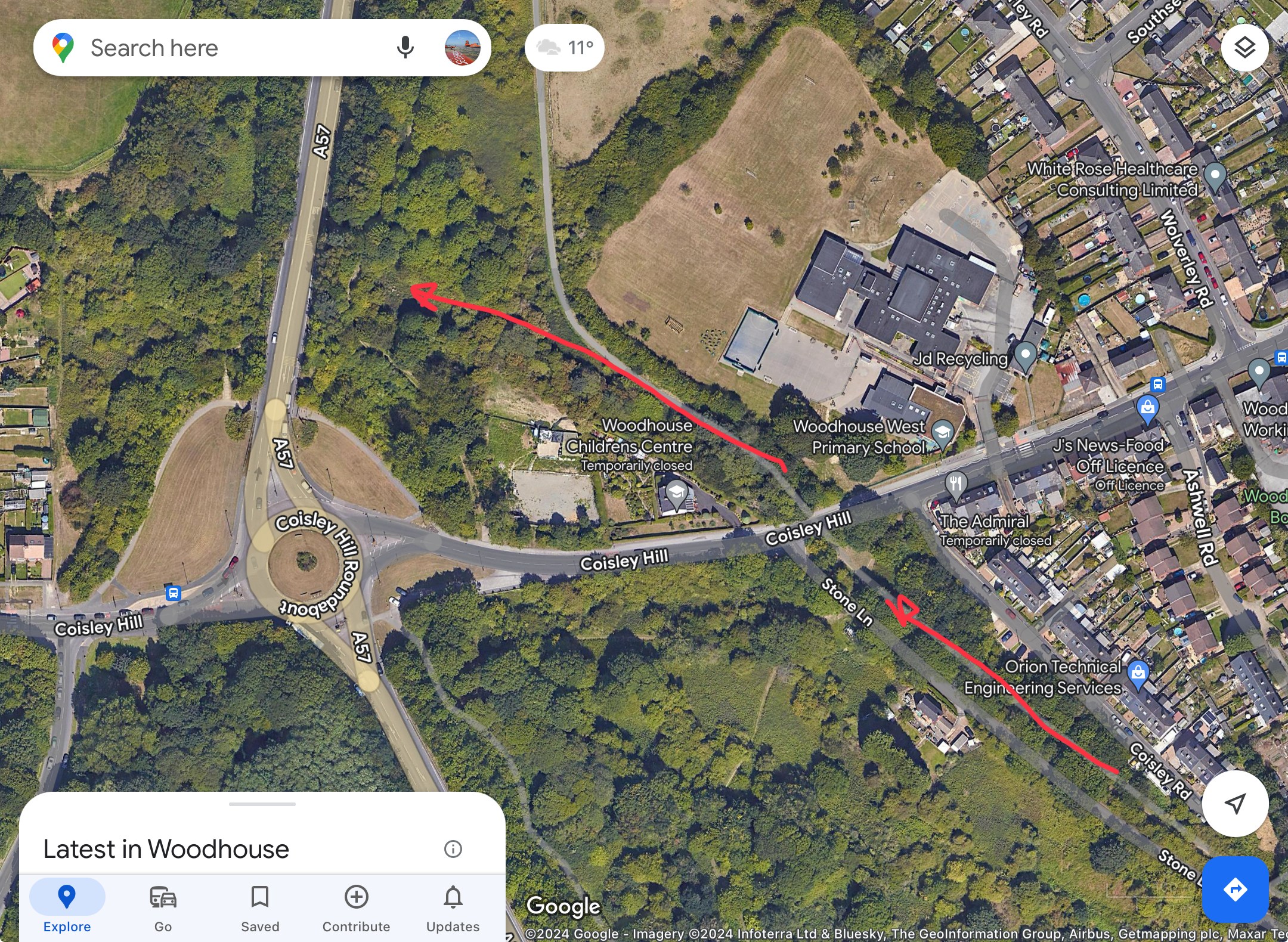
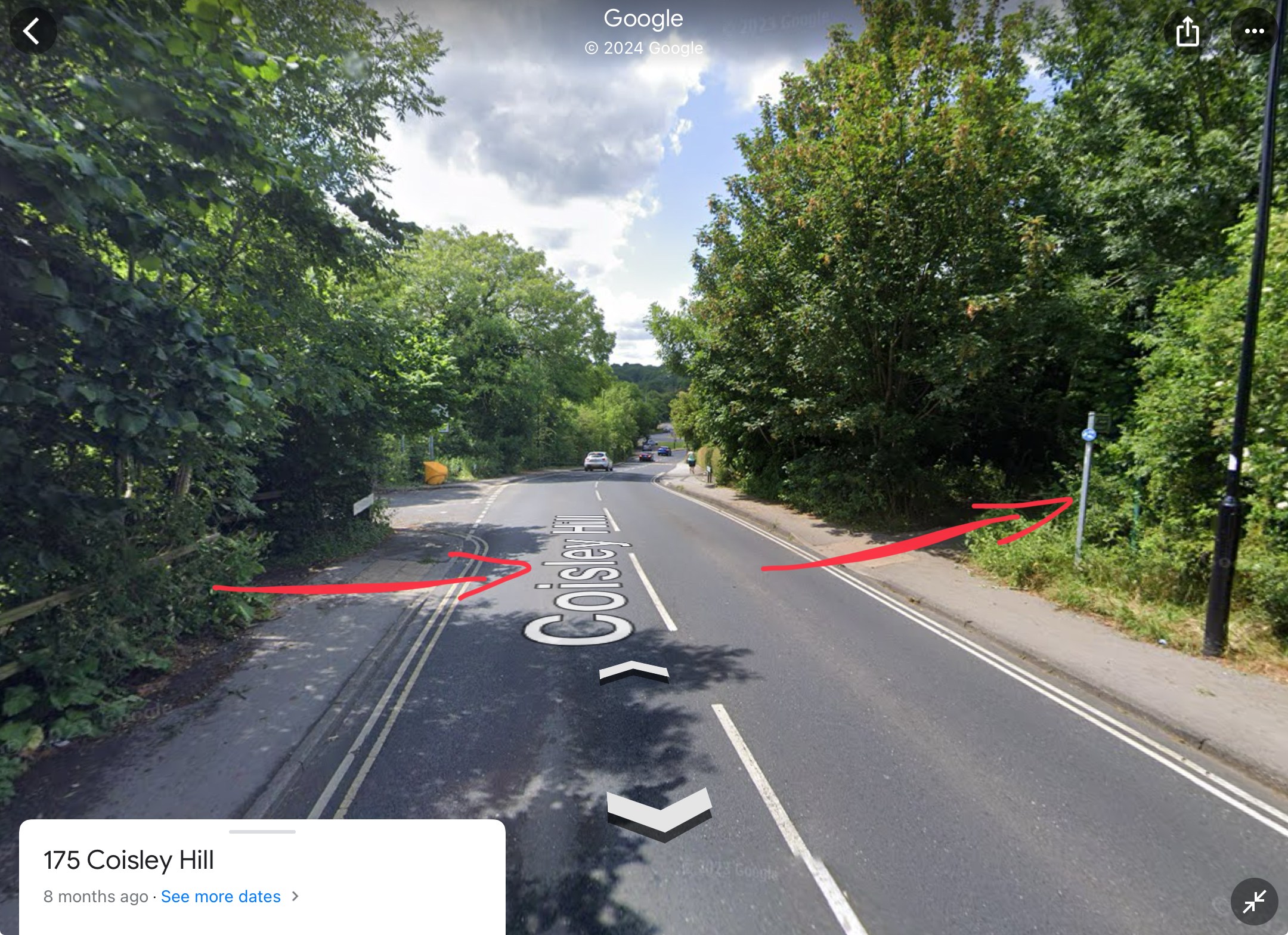
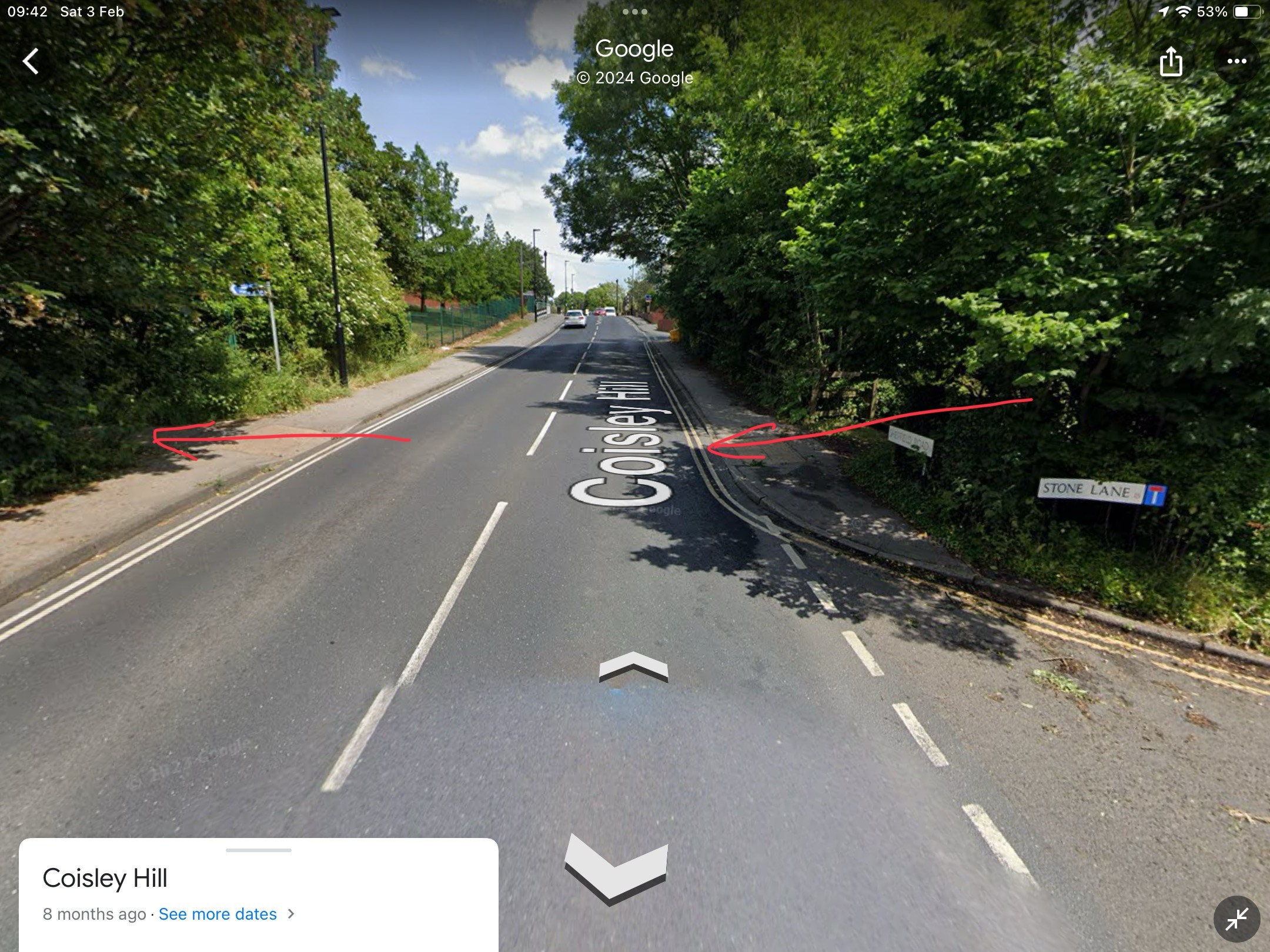
Birley Collieries Branch Line
History dude replied to Paolo Coopio's topic in Sheffield Buses, Trams and Trains
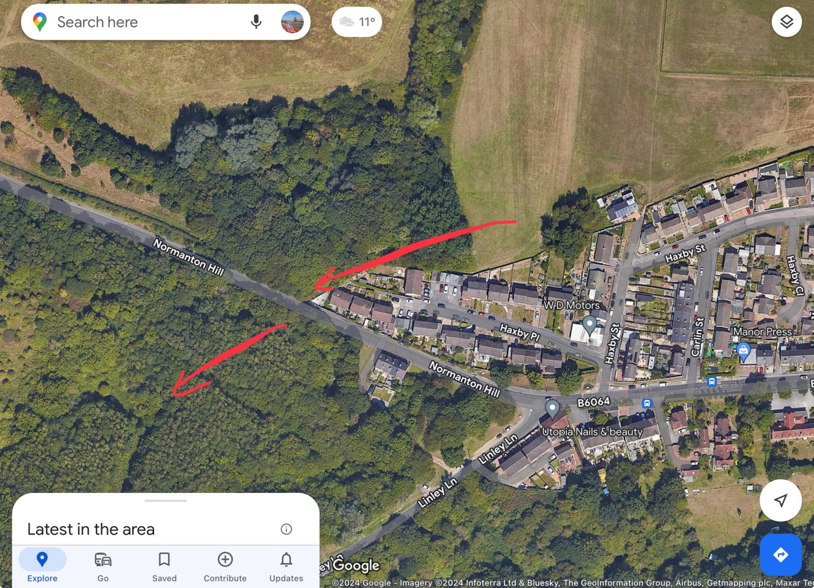
If you look at R Longden's map and at Fields 504 and 505 at the top end, you can see that the cutting cuts away and indicates a bridge over lane/path. If you look in the background of my photo, you can see the school building of City School, which ties in nicely with the modern academy on the modern satellite image and following it down the large green blob of trees might indicate that the bridge is still there. So the "tunnel" is not a tunnel, but a bridge with the railway line on top and the path below it. I have had a look around Google Street View, and modern buildings now block the original view I took in the 1980s. However, there is a footpath at the back which can be accessed via Haxby Street and the cul-de-sac off it. Near where the large building that crosses over the boundary line of the estate.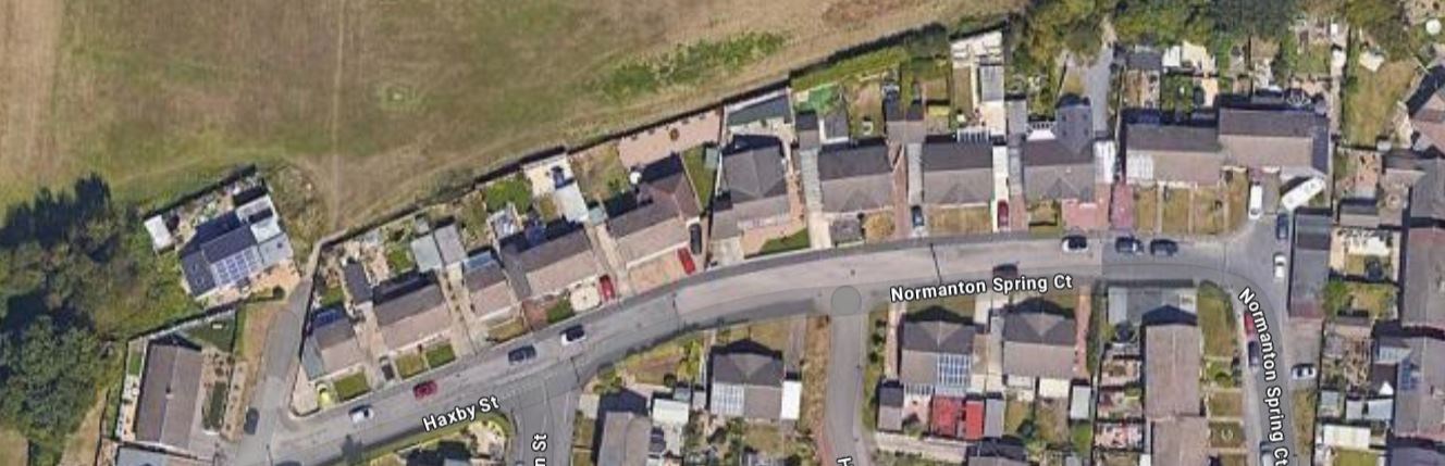
-
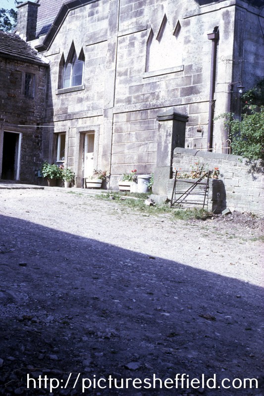
Greno House, School Lane, Grenoside. s05723 Advertisement for Education at Greno House near Sheffield. G. Rider BA of the University of Cambridge receives into his house a limited number of young gentlemen whom he prepares for the Universities and for the Professional or Commercial pursuits. Terms per annum. The pupils under eleven years of age 30 guineas. For those above that age 35 & 40 guineas. NB. No extra charge except for washing. The house is situated in a very beautiful & healthy part of Yorkshire four miles from Sheffield and four miles from Wortley. Coaches pass the House daily. A quarters notice and a quarters board previously to the removal of a pupil. Greno House, School Lane, Grenoside, February 1949. s05717 s05720 View from East. View from North East. https://www.picturesheffield.com/frontend.php?keywords=Ref_No_increment;EQUALS;s05721&pos=7&action=zoom&id=9134 View from South West. https://www.picturesheffield.com/frontend.php?keywords=Ref_No_increment;EQUALS;s05722&pos=8&action=zoom&id=9135 The Well. https://www.picturesheffield.com/frontend.php?keywords=Ref_No_increment;EQUALS;s05719&pos=5&action=zoom&id=9132 Pheasant Rearing House. https://www.picturesheffield.com/frontend.php?keywords=Ref_No_increment;EQUALS;s12031&pos=9&action=zoom&id=15037 s37340 Greno House, School Lane, Grenoside, July 1989. Latterly converted into 5 seperate dwellings. Former Stables. https://www.picturesheffield.com/frontend.php?keywords=Ref_No_increment;EQUALS;s37348&pos=2&action=zoom&id=73924


-

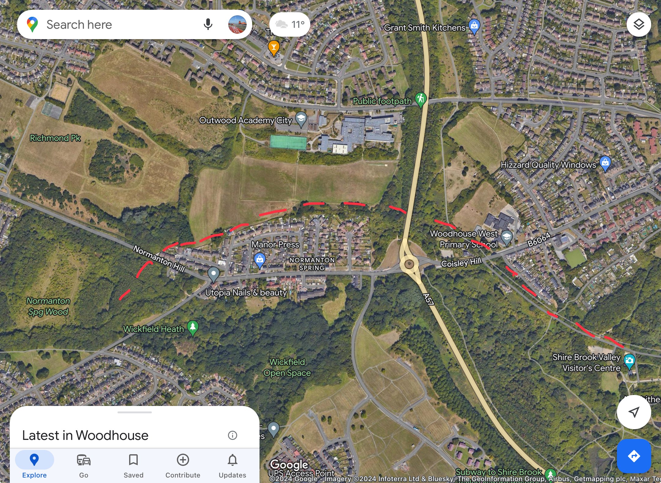
Birley Collieries Branch Line
Lemmy117 replied to Paolo Coopio's topic in Sheffield Buses, Trams and Trains
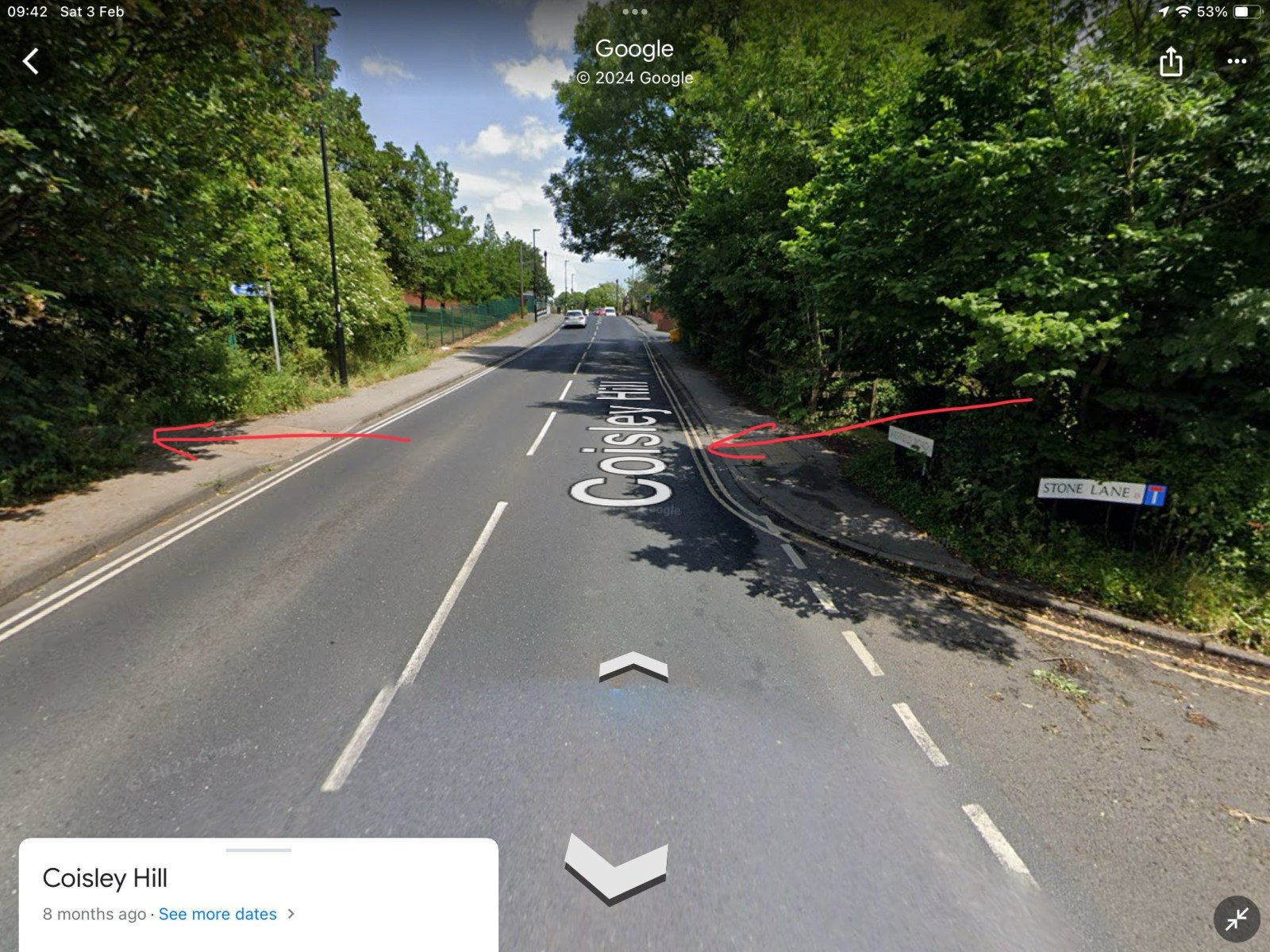
Thanks to that map it seems there was a bridge on Coisley Hill which I was not aware of. From the current pictures it seems the cutting has been filled in next to Stone Lane to bring the path up to road level. That's the good thing about this site, you learn something new every day! -
The Hole In The Road Sheffield
Stasro replied to Sheffield History's topic in Sheffield History Chat
two comments to add to the discussion - 1 This area of the city Centre took quite a pounding during the war with Marples Hotel on Fitzalan Square taking a direct hit and the old C&A building being bombed out. That is why there was a row of single-story shops across the end of what was Change Alley. It took many years' work to put that all to rights. 2. The delays due to the old coal seam were due to the Coal Authority having "first dibs" on any coal found in excavations and they always took their time deciding whether they wanted it or not. -

Birley Collieries Branch Line
RLongden replied to Paolo Coopio's topic in Sheffield Buses, Trams and Trains
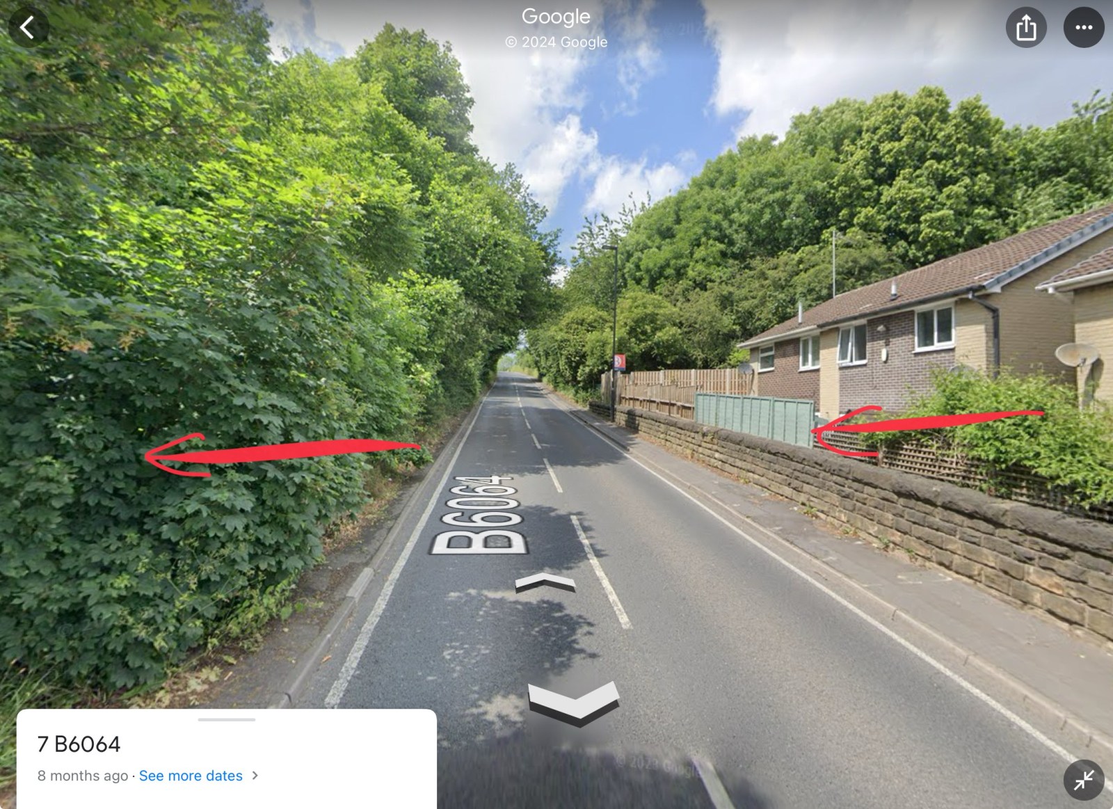
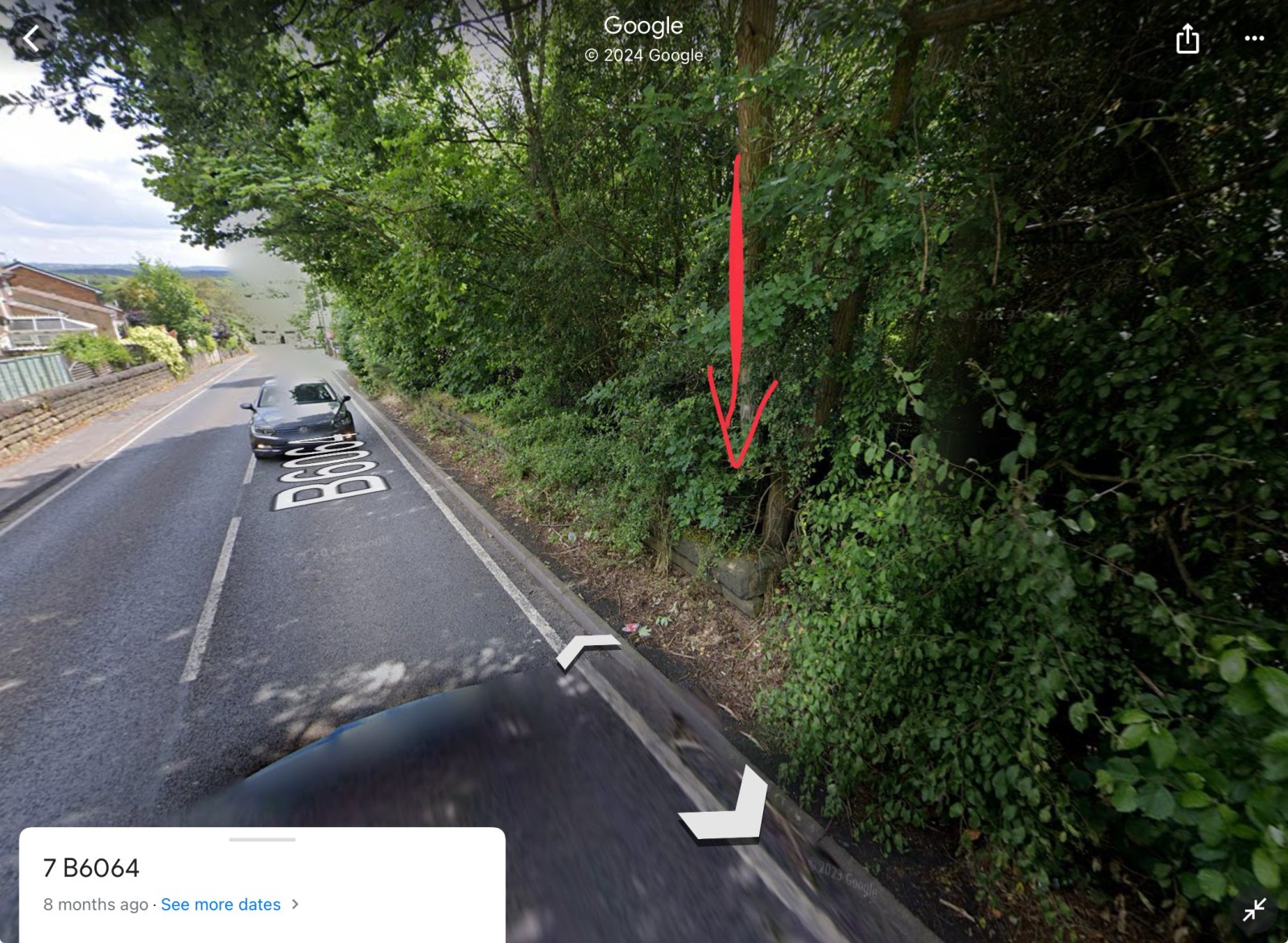
The line cut the road at 2 points. 1) Coisley Hill and 2) Normanton Hill. 1) You can see where the track bed was, as it’s now a part of the Trans Pennine Trail. It crosses Coisley Hill just up from Stone Lane, where the kerbs have been dropped either side 2) Just above the end house on the right going uphill, you can see the wall either side and the ‘drop’, where the tunnel cut under the road. Assume the level of the ground was backfilled to accommodate the houses, though if you peer over the wall/fence, it is still well below road level The trace of the line can still be seen in the vegetation, wall and property boundaries Hope this helps to visualise the route and crossing points?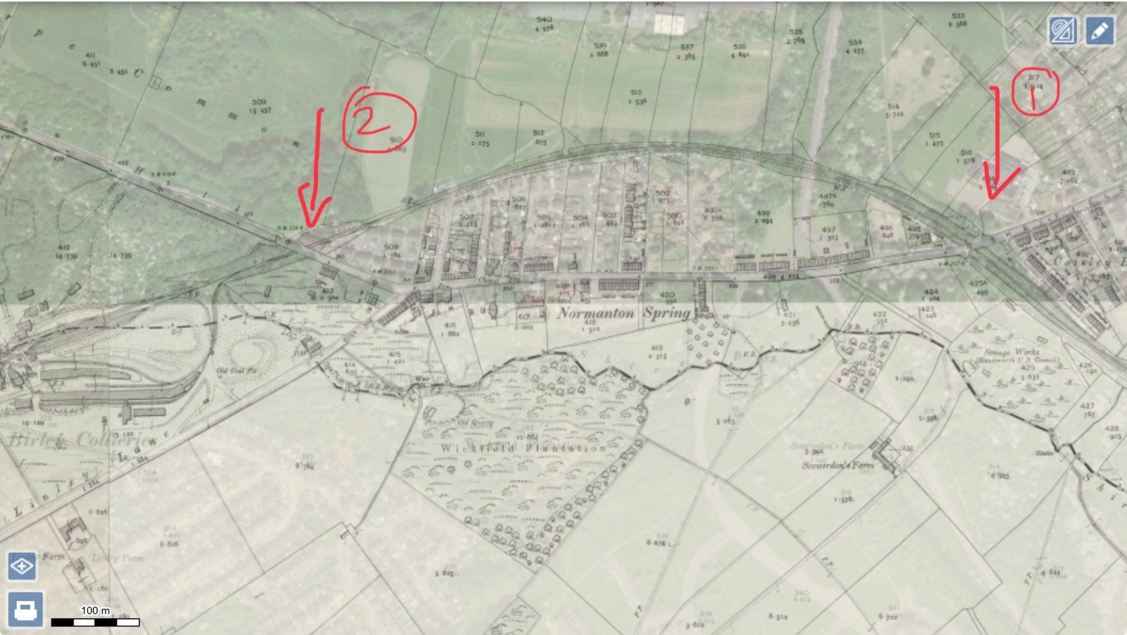


-
Former horse trough from Hunter's Bar, now in a field bounded by Hangram Lane and Cottage Lane. Hangram Lane Farm in background. June 1996. https://www.picturesheffield.com/frontend.php?keywords=Ref_No_increment;EQUALS;t02239&pos=4&action=zoom&id=32950 Snowy Sunset, Whiteley Wood Green, Sheffield. (The Old Horse Trough Was Formerly At Hunters Bar.) https://hedgerow.co.uk/image/type-general/searchstring-category%2525253ADERBYSHIRE/imgid-2760/ Horse Trough at Hunter's Bar. t08362 Entrance to Endcliffe Park, Ecclesall Road from Hunters Bar showing old horse trough (centre) 26th February 1933. Roundabout, Hunter's Bar, Ecclesall Road, showing the old horse trough. Entrance to Endcliffe Park, centre. 17th January 1955. https://www.picturesheffield.com/frontend.php?keywords=Ref_No_increment;EQUALS;s17488&pos=10&action=zoom&id=20198 Hunter's Bar showing Horse Trough 1904. https://www.picturesheffield.com/frontend.php?keywords=Ref_No_increment;EQUALS;s17486&pos=24&action=zoom&id=20196 Hunter's Bar, Ecclesall Road, from Junction Road. Endcliffe Park, left. Horse Trough, centre. https://www.picturesheffield.com/frontend.php?keywords=Ref_No_increment;EQUALS;t00986&pos=29&action=zoom&id=31812

-
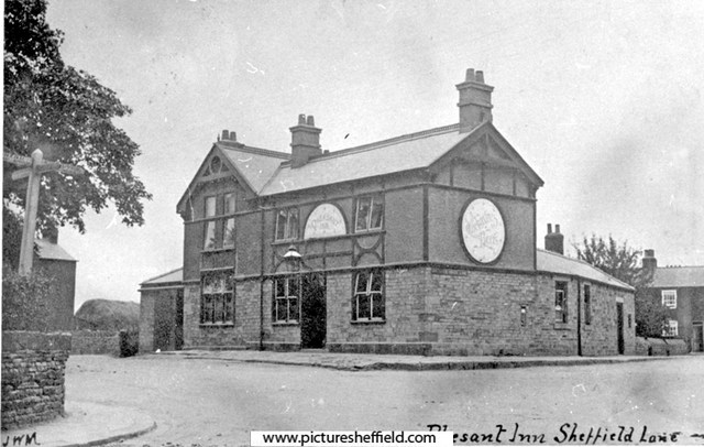
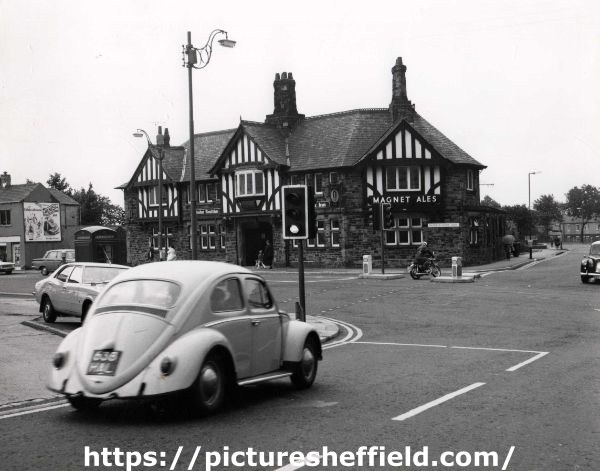
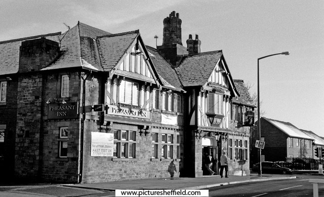
s06970 The earlier Pheasant Inn, Barnsley Road, Sheffield Lane Top. u11821 Pheasant Inn, No. 822 Barnsley Road, Sheffield Lane Top. 1973. Photographer: SCC City Engineer and Surveyors. c00564 Pheasant Inn, No. 822 Barnsley Road, Sheffield Lane Top. 19th November 2004.
-
Norwood Grange, junction of Longley Lane, Herries Road and Norwood Grange Drive. 15th March 1983 s38698 December 1988.s38697 December 1988s38696 Norwood Grange now a Care Home. https://www.norwoodgrange.co.uk/
-
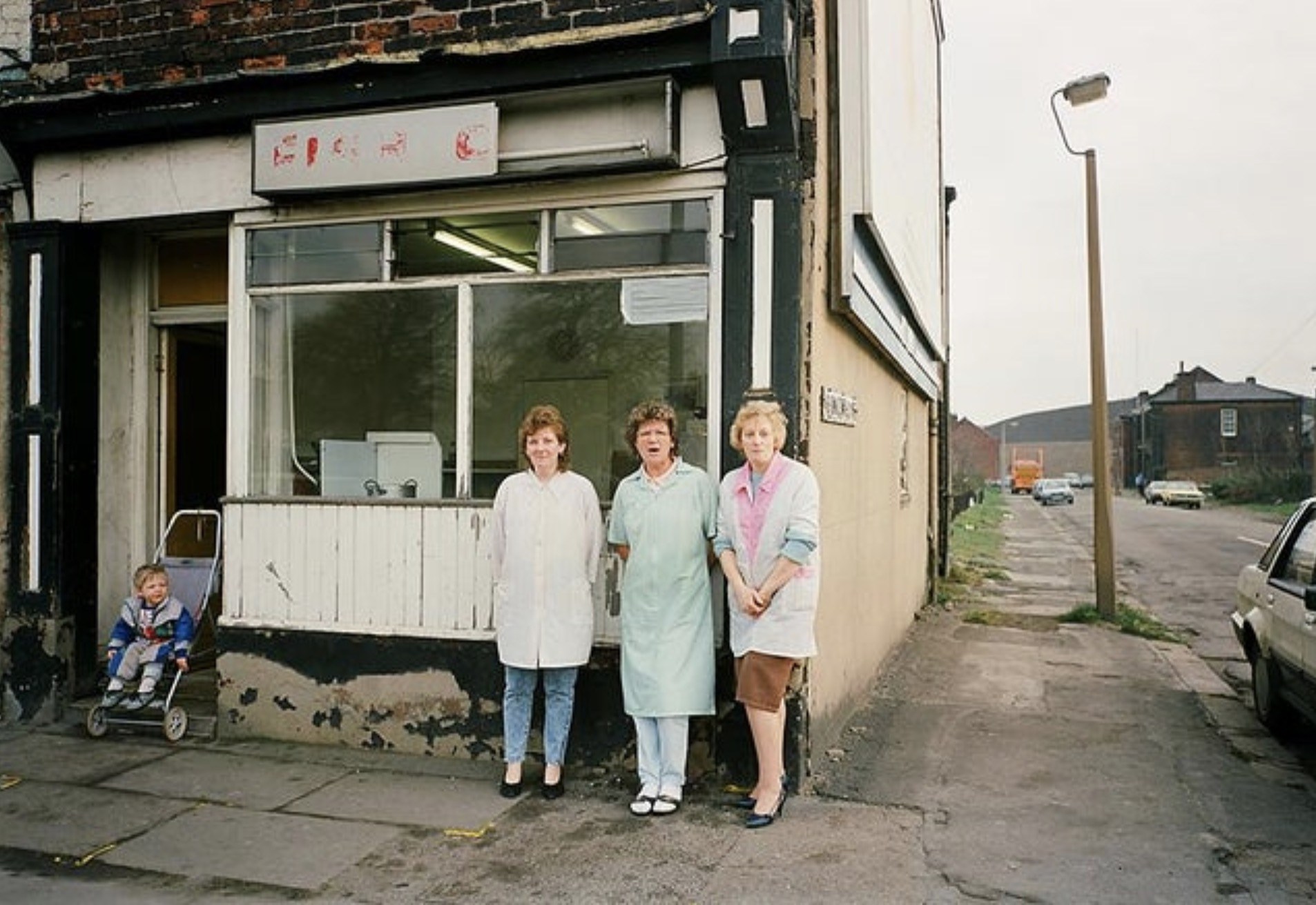
Fish and Chip shop on Whitworth Lane / Attercliffe Common
Sheffield History posted a topic in Sheffield Restaurants & Cafes
Who remembers this fish and chip shop in Atterclffe? Is was situated right on the corner of Attercliffe Common and Whitworth Lane in Attercliffe. In the background you can also just about see the old Attercliffe Police Station
-
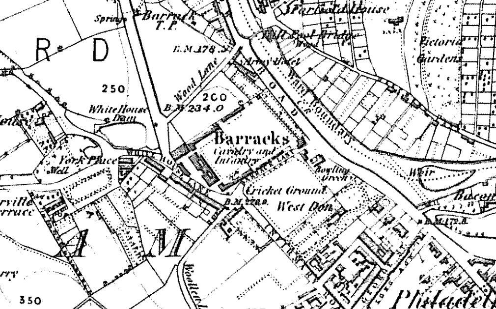
http://www.picturesheffield.com/cgi-bin/pi...ff.refno=s07451 http://www.picturesheffield.com/cgi-bin/pi...ff.refno=s18668 Apparently this property survived until 1992 and the widening of Pensitone road. It was the only survivng remnant of the old cavalry barracks built in 1792/4 and originally served as the barrack infirmary and officer's quarters. The old barracks site was bought by a partnership of builders in 1855 and used for the housing between Wood street and Barrack lane, incorporating Bertha street, Flora street, Gertrude street and Thirza street; - named, presumably, after female relatives of the builders. Part of the site was used to extend Infirmary road into Langsett road and so avoid the little detour up White House lane, which, according to a report in the Sheffield and Rotherham Independent at the time, was "exceedingly inconvenient".
-
The question was raised where Forge Lane was in the Pond Street area. Thanks to Archives and Local Studies who are digitilising maps making them available on line through the Picture Sheffield website, thought this may prove helpful. Part of Shude Hill is also marked. Please note the spelling is as it is on the map. A map of the dams, goights and other works belonging to the Pond Forge Co together with some other intermediate properties. 1820. Boardman's Bridge, wear [weir], Porter Brook, goight, River Sheaf, Upper Dam, Sheaf Lane, bridge, Upper Forge Wheel, dam, Upper Forge, Sheaf Mill, steam engine, Lower Forge, grinding wheel, arched goight, tail goight, Shude Hill, Hospital Bridge, hospitals, Sheaf Bridge, Castle Orchards Wear [weir], River Dun [River Don], Pond Street, Forge Lane, Pond Well Hill. Late Joseph Ward, John Hounsfield, Josiah Blackwell, late Abraham Wright, S. Woodcock and Sons, Joseph Blackburn, Thomas Mearbeck and Co., S. Rawson and Co. [?Thomas Rawson and Co], Joseph Shimmeld, John Vickers, Sheffield Gas Light Co., S. and S. Darwin, Sarah Beeley, Widow Beardsall, John Hale, Widow Badger, and J. B. Ward. https://www.picturesheffield.com/frontend.php?keywords=Ref_No_increment;EQUALS;arc04213&pos=13&action=zoom&id=105197 And another map, a bit harder to read but the tenants/owners of the properties are named in the notes.... Thank you Archives and Local Studies. https://www.picturesheffield.com/frontend.php?keywords=Ref_No_increment;EQUALS;arc04212&pos=12&action=zoom&id=105190
-
Any ideas why Cockshutts Lane in Oughtibridge is sometimes referred to as Jossey Lane (maybe Jossy) ? On all the maps I can view, it is always shown as Cockshutts Lane.
-
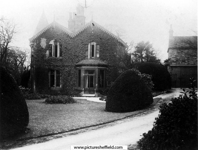
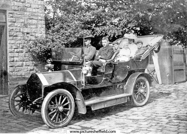
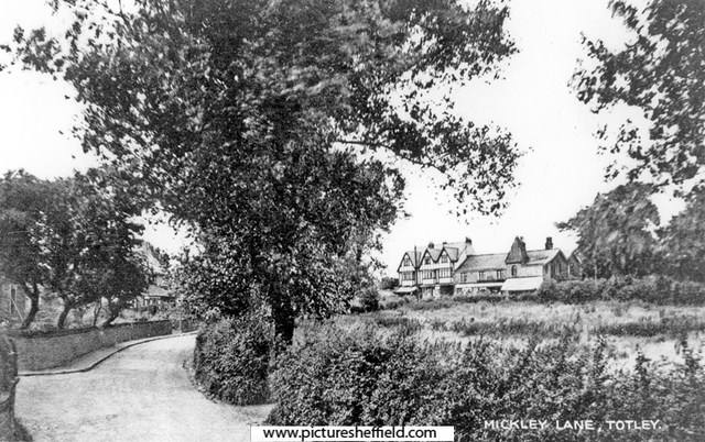
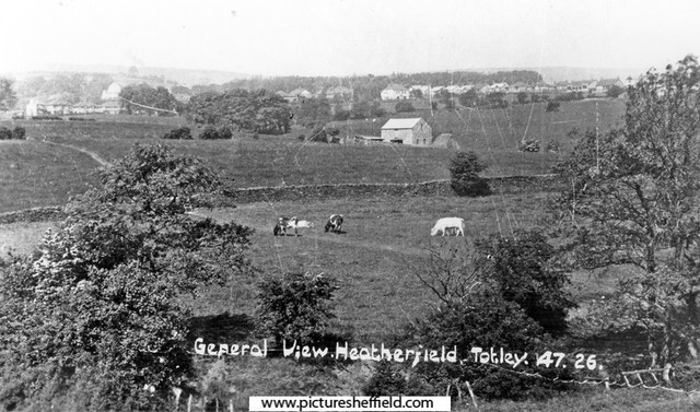
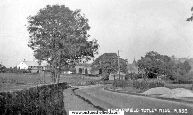
Greenoak House, Baslow Road, Totley At the time of the photographs (about 1900), rented from Ebenezer Hall of Abbeydale Park, by Athol Capron and family. The house was formerly a Farm and Greenoak Inn. Converted and extended into a family residence in the late c19th. See 'Totley District in Old Photographs', by Brian Edwards, Cat. No. 942.74 S. Mickley Lane, Totley, with a view of the buildings on Baslow Road including Greenoak House (the former Greenoak Inn). The smaller part in the middle was the original Greenoak Inn, built 1812. The extension on the right was added much later when it became Greenoak House. The part on the left was added early 1900's. s11439 The family of Athol Capron (consisting of his wife, 4 children and donkey) moved into Greenoak House in 1899, paying £90 p.a. rent to Ebenezer Hall of Abbeydale Park. Greenoak House from Baslow Road. s06092 Family of Athol Capron in Humber car at Greenoak House, Maurice (front seat), John (behind), Clare (on lap) and Gérard. 1906. s09007 From Donkey Field. Mrs. Capron and Maurice.s06089 Greenoak House from Baslow Road. A. C. Capron, Maurice (son) and Roy (dog) with village boys.s06087 Mr and Mrs Athol Capron with children, Maurice (with Roy the dog) and either John or Gerard in pram. s06088 In the yard, Greenoak House, Mr and Mrs Athol Capron with children- Gerard? in Father's arms. Maurice with the garden boy and Roy the dog.s06090 Mr Athol Capron, Maurice (son) and Roy the dog. 1906.s06091 General View of Greenoak and Heatherfield, Totley, leading to Main Avenue, before houses were built.s11438 Early construction of Heatherfield Estate, Baslow Road, Totley Rise. The Crescent, left. Greenoak Toll House is behind the telegraph pole. y01872 Photographer: R Sneath
-
Clay Wood (or Park) windmill was taken down in 1797/8 at about the same time as the one at Western Bank. The site of the moved Shrewsbury Hospital was close to the old windmill location. George Hill of the Attercliffe windmill assisted the demolition and took some of the recovered machinery back to Attercliffe. But if the above is correct, it was presumably rebuilt very soon afterwards. In 1840 James Crossland, gentleman and corn factor, lived at Talbot Cottage, which was the house with the windmill at the bottom of its garden: Fairbanks 1808 plan: Whites 1838 map: In Sheffield Archives there is an Arundel Castle document (ACM/15/274) titled "Counterpart lease of Pit Hill and Wind Mill closes late Messrs. Booth, Binks and Co." which is a lease dated 30 September 1802 for 21 years to Robert Burnand, broker, the rent being £12 12s, one boon work day. Booth, Binks and Co. were operating the Park Furnace in 1790. Document (ACM/15/262) is dated 4th October 1806 and titled "Counterpart lease of a parcel of land containing 2 roods adjoining Pit Hill field in the Park, with messuage and wind mill, newly erected" which is a lease for 99 years to Robert Burnand of Sheffield, broker, at rent of £4 4s. There was a further lease (ACM/15/315 dated 23 Nov 1814 for 9 years to Thomas Hague of Sheffield Park, builder, the rent was £20 10s one boon work day. By now the area was named as Pit Hill field or Wind Mill Close. The Fairbanks collection has a plan of 1814 (FC/P/SheS/826S) titled "South Street, Park. Wind Mill House in the Park with the ground now proposed to be demised to - Hague by the Duke of Norfolk" which presumably relates to this lease.


-
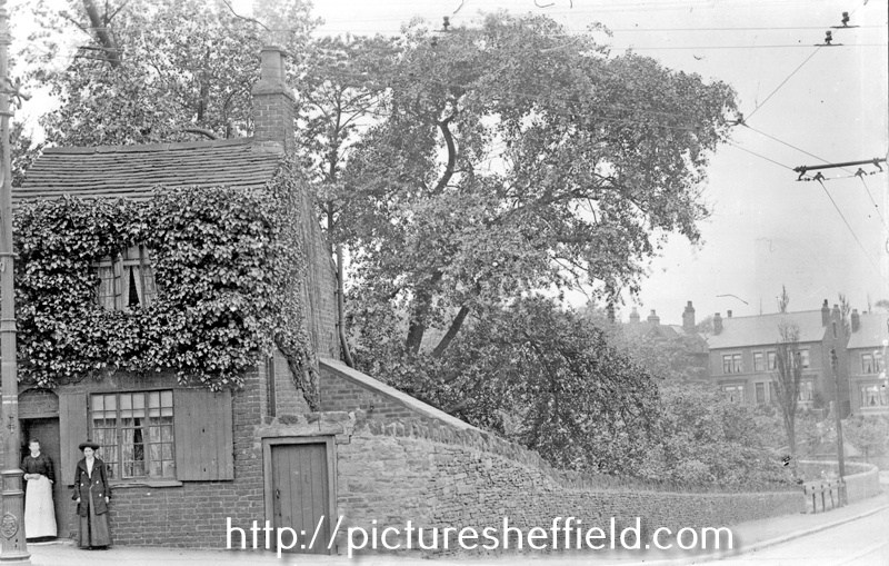
Ivy Cottage/former Catch Bar Cottage, Barnsley Road
Ponytail posted a topic in Sheffield History Chat
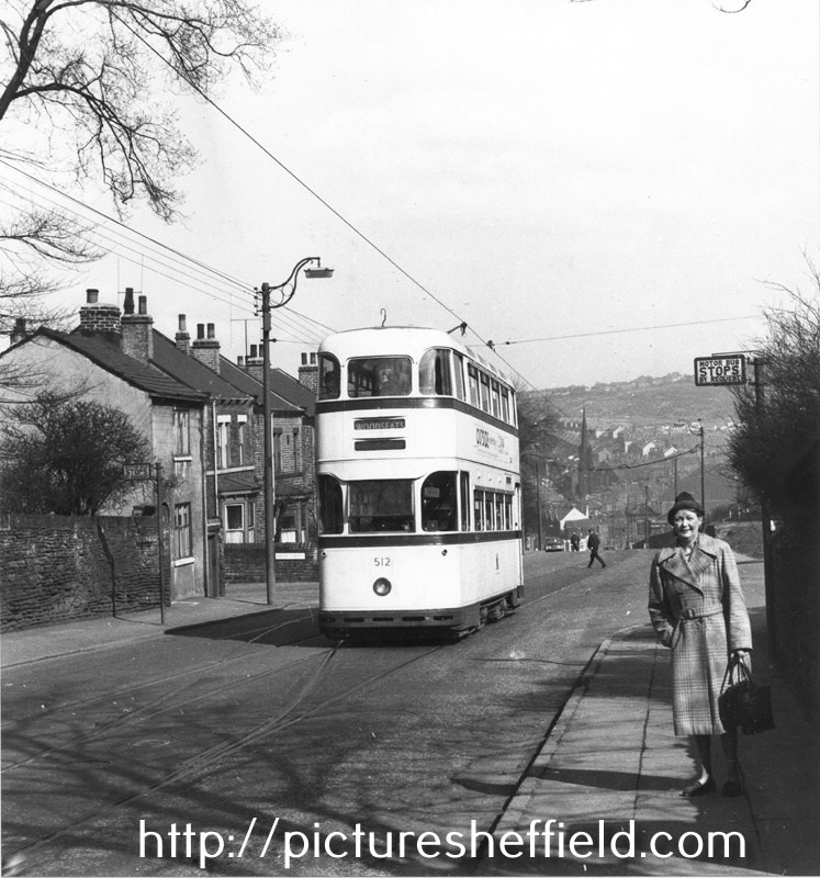
Ivy Cottage, Osgathorpe, corner of Barnsley Road and Batley Street with houses on Crabtree Lane in the background. 1905. s13399 u10512 Photographer: J.E.Vickers Former Pitsmoor Side-Bar or Catch-Bar. Ivy Cottage was built to catch Wayfarers travelling up Barnsley Road, who'd by-passed Pitsmoor Toll Bar by turning up Osgathorpe Road. Hence the phrase Catch-Bar as they 'had' to pay here. Tram No. 512, Barnsley Road looking towards Fir Vale, showing No. 307 Ivy Cottage, former Pitsmoor Side-Bar or Catch-Bar at the from the junction with Batley Street (left) and the junction with Osgathorpe Road (right). April 1960.s25156 Photographer: Mr. D.J. Smithies.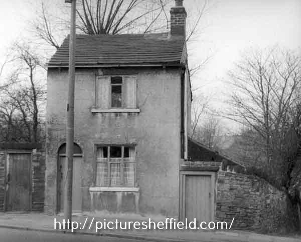
-
Dixon Lane in Sheffield City Centre
Ponytail replied to Sheffield History's topic in Sheffield History Chat
Shame this photograph isn't in colour. Rock Tavern, No. 20 Dixon Lane, 1969. s21769 From: https://www.closedpubs.co.uk The Lost Pubs Project. Rock Tavern. https://www.closedpubs.co.uk/yorkshire/sheffield_s1_rock.html Pub History.com Rock, 20 Dixon Lane. https://pubshistory.com/Yorkshire/SheffieldR/RockDixon.shtml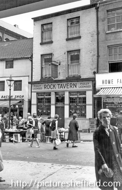
-
Link to: Little Man's Museum /Grapes Inn, Furnace Lane. https://www.sheffieldhistory.co.uk/forums/topic/12408-little-mans-museum-grapes-inn-furnace-ln/
-
SHEFFIELD | Bramall Lane and Shoreham Street in downtown Sheffield
Sheffield History posted a topic in Sheffield Videos
Another fantastic Sheffield Video! Watch video here 👉 SHEFFIELD | Bramall Lane and Shoreham Street in downtown Sheffield -
SHEFFIELD DRIVE | Arundel Gate to Bramall Lane | Sheffield Tour filmed in 4K
Sheffield History posted a topic in Sheffield Videos
Another fantastic Sheffield Video! Watch video here 👉 SHEFFIELD DRIVE | Arundel Gate to Bramall Lane | Sheffield Tour filmed in 4K -
Another fantastic Sheffield Video! Watch video here 👉 I walked through Jew Lane in Sheffield!