Search the Community
Showing results for 'coal pit lane'.
-

Sheffield Water Works Company conduit remains
Edmund replied to Calvin72's topic in Sheffield History Chat
The 1837 Whites Directory tells us that: The New Water Company determined to appropriate the surplus water of the Wyming-Brook. The water intended to be collected there would have to be conveyed through property belonging to a great number of owners, legislative powers were rendered necessary; consequently on 29th May 1830, the royal assent was obtained. HADFIELD RESERVOIR, at Crookes was completed in 1833. This is now the principal service reservoir, being at an elevation of 450 feet above the lower parts of the town, and 200 feet higher than the spire of the Parish Church, so that, from it water can be sent even to the tops of the houses in the highest parts of the town and suburbs. The water is drawn from it by means of sluices, 18 inches square attached to the waste-pit, whence it passes under the bank, and after being gradually contracted to a diameter of 9 inches, is distributed through the street pipes, most of which are cast iron. The waste-pit, in the deepest part of the Hadfield Reservoir, is of a circular form, 8 feet in diameter, and 42 feet deep, and down it the spare water is precipitated into the old reservoirs, which are now used solely for the supply of the lower parts of the northern side of the town. The REDMIRES RESERVOIR and CONDUIT, which supply the Hadfield Reservoir, were commenced at the same time as the latter, and completed in 1836. Bounded on three sides by extensive ranges of hills, the waters from are collected by means of a catch-water drain to one point, where a meter is fixed for the protection of the mill owners on the Riveling, after satisfying which, the surplus passes into the reservoir. Th water is drawn off into the conduit in the same manner as at the Hadfield Reservoir, down to which is a fall of 500 feet. The CONDUIT is about 4 1/2 miles in length, of which 1,200 yards passes under-ground, through a tunnel 3 feet in diameter, and the remainder is an open channel lined with stone, enclosed by a wall on each side, and crossed by numerous stone bridges. In some places where the declivities are abrupt, the conduit is broken into perpendicular falls of from 10 to 14 feet, forming in flood-times, beautiful cascades, and the stream is conveyed over the Tapton Valley through an iron aquaduct, supported by stone piers, at an elevation of more than 30 feet. -
Gardens in the Broad Lane area. Plan of a close adjoining to the Broad Lane with the Gardens etc. formerly part of the said Close, and of another Close contiguous there to as it is now d[ivided] into Gardens the whole being the property of the Duke of Norfolk. 1768. One close entirely, the other partly divided into gardens; these are the closes later to be divided by Garden Street. Tenants names given. Shows 'Burying ground of the people called Quakers'. https://www.picturesheffield.com/frontend.php?keywords=Ref_No_increment;EQUALS;arc02095&pos=685&action=zoom&id=76290 The Close lately held by Thomas Hudson of the Earl of Surrey, divided into lots for gardens. 1782. A close on the south side of Broad Lane (numbered 1 on ACM/MAPS/SheS/1430); gardens listed with measurements. https://www.picturesheffield.com/frontend.php?keywords=Ref_No_increment;EQUALS;arc02094&pos=684&action=zoom&id=76288 A map of a Close belonging to the Duke of Norfolk now subdivided into gardens, and late under Lease with the Golden Cross in Sheffield. 1777. The second close as shown in ACM/MAPS/SheS/1532a, now entirely divided into gardens; numerical list with tenants names, descriptions and measurements; both these closes may be seen also on ACM/MAPS/SheS/1534. Shows 'Burying ground of the people called Quakers'. Shows the proposed route of Garden Street. https://www.picturesheffield.com/frontend.php?keywords=Ref_No_increment;EQUALS;arc02093&pos=683&action=zoom&id=76286
-
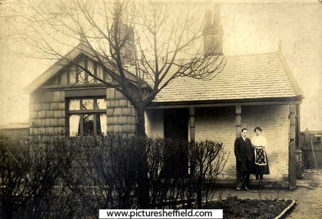
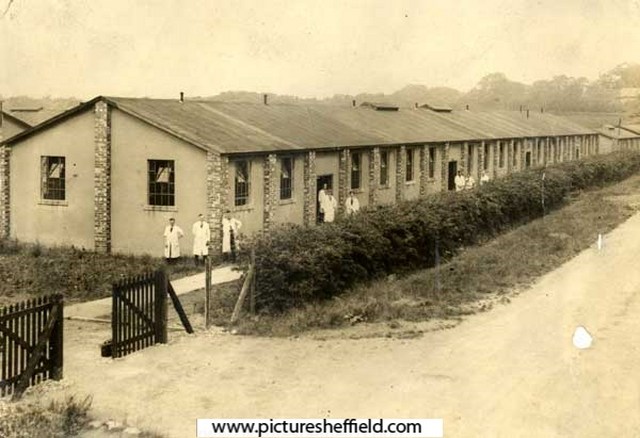
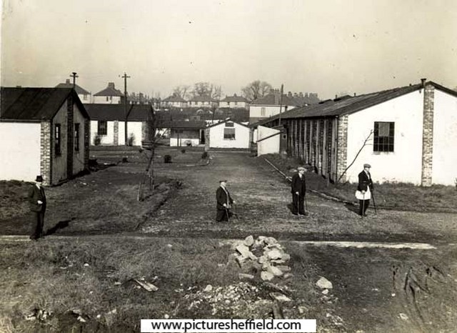
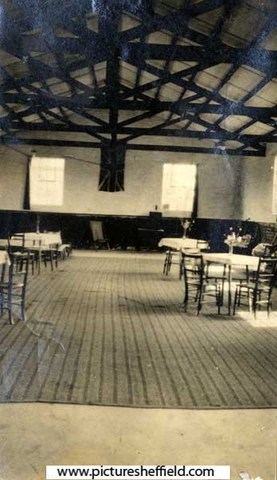
Painted Fabrics - The Haig Homes. arc00616 Painted Fabrics Village - 'Wallwork and his wife outside his house'. Sheffield. arc00615 Painted Fabrics Village, Norton Woodseats. arc00613 Painted Fabrics Village, Sheffield. arc00617 Painted Fabrics Village - new factory in the model village at Coal Aston. arc00614
-

Hatfield House Lane Class J3 1962 Where are you?
Fairthornroader posted a topic in Sheffield History Chat
Retirement brings on many extramural activities and having nearly completed my bucket list before the next bucket I see is the one I kick, I thought it prudent to see who's left out of my old class and where and WHO they are now ( many of the girls will obviously have a change of name ).. See link below http://www.picturesheffield.com/frontend.php?action=printdetails&keywords=Ref_No_increment;EQUALS;m00003 A few of our motley crew, I have sincerely missed since I left and I curiously would like to see how we all did after Smiley's J4 class and the ensuing 11+ dispersal. -
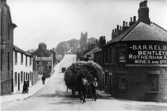
I had a nosey along the current Jew Lane the other day, walked past it loads of times but never along it. Im wondering if it used to be more of a thoroughfare than it is now? Anyone know anything of its history? From other threads there was a Jehu Lane which was where Fitzalan Sq is now, which currently contains all the bookmakers. Im referring to the current Jew Lane that has an entrance on Fitzalan Sq that runs between what is now the Coral bookmakers and the building that used to be the Blue Bel pub, and an entrance on Commercial St.. Heres a view from Commercial St.. From Fitzalan Sq, Looking down Jew Lane from Fitzalan Sq.. Looking back up Jew Lane towards Fitzalan Sq.. Having walked down Jew Lane from Commercial St, here it turns 90 degs right up to Fitzalan Sq. I wonder what this white brick building used to be?..
-
Sheffield Boys Working Home for Destitute Boys, 82 Broomspring Lane
Ponytail replied to Ponytail's topic in Sheffield History Chat
Boys Working Home at 82 Broomspring Lane, 1901 Census. Run by Alfred Stubbing and his wife Sarah. https://www.ourbroomhall.org.uk/content/explore/places/hospitals-and-homes/boys-working-home-82-broomspring-lane-1901-census See also the Comments below the article. "If you Check out the Sheffield Daily Telegraph 7/12/1918 there is an article about some of the former boys that served in WW1 By Nick Beeley (31/10/2017)" " My wife’s grandparents (Windle) also ran this home in the early 1900’s. She has a write up about it and photos of the boys during this period. Copies available to anyone interested. By Tony Biles (09/10/2015)" -
Norfolk Street & Beyond Before we escape back to 19th century Sheffield, I must thank Jane Salt the Stars Archivist for helping with my research, back to when thing seemed more refined. The clue picture on page two shows decorative carvings on what is now the Wicker Herbalist Stores, formerly Hibbert`s Art shop on Norfolk Street. Hibbert Brothers vacated the shop in 1998, the Star covered this event with a brief history of William and James Hibbert, it was claimed, quite wrongly, that the shop had opened in Norfolk Street in 1833, in that year Henry Thomas, a Doctor/ Surgeon, was living and practising from his house at 79 Norfolk street, which wasn’t the original postal number of Hibbert's shop, it was originally 38, it is a fact that William Hibbert was conducting his business at 78 Fargate (now Exchange Gateway) as a carver and gilder and its listed as an artists repository, William lived on the premises, his brother in law George Marples had the same occupation and was going about his business at 31 Church Street and he lived at 59 Bernard Street with his family. John Hibbert, Williams brother was also a carver and gilder plus a picture frame maker, map stretcher and varnisher, John was based on Chester Street, this street has been lost completely, thank you Sheffield council. By 1849 Henry Thomas the Surgeon took on a partner for his practice because of his growing practice, John Taylor Porter changed the practice name to Thomas & Porter, John Porter had been living at 27 Norfolk Street, so it was just a short walk to the practice, I could only speculate on what happened to these two doctors but I suspect they two partners decided to retire, Henry Thomas died in 1882, while his partner John Porter had died just eight years before him, so they must have sold the practice prior to 1852 as by that year Doctor / Surgeon Thomas Chesman who was the senior surgeon at the Public Hospital, Later the Royal Hospital, was holding his surgeries from the practice, sadly Thomas Chesman left this life on the 9th of November 1874, as the years passed the property, had had its postal number changed twice from 115 to what it is today 117, in 1893 William Murfin the London & North Western Railway Co goods manager was living at the property which is now Mammas & Leonie’s Pizza Parlour. So it looks as though Hibbert Brothers moved into the premises round about the late 1890s are now supplying the needs of both professional and amateur artists in the town, so they had only been selling their wares from Norfolk Street for just over a hundred years not 164 as claimed but that’s irrelevant as its still an important part of Sheffield’s history. By 1905 William Hibbert was living at 96 Broomspring Lane and John lived at 9 Westbourne Road the other brother Samuel George was residing at 42 Brocco Bank. This area of the town was always busy especially when the Surrey Street Music Hall was open, this grand theatre was built in 1823, it was more than just a Music Hall as its largest room accommodated 1,000 people quite easily, this theatre was just one of many in the town, the Gaiety, the Britannia, the Grand, the Phoenix, the Theatre Royal and of course Tommy Youdan’s which was the Alexandre Theatre on Blonk Street, I cant name them all but it was a cut throat business and nobody made a fortune out of them, if one owner or manager was breaking the rules, a rival sent in a spy to report back which in turn an official complaint was made against them via the watch committee. The Surrey was regarded as one of the best, if not the best, the world famous violinist Paganini performed here to a rapturous audience as did Jenny Lind, the Swedish Nightingale, one celebrity who was small in stature but a giant on stage was General Tom Thumb who gained stardom through P. T. Barnum. Mr Charles Dickens, England’s greatest author, appeared here several times, in 1852 acting as manager and actor he performed along with Mr Wilkie Collins, in a play entitled “Not So Bad As We Seem”, the admission costs for performances like these really kept the general populace out of the theatre, ten shillings and sixpence and seven and sixpence were way above what a working man could afford, in 1873 it was decided it was too small and it was still used as a theatre, into the early twentieth century it was used by J.G. Graves the original mail order company, he gifted the people of Sheffield Graves Park and not the council it was ours. One job that was fiercely argued over with many fights breaking out on theatre nights, it was the lucrative road crossings that the ladies of the town had to cross in all their finery, what was the job you may well ask? It was the sweeping horse droppings from off the crossings, you can imagine the amount of horses in the town at that time and you cannot train horses just where to drop their apples, so any lady wanting to cross was approached by the sweepers and swept a clean path across the road for which he received a penny or tuppence. The Surrey Theatre stood in the exact spot where the Central Library now stands. In 1841 this house was the home of William Hibbert Picture Framer & Gilder, 96, Broomspring Lane
-
Old Plans (40's/60's) to relocated West Street via Broomspring Lane
Sheff-lad posted a topic in Sheffield History Chat
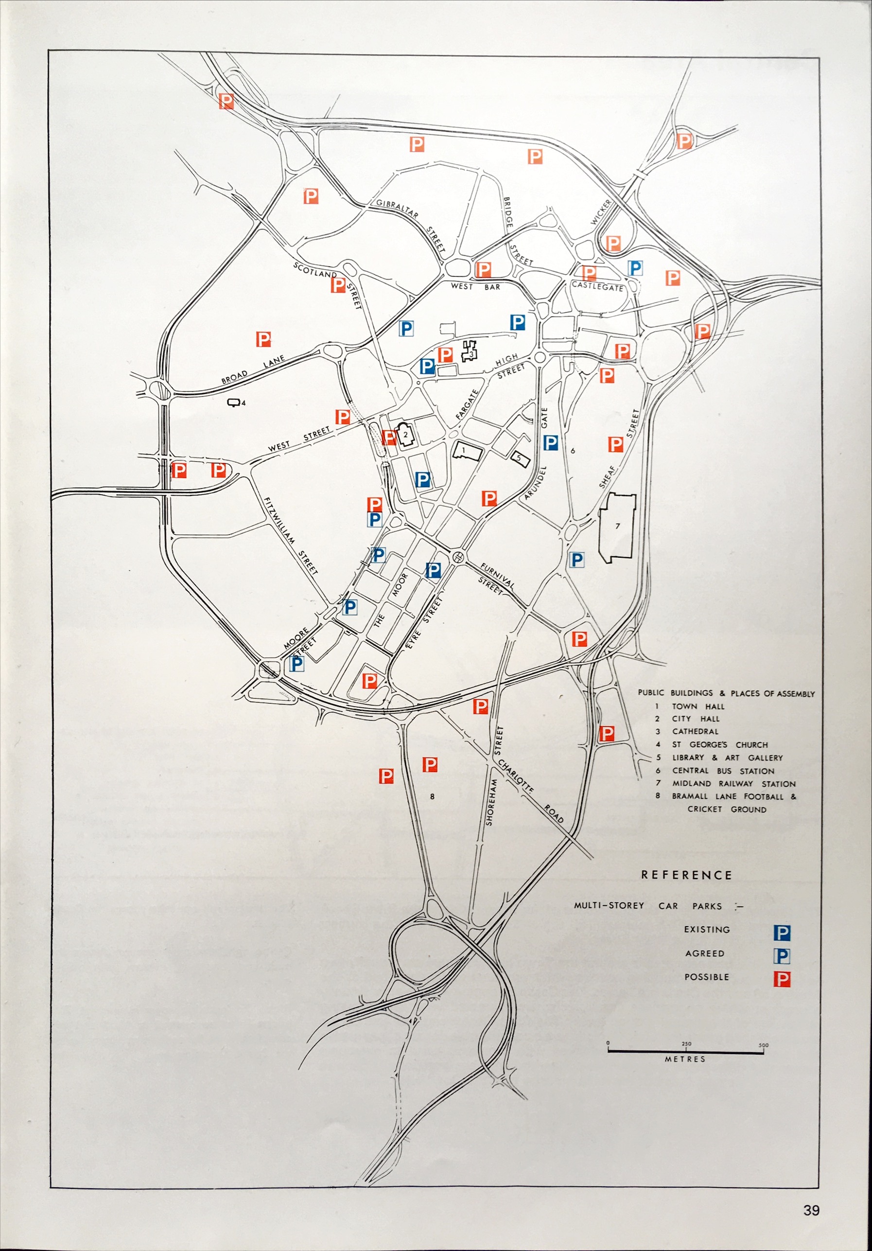
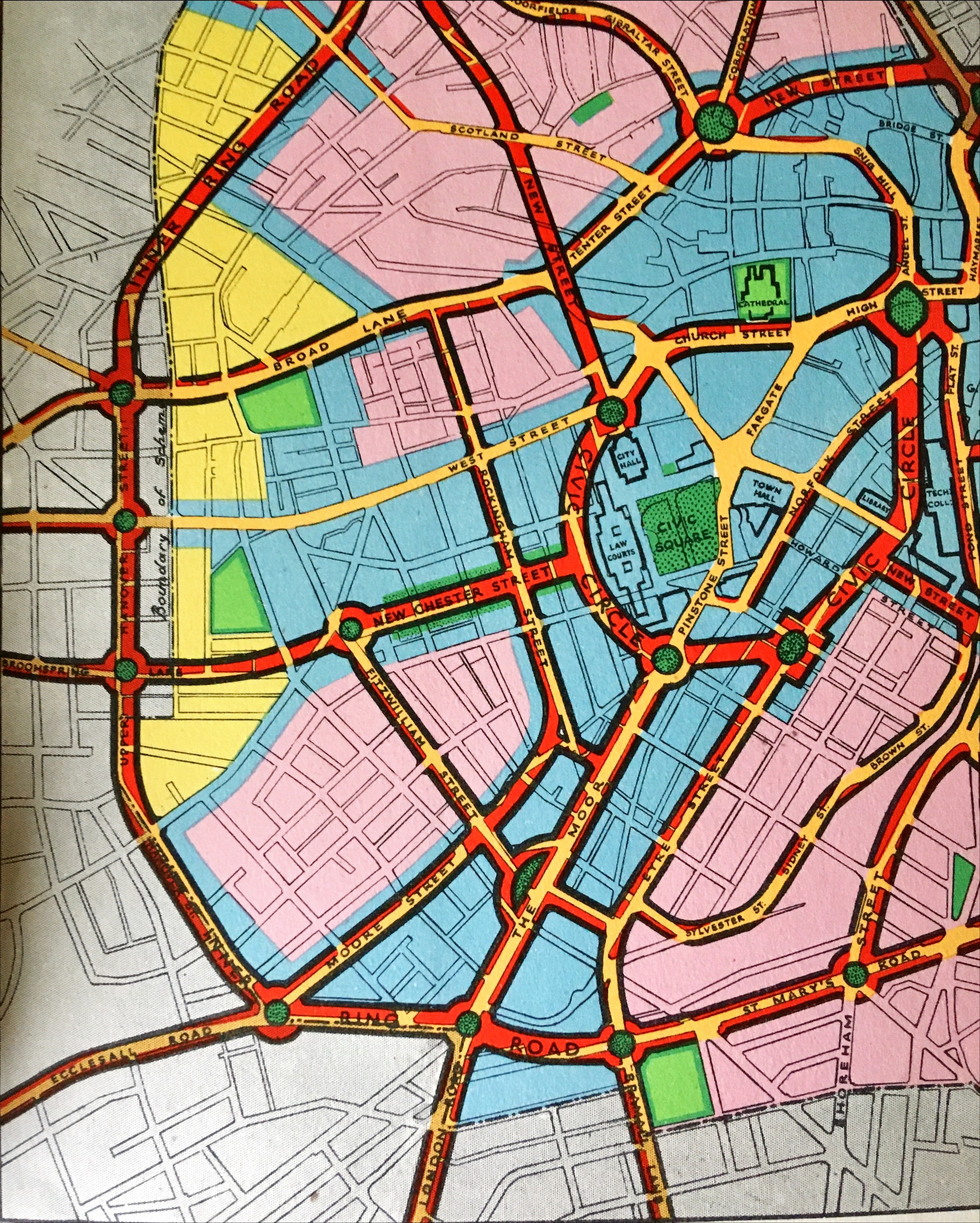
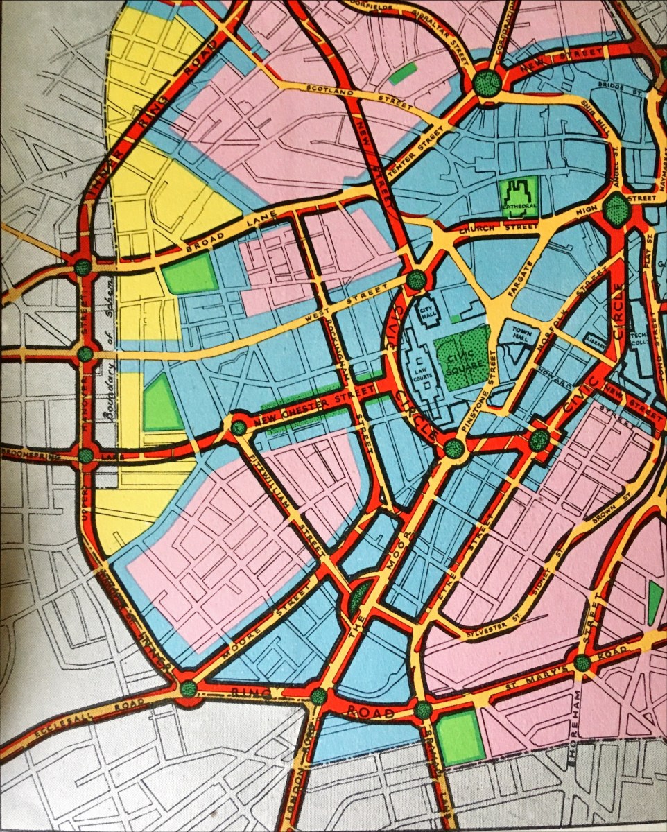
I recently bought 'Sheffield: Emerging City (1969)' on how post-war rebuilding was going and what they planned to do for the future, which other than being a brilliant book, revealed old plans as they were in mid-flow. I was reading it and found in their overall plans that there was a side-plan to relocate West Street at the junction with Fitzwilliam Street via Broomspring lane, creating a new junction on the ring road where Hanover Street becomes Upper Hanover street. I wondered if anyone knew anything more about where this road would go or if anyone had any more details of the plan or whether it was just a brief side-note on the diagram. It also shows that (as originally planned in 'Sheffield Replanned (1945)') there would be another street or entrance way to the city along Wellingon Street which again is nowhere to be found. Photos attached, any information would be greatly appreciated. - I wonder if it would join Glossop road near the Hallamshire and be a dual carriageway along Manchester Road. The overall plan in two parts for the A61(M.) The area in question With the routes highlighted The diagram from 'Sheffield: Emerging City (1969)' The new street along Wellington Street as seen in 'Sheffield Replanned (1945)' And again from another angle And here as part of the overall development map.thumb.jpg.febacffcdb3cb364d1f05d792679250c.jpg)
-Copy.jpg.47e31c3ac3e801a8cc54d4666f9b98cf.jpg)
-RoutesShown.thumb.jpg.5370a934b8866808f38b11c5175942ca.jpg)
-
Booth & Co., Park Iron Works, Brightside Forge & Royds Mill.
Ponytail replied to Ponytail's topic in Made In Sheffield
Plan of Salmon Pastures held of the Duke of Norfolk by Thos. Sambourne. 1792. Surveyor: William Fairbank II. https://www.picturesheffield.com/frontend.php?keywords=Ref_No_increment;EQUALS;arc02669&pos=7&action=zoom&id=91474 Shows part of the River Don, and the Goight and Foundry; (Warren Street, Royds Mill and Farm.) fields etc. lettered and listed with particulars: a. Proposed to be taken on lease for 99 years. b. Proposed to be given up to the Road. c. Lower Salmon Pastures, as proposed to be altered. d. Held by Booth & Co., part of the Netherfield. e. Island. f. Upper Salmon Pastures. g. Lower part. h. Upper part, proposed to be kept for sand. Held by John Booth & Co. A map of Salmon Pastures held of the Duke of Norfolk by Wm. and Geo. Binks.1787. Surveyor: William Fairbank II. https://www.picturesheffield.com/frontend.php?keywords=Ref_No_increment;EQUALS;arc02667&pos=5&action=zoom&id=91471 Between (Warren Street) and the goight and the Don; closes, etc., numbered and listed with particulars. Includes the Nether Field and the old wheel; numerical list with acreages; field names given on the map. (Royds Mill and Farm.) It's probable that Burton took over the Mill before 1720. 1718/19, Burton Dam appears in the Repair account. 1737 William Burton took a 21 year lease of "corn mill called Attercliffe Mill near Washford Bridge" 1756 lease still in the name of Burton, 1761 the property listed in his will. 1765, Hartop, ironmasters had a 21year lease; 1782, Binks, Booth and Hartop, the lease recording the poor condition of Royds Mill and Wheel and measures needed by the new tenants to rebuild it and improve the water supply. 1794, Booth & Co. recorded at Royds Mill & Wheel. The partnership were at this time on the south side of the River Don, developing the Park Ironworks. 1821, Royds Works advertised for sale or let by Auction described as a Corn Mill; Forge and Rolling Mill. A Map of the Turnpike Road from Westforde [Washford] Bridge to the Mill Goite, c.1760-1770. Surveyor: John Needham. https://www.picturesheffield.com/frontend.php?keywords=Ref_No_increment;EQUALS;arc02665&pos=4&action=zoom&id=91373 Outline of the mill wheel and goit; 'measurement of land required to make the road straight.' (Royd's Mill Street) Marked: Mr. Burton Lane. River Dun (Don); Weste Ford Bridge (Washford) (Royds Mill and Farm. Windsor Street.) For more information about Royds Mill and Wheel, see "Water Power on the Sheffield Rivers" , edited by David Crossley with Jean Cass, Neville Flavell & Colin Turner. -
History of Attercliffe and the Benjamin Huntsman steelworks
Ponytail replied to a topic in Sheffield History Chat
A Plan of two Closes, Buildings, etc. held under the Duke of Norfolk by Samuel Scholey and W. Scrapper. 1763. https://www.picturesheffield.com/frontend.php?keywords=Ref_No_increment;EQUALS;arc02680&pos=75&action=zoom&id=91520 Surveyor: William Fairbank II. This is one of the enclosed strips south-west of Worksop Road; acreages listed; explanation of the buildings. Marked: Close in Saml Scholey's possesion. Close in W. Rapper's possesion. Included in the next strip: B. Huntsman's Furnace; a. Part of Benjamin Huntsman's Yard; b. A shed erected by him; c. Part of a Mill House built by him; d. A piece of Ground proposed to be taken by him for enlarging his Works; e. g. Buildings; f. a Yard; h. h. i. Gardens, held by William Crapper. k. Another part proposed to be taken by Benjamin Huntsman for enlarging his works. the etc. in the next strip. Also marked: Lands vested in the Capitol Burgesses of Sheffied; Attercliffe Green; (Attercliffe Steel Furnace, Worksop Road, Shirland Lane.) -
Originating in those parts I am always amazed at the loss of so many old properties….I suspect with the provision of Council housing in the main. In my time living at the Lane Top we have lost cottages on Elm Lane as well as old housing on Hatfield House Lane! As a matter of interest ,is Hatfield House itself still in existence?
-
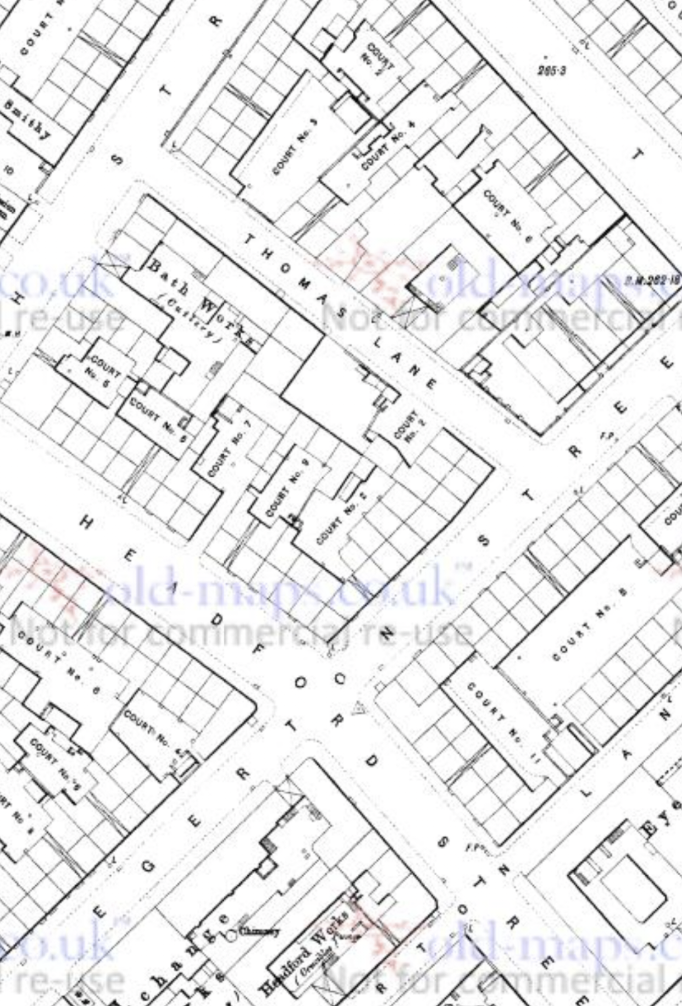
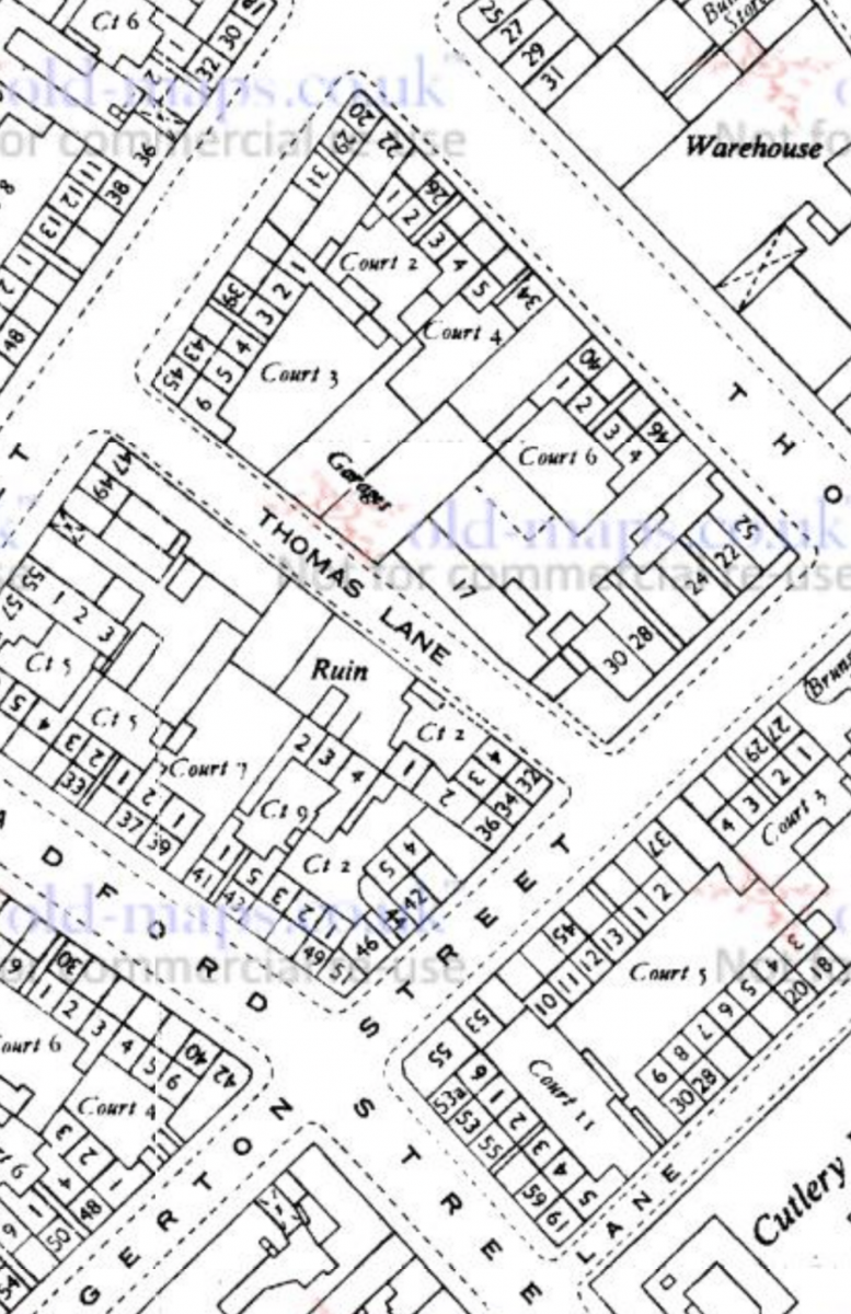
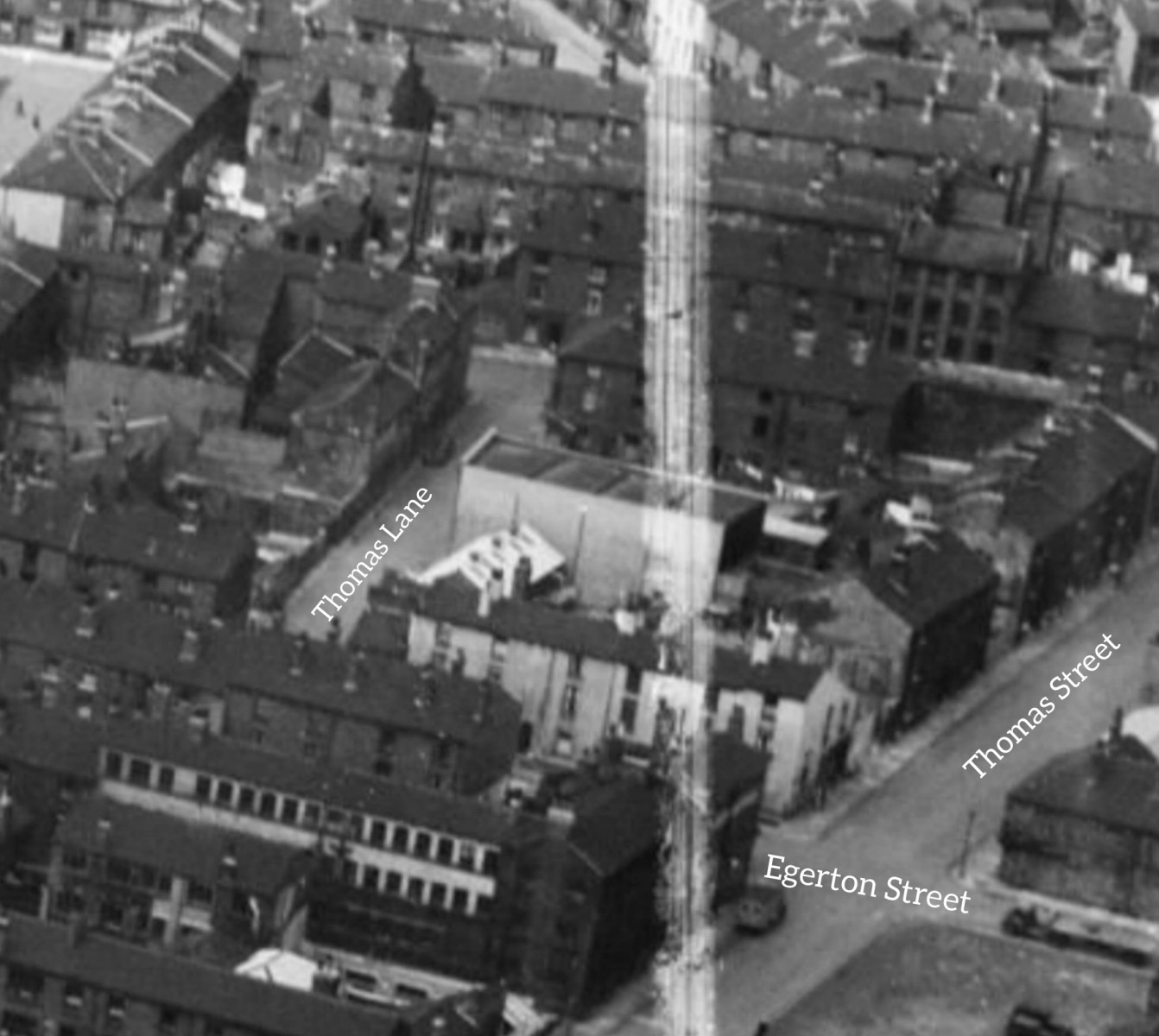
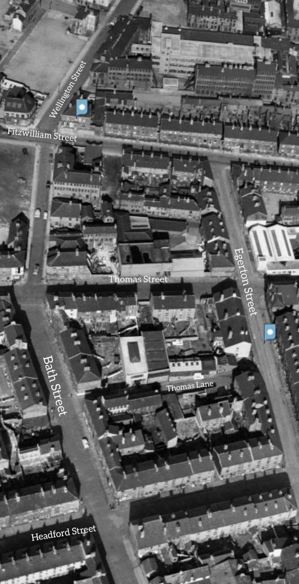
Afternoon all! I'm not sure if this is the right place for a request, but here goes. My Grandad's family lived on Thomas Street for a number of decades, stretching from around 1895 to the 1930s, but afterwards they relocated to Thomas Lane, which was a little Street between Bath Street and Egerton Street, Broomhall. Anyway, it turns out that they were living at number 5, as confirmed by both the 1939 Register, family documents, and a rather interesting newspaper article from that year. I've had a bit of trouble pinpointing the location of number 5 Thomas Lane, as there are no references to it being in a court, and no specific photographs of the street exist (I've included two from Britain from Above.) Even the 1905 Goad fire insurance maps cut off right before the street is covered! I was wondering if anyone on here knew any more about the area, or where the house might have been? Thanks, Lewis Waddingham

-
A plan of sundry Tenements in Jehu Lane with the Carriage Road proposed to be made for their accommodation through the Ground held of the Earl of Surrey by Robert Lambert. 1783 Surveyor: William Fairbank II. Tenements bounded by Jehu Lane, Baker's Hill and Shude Hill. Tenants; measurements given of the area concerned in the making of the new lane (unnamed). (Fitzalan Square) https://www.picturesheffield.com/frontend.php?keywords=Ref_No_increment;EQUALS;arc03167&pos=9&action=zoom&id=98189
-
Map showing Jehu Lane. Plan of Baker's Hill and Shude Hill shewing a proposed improvement there with a section of Baker's Hill and part of Shude Hill. 1840 J. Fairbank and Son. Shows Fruit Market, Hay Market, Market Street, Jehu Lane, Bakers Hill, Norfolk Street, Flat Street, Pond Street, Forge Lane and Shude Hill. https://www.picturesheffield.com/frontend.php?keywords=Ref_No_increment;EQUALS;arc04038&pos=4&action=zoom&id=103298
-
Map shows how the planned new street sweeps away the properties on Jehu Lane. Plan of proposed new street [Flat Street] between Old Haymarket and Pond Street. 1845 Also shown are Wain Gate, Town Hall, Castle Street, Castle Folds, Tontine Inn, Dixon Lane, King Street, Shambles, Fruit Market, Market Street, Jehu Lane, Norfolk Street, Bakers Hill, Shude Hill, Little Pond Street, Sycamore Street, and Pond Hill. From a volume of plans of new streets and street improvements, made by Flockton, Lee and Flockton, 1845. https://www.picturesheffield.com/frontend.php?keywords=Ref_No_increment;EQUALS;arc06813&pos=5&action=zoom&id=106244
-
From the album: Chapeltown
-

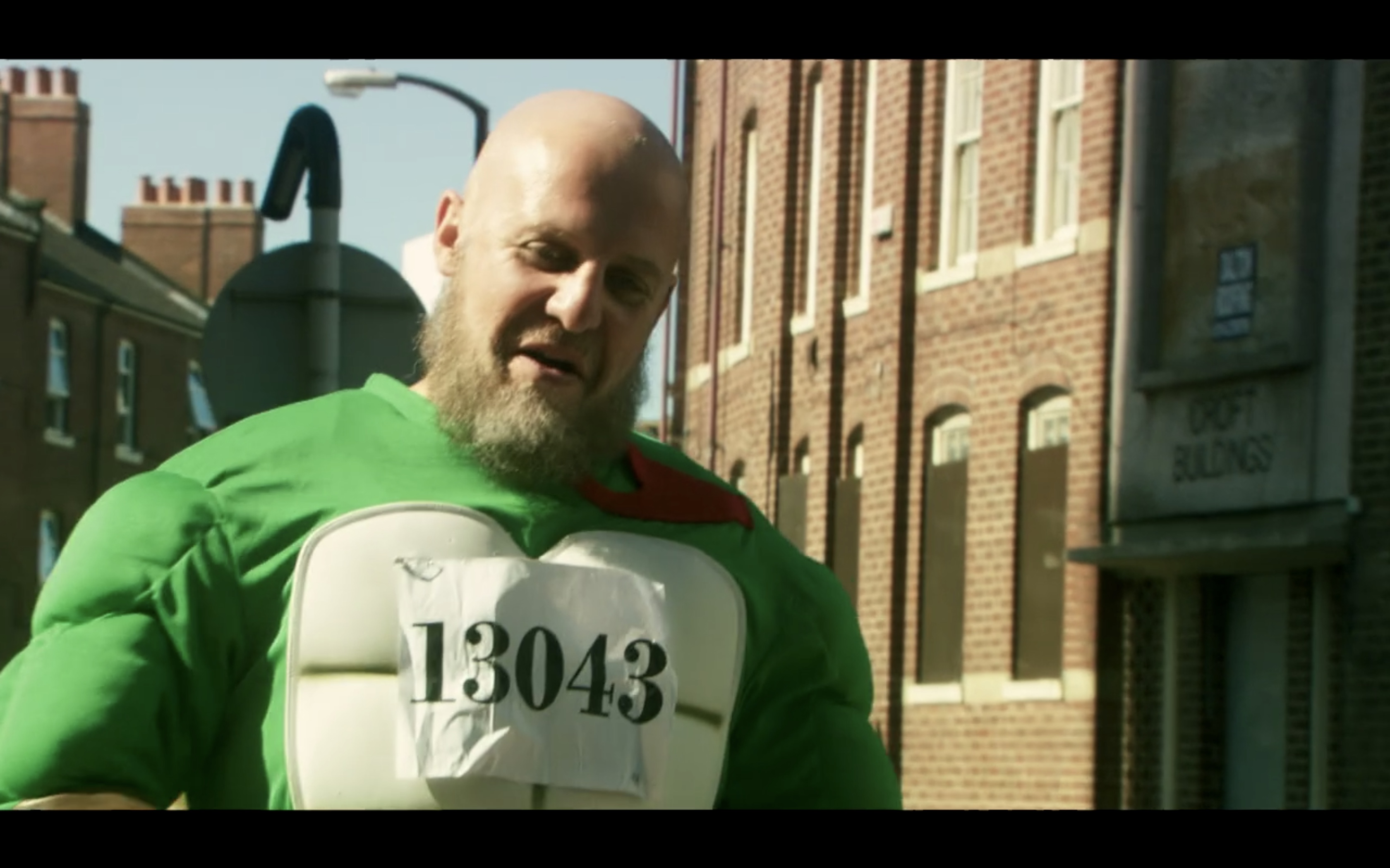
Barry confronts Omar outside Urban Deli on Campo Lane - Four Lions Filming Location
Sheffield History posted a topic in Four Lions Filming Locations
FOUR LIONS FILMING LOCATION - CAMPO LANE This scene is another cracker as Barry finds Omar in Urban Deli on Campo Lane Barry decides to eat his sim card but ends up choking on it with explosive results!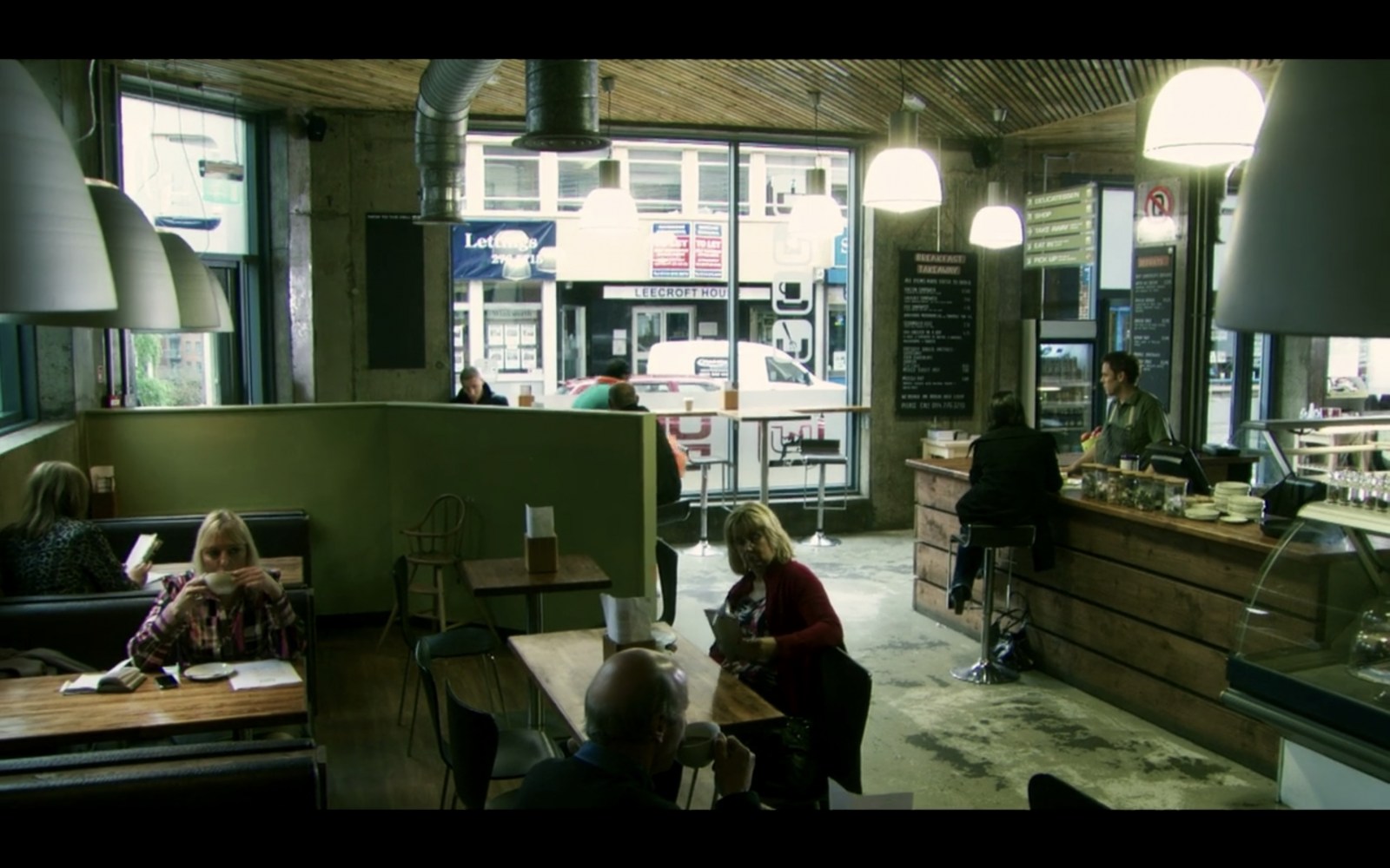


-

Newhall Road, Newhall Wire Mills
SteveHB replied to Aaron James Hartley's topic in Sheffield History Chat
The illustrated guide to Sheffield and the surrounding district. 1879. "Messrs. John Hartley and Co., Newhall Wire Mills, manufac- ture wire for pit and other ropes, umbrellas, and various other pur- poses. On the next page we give an illustration of their works, which have been carefully arranged with a view to the requirements of the business, and are fitted with modern machinery and appliances." link https://archive.org/details/illustratedguide00tayl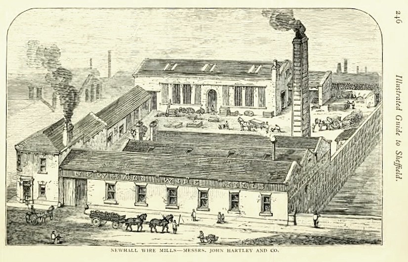
-
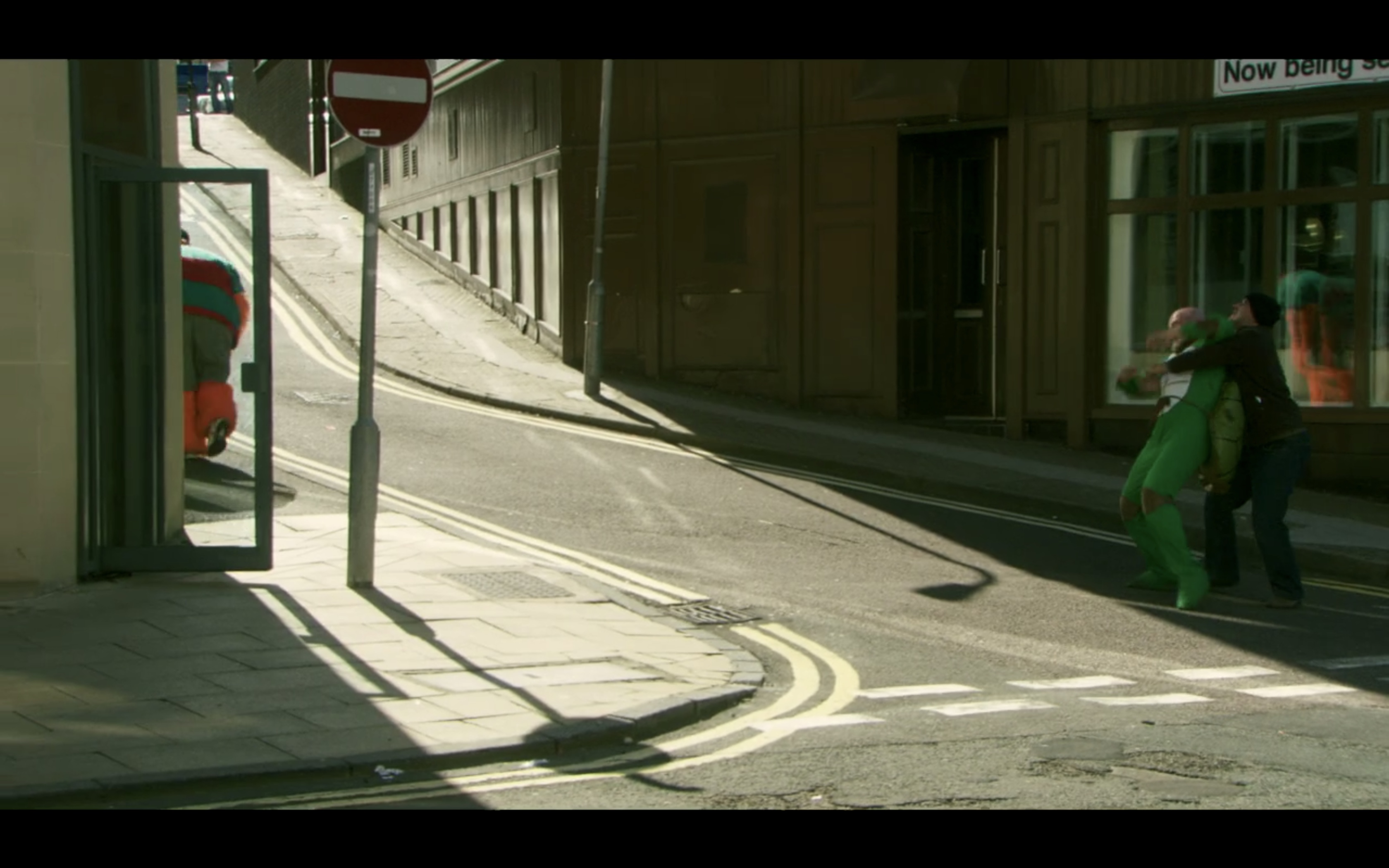
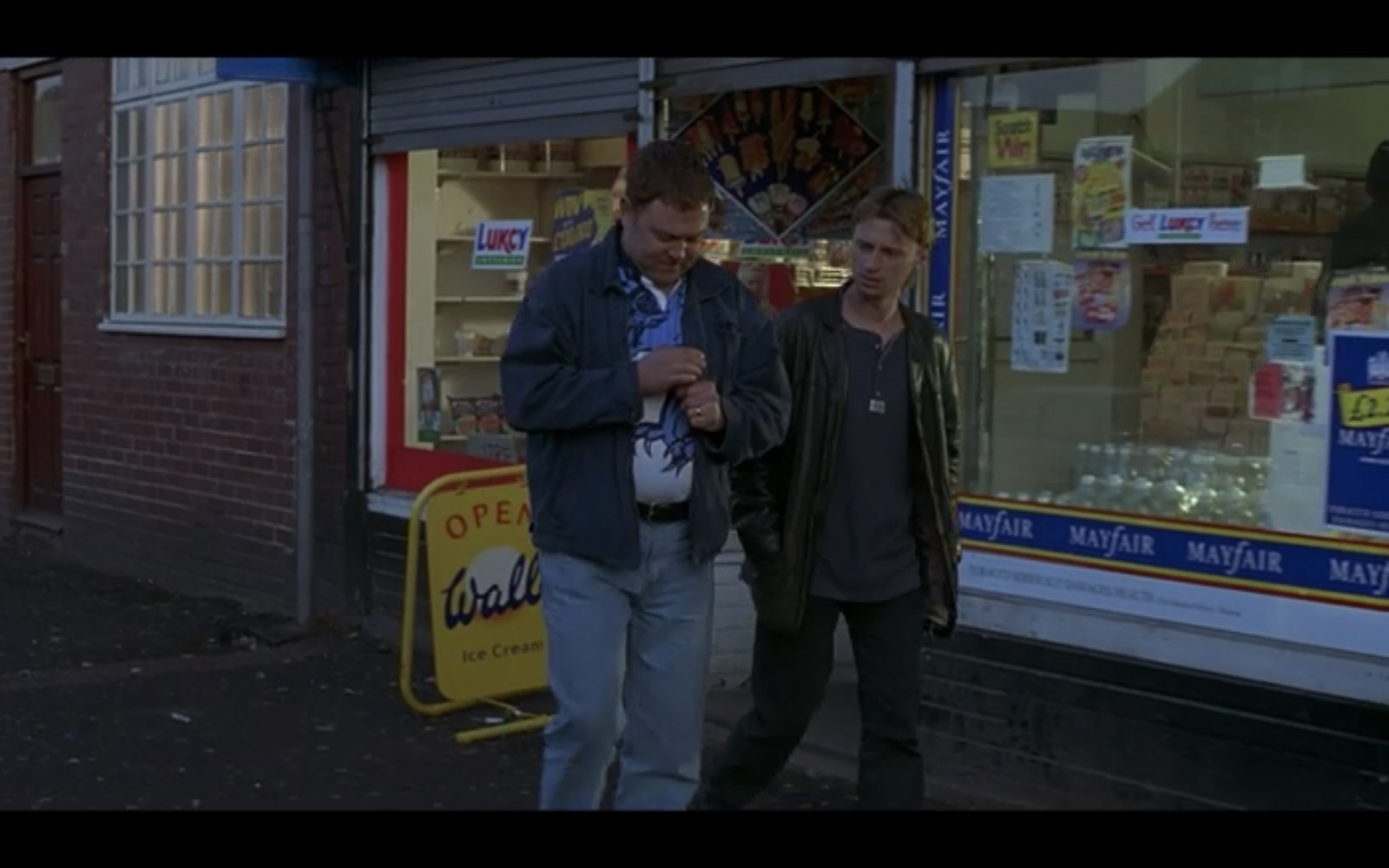
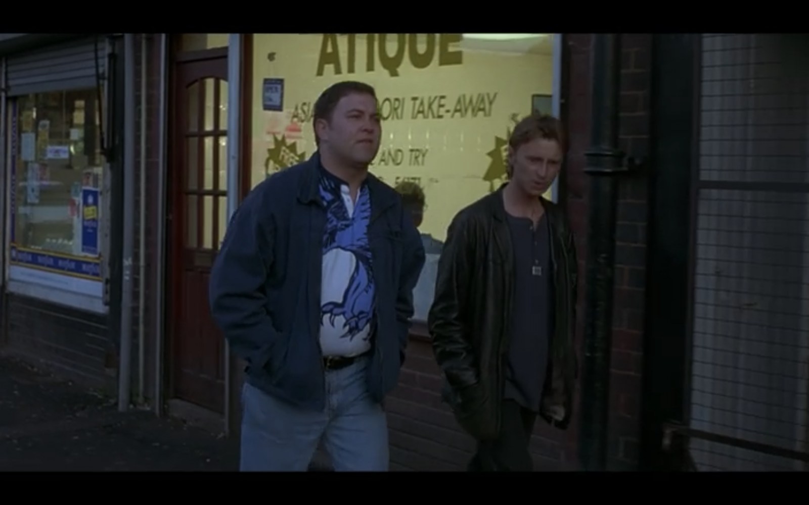
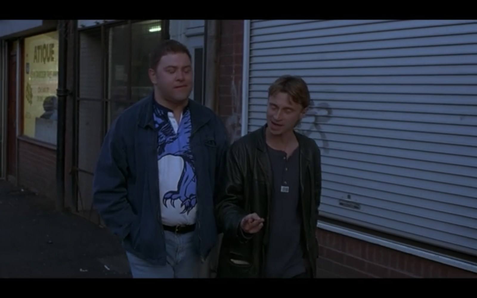
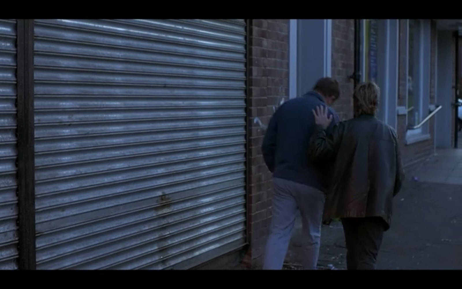
Stubbin Lane Sheffield - The Full Monty Filming Location
Sheffield History posted a topic in The Full Monty Filming Locations
The Full Monty Filming Location at Stubbin Lane, Sheffield Here we see Dave (played by Mark Addy) and Gaz (played by Robert Carlyle) walking along a row of shops chatting. The actual filming location is Stubbin Lane in Sheffield See below...
-
Sheffield Water Works Company conduit remains
Ponytail replied to Calvin72's topic in Sheffield History Chat
Plan of an Estate near Fulwood. 1868. Architects: Fowler and Son, Sheffield. Pawson and Brailsford, Lithographers, Sheffield. https://www.picturesheffield.com/frontend.php?keywords=Ref_No_increment;EQUALS;y11281&pos=49&action=zoom&id=104296 Shows Brown Hills Lane; also Sheffield Water Works conduit from Redmires to Sheffield. (at the top of the map) Owners / tenants: John Sheldon, esquire, Joseph Green and Sprotley School, Stephen Fox, Samuel Shore, esq., John Broomhead, The Duke of Norfolk, and William Waterfall, esq. Original at Sheffield Local Studies Library: Sale Plans 4 August 1868. -
Plan of several Estates the property of [William - changed to James] Boothby situate at West Grove near Sheffield, 1828. https://www.picturesheffield.com/frontend.php?keywords=Ref_No_increment;EQUALS;arc04200&pos=12&action=zoom&id=105084 Marked: Birley's Charity Land, Turnpike Road from Barnsley to Sheffield [Pitsmoor Road], Harvest Lane, proposed streets; land [belonging to George Bustard Greaves Esquire, Mr Duke’s property, Jonathan Marshall, Esquire; Mr Harmer, Thomas Naylor, Pie Bank [Pye Bank], pleasure ground, farm yard, Middle Field Garden, Far Field, gardens occupied by Mr Needham, Lingard, Hewitt, Rawson, Richardson and Wostenhome, Robinson, Kent, Bingley, Twigg, and Kitchen.
-
Unidentified Public Houses and Refreshment Rooms
Edmund replied to Ponytail's topic in Sheffield History Chat
Welcome Samuel Gillatt, son of George (scissor forger) and Caroline, was born on 27th August 1867. His main career was as a file cutter, but he may have started catching rats to be worried by dogs. By 1901 Welcome and his wife Ada were at 165 Woodside Lane with 5 children, one of whom was Welcome junior aged 4. His first newspaper advert appears to be in the Mexborough & Swinton Times of 3rd December 1897: WELCOME GILLAT. Ratcatcher, open for engagements. Dealer in Ferrets. Ferrets lent on hire, ratting or rabitting. :- 25 Court, 2 house, Woodside Lane, Sheffield. In December 1901 as well as his ratcatching services, he advertised "Ship rats for sale" - an unusual Christmas present, or for worrying by dogs? In February 1919 Welcome was appointed "Official Ratcatcher to the City". This was the first time such an officer had been needed, but was due to the plague of rats which had grown during the war, mainly due to the increase in land under cultivation. Then as the winter weather arrived, they migrated to built up areas. Welcome had been catching rats for forty years, catching them alive with ferrets and a wire cage. Applications for his services had to be made through the Cleansing Department Superintendent. In March he caught 1,050 rats in four weeks, beating all previous records. Yorkshire County Council were granting 2d per rat killed to Sheffield City Council. In October 1919, Welcome had a great success in catching a wily old rat that frequented the Cathedral neighbourhood. This rat was fancied to be 'a grand old man' with a long grey beard and a splendid voice despite his years. Supposedly the rat danced on the Cathedral tombstones, and was a politician, addressing mass meetings of his tribe in Paradise Square each night. Welcome set out to 'bag him' and after a successful and exciting hunt declared "Yes, he's a beauty - he weighs just over a pound and will be one of the biggest we have in England". Welcome was so successful in his work that a bag of 40 rats a day was now considered a good one. In the "good old days" a bag of 375 in a day was possible. In August 1922 Welcome caught an outstanding specimen weighing 1 lb 5 oz at Mr Simmerson's house, 100 Nottingham Street. Mr Gillatt had netted the entrance to several holes when the rat was discovered in a fowlhouse. It jumped one of the nets and as it was making its escape Welcome grabbed it and captured it alive. He took it to the Telegraph offices to show it off, whereupon it attempted to snap at its captor. Welcome intended to have it stuffed, as "the finest specimen I have ever captured". He estimated that over his career he had killed tens of thousands in Sheffield alone, plus those in outlying districts. In 1927 he tamed and trained a fox, with the intention of using it to catch rats. In 1939, still the Corporation rat-catcher, he was living with Ada at Firshill Terrace. Welcome died in 1940. Welcome junior joined the Royal Navy in June 1915 as an armourer and was discharged in November 1921. He married Elsie McKay, also of Woodside Lane, in November 1919 and they had two girls, Edna and Joyce. Welcome junior died, a 33 year old bus conductor, at Lodge Moor Hospital in February 1930. Welcome senior's son Ernest, a fireman, married Frances Brayshaw in September 1927 and they named their son (born early in 1931) as Welcome. Welcome died in Sheffield in Oct/Nov/Dec 1996, and his wife Lilian Anita in 2018. Presumably this chap was the licensee on the photo of the unidentified licensed premises. -
I wonder if anyone remembers the above? We called it the "drink shop" and it was run by "Aunt" Gladys and her sister. This tiny shop, with a bench seat along one wall,was where we bought our 2 oz of rationed sweets, our ice cream cornets, pop and ,when available, a glass of sarsparilla. Aunt Gladys was a lovely woman who, having one of the first TV sets in Firth Park, would occasionally invite a few of us regular kids into her back room to watch BBC Childrens TV and have ,as a treat, one of her home made ice lolly's.
-
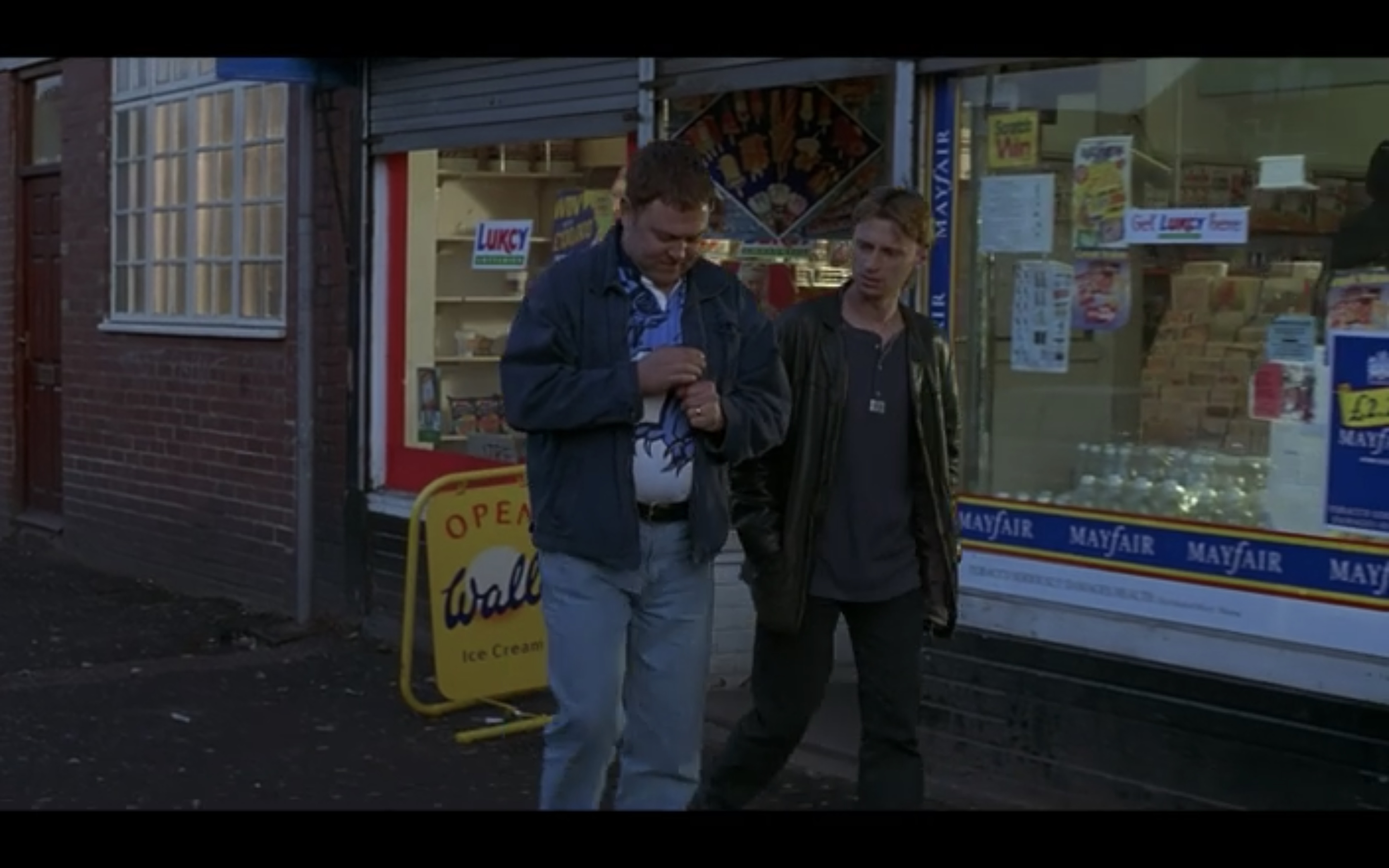
Shirland Lane Sheffield - The Full Monty Filming Location
Sheffield History posted a topic in The Full Monty Filming Locations
This shot of our characters walking up a hill was incredibly difficult to pin down but I did it (eventually!) This shot was achieved by the cameraman being quite a way away from the actors but zoomed right in on them, and the 'hill' wasn't actually a hill they're walking up but was the hump of a bridge between the cameraman and the actors! This actual Full Monty Filming Location is Shirland Lane which is in the Attercliffe/Darnall area of Sheffield The pub seen to the left is no longer a pub See below for the actual Sheffield location and what it's like now!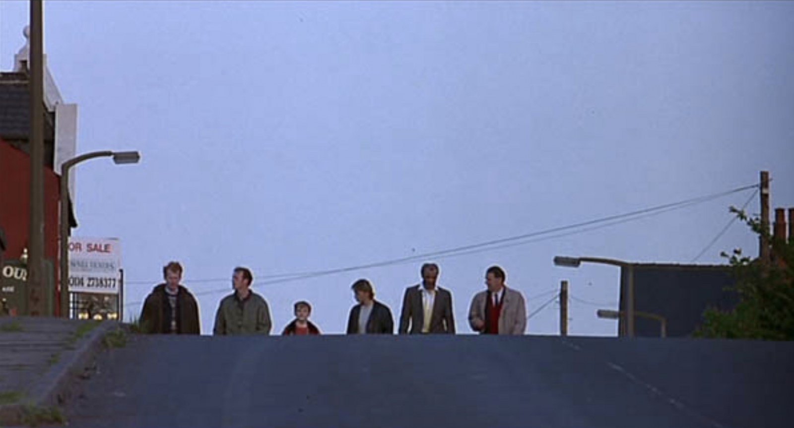
-
Yorkshire mining and the Tavistock Institute
Viners replied to Roger Arevalo's topic in Sheffield History Chat
Is Elsecar Colliery near Barnsley a good candidate? I see that the same coal seam (Haigh Moor) would have been mined from multiple pits, which makes it harder to pin down the actual location. It sounds like the research on sociotechnical systems was done at a mine that Ken Bamforth had worked in before becoming more of an academic. If you can establish that he worked at Elsecar, that might help to confirm it. 1 Source: https://breadtagsagas.wordpress.com/tag/elsecar-collieries/ "These areas of concentration were the discovery and analysis of industrial democracy underground in the Elsecar Collieries by Trist and Bamforth. The development of the theory of sociotechnical systems based on this and on insights from psychology and the social sciences." Tavistock Institute gets a mention. 2 Source: https://en.wikipedia.org/wiki/Eric_Trist "Organizational research In 1949, his organizational research work, studying work crews in at Elsecar Collieries, with Ken Bamforth, resulted in the famous article, "Some Social and Psychological Consequences of the Longwall Method of Coal Getting." This article highlighted aspects of the miners organisation that today would be termed lean or agile." 3 Source: https://en.wikipedia.org/wiki/Elsecar_Collieries "Elsecar Main Coal extraction proper began at Elsecar Main between 1905 and 1908 when shafts were sunk to the Parkgate seam at 333 metres. Other seams worked were the Silkstone, Thorncliffe and the Swallow Wood seams. The Haigh Moor, Lidgett and towards the end of the colliery's life, Kents Thick seams were also mined. The colliery closed in October 1983." This all fits roughly with the location of South Yorkshire and the mine where the work practices were found being "a recently opened seam" as at 1950/51. Trist and Bamforth were probably researching multiple things and might have visited lots of different mines, so references and quotes might have become a bit muddled. I saw a couple of mentions of other locations, but they don't fit as good as Elsecar does.

.jpg.a0662ce0cd9ba0025e89c626f9f01cac.jpg)
-RoutesShown.jpg.522e7a4bf8813eb4734a43122ea88980.jpg)