Search the Community
Showing results for 'coal pit lane'.
-
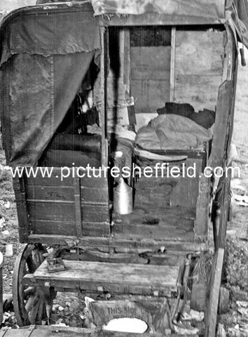
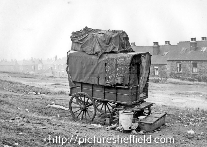
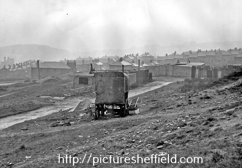
Ex-Railway type van in a deplorable condition, placed on waste land and housing a man and wife and their child aged 1 year and 9 months, and another adult female, both females were pregnant. 31st August 1950. u01685 Photograph shows an ex-railway type van placed on waste land in June 1950. The van measured 8' 9 long, 5' 0 wide and was 5'7 high. The van was in a poor condition and there was no sanitary accommodation or water supply, lighting was by candles and there was a coal fired, metal stove inside the van. The van was generally in a deplorable condition, and the site around was littered with refuse. The occupants were a man and wife and their child aged 1 year and 9 months, and another adult female. Both adult females were expectant and both had other children, either with foster parents or in childrens homes. The occupants were eventually found accommodation by the Social Care Department. u01684 u01686
-
Hi, Have just joined this group. I am looking where I can find photographs of Water Lane, Sheffield. Around the period 1870-1890. Any assistance would be most welcome.
-
Hi Martin, Watts patent monopoly was extended by Act of Parliament up to 1800, so no doubt there would be a cost implication. Newcomen's engine continued to be installed at collieries in large numbers during the period of Watt's patent. The Newcomen engine was much simpler and cheaper than Watts' engine, and Watt's advantage of economy of fuel was irrelevant when operating at a coal mine, as opposed to say tin mines (Watts machinery did well in Cornwall). I think that long ropes tended to be produced for nautical applications (as your Chatham example). Even where deep pits operated (such as in the North East), their lifts were in sections, and most other colliery depths were much less than the average UK sea depths. An anchor rope for a ship would have unknown and variable depths to contend with, whereas the requirement in a colliery was known and fixed.
-
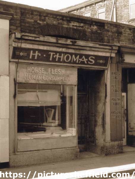
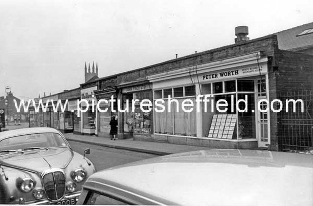
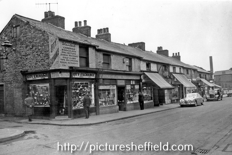
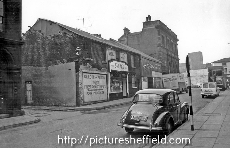
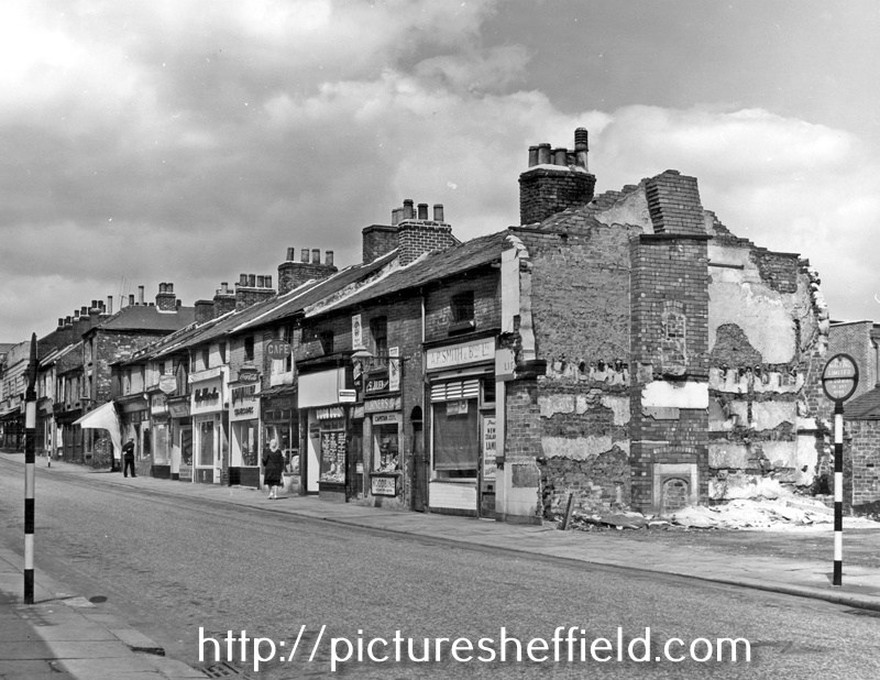
Not Part of the Shops built by Thomas Rowbotham. H. Thomas, horse flesh dealer, No. 28 Hereford Street. Sign reads: Horse Flesh Human Consumption. rb00024 Photographer: Ray Brightman, FRPS AFIAP DPAGB Hon PAGB. From The Ray Brightman exhibition collection. Hereford Street, premises include Peter Worth, Estate, and Insurance Agents, No 26, Jn. Mace Ltd., Pet Stores, No 28, H. Thomas, Horse Flesh Dealer, No 30, William Marsden and Son, Bakers. March 1965. s17124 Photographer: Estates Surveyors Department. Hereford Street at junction with South Lane, premises include No. 21 City Exchange, secondhand radio and television supplies, Nos. 23 - 25 Yospa Gordon, retail jeweller, No. 27 Wm. Talbot, Butcher. March 1965s17129 Photographer: Estates Surveyors. Hereford Street at Forge Lane junction, looking towards The Moor, No 14, Thos. J. Austin and Sons (Butchers) Ltd., No 10, Telefusion Ltd., Television Supplies. March 1965.s17122 Hereford Street after the demolition of Nos. 45 - 47 Bridge Inn, premises still remaining include No. 41 A.P. Smith and Bros. Ltd., butchers, No. 39 Fras. Turner, tobacconist, No. 35, Ernest Speechley, snack bar. July 1961.s17120 Photographer: J Lythgoe.
-

Birley Collieries Branch Line
RLongden replied to Paolo Coopio's topic in Sheffield Buses, Trams and Trains
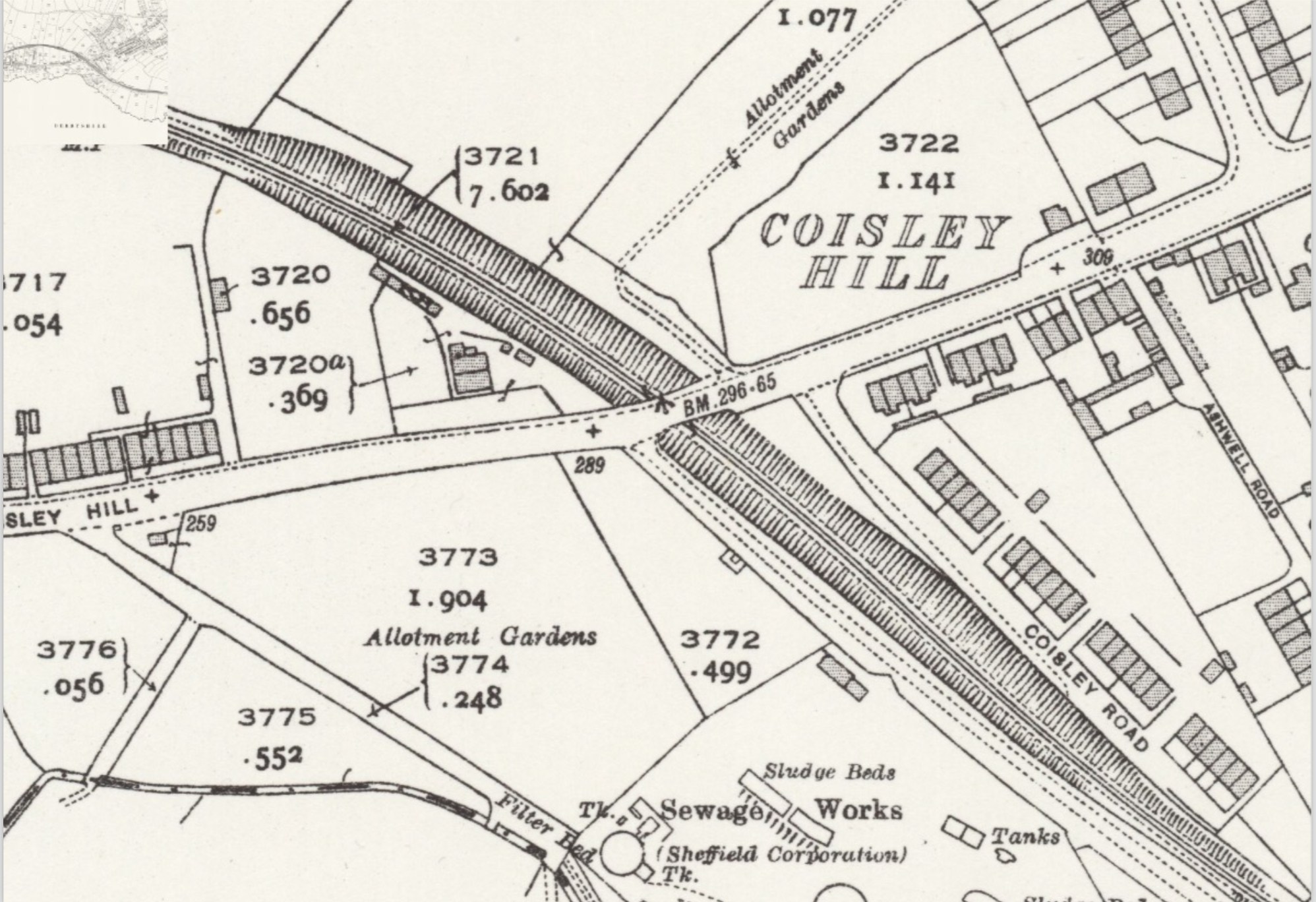
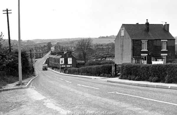
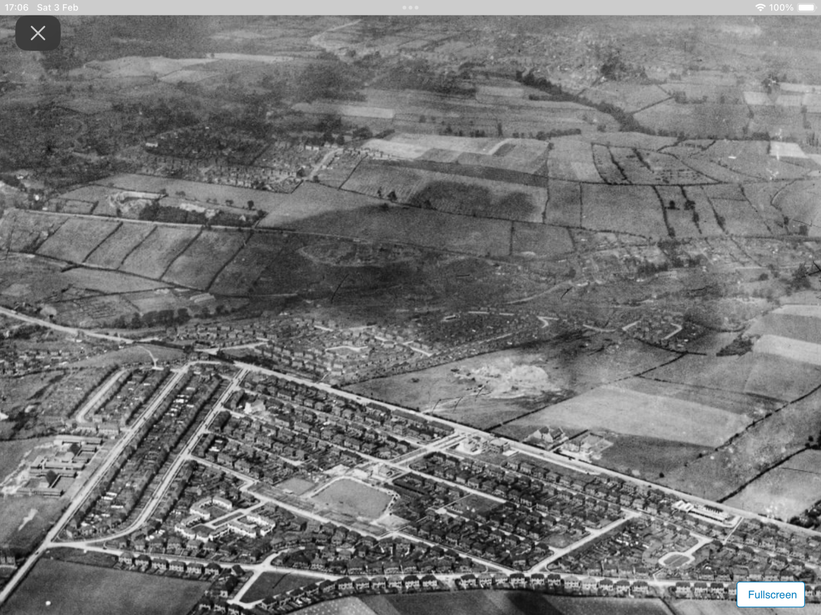
Yes you’re right, the line was in a cutting as it went under Coisley Hill, as you can see from the map detail https://maps.nls.uk/view/125651476 Also, you can see in the image, the photographer must have been stood on the pavement on the bridge, with Stone Lane to their left and the two cottages on the right… the rail line is just out of shot on the right. https://www.picturesheffield.com/frontend.php?keywords=Ref_No_increment;EQUALS;s43471&pos=11&action=zoom&id=85665 An aerial view from 1939, taken over Frecheville, looking over towards Stradbrooke Road, you can see Birley West Colliery in the junction of Linley Lane and Normanton Hill. The rail line passes under Normanton Hill, curves right in an arc, through the fields and it disappears off the right edge of the page, before it crosses Coisley Hill. https://www.britainfromabove.org.uk/en/image/EPW062831 Amazing really that roads and houses have encroached on the area, yet the route it still visible today 😁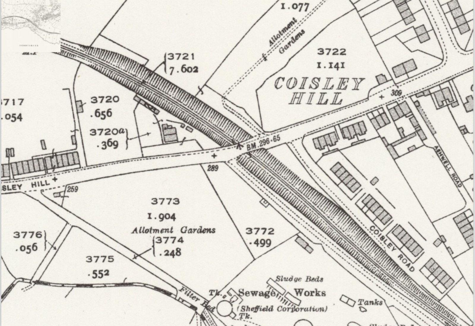
-
Interesting that Curr's The Coal Viewer, and Engine Builder's Practical Companion is of 1797. It describes in detail a Newcomen engine, but no mention of the Watt engine which had come onto the market in 1776 - quite a revolutionary year.
-
Fatal accident at Nunnery Colliery
History dude replied to dereklevesley's topic in General Chat (Anything Goes)
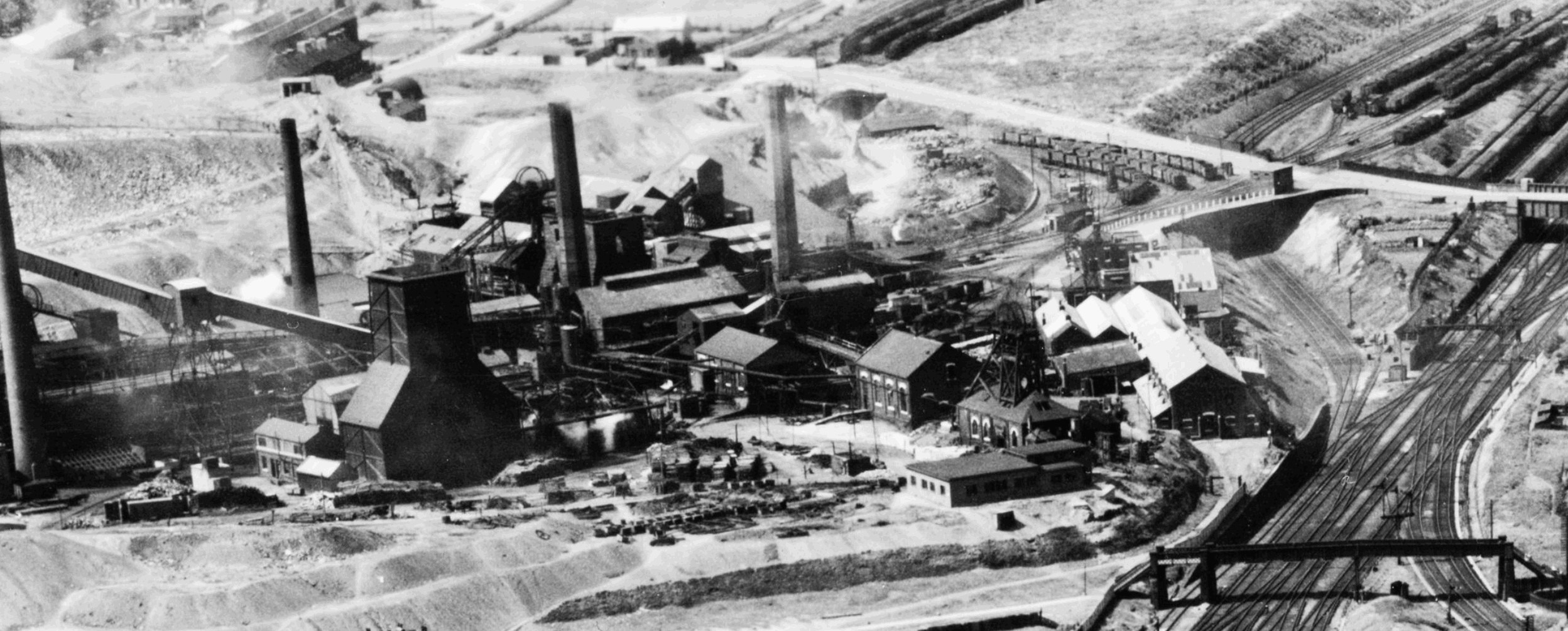
I think you mean Nunnery Colliery. Inquests are often covered in the local newspapers. There's an image below of the pit in 1951.
-

Tram - Origin of the Name?
Edmund replied to dunsbyowl1867's topic in Sheffield Buses, Trams and Trains
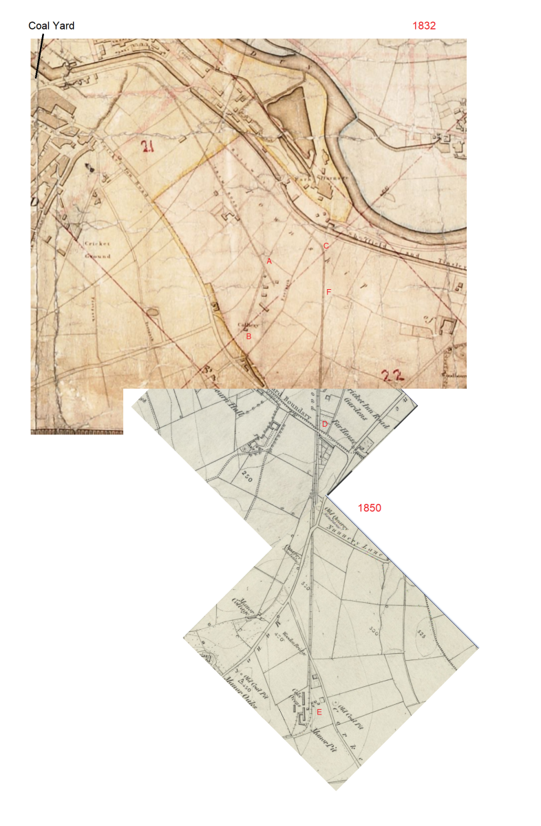
The engraving of the Sheaf Works deserves more credit for accuracy. It depicts the Works where they butt up to Maltravers Road, and even shows the weighbridge at the junction with the canal (as per 1:500 1890 plan). At far left is the work in progress Victoria Station Approach. The bridge carries the Manchester, Sheffield and Lincoln Railway. It does accurately depict the tramway running parallel and close to the canal (following Blast lane where it now passes under Derek Dooley Way). Presumably this section parallel to the canal had to be horse drawn as it was (obviously) flat - as opposed to sections where gravity might assist. Mostly for my own understanding of the situation, and I don't think it will add a great deal of new information, but here is a map I put together from 1832 (Tayler) and 1850 (OS) pieces. EDITED in RED: The tramway to the Sheffield Park Unidentified Colliery at B never crossed Cricket Inn Road as the pit was to the north of it. Heading out of Sheffield marked "Tram Road", at the Cricket Inn Engine House (now under South Yorks Police HQ car park, Point A on Tayler's 1832 map below) the tramway turned 45 degrees to the right and up to the Park Unidentified pit (now under Matalan's car park just south of the Parkway, B on Tayler's map). The tramway to the Manor Colliery (marked "rail way" on Taylor's map) split from the Park Unidentified Colliery tramway and continued parallel to the canal until it reached where Lumley Street is now, outside the Veolia plant (C on map) and turned 45 degrees to the right. It then headed in a straight line, first passing underneath the steam railway line (F on map, just north of the current Nunnery Square Supetram station), and crossing Cricket Inn Road (D on map,where now is the south east corner of the Storebox Self Storage compound (next to roundabout at junction of Cricket Inn Road / Woodbourn Road) then down to the Manor Pit (E on map) and the to the adjacent Manor Wood pit. The Cricket Inn Road Engine (point A) was at the top of a long downhill section and was fairly substantial with two boilers - possibly this Tram Road had mechanical assistance at some point in its history? Sheffield Archives have: Ref: ACM/MAPS/SheD/744L A Plan of the New Railway to the Manor Colliery showing the land taken by Messrs. Hounsfield Wilson and Co. from Sundry Tenants in order to make the same and for other purposes connected with the Colliery. The railway runs by the side of the canal for a short way, then crosses Cricket Inn Road and Manor Lane: fields affected by the railway included and tenants named and listed with acreages. Date c.1830 - does this mean that only the tramway to the Sheffield Park pit was built in the eighteenth century and not the route to the Manor Pit?

-
Plan showing West Hill, home of Fairbank. (left side of plan) Broomhall Street. The Burgesses land between West Street and the Moor (Blacklands, Lee Close), [1793], [1816] https://www.picturesheffield.com/frontend.php?keywords=Ref_No_increment;EQUALS;arc04065&pos=113&action=zoom&id=97106 On this have been plotted the streets laid out up to 1816, and measures of the coalpit added. The additions include Earl Fitzwilliam’s and the Duke of Norfolk’s allotments. Shows Glossop Road, West Street, Devonshire Street, West Hill, West Field Terrace, Division Street, Rockingham Street, Blackland Street, Button Lane on Little Sheffield Moor, Carver Street [and Fitzwilliam Street]. [Site of Devonshire Green]. Also James Bowden’s Land, J. T. Younge’s land, James Kirkby’s house, Upper, Middle and Lower Blacklands Close.
-

The Estate of Joseph & William Wilson (Snuff Mills, Sharrow & Ecclesall etc.)
Ponytail posted a topic in Sheffield History Chat
Plan of the Snuff Mill, Cutler's Wheel, adjoining the Dam etc at Sharrow Moor, occupied by Joseph Wilson and Edwd. Anderton. 1764. https://www.picturesheffield.com/frontend.php?keywords=Ref_No_increment;EQUALS;arc02724&pos=63&action=zoom&id=92116 Map of the Estate of Joseph and William Wilson, Ecclesall Road, 1820. The watermark is 1819: Ecclesall Road (finished 1817) has been made; and J Wilson and Co. had nearly all their lands surveyed in 1820. Also shows Hunter House and Hunters Bar. https://www.picturesheffield.com/frontend.php?keywords=Ref_No_increment;EQUALS;arc03950&pos=39&action=zoom&id=102036 The estate of Joseph and William Wilson. Plan of Clifford, Psalter Lane, and Sharrow Mills, [c. 1820] Shows Clifford (with pleasure ground and gardens), workhouse [on Psalter Lane], West Brook, River Porter, weir, Sharrow Mills (with dam and banks and stack yard), lodge, school, [Ecclesall Road], [Sharrow Vale Road]. https://www.picturesheffield.com/frontend.php?keywords=Ref_No_increment;EQUALS;arc06147&pos=46&action=zoom&id=101163 Plan of several estates in the townships of Ecclesall Bierlow and Nether Hallam, the property of Joseph and William Wilson [c. 1825-1830] The watermark is 1825. https://www.picturesheffield.com/frontend.php?keywords=Ref_No_increment;EQUALS;arc03951&pos=40&action=zoom&id=102040 Map of the Estate belonging to the late William Wilson lying between Sharrow Mills and Endcliff Woods made to shew to whom each part now belongs, [watermarked 1838] https://www.picturesheffield.com/frontend.php?keywords=Ref_No_increment;EQUALS;arc03955&pos=44&action=zoom&id=102361 Field names, etc. not marked. Based on arc03953 and arc03954 they are: Wood Field, Long Field, Spring Field, Square Field, Upper Delf Field, Endcliffe Wood, Endcliffe Vale Road, Clarke House Road (sic) later Brocco Bank, Turnpike Road [Ecclesall Road], Occupation Road, Brocco Bank Allotment, Botanic Garden, Nether field, Great Tom Field, Wadbro rsquo; Close, quarry, Little Tom Field, Brocco Bank Close, River Porter, Lower Delf Field, [Hunters Bar] Toll Bar, Hunter House, Lescar Wheel, Lescar Wheel Road [later Sharrow Vale Road, homestead, [Sharrow Snuff Mills], Walsh Stubbings, The Meadow, Meadow of Walsh Stubbings, Holme Meadow. [Snuff Mill Lane, Stalker Lees Road, General Cemetery, Rosedale Road, Cemetery Avenue, Harefield Road, Denham Road, Harland Road, Neill Road, Eastwood Road. Meadow Terrace, Clarkehouse Road, Botanical Gardens, Endcliffe Vale Road, Botanical Road, Rossington Road, Wiseton Road, Newington Road, Endliffe Terrace Road, Endcliffe Rise Road, Wilson Road, Dover Road, Wadbrough Road, Southgrove Road, Broomgrove Road, Collegiate Crescent, Thompson Road, Khartoum Road, Walton Road, Bristol Road, Bagshot Street, Bruce Road, Westbrook Bank, Stewart Road, Ratcliffe Road, Jarrow Road, Gordon Road, Lynton Road, Wayland Road, Bowood Road]. Map of the Estate belonging to the late William Wilson lying between Sharrow Mills and Endcliffe Wood, made to shew each parcel of land described in the purchase deeds, [Watermarked 1844] Shows Toll Bar and position of Gates. https://www.picturesheffield.com/frontend.php?keywords=Ref_No_increment;EQUALS;arc03954&pos=43&action=zoom&id=102360 Map of the Estate belonging to the late William Wilson lying between Sharrow Mills and Endcliffe Wood made to shew to whom each part now belongs, c. 1850. https://www.picturesheffield.com/frontend.php?keywords=Ref_No_increment;EQUALS;arc03953&pos=42&action=zoom&id=102052 -
West Field House not identified on this Plan but comparing it to the previous map posted it's probably the grey shaded property next to West Field Terrace. Broomhall Street. The Burgesses land between West Street and the Moor (Blacklands, Lee Close), [1793], [1816] https://www.picturesheffield.com/frontend.php?keywords=Ref_No_increment;EQUALS;arc04065&pos=30&action=zoom&id=97106 On this have been plotted the streets laid out up to 1816, and measures of the coalpit added. The additions include Earl Fitzwilliam’s and the Duke of Norfolk’s allotments. Shows Glossop Road, West Street, Devonshire Street, West Hill, West Field Terrace, Division Street, Rockingham Street, Blackland Street, Button Lane on Little Sheffield Moor, Carver Street [and Fitzwilliam Street]. [Site of Devonshire Green]. Also James Bowden’s Land, J. T. Younge’s land, James Kirkby’s house, Upper, Middle and Lower Blacklands Close. Royal Hospital - Ground Plans showing how the site was developed. 1930. Plans of 1833 building (Westfield House), 1860, 1880, 1895, 1912 and 1927. https://www.picturesheffield.com/frontend.php?keywords=Ref_No_increment;EQUALS;h00010&pos=26&action=zoom&id=3905
-

The Tangerine Cafe on Leppings Lane
Sheffield History posted a topic in Sheffield Restaurants & Cafes
Does anyone know anything at all about The Tangerine Cafe on Leppings Lane? Anyone remember it? -
Tram - Origin of the Name?
Edmund replied to dunsbyowl1867's topic in Sheffield Buses, Trams and Trains
For reference, here's a timeline of coal related happenings in Sheffield: Timeline 1736 Gosling's Survey shows a Coal Yard 80 yards east of Shrewsbury Hospital 1737 John Bowden of Beighton leased pits at Sheffield, the Park, Attercliffe and Darnall Common from the Duke 1757 On the expiry of the Bowden lease the Duke took the Wood pits (Sheffield Park colliery) and Manor colliery back into direct management 1765 Duke leased Sheffield Park pits and Manor pits to Townsend and Furniss 1773 Estimate for timber waggonway prepared (probably by Curr) 1774 Wooden tramway laid down and destroyed 1775 Curr had cast-iron plates made to his own pattern by Outram, and placed on (apparently) wood running in the same direction - that is longitudinally 1777 Outrams design of flanged rails laid. Wooden transverse sleepers added, then cast iron boxes, then stone blocks 1779 Gander Lane Turnpike opened (Intake Road, now City Road) 1781 Duke takes collieries into direct management, Curr appointed Superintendent 1797 Publication of Curr's book "The Coal Viewer and Engine Builders' Practical Companion" 1801 Curr dismissed by Duke from Superintendent post 1805 Manor Colliery renamed as Woodthorpe Colliery 1819 Sheffield-Tinsley Canal opened, basin adjacent to coal yard 1823 February - Sheffield Colliery near canal basin opened 1830 George Stephenson report suggests a rail way from the canal basin to "Manor pit and beyond" -resulted in Jessop type flanged wheel rail way to Manor pit 1836 November - Deep Pit at Intake Road opened 1838 October - Sheffield & Rotherham Railway opened (first locomotive railway in Sheffield) -
A map of the land taken for the use of the White-lead Work, with the Buildings etc. 1759. White Lead Works and the fields between the Porter and the Sheaf, on either side of (Leadmill Road). Boatman's Bridge. Pond Street (south end). Surveyor: William Fairbank I. https://www.picturesheffield.com/frontend.php?keywords=Ref_No_increment;EQUALS;arc03403&pos=1&action=zoom&id=98646 A plan of several gardens in Pond Lane held by sundry persons of the Duke of Norfolk, and a plan of the course of the pipe conveying water from the Bath through them to the White Lead Works, [1777] Reference: [?leased] by the Whitelead Company of the Earl of Surrey. The White Lead Mill, cutlers wheel, dwelling houses, stackhouses and all the other buildings; Alegar yard, middle yard, litter yard, yard betwixt the damm and the mill, court by the mill. Also marked tilt damm, goight, River Porter, Boardman's Bridge, Pond Lane, John Waterhouse's tenement, William Nicholson, Thomas Needham, Robert Burnand, William Woolhouse, Widow Beard, Lydia Marriott, Nathaniel Cosins, John Burkett, Peter Spencer, John Wigfall, William Ruddinforth, and James Hattersley's land. https://www.picturesheffield.com/frontend.php?keywords=Ref_No_increment;EQUALS;arc04203&pos=11&action=zoom&id=105138 A plan of the Farm lately held of the Duke of Norfolk by Geo. Calton, with the Whitelead Works, etc. erected thereon. Surveyor: [William Fairbank II]. Fields between the Porter and the Coach-and-Six Farm and between the White Lead Works and the Corn Mill dam; Lead works and Cutler's Wheel clearly marked; numerical list with field names and descriptions and acreages; Proposed new course of the River Porter added, with new acreages listed. (Shoreham Street, Arundel Street, Brown Street, Furnival Street, White Lead Works, Leadmill Road, Leadmill Street, Matilda Lane, Matilda Street, Pond Street (south end), St Mary's Road) White Lead Works and the fields between the Porter and the Sheaf, on either side of (modern Leadmill Road) https://www.picturesheffield.com/frontend.php?keywords=Ref_No_increment;EQUALS;arc03404&pos=2&action=zoom&id=98647
-
St Hilda's Windmill lane. Dances, guides, brownies, fetes, fancy dress, jumble sales. Shows etc. always something going off and our early life revolved around church. Another church now gone - we got married there and celebrate our 60th anniversary next month. Shiregreen school on Bracken road after school - called a play centre. Dancing, different rooms had different interests be it just reading, craft work, jigsaws, games.
-
Silverstones old shop on Campo Lane
tozzin posted a topic in Sheffield in Films and TV shows (Sheffield Filming Locations)
I can remember a few years ago now the D.I.Y. shop on Campo Lane, it was called Silverstones, it was a very popular shop for home improvement enthusiast but probably because of big stores opening up it took its toll on Silverstones and the shop closed, it stood empty and boarded up for a while - but - a film crew arrived and Silverstones was chosen to be dressed for scenes in the film and here’s my problem, I can’t for the life of me remember what the film was called or who starred in it, can anybody enlighten me? -
Hi all, I recently (around 3 years ago) moved to the corner of Derbyshire lane just as it turns into Hemsworth Road. The Mrs's mother says she remembers visiting our house and the one next door on way to and from school as they were both a sweet shop and a flower shop. Would anyone have any photos of this? My neighbor says she does have photos which are in loft and I've pestered quite a while to see them but i don't want to keep going on. I've tried searching on here but with no luck so far. I really would love to see these photos to show the mother in law and perhaps get them printed and placed somewhere in the house. Any help is greatly appreciated.
-
Dixon Lane, bridge over the river.
Ponytail replied to Roger Stevenson's topic in Sheffield History Chat
Property on the corner of Castle Folds and Broad Street, on the bank of the River Sheaf, [1821-1827] https://www.picturesheffield.com/frontend.php?keywords=Ref_No_increment;EQUALS;arc03421&pos=3&action=zoom&id=98685 The site of Castlefolds Market. Shows Dixon Lane & Hospital Bridge. Needs a bit of manipulation to view. Scanned upside down. Plan of the property on the west bank of the River Sheaf, between the Hospital bridge and the bridge leading to the Canal basin [Exchange Street], [c. 1817-1821] https://www.picturesheffield.com/frontend.php?keywords=Ref_No_increment;EQUALS;arc03420&pos=2&action=zoom&id=98683 Premises numbered and listed with tenants and yardages. Tontine Inn. (site of Castlefolds Market). Dixon Lane. -
The Jolly Bacchus Pub on Holly Lane in Sheffield City Centre
Sheffield History posted a topic in Sheffield Pubs and WMC's
Does anyone have any other information or ideally a photo of The Bacchus Public House on Holly Lane in Sheffield City Centre? (between the back of Sheffield City Hall and West Street) As you can see by the auction poster the Jolly Bacchus Pub and outbuildings were auctioned off in 1870 and I wondered what Holly Lane would have looked like back then The poster reads: Valuable freehold premises in Holly Street and Holly Lane to be sold by auction, by Messrs W. H. and J. A. Eadon at their auction mart, St James’ Street, Sheffield, on Thursday, October 20, 1870 at four o’clock in the afternoon, by order of the Devisees in Trust under the will of the elate Mr Joseph Bendelow, subject to the conditions of sale - the public House with the yard and outbuildings thereto, known by the sign of The Jolly Bacchus. Situate in Holly Lane, Sheffield, in the occupation of Messrs Williams Greaves and Co., or their undertenants, as yearly tenants; and eight messuages or tenements, with a warehouse and other buildings, two of the houses being used as retail shops, and fronting to and being Nos 34 and 38 in Holly Street, Sheffield, and in the respective occupations of Messrs Wood and Furguson, and the others being in the yard behind, and in the respective occupations of Messrs Fowler, Osborn, Underwood, and Large, and comprising the premises whereon the late Mr Joseph Bendelow carried on for many years the business of a plasterer and whitewasher. The site of the whole of the premises, which extend from Holly Street to Holly Lane, contains 482 superficial square yards or thereabouts. Further particulars may be obtained from the auctioneers; or from Messrs Brown and Son, solicitors, 1 St James Street, Sheffield. J. M. Jubb, Printer, Prior Court, High Street, Sheffield.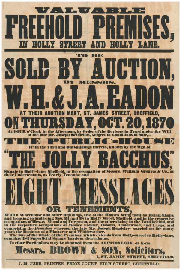
-
What does "main" mean in a colliery name ?
Ponytail replied to JS2021's topic in Sheffield History Chat
As discussed the first pit sunk in the town was often called Main. Never considered it before, was there ever a Sheffield Main Colliery? Sheffield Collieries at Work 1869. https://www.chrishobbs.com/sheffield/1869shefpits.htm https://en.m.wikipedia.org/wiki/Sheffield_Coal_Company -
What does "main" mean in a colliery name ?
Ponytail replied to JS2021's topic in Sheffield History Chat
Referring to Maltby Main F.C. when they were formed about the time WWI all the players worked at Maltby Main. Other Collieries and Steelworks had their own sports teams and brass bands, some kept the traditional names when the Pit or the Works closed. They changed the name to Maltby Miners Welfare in 1959 but returned to the original name 1996. -
Mower & Pearson, Brewers, Wine and Spirit Merchants, Scotland Street & Pea Croft
Ponytail replied to Ponytail's topic in Sheffield Pubs and WMC's
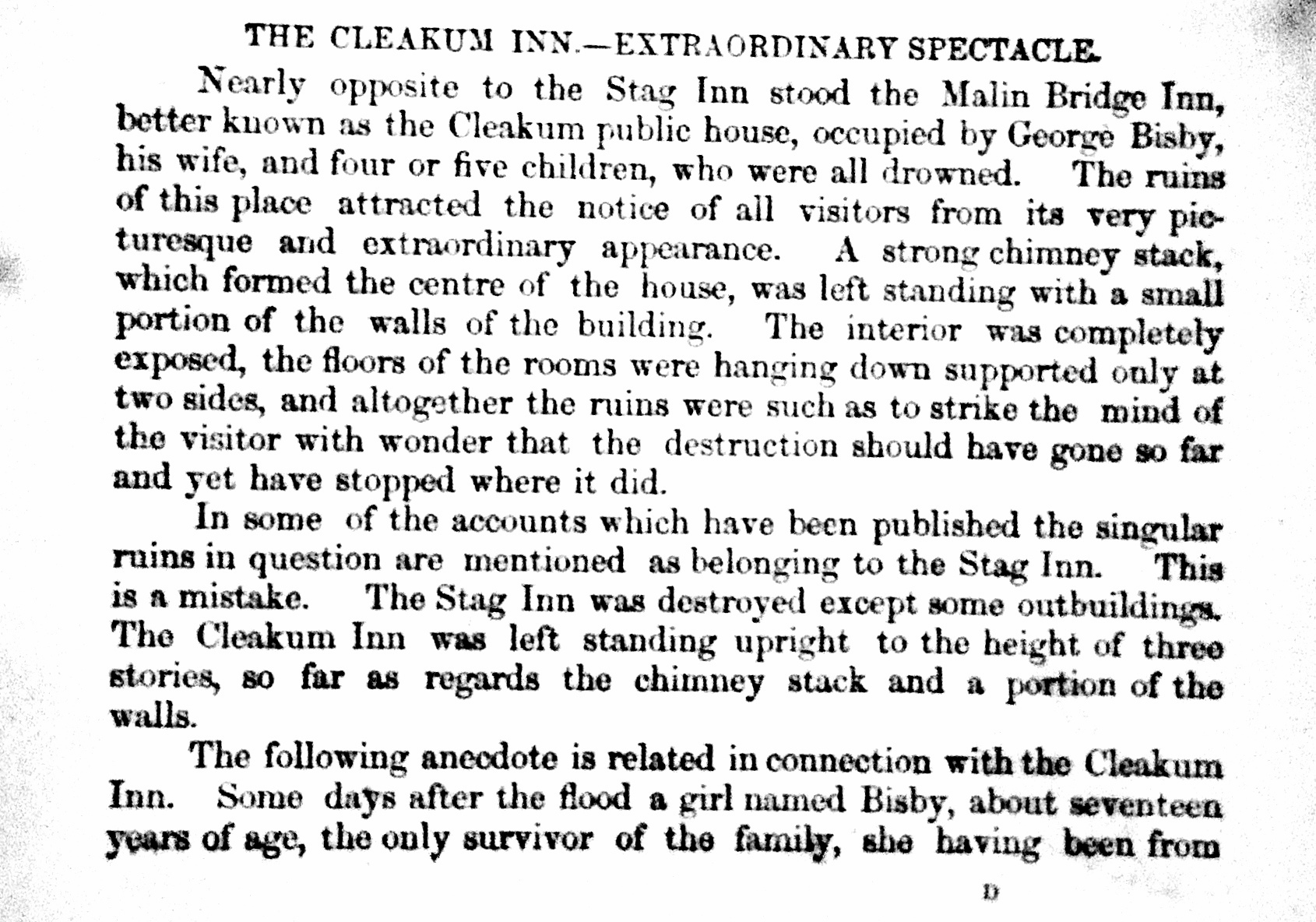
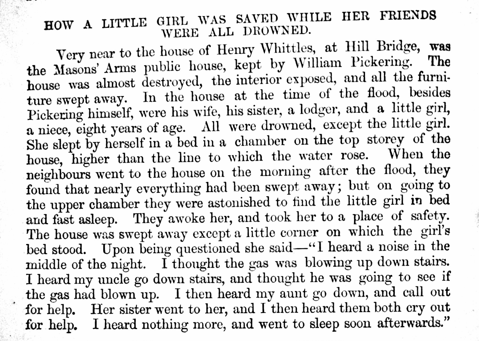
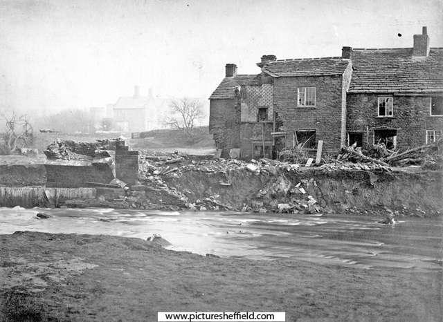
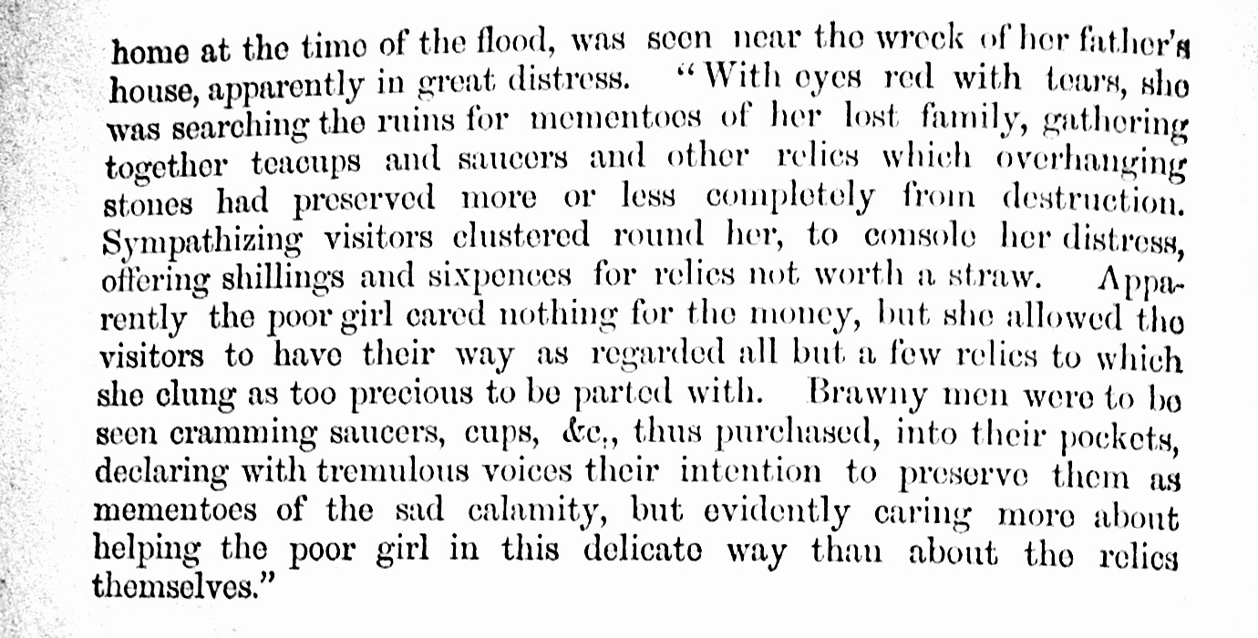
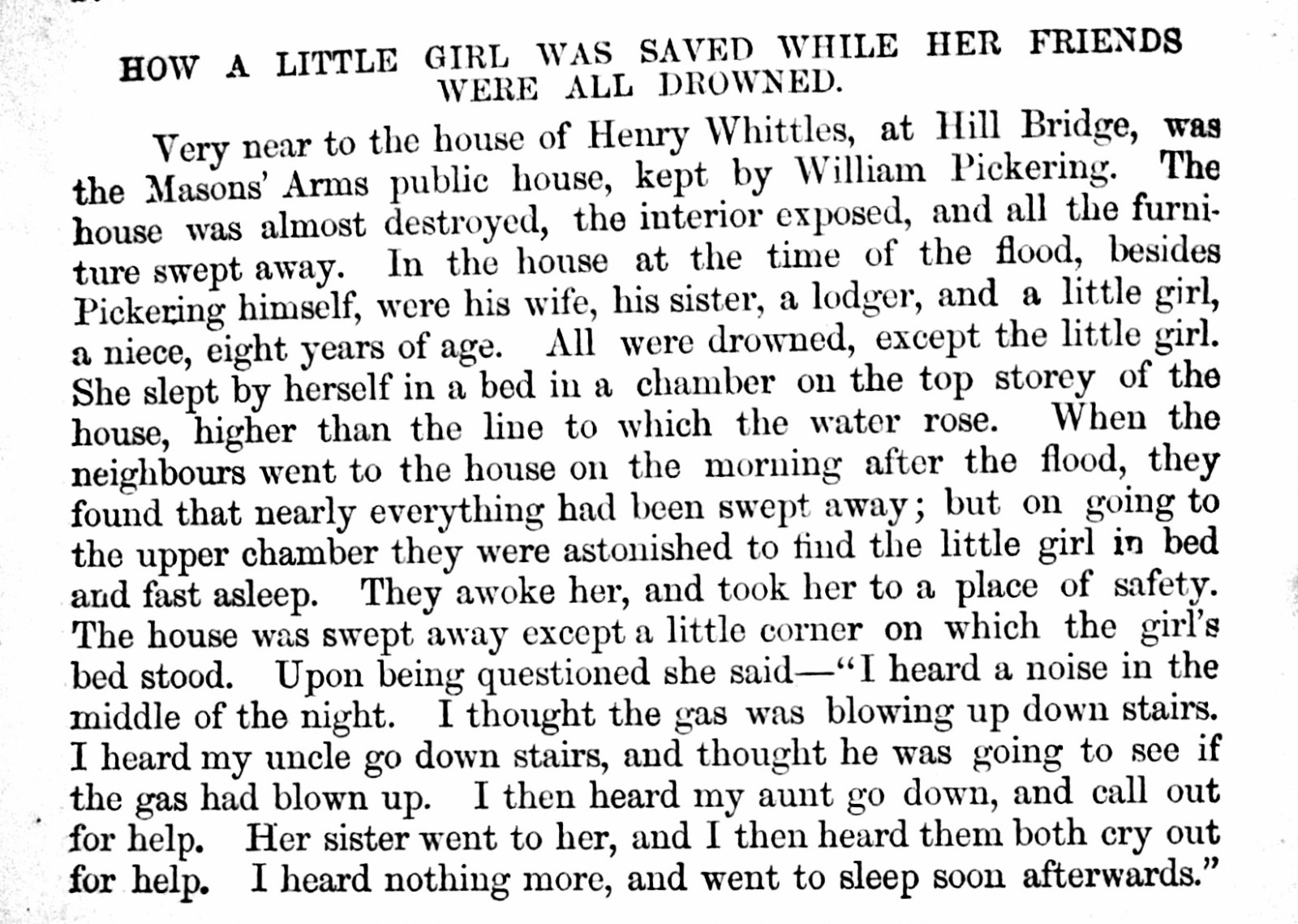
Sheffield Flood Claim: Nathaniel James Fewsdale Mower, wine merchant, Scotland Street Public House called Malin Bridge Inn, occupied by Mr. Bisby with Stabling, Outbuildings and Conveniences completely destroyed. https://sheffieldfloodclaimsarchive.shu.ac.uk/claimSummary.cfm?claim=7-5915 Picture Sheffield s00584 Artist, Drury, Malin Bridge Inn also known as Cleakum Inn. https://www.picturesheffield.com/frontend.php?keywords=Ref_No_increment;EQUALS;s00606&pos=10&action=zoom&id=4507 Nathaniel James Fewsdale Mower and Henry William Pearson, wine merchants and brewers, Scotland Street To Furniture and Effects in Public House called Malin Bridge utterly lost. Tennant, Mr. Bisby. To Casks and Bottles lost and destroyed in the possession of various Customers to whom they had been lent until empty: William Pickering, Hillsbro'. George Bisby, Malin Bridge Inn. Alfred Hinchliffe, Orchard Lane, Harvest Lane. William Hawksley, Bower Spring. Charles Price, Malin Bridge Hobson Peace, Owlerton Road. James Hewitt, Hillfoot. Mrs. Harper, Shalesmoor. Frederick Shaw, Damflask. William Robinson, Orchard Lane, Harvest Lane. George Greaves, Wicker. William Heppenstall, Corporation Street. Thomas, Sykes, Royal Oak, Saville Street. John Pilling, Princess Street. John Stringer, "Ball" Green Lane. Francis Todd, Iron Bridge. Mrs. Rowe, Saville Street. Charles Stainforth, Green Lane. John Frith, "Cup" Dun Street. William Riley, Neepsend Lane. G. F. Gardener, Neepsend Brewery. Edward Parkin, Spring Street. Samuel Alvey, Harvest Lane. https://sheffieldfloodclaimsarchive.shu.ac.uk/claimSummary.cfm?claim=7-6136 Sheffield Flood Claims: Personal Claims for licencees who Mower & Pearson had claimed for the Casks and Bottles "lent" William Pickering, claim by Mower & Pearson names him of Hillsbro'. Pickering was licensee of the Free Masons Arms, Hill Bridge. s00969 Remains of Hill Bridge and Free Masons Arms, junction of Limbrick Lane right. From "History of the Flood at Sheffield" Claim for deceased William Pickering and others at the Freemason Arms https://sheffieldfloodclaimsarchive.shu.ac.uk/claimSummary.cfm?claim=9a-59 https://sheffieldfloodclaimsarchive.shu.ac.uk/claimSummary.cfm?claim=9a-58 https://sheffieldfloodclaimsarchive.shu.ac.uk/claimSummary.cfm?claim=5-4376 Property lost at the Freemason Arms. https://sheffieldfloodclaimsarchive.shu.ac.uk/claimSummary.cfm?claim=5-4385 George Bisby, carter and Innkeeper, Malin Bridge. Died. Funeral expence, maintenance of daughter, Emma. Estate and Effects. https://sheffieldfloodclaimsarchive.shu.ac.uk/claimSummary.cfm?claim=3-2756 From "History of the Flood at Sheffield" Alfred Hinchliffe, grocer, 9 Orchard Street, Harvest Lane. https://sheffieldfloodclaimsarchive.shu.ac.uk/claimSummary.cfm?claim=10-53 William Hawksley, Bower Spring. Probably, Ann Hawksley, widow and publican, Rifle Tavern, Bower Street. https://sheffieldfloodclaimsarchive.shu.ac.uk/claimSummary.cfm?claim=5-4633 Ann Hawksley claimed for illness caused by the Flood for herself and daughter https://sheffieldfloodclaimsarchive.shu.ac.uk/claimSummary.cfm?claim=9b-169 Charles Price, Malin Bridge ?? Hobson Peace, Owlerton Road (Probably William Hobson Peace, Silver & Metal Roller, Old Park Mills. https://sheffieldfloodclaimsarchive.shu.ac.uk/claimSummary.cfm?claim=8-6397 Also claimed Montague George Burgoyne Esq, Eaton Sq. for a number of lands & properties (total 22) including (no.19) Old Park Rolling Mills, house, land, cottages and Premises. https://sheffieldfloodclaimsarchive.shu.ac.uk/claimSummary.cfm?claim=7-5975 James Hewitt, Hillfoot ?? Mrs Harriet Harper, widow and publican, Lucknow Tavern Shalesmoor. https://sheffieldfloodclaimsarchive.shu.ac.uk/claimSummary.cfm?claim=5-4353 Frederick Shaw, Damflask. ?? William Robinson, labourer, back of Number 47 Harvest Lane. https://sheffieldfloodclaimsarchive.shu.ac.uk/claimSummary.cfm?claim=6-5319 George Greaves, Brown Cow Inn, 56 Wicker. https://sheffieldfloodclaimsarchive.shu.ac.uk/claimSummary.cfm?claim=6-5117 Brown Cow building owned by William Unwin (Richard Trustwell & Co) https://sheffieldfloodclaimsarchive.shu.ac.uk/claimSummary.cfm?claim=6-5423 William Heppenstall, innkeeper, Corporation Inn, Corporation Street. https://sheffieldfloodclaimsarchive.shu.ac.uk/claimSummary.cfm?claim=4-4101 Thomas Sykes, publican and file cutter, Saville Street. (Mower & Pearson claim, name it as the Royal Oak) https://sheffieldfloodclaimsarchive.shu.ac.uk/claimSummary.cfm?claim=5-4564 John Pilling, beerhouse keeper (unnamed) and coal dealer, Princess Street, Attercliffe Road. https://sheffieldfloodclaimsarchive.shu.ac.uk/claimSummary.cfm?claim=4-4181 John Stringer, innkeeper, The Ball, 84 Green Lane. Claiming for loss of businessas as Ball Street Bridge washed away. https://sheffieldfloodclaimsarchive.shu.ac.uk/claimSummary.cfm?claim=4-3966 Personal property listed then claim withdrawn. https://sheffieldfloodclaimsarchive.shu.ac.uk/claimSummary.cfm?claim=7-5956 Francis Todd, publican, Forresters Arms, Ironbridge. https://sheffieldfloodclaimsarchive.shu.ac.uk/claimSummary.cfm?claim=7-5922 https://sheffieldfloodclaimsarchive.shu.ac.uk/claimSummary.cfm?claim=4-4259 Mrs Mary Rowe, widow Inn keeper, Atlas Inn, Saville Street. https://sheffieldfloodclaimsarchive.shu.ac.uk/notFound.cfm?claim=4-4039 Charles Stainforth, beerhouse keeper, Hallamshire Hotel, Green Lane https://sheffieldfloodclaimsarchive.shu.ac.uk/claimSummary.cfm?claim=4-3801 Claim for Harriet Rodgers at Charles Stainforth at 74, Green Lane. https://sheffieldfloodclaimsarchive.shu.ac.uk/claimSummary.cfm?claim=9b-309 John Frith, publican, The Cup, Dun Street (as tennant to Mr. Edward Hoyland) https://sheffieldfloodclaimsarchive.shu.ac.uk/claimSummary.cfm?claim=4-3449 William Riley, beerhouse keeper and green grocer, Mill Houses (Mills Property) Neepsend Lane. Recorded as both. https://sheffieldfloodclaimsarchive.shu.ac.uk/claimSummary.cfm?claim=1-989 George Frederick Gardener, brewer, Neepsend Brewery Of Westbar late of Neepsend https://sheffieldfloodclaimsarchive.shu.ac.uk/claimSummary.cfm?claim=7-5961 Edwin (recorded as Edward in Mower & Pearson claim) Parkin, publican (House not named) Spring Street. https://sheffieldfloodclaimsarchive.shu.ac.uk/claimSummary.cfm?claim=1-294 Samuel Alvey, publican, Saw Makers Arms, Neepsend Lane (Mower and Pearson Claim records Harvest Lane) https://sheffieldfloodclaimsarchive.shu.ac.uk/claimSummary.cfm?claim=4-3886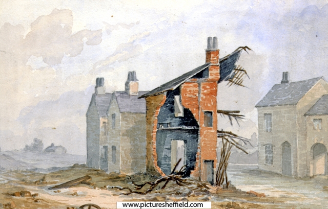

-
Tram - Origin of the Name?
Edmund replied to dunsbyowl1867's topic in Sheffield Buses, Trams and Trains
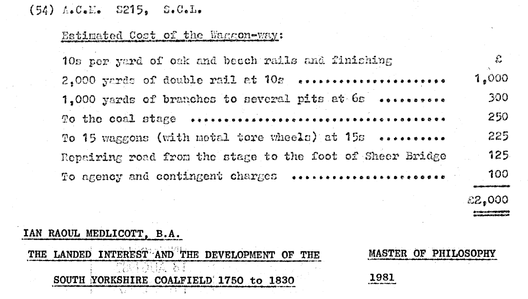
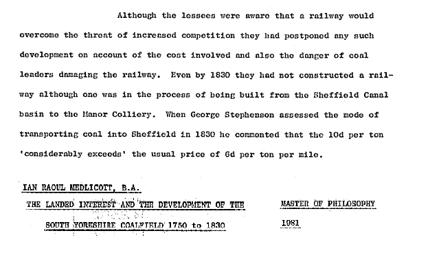
From an article called "New Steam and Old Coal" by R.E.Leader in the Independent dated 23rd June 1900: "The same Duke, the 9th, took a more enlightened course a few years later. Instead of trying to shut out the competition of his tenants and neighbours, he sought, through his manager, Mr Curr, to meet it by facilitating the conveyance of his coals to the town by the then very original means of tramway with wooden rails. This was in 1774, [Note: Curr was not employed at that point] It was two miles long, and the coals were delivered at a depot at the bottom of the Park hill, near where Duke street and South street join Broad street. Instead of being grateful, or "pleased', the foolish people saw in this a deep design to raise the price of coals. In spite of a tariff showing that there was a real saving on the coals as sold at the wharf, the wildest stories were afloat, circulated perhaps by the carters, whose occupation was threatened. The scheme was called an imposition and a cruelty; and "the merciless wretches" as they are called in a contemporary letter, were charged with stopping all delivery at the pits, with seeking to almost double the price, and with refusing to sell in less quantities than a horse load. Serious riots were the consequence. Several of the "large carriages on low wheels, which run on a road made of timber, in imitation of one at Newcastle", were destroyed. A track, after being dragged in triumph through the town, was set on fire and sent flaming into the river. The new loading stage was broken up and burst; a watch hut and the counting house in the coal yard were wrecked, and the tram lines were damaged. The mob also attacked "The Lord's House" in Norfolk Row, where Mr. Henry Howard lived. Mr. Howard promptly issued a handbill pointing out that it was never intended to charge higher prices, and showing how, instead of having this effect, facility of transit must keep them low. He was backed up by a reassuring statement issued by the Town Collector, the Master Cutler, and other leading inhabitants as the result of a public meeting. But the people refused to be comforted, and a few months later the riots were renewed so threateningly that an association was formed for the mutual protection of persons and property. The tramroad was afterwards relaid with iron rails: and it has been contended that it was the first in the country so constructed." Here's the (under) estimate of the cost for the first tram way to Wood Pits (Sheffield Park Pit) in 1774. Presumably the Sheer (Shear) Bridge which led from the coal stage into town across the River Sheaf by the side of the Shrewsbury Hospital, had to be strengthened to cope with the expected increase in useage once the tram way was functioning. EDIT: The road from the coal stage as far as the bridge had to be repaired (not the bridge itself) - this may have been due to the waggon-way needing a sound foundation, and the road having been chruned up by previous coal carts running over it. When discussing the lessees of Norfolk's pits, Medlicott asserts that the railway to the Manor Pit was still under construction in 1830. Sheffield Archives have: Ref: ACM/MAPS/SheD/744L Plan of the New Railway to the Manor Colliery showing the land taken by Messrs. Hounsfield Wilson and Co. from Sundry Tenants in order to make the same and for other purposes connected with the Colliery. (No surveyor named.) The railway runs by the side of the canal for a short way, then crosses Cricket Inn Road and Manor Lane: fields affected by the railway included and tenants named and listed with acreages.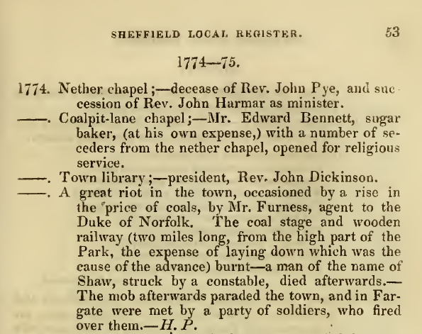
-
Whenever I drive along Yew Lane, in Parson Cross, I am amazed at how wide it is between the houses on each side. Does anybody have any ideas?