Search the Community
Showing results for 'coal pit lane'.
-
Hi Lysanderix. Yes my dad was same as yours . He was born 2 November 1915. He lived on Petre Street & went to All Saints Infants & juniors . Took exam (am sure you are right that it was the Scholarship exam) in 1927 when he went to Owler Lane Intermediate. He left school in summer 1930 age 14. He went to work at Firth Vickers & studied engineering at Sheffield Technical School ( I assume it was night school he went to although am not sure about that - could there have been day release back then ?). Happy Christmas, John
-

What does "main" mean in a colliery name ?
Edmund replied to JS2021's topic in Sheffield History Chat
It appears that the tradition of naming collieries as "Main" originated in the North East at an early date. The "Main" seam coal was so attractive that even collieries that did not extract coal from the Main seam began to use the name, and "Main" became synonymous with Mine" :
-
Wasn’t it called the Scholarship? My Dad and your Dad were of a similar age and he also went to Owler Lane….until he was old enough(14?) to work
-
Ordnance Survey Map, sheet no. Yorkshire No. 294.7.23. 1889. Bottom left next to one another are properties named Broombank House & Broombank Mount. https://www.picturesheffield.com/frontend.php?keywords=Ref_No_increment;EQUALS;q00074&pos=13&action=zoom&id=106999 1850/51 published 1855. OS Map showing Properties labelled Broom Bank. https://maps.nls.uk/view/102345217#zoom=6&lat=5431&lon=9429&layers=BT The House labelled Broombank House, Glossop Road next to Five Oaks on the 1889 Map isn't labelled on the 1850's map. What appears to be 3 separate properties on Glossop Road/Clarkehouse Lane (1850's map) are labelled Broom Bank. "Broom Bank House" built by Francis Newton is above the label "Broomspring Vale" (1850's map) Shown on 1889 OS Map 294.11.3 as "Broom Bank" https://maps.nls.uk/view/231282594#zoom=2&lat=8939&lon=8447&layers=BT
-
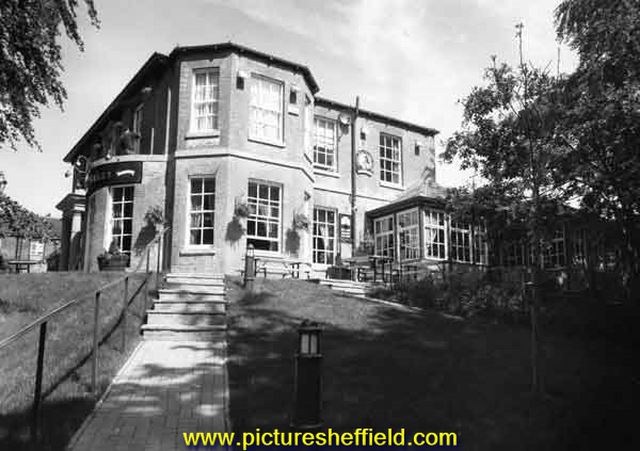
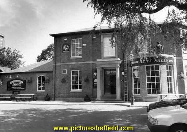
Plan of Broom Bank House and other freehold property situate in Clarkehouse Lane belonging to the late Francis Newton, esquire, to be sold by auction. 13th June 1865. https://www.picturesheffield.com/frontend.php?keywords=Ref_No_increment;EQUALS;y10826&pos=4&action=zoom&id=73501 Aunt Sally public house (formerly Lynwood House and Broom Bank House), Clarkehouse Road. June 1995.s34050 Built for Francis Newton (1796-1864), esquire. s34046
-
My dad James Henry Moore age 12 passed exam (don't know what it was called) whilst at All Saints school to go to Owler Lane Intermediate in 1927.
-

Dixon Lane in Sheffield City Centre
Ponytail replied to Sheffield History's topic in Sheffield History Chat
Map of Sheffield Markets. 1847. Marked: Old Haymarket, Dixon Lane, Castle Folds, Exchange Street, New Market Ground and Fountain, Cheese Market, Corn Exchange, Road Street. https://www.picturesheffield.com/frontend.php?keywords=Ref_No_increment;EQUALS;arc04188&pos=23&action=zoom&id=104947 -
The blue 'police box' next to the town hall
Ponytail replied to Sheffield History's topic in Sheffield History Chat
Police Box, Ecclesall Road South and Abbey Lane junction. 23rd January 1958.s15179 Photographer: City Engineers Department. Nos. 2, 4, 6, Richmond Road, Handsworth (demolished 1960) and Police Box, Handsworth Road. 21st August 1958. t00468 Photographer: Llewelyn Roberts, Medical Officer of Health.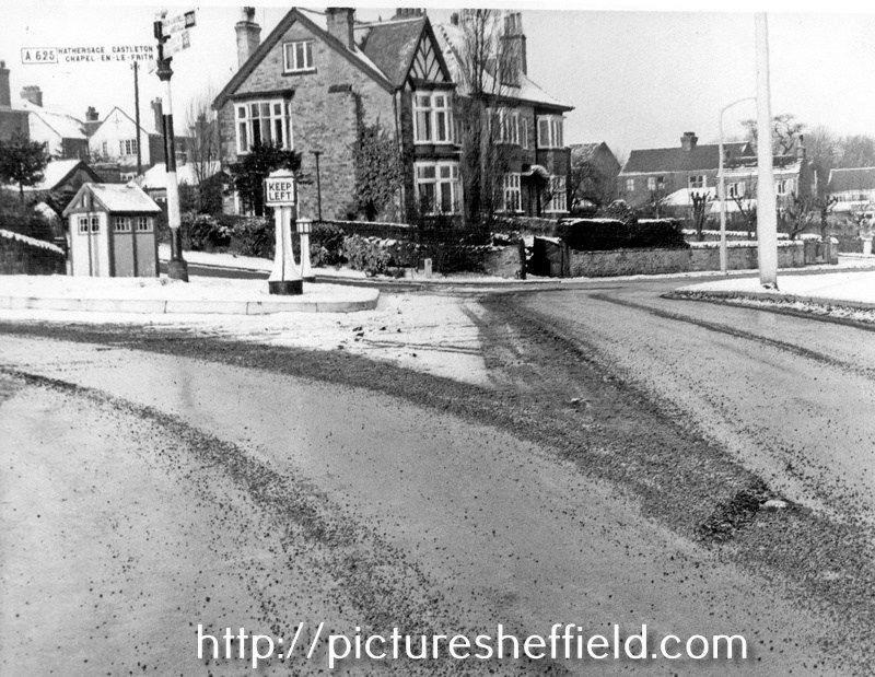
-
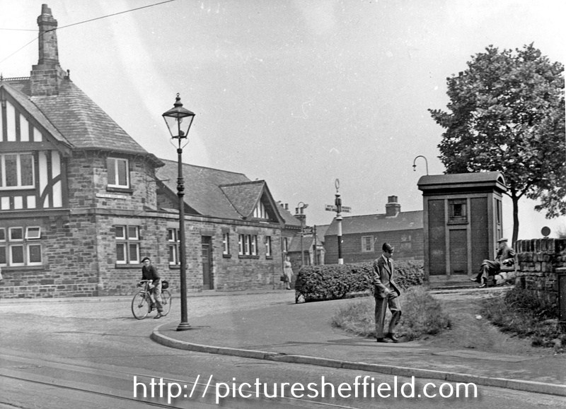
The blue 'police box' next to the town hall
Ponytail replied to Sheffield History's topic in Sheffield History Chat
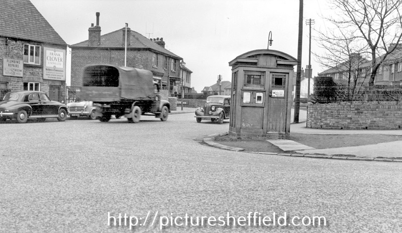
Meadowhead looking towards junction with Greenhill Main Road, Police Box right. 26th August 1966.s17884 Photographer: City Engineers Department. Norton Lees Lane, at junction with Derbyshire Lane, prior to removal of Police Box and (left) Nos. 9-11, Frank Clover and Sons Ltd., builders. 25th March 1954.s18416
-
The blue 'police box' next to the town hall
Ponytail replied to Sheffield History's topic in Sheffield History Chat
Police Box near the junction of Norwood Avenue and Herries Road showing the junction with Longley Lane. 10th November 1960.s17156 Photographer: City Engineers Department. Police Box, Hatfield House Lane at the junction with Barnsley Road. 20th July 1955.s17161 Photographer: City Engineers Department. Police Box, Firth Park Roundabout, January 1949. https://www.picturesheffield.com/frontend.php?keywords=Ref_No_increment;EQUALS;s15827&pos=39&action=zoom&id=18660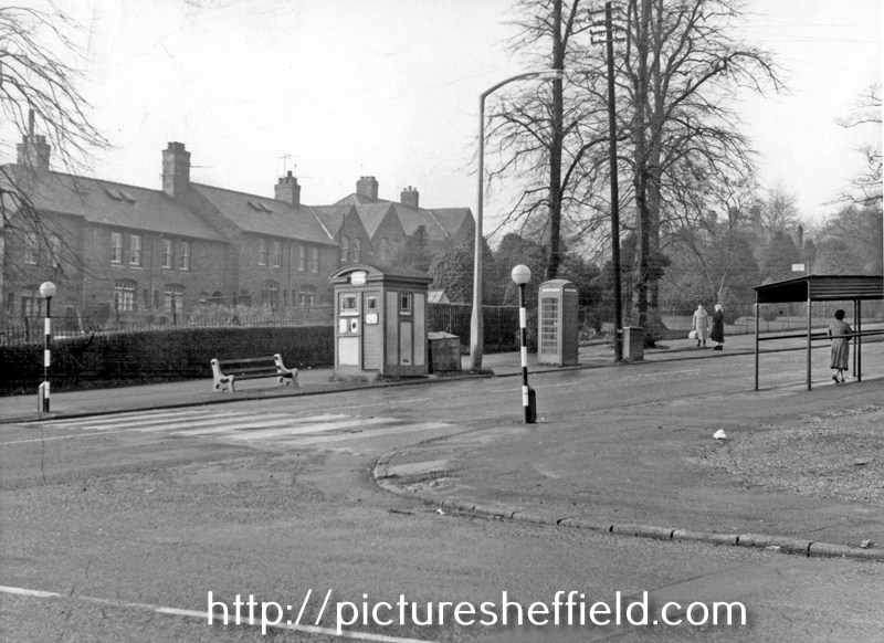
-
The blue 'police box' next to the town hall
Ponytail replied to Sheffield History's topic in Sheffield History Chat
Convent of the Sisters of Charity, St. Vincents House, Broad Lane and Police Box on the corner of Red Hill (on right) September 1938.u00840 Photographer: City Engineers Department. Police Box, Nursery Street, No 30, Chadburns' Lenses Ltd, Opticians (Albion Works), Coroner's Court and Public Mortuary, right. https://www.picturesheffield.com/frontend.php?keywords=Ref_No_increment;EQUALS;v00926&pos=68&action=zoom&id=42718 No date with the photograph.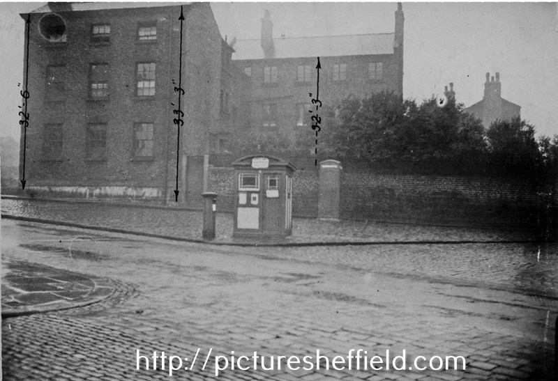
-
Link to: Owler Lane High School. https://www.sheffieldhistory.co.uk/forums/topic/13344-owler-lane-high-school/
-
I went to Infants school at Owler Lane 1949-1951 then on to Grimesthorpe until 1955. After that my parents got me transferred to Hucklow Rd so I could go to Hinde House when it was built in 1956 . It turned out to be a good thing for me as I did well there.
-
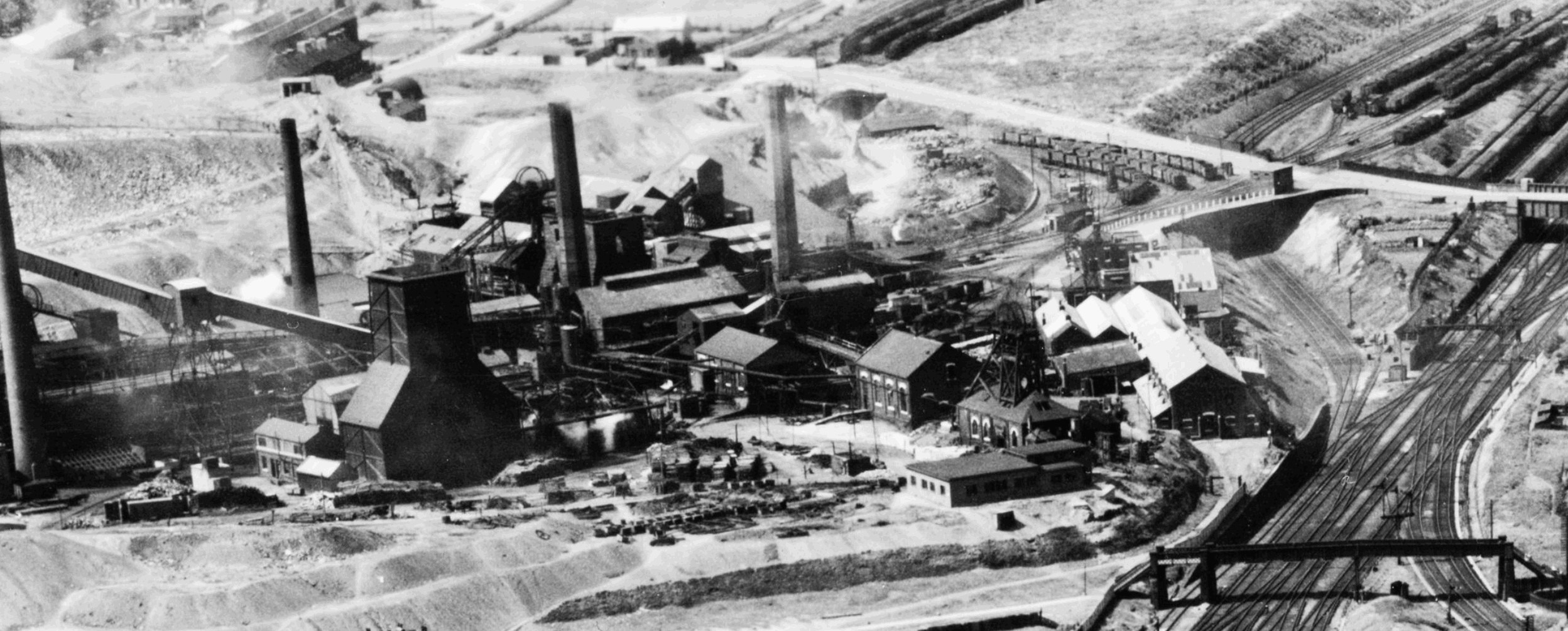
Fatal accident at Nunnery Colliery
History dude replied to dereklevesley's topic in General Chat (Anything Goes)
I think you mean Nunnery Colliery. Inquests are often covered in the local newspapers. There's an image below of the pit in 1951.
-
My granddad Robert sustained a broken spine as a result of being crushed between a full tub of coal and the pit side of Nunnerley colliery on 14 May 1947. He died in the Sheffield Royal Infirmary on the 16th. The coroner for the City of Sheffield raised an inquest on the 17th. Would anyone know if I can see a copy of this? Also, would grandma have received any compensation? Many thanks, Derek.
-
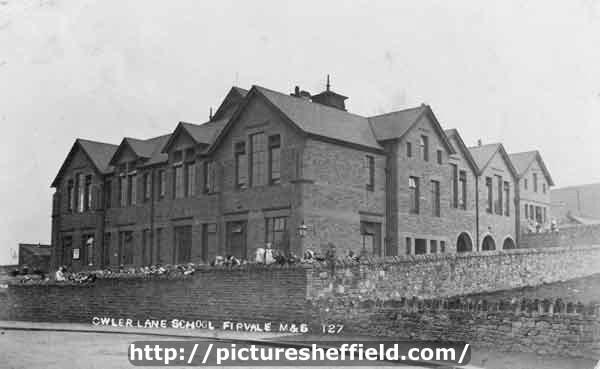
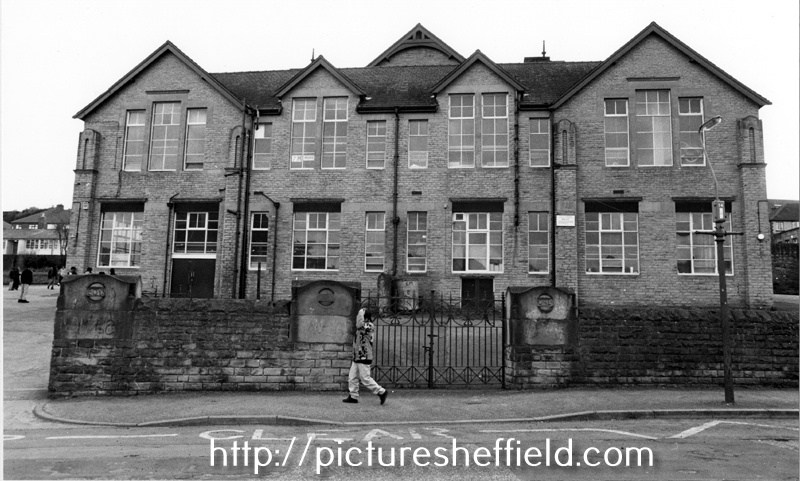
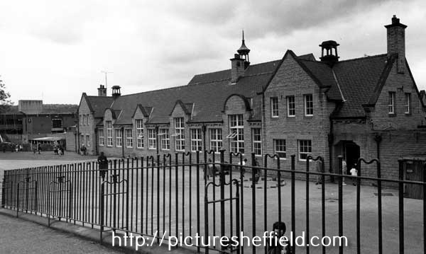
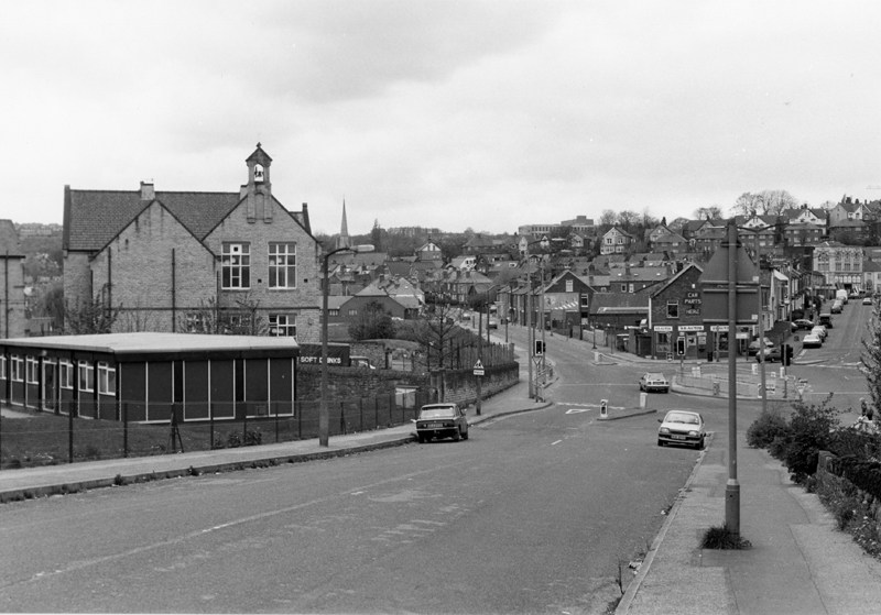
Owler Lane School, Owler Lane. p00100 On this site the original building opened by Rev. J. Gilmore, May 1889; Senior Mixed Department opened by Mr. A.W. Warner, Nov 1901; Infant Department opened by Coun. S. Osborn J.P. Aug 1911. In 1947 re-organised as Secondary (Intermediate), Secondary Modern and Infant School. Secondary (Intermediate) School transferred to Hinde House Comprehensive School 1963. See: City of Sheffield, Education Committee, Handbook of Information, 1964/65. Owler Lane High School (formerly Owler Lane Secondary (Intermediate) School), Owler Lane and the junction with Rushby Street.13th July 1964. https://www.picturesheffield.com/frontend.php?keywords=Ref_No_increment;EQUALS;S24584&pos=18&action=zoom&id=27365 Earl Marshal Campus, formerly Owler Lane Secondary School, Owler Lane showing the old Boys and Girls entrances. 21st April 1993. s24585 Owler Brook Nursery and Infant School formerly Owler Lane County School, Earl Marshall Road. 21st April 1993.s24702 Rushby Street showing Earl Marshall Campus (formerly Owler Lane School) looking towards Owler Lane. 21st April 1993.s26603
-
Old Quaker Burial Ground, Broad Lane. A Plan of Tenements and Ground demised to Ann Twybill [in Broad Lane, one near the Quaker burial ground the other at Broad Lane End] 1791. https://www.picturesheffield.com/frontend.php?keywords=Ref_No_increment;EQUALS;arc03092&pos=17&action=zoom&id=98038 Map of a Close belonging to the Duke of Norfolk now subdivided into gardens, and late under Lease with the Golden Cross in Sheffield. 1777. Shows 'Burying ground of the people called Quakers' and proposed route of Garden Street. https://www.picturesheffield.com/frontend.php?keywords=Ref_No_increment;EQUALS;arc02093&pos=13&action=zoom&id=76286 Plan of a close adjoining to the Broad Lane with the Gardens etc. formerly part of the said Close, and of another Close contiguous there to as it is now d[ivided] into Gardens the whole being the property of the Duke of Norfolk. 1768. Tenants names given. Shows 'Burying ground of the people called Quakers'. https://www.picturesheffield.com/frontend.php?keywords=Ref_No_increment;EQUALS;arc02095&pos=14&action=zoom&id=76290 Were the bodies reinterred?
-
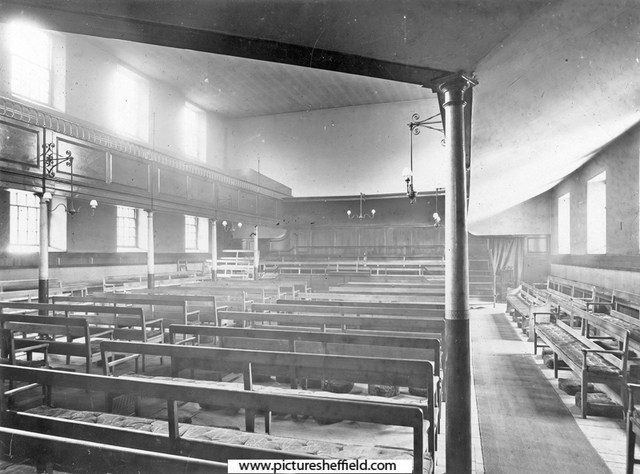
Interior of Friend's Meeting House, Hartshead. 1905.s05100 Friends' Meeting House, Hartshead after air raids. December 1940. https://www.picturesheffield.com/frontend.php?keywords=Ref_No_increment;EQUALS;s01202&pos=15&action=zoom&id=5060 Can anybody help with an image of the Friends Meeting House before 1940. Construction of "New" Friends Meeting House, Hartshead. 30th January 1964. https://www.picturesheffield.com/frontend.php?keywords=Ref_No_increment;EQUALS;s33106&pos=12&action=zoom&id=67278 Friends Meeting House, Hartshead. 1966. u11714 Is there a photograph of the Interior of this building? Friends Meeting House, corner of Vicar Lane and St. James Street. April 1991. https://www.picturesheffield.com/frontend.php?keywords=Ref_No_increment;EQUALS;s33107&pos=10&action=zoom&id=67279 Interior of Quaker Meeting House, St. James Street. 2015. https://www.picturesheffield.com/frontend.php?keywords=Ref_No_increment;EQUALS;arc01518&pos=2&action=zoom&id=66810 Plan of The [Quaker] Meeting House and burial ground, [1701] https://www.picturesheffield.com/frontend.php?keywords=Ref_No_increment;EQUALS;arc03652&pos=21&action=zoom&id=99202 Plan of The [Quaker] Meeting House and burying ground, and the widening of Meetinghouse Lane, [c. 1796-1801] https://www.picturesheffield.com/frontend.php?keywords=Ref_No_increment;EQUALS;arc03653&pos=22&action=zoom&id=99203 Plan of The [Quaker] Meeting House and burying ground, and the widening of Meetinghouse Lane, [c. 1796-1801] https://www.picturesheffield.com/frontend.php?keywords=Ref_No_increment;EQUALS;arc03654&pos=23&action=zoom&id=99204 Were the bodies reinterred?
-
Ordnance Survey Map, Yorkshire No. 294.3.24 (black and white). 1889. https://www.picturesheffield.com/frontend.php?keywords=Ref_No_increment;EQUALS;q00035&pos=6&action=zoom&id=71863 The remaining part of the old Barracks, the "Infirmary" at the junction of Penistone Road/Barrack Lane backing onto Thirza Street is shown as "Don View." The Old Barrack Tavern (the first one, as opposed to the Barrack Tavern near the Hillsborough Barracks) at the junction of Penistone Road and Balaclava Road (1889 Map), does any body know when it was built? There is a building (1850 map) with a bowling green, wondered if this became the Old Barrack Tavern. 1850 OS Map. https://maps.nls.uk/view/102345217#zoom=7&lat=8185&lon=9916&layers=BT
-
1795 Fairbanks Plan of the Barracks https://www.picturesheffield.com/frontend.php?keywords=Ref_No_increment;EQUALS;arc02713&pos=13&action=zoom&id=91680 It appears the old Barracks building which originally fronted onto Whitehouse Lane had already been demolished by the aerial image of 1938 to improve the Infirmary Road/Langsett Road; that would I think be the one possibiy depicted in the painting. Thanks for sourcing the aerial shot. On reflection wouldn't the old Barracks have been demolished by this time?
-
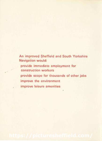
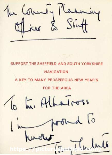
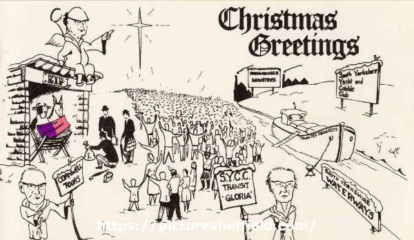
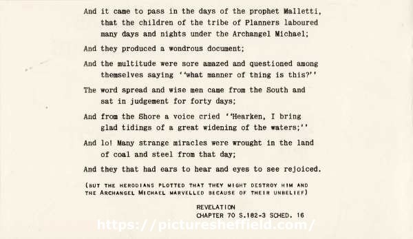
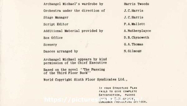
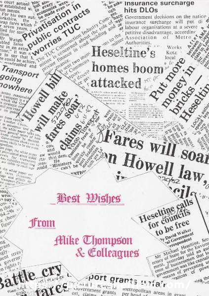
South Yorkshire County Council Christmas Cards. South Yorkshire County Council Christmas Card - South Yorkshire Waterways. arc07248arc7249arc07250 An improved Sheffield and South Yorkshire Navigation would: Provide immediate employment forconstruction workers Provide scope for thousands of other jobs Improve the environment Improve leisure amenities Support the Sheffield and South Yorkshire Navigation - A key to many prosperous New Year’s for the area. Original at Sheffield City Archives: SYCC/PL/31/13 (altrefno: SYCC CB 681). South Yorkshire County Council Christmas Card - South Yorkshire Waterways / County Structure Plan. arc07245arc07246arc07247 Includes reference to Thwaites Progress (Roy Thwaites was Deputy Leader of the County Council, 1979-1980 and Leader, 1980-1986), Cornwell Tours (John Cornwell was Deputy Leader, 1981-1986), SYCC Transit 'Gloria', South Yorkshire Yacht and Cobble Club, EIP, and (inside the stable) Structure Plan Written Statement. And it came to pass in the days of the prophet Malletti, That the children of the tribe of Planners laboured Many days and nights under the Archangel Michael; And they produced a wondrous document; And the multitude were sore amazed and questioned among themselves saying ''What manner of thing is this?'' The word spread and wise men came from the South and sat in judgement for forty days; And from the Shore a voice cried ''Hearken, I bring glad tidings of A great widening of the waters;'' And lo! Many strange miracles were wrought in the land of coal and steel from that day; And they that had ears to hear and eyes to see rejoiced. (But the Herodians plotted that they might destroy him and the archangel Michael marvelled because of their unbelief) Revelation chapter 70 s.182-3 sched 16. Archangel Michael's wardrobe by Harris Tweeds Orchestra under the direction of J. C. Harris Stage Manager J.C. Harris. Script Editor F. A. Mallett. Additional Material provided by A. Nutherplayce. Box Office D. B. Chynoweth. Scenery G. A. Thomas. Dances arranged by N. Gilmour. Archangel Michael appears by kind permission of the Chief Executive. Based on the novel '"The Passing of the Third Floor Buck". World Copyright Sixth Floor Syndicates Ltd. If your structure plan fails to give complete satisfaction, please write to S. Gascoigne, Consumer Protection Officer. Original at Sheffield City Archives: SYCC/PL/31/13 (altrefno: SYCC CB 681) South Yorkshire County Council Christmas Card - best wishes from Mike Thompson and Colleagues. arc07243 Original at Sheffield City Archives: SYCC/PL/31/13 (altrefno: SYCC CB 681) arc07244 This card depicts the Prime Minister, Margaret Thatcher, and the Secretary of State for the Environment, Michael Heseltine, carving up a Local Government Pudding. This related to the Government's plans to abolish Metropolitan County Councils in 1986. Original at Sheffield City Archives: SYCC/PL/31/13 (altrefno: SYCC CB 681). South Yorkshire County Council - final Christmas Card. 1985.arc05252 Image from Sheffield Local Studies Library: MP Folder 2.


-

Dixon Lane in Sheffield City Centre
boginspro replied to Sheffield History's topic in Sheffield History Chat
Great photograph but like many images on Picture Sheffield this is wrongly titled. It is actually Broad Street with the Rag an' Tag, (old Sheaf Market) on the right. Dixon Lane ended at the Norfolk Arms. -
Dixon Lane in Sheffield City Centre
Ponytail replied to Sheffield History's topic in Sheffield History Chat
Shame this photograph isn't in colour. Rock Tavern, No. 20 Dixon Lane, 1969. s21769 From: https://www.closedpubs.co.uk The Lost Pubs Project. Rock Tavern. https://www.closedpubs.co.uk/yorkshire/sheffield_s1_rock.html Pub History.com Rock, 20 Dixon Lane. https://pubshistory.com/Yorkshire/SheffieldR/RockDixon.shtml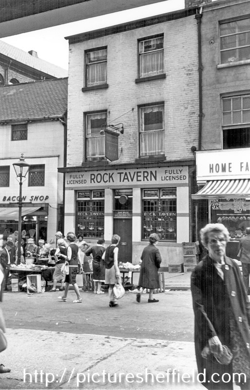
-
Dixon Lane in Sheffield City Centre
Ponytail replied to Sheffield History's topic in Sheffield History Chat
Norfolk Market Hall, Haymarket, before 1896, showing the old west front which was rebuilt 1904-5. Tontine Commercial Hotel on corner of Dixon Lane in background. https://www.picturesheffield.com/frontend.php?keywords=Ref_No_increment;EQUALS;s00297&pos=4&action=zoom&id=4285 This is the best image I can find of the Tontine Commercial Hotel. A search of the Directories would be needed to determine how long it was in existence. Just my opinion but probably named in homage to the old Tontine Coaching Inn. -

Dixon Lane in Sheffield City Centre
southside replied to Sheffield History's topic in Sheffield History Chat
This 1890 map from Picture Sheffield shows a Tontine Hotel located at the top of Dixon Lane, was this in any way connected to the Tontine Inn demolished in 1850 to make way for the building of the new Norfolk Market Hall? https://www.picturesheffield.com/frontend.php?action=printdetails&keywords=Ref_No_increment;EQUALS;q00081&prevUrl=