Search the Community
Showing results for 'coal pit lane'.
-

Seeking information on the Vickers family of Sheffield
Meg Young posted a topic in Sheffield History Chat
I am new to this forum and have not been successful in my search for this topic in your files. I apologize if I am bringing up an old topic. I am seeking information on Benjamin Vickers, Master Cutler of 1799. I tried doing a search on your site for Benjamin Vickers, Master Cutler, 1799, but got nothing. In Robert Eadon Leader's "Reminiscences of Old Sheffield," there is a mention of Benjamin Vickers on p. 141, "Between Hicks lane and Workhouse lane was Mr. Benjamin Vickers, who was Master Cutler in 1799. He was uncle to the then Mr. Vickers of Mill Sands and granduncle to the late (1872-73) Master Cutler, Mr. T.E. Vickers." Mr. John Vickers, corn miller of Mill Sands, is my 3rd ggrandfather. His 5th son, Henry Vickers, who became a solicitor in Sheffield, is my 2nd ggrandfather. I am having great difficulty discovering who the parents of John Vickers were. I've been in on-line contact with two descendants of Edward Vickers, Henry's older brother, on Ancestry.com, and they don't know either. There are Vickers trees on Ancestry, but they have little documentation and I don't trust them. I'm hoping that information on Benjamin Vickers Master Cutler 1799, will throw light on the parentage of John Vickers as Benjamin's brother would have been John Vickers' father. On Ancestry I have found various documents with the name Benjamin Vickers. On Church Lane listed under Cutlers Company is a Benj. Vickers, proprietor, from 1781 (land tax documents). On Spring Croft there is a Benjamin Vickers, silversmith, who is paying tax on apprenticeship dues received in 1786, etc.. In 1817, there is an entry in Quarter Session Records, Wakefield, regarding a James Robinson's theft of blades, steel, and ivory from Francis Carr, Benjamin Vickers, and William Anderson. Are these Benjamin Vickers all the same man, or different men? I am showing my ignorance, but were cutlers ever silversmiths? Did people have workshops on different streets in the town? I've looked for a map of 1799 to find Hicks lane and Workhouse lane to see if Church lane or Spring croft are near by but haven't been able to find a map. Can anybody help me out? Yours in ignorance. -
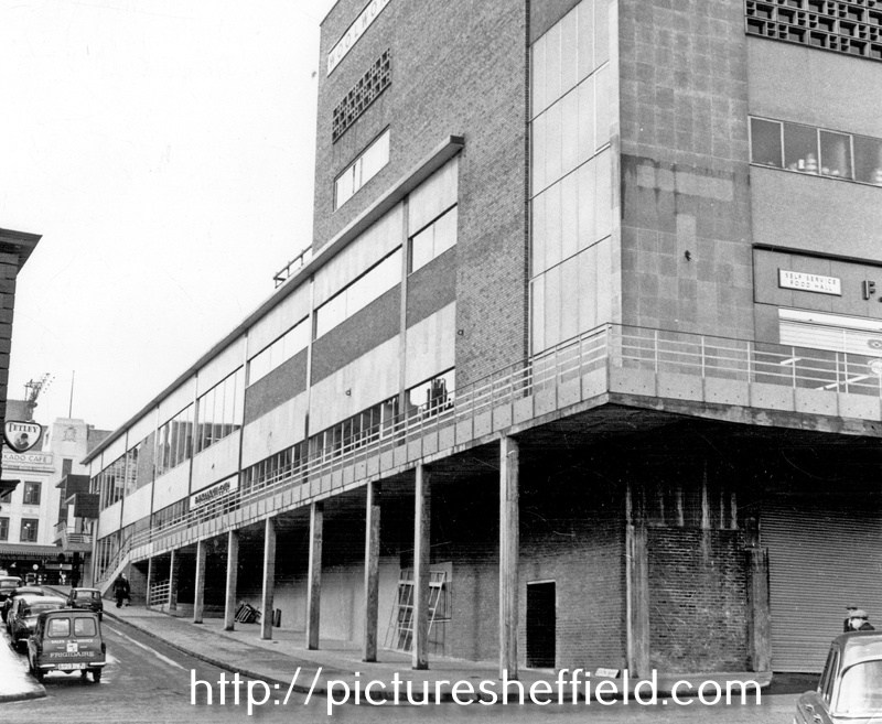
Dixon Lane in Sheffield City Centre
Ponytail replied to Sheffield History's topic in Sheffield History Chat
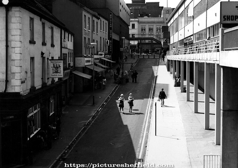
Junction of (foreground) Haymarket and (centre) Dixon Lane. 1960's p01431 This image was originally part of the Tim Hale Photographic Collection. It was purchased at auction in September 2019 through donations from members of the public and a grant from the Graves Trust. Corner of Dixon Lane and Haymarket (before the construction of F. W. Woolworth's) c.1959 s37986 Dixon Lane from Haymarket, after the demolition of Norfolk Market Hall. 1959.s14912 Dixon Lane, June 1952, from Haymarket, Norfolk Market Hall on the left, demolished 1959. s00327 Norfolk Market Hall and Castlefolds Market, Exchange Street on Ordnance Survey map, showing Dixon Lane. 1890. https://www.picturesheffield.com/frontend.php?keywords=Ref_No_increment;EQUALS;y06786&pos=87&action=zoom&id=59990
-
Dixon Lane in Sheffield City Centre
Ponytail replied to Sheffield History's topic in Sheffield History Chat
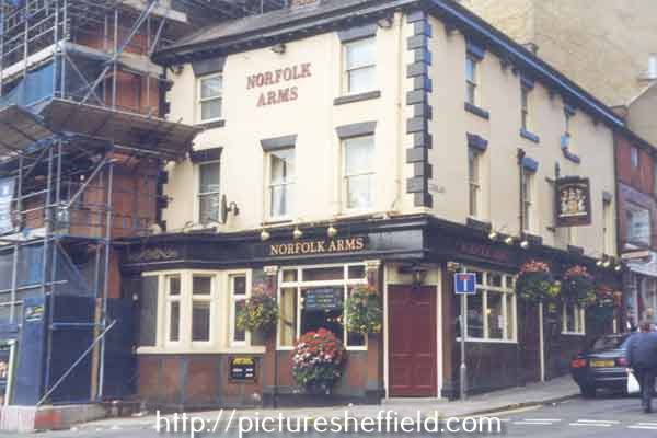
Dixon Lane, (l. to r.) No. 26, Norfolk Arms, No. 24, T. Bates (Wallpapers) Ltd., paint merchants, No. 22 and 16a, William John King Ltd., provision dealers, No. 20, Rock Tavern, No.18, Dixon Meat Stores. s21768 Norfolk Arms public house, No. 26 Dixon Lane. August 1999.v04579 Dixon Lane (l. to r.) No. 20 Dewhurst, butchers; No. 18 Kings, delicatessen, No.16 Thurston's bakers; No.14 Thresher Drinks Store and side entrance to British Home Stores. https://www.picturesheffield.com/frontend.php?keywords=Ref_No_increment;EQUALS;t14010&pos=56&action=zoom&id=151404 Dixon Lane and Castlefolds, F. W. Woolworths and Co. Ltd., right. 29th March 1962. s14903 Photographer: City Engineers Dept. Dixon Lane looking towards Haymarket, including No 26, Norfolk Arms public house, and British Home Stores, left; F.W. Woolworth and Co, right. 19th May 1975. s00174 Photographer: City Engineer and Surveyors 24122/2.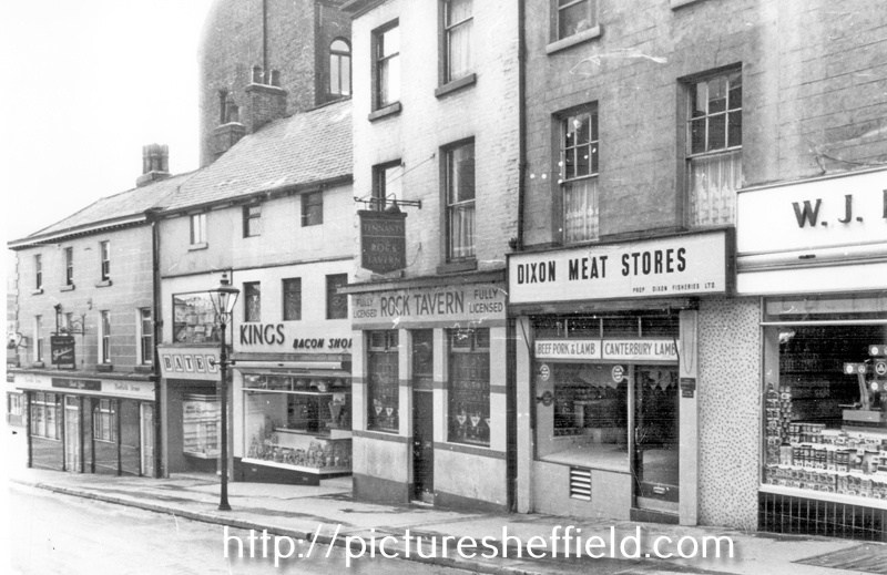
-
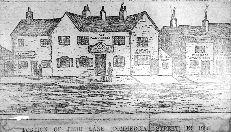
The character's in this fictional tour of our lost pubs are from my own imagination apart from the names of the pubs mentioned and its licencees. “Dus`t Tha` Fancy A Pint?” Hello again, well the time has soon past since our last jaunt through the lost pubs of old Sheffield Town, our crawl today centres around Fitzalan Square, you’ll be surprised just how many pubs were around this area. Our time machine is set for 1856, a bit further back than usual but why not. Just an hour ago I summoned a cab to go to the Workhouse to pick up my two pauper friends, Mr Dawson & Mr Sorsby, the cab has cost me half a crown but they are worth it. As they arrive, they are excited little tinkers and we enter the Golden Ball at No 12 Forge Lane, in 1872 this lane was renamed Shude Lane, this old pub was open in 1796 and at the time of our visit, according to my Whites 1856 Directory the landlord was Samuel Walker, this pub reflects the area and the times we are in, sawdust on the floor, a hotch-potch of customers some are on the point of drunkeness, the Sheffield twang at this time has to be really listened to be understood, my two friends think its Polish! Leaving the Golden Ball we just cross over Forge Lane and enter the Golden Lion at No 3, the Golden Lion was the heraldic sign of King Henry Ist and the Percy family who were the Dukes of Northumberland, at this period of time its surprising just how many ordinary townsfolk are quite knowledgeable on the heraldic signs of the gentry, anyway our landlord is John Staniforth and he keeps good order in the pub, this pub was built in or around 1822 and like the Ball they were swept away around 1879, after that year I cant find any entry’s in my later directories for these two pubs. On leaving here we walk up Forge Lane a few yards and turn to our right into Shude Hill (Shude comes from a word meaning barley husks) and visit the Old English Gentleman at No 12, not named after me I may add, this is another old pub, it was open in1796 and by 1917 it had gone, the present licencee is George Wilkinson, a stocky man who keeps a very good pint and like the others in our crawl the pubs are very basic, sawdust, spittoons etc. Are the order of the day, but the brass is gleaming in the gaslight. Wiping the froth of my top lip, we are off to our next port of call which is the Little Barrel, as we leave the Gentleman we turn left walk up the road and the Barrel is on our left at No 40 Little Pond Street, our host is Albert Humphrey, a very jovial man who greets every customer as he has known them for years, most of which he has, this little pub had a licence in 1818 and again after 1879 I cant find no record of this pub, one thing you notice about the beers in these pubs the difference in tastes, its quite refreshing. On leaving the Barrel we cross over the street and enter The Rose at No 29, I cant find any info on this little pub but I can find an entry as a beerhouse at No 29 and it was run by Elizabeth Cole, so less said the better on this little watering hole, if anyone has any information on this elusive pub I would love to have it. Our next pub is The Tankard at No 27,its licence is held by Mr Thomas Booth, we are still on Little Pond Street on the right hand side of the road, its now getting pretty busy on here you cant believe the numbers of carts being pulled by great big horses, it’s a very crowded on the pavements too with children and mothers looking for husbands so they can get some money from them before its drank away, the Tankard was spanking new in 1825 and by the late 1870s it had ceased to be, redevelopment for the General Post Office. We leave the Tankard, trying not to bump into any of the crowds, keep to our right and the Beehive comes into view at No 13, in 1856 its classed as a beerhouse, so it must have acquired its name a few years later and by the turn of the century or later it had been demolished for the Post Office to be built, on our visit the master of the hostelry is Henry Johnson who exudes authority my two poorhouse plebs will not look him in the eye. Finishing our half’s of best ale we bid adieu to the customers and leave to go to No 1 which is the address of the Black Swan Hotel describes as a wine & spirit vaults, the landlord is a Mr John Slingsby, this pub is one of the most frequented on Little Pond Street and you can understand why, clean glasses, clean brass-work, no broken gas mantles if fact its quite the bees knees. This is the last pub on Little Pond Street, from here we turn right at the side of the pub and head for Sycamore Street just a hop, step and a jump away and we find The Prince Of Wales at No 38, the landlord is a very friendly Irishman called Daniel O’Donohoe, a man full of stories of the old country, he certainly kissed the blarney stone, we could spent more time in here drinking his porter but we press on, not before visiting the back to ease ourselves. On leaving we have to be extra vigilant as the strong beer is taking us over and we wouldn’t want to knocked over by a carrier and fall in the horse droppings, we walk directly to Flat Street cross over to the right-hand side of the street and enter No 13 which is The Falcon Inn, easing the thirst of the thirst of the hard working men and women of the town from 1825 but it was swept away by the building of the G.P.O., our landlord is Bernard Isele, strange name and a demeanour to match, “nowt as strange as folk“, the falcon was the favoured choice of hunting bird by the kings & queens of England for centuries Queen Elizabeth had one incorporated to her coat of arms. We leave the Falcon and even though there’s a pub just across the road we prefer to leave that one for a while and return later, we keep on the right and at the corner we go down Bakers Hill to the Palace Inn at No 6, the chap holding the licence is John Ibbotson, this dirty little pub was open around 1833 and this one suffered the same fate but It wasn’t the Post Office that took the site as in 1879 a Mr John Cowlishaw & son had moved into the premises and they were Pearl Handle and Cutlery Merchants, so the Palace Inn had a very short life. Bakers Hill as the name implies, was the site of the Town bakehouse where for a few pennies you could bring your dough and have it baked into loaves, the hill also held bread shops, up to 1849, Bakers Hill wasn’t the one we see today it actually ran to the bottom of Norfolk Street, Mr William Barker seems to have been the last baker in Bakers Hill, it was on Bakers Hill where Redgates had a works making Perambulators. On leaving the Palace we cross over the road and go in the Three Horseshoe's at No 92, Norfolk Street but when looking at the map it confirms that Bakers Hill but there you go, this pub was open in the early 1800s but Mr Schicklgruber had one of his Junkers bombers wipe it out in 1940, were surprised to find our host is a lady, Elizabeth Wheeldon, it would have been nice for this old pub to have survived but it wasn’t meant to be, we bid goodbye to Elizabeth and head for Jehu Lane, we walk up to our right and on to the lane to seek the Blue Bell at No 13, the licencee is Thomas Colley but he’s not in when we call, lots of people seem to think Jehu Lane is a corruption of Jew Lane which it isn’t, in A Description Of The Town Of Sheffield written in 1832 by Joseph Woolhouse, he writes “ Jehu Lane was always a very narrow, dirty street. The reason as I have read of the name of Jehu being given to this lane was when Mary Queen of Scots was going to the Castle from the Manor Lodge through this lane was then the road. The Coachman in driving thro` this lane used to this expression to his horses “Jehu! Jehu!” and to this day it continues to be called that”, you have to keep in mind this area was much steeper than it is today and I also suspect the “Coachman may have shouted “Jee-up” which eventually became Jehu. I don’t think this explanation is true as the easiest route to The Manor Lodge for Mary Queen of Scott’s would have been down Dixon Lane and over the bridge and on up to the Manor Lodge, perhaps it was the carters plying their trade that gave Jehu Lane its name by urging the horses to “Gee-Up” Leaving the Blue Bell, we turn right and walk further on Jehu Lane to the Nags Head, this pub can be traced back to 1790 and was demolished around the 1890s, William Topham is the landlord and the pub is very busy because of the Market which stands a few yards away on Market Place and King Street, the Nags seems to have a couple of addresses, besides Jehu Lane its mentioned as Nags Head Yard and Haymarket, its advertised as Nags Head & Billiard Rooms, we’ve no chance of a game, to many waiting, after a swift tankard we leave and walk across Jehu Lane to the Bricklayers Arms at No 8 Jehu lane, this is another old 18th century pub mentioned in records in the1790s, again its packed and you get a few weird smells as the slaughterhouse workers pop in for a pint, this pub like them all on Jehu Lane was swept away when Fitzallan Square was developed in 1893, Jew Lane was what you see now, it was a passageway to the rear of properties on Jehu Lane. Leaving the Bricklayers we walk across the spare ground towards The Bell, on Market Street, again another old pub serving the folk of the town in 1796, The licencee is Mrs Fanny Berry, in around the late 1880s this pub was closed and after the new square was developed its licence was transferred to the new Bell where you see it today. Market Street was where the White Building and the old Marples stand, on leaving the Bell we cross over Market Street to the Cup at No 7, the landlord is Mr John Fisher, this pub was open for business in 1825 and by the 1870s it was closed as in 1879 Nurseryman Fisher & Son were running their business from this address, in the 17080s roughly parallel with Mulberry Street stood the slaughter houses and the from where Change Alley finished down to the end of Commercial St this area was called the Swine Market, all gone now, on leaving the Cup we turn to our right and skip a few yards to The Star Inn at No 2 Market Street, information on this pub is very sparse even going back to 1833, so it could be it was built in the 18th century and eventually became a wine & spirits merchants property, but at the address, No 2, I can find a John Marples Wine & Spirit Merchant, he was the first owner of The Market Street Wine Vaults in 1888 and the licencee was Edward Marples so you can understand why it was nicknamed “Marples”, I’ve omitted this pub from our crawl as it wasn’t built in 1856. Moving on we leave and enter The Elephant Vaults at No 2 Norfolk Street, our landlord is George Parvin, a previous landlord Mr Thomas Bell was a coachman and guard on the Sheffield to Louth mailcoach, it was in this lovely old pub where I met my wife Mary in 1964, Aah happy days, it was open in 1818 and was closed in in the late 1960s and a Halfords car spares shop was built in its place. After leaving this temple of love we cross Norfolk Street to No 3 Norfolk street where the Ball Inn stands, this is another pub that’s hard to research, it was in business in 133 and by the 1860s it was used by Robert Taylor as a Hairdressers, Taylor & Taylor ancestor? We leave the Ball turn to our left and enter No 5 where the Norfolk Arms sits, again this pub is very busy, full of customers who are full of the falling down water, there’s a raucous commotion in the snug where two women are having an altercation, our licencee is Mrs Hannah Blake and she’s quick to eject the two ladies, this pub was open in 1825 and it had gone by 1879, we drink up and leave to go to our next port of call which is The Cross Daggers which is on Cross Daggers yard, just few yards back down Norfolk Street on the right hand side, this yard was also known as the fruit market, in the 18th century Anne Asline owned the pub, by 1791 Robert Sandy held the deeds, in 1829 Richard Greenwood had it and by the early 1840s it was closed as a pub and became a warehouse. We leave the site of the Daggers, no drink here, we walk back to Norfolk Street turn right and up to No 16 Norfolk Street where we find the King And Miller, it was selling beer in 1816 and by 1893 Staines & Evans Wool Merchants were using the premises, our landlord at the time of our visit is George Goodwin, another great old pub, sawdust, gas lights perfect, We leave the King and Miller and walk on Change Alley towards the site of what will be the Mitre that will stand here in 1871, we cross over Change Alley to our last call and its at the Kings Head Hotel that has the No 3 - No13, its described as a family and commercial hotel and restaurant, this hotel was claimed to go back to 1542 and it was bombed in the Blitz, makes a change from the council destroying our old buildings. This is where novelist Charles Dickens stayed on his visits to the town. Well that’s it my friends another fine walk into our rich history, just remember where ever you walk the history of the city is just beneath your feet. We will return to Norfolk Street next time, cheers. The multi coloured building shown on High street maybe the Grey Horse, it might even been the Blackamoors Head, Confirmation needed.


-
S. Newbould’s premises on Little Sheffield Moor, and John Taylor’s house, 1787. https://www.picturesheffield.com/frontend.php?keywords=Ref_No_increment;EQUALS;arc03771&pos=28&action=zoom&id=99407 Land purchased of the Duke of Norfolk by Samuel Newbould and Thomas Holy at Little Sheffield. 1803. https://www.picturesheffield.com/frontend.php?keywords=Ref_No_increment;EQUALS;arc04083&pos=7&action=zoom&id=72460 Several fields between Broom Hall Lane and The Moor, across which Clarence Street was afterwards made. The line is indicated on this plan. Shows Broomhall Lane, Younge Street and Samuel Newbould’s property. William brother of Samuel Newbould. (Information from Grace's Guide, "The second son William (1749-1802) married Sarah, daughter of Thomas Holy, button manufacturer, and was in partnership with his father-in-law.") Ground on Little Sheffield Moor demised by the Marquis of Rockingham to T Holy and William Newbould, 1776. https://www.picturesheffield.com/frontend.php?keywords=Ref_No_increment;EQUALS;arc03770&pos=27&action=zoom&id=99406 House, workshops, erected on the leasehold ground of Thomas Holy and William Newbould, [The Moor], 1790. https://www.picturesheffield.com/frontend.php?keywords=Ref_No_increment;EQUALS;arc04259&pos=23&action=zoom&id=34922 Marked: William Newbould, T. Holy's house, warehouse, etc. (Information from Grace's Guide "The Newboulds were tilting at Loxley. Miller remarked: “Old Wheel Dam . . . would seem to have run both a tilt and a grinding wheel in the early part of the nineteenth century, when for seventy or eighty years, the property was owned by the Newboulds. Messrs. Samuel Newbould and Co. were tilters here for a considerable period but the Dentons leased the forge from somewhere about 1845 to 1885.”) Plan of an Estate situated at the Old Wheel in the Parish of Bradfield the property of S Newbould. 1820. https://www.picturesheffield.com/frontend.php?keywords=Ref_No_increment;EQUALS;y09601&pos=4&action=zoom&id=3529 Plan of land at Loxley intended to be sold to Samuel Newbould (part between Old Wheel Dam and Storrs Wheel), by W. and J. Fairbank. 1825. https://www.picturesheffield.com/frontend.php?keywords=Ref_No_increment;EQUALS;y09598&pos=6&action=zoom&id=44514
-
Maps of the Parish of Handsworth, based on the Enclosure Award Maps (1805) and corrected up to 1855.
Ponytail replied to Ponytail's topic in Sheffield Maps
Map of Woodhouse Junction area, c.1855. https://www.picturesheffield.com/frontend.php?keywords=Ref_No_increment;EQUALS;arc02940&pos=1&action=zoom&id=93148 Includes: Green Gate Lane; Birley Vale Branch Railway, Beighton Branch Railway, Manchester Sheffield and Lincolnshire Railway; River Rother; Woodhouse Colliery; Woodhouse Mills; Shirecliffe Brook; Cinderhill Green Road; Furnace Lane, Woodhouse Junction Station; Shaft. From a volume of Maps of the Parish of Handsworth, based on the Enclosure Award Maps (1805) and corrected up to 1855. Dimensions of original: 34 x 51cm. Original at Sheffield City Archives: CA369/1. -
Tapton Hall, Shore Lane showing extension built 1968 by Hadfield, Cawkwell and Davidson. October 1988. s29369 s29367
-
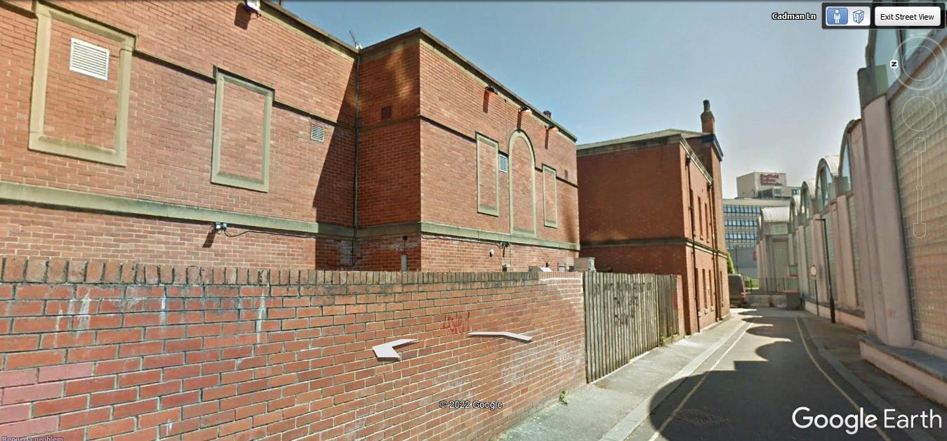
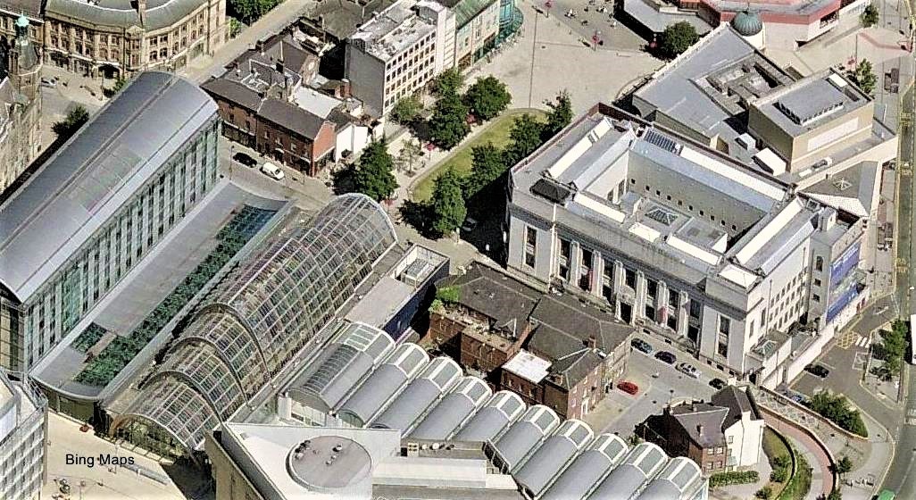
Thought i`d have a look on Google Earth at the exact location of Cadman Street to get an idea of the area in tozzins enquiry! by mistake i searched Cadman Lane, which took me to the lane behind the Graduate Pub on Surrey Street, i was intrigued by the brickwork on the rear of the pub, can anyone tell me if this is an extension to the building or is it part of the original building? A couple of photographs, one from Google Earth showing the brickwork and one from Bing Maps showing the buildings location.
-
Plan of Land near Portobello agreed to be leased by Benjamin Withers to Samuel Sharman and others. 1835. https://www.picturesheffield.com/frontend.php?keywords=Ref_No_increment;EQUALS;arc03848&pos=38&action=zoom&id=99542 Marked: Glossop Road; Withers Street; Withers Lane; Cavendish Street.
-
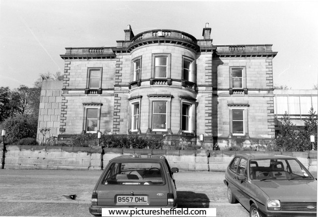
Any info on the house or the gate house please ? I know it was a Naval Cadette training base , where has the old boforse gun gone?, but has it past naval links,who built it and when ? Also the playing fields in front of it , what are they built on i.e. gardens or the remains of mine workings, as I have seen large issues of water spring up from the bank sides in front of the old wood at the side,after very heavy rain fall.
-
Plan of a projected street between Queen Street and West Bar Green. 1817. https://www.picturesheffield.com/frontend.php?keywords=Ref_No_increment;EQUALS;arc04217&pos=13&action=zoom&id=105201 Marked: Tenter Street, Pea Croft, West Bar Green, Silver Street, Paradise Square, Workhouse Croft, Queen Street, workhouse, reservoir, fitting up shop, boring mill, Foundry, warehouses, smiths shops, fetling shop [?fettling shop], counting house, lumber house and model chambers, engine house. Tenants / owners: John Haslehurst, W. B. Thomas, John Clayton, Joseph Whitehead, Samiel Eadon, Robert Burnand, S. B. Ward, George Smith, - Eyre, Charles Rhodes coopers shops, John White, John Darwin, Benjamin Hounswind?, John Sevrap?, and Edward Gains. Town land, extending from Broad Lane End to West Bar, 1778. https://www.picturesheffield.com/frontend.php?keywords=Ref_No_increment;EQUALS;arc04287&pos=18&action=zoom&id=105972 The plan has notes made in 1784. Marked Broad Lane End, Hollis Croft, Rotten Row, West Bar Green, Pea Croft, White Croft, Hawley Croft, Gregory Row, Silver Street, Hick Stile Field, Queen Street, Workhouse Croft, and Workhouse. George Hounsfield, Samuel Radford, John Birks, George Allen, George Oates, John Haywood, Hollis Hospital land, Thomas Wilkinson, Josh. Bower of Hollis Hospital, Martha Hill, John Foster, William Thornton, John Thompson, Matthew Lambert, John Goodwin, Ebenezer Wall, George Greaves, Thomas Radford, Joseph Hepworth, Mary Cowley, Samuel Crook, Widow Bradshaw, George Pears, John Holberry?, Catherine Dixon, Mark Skeltens?, John Hobson, Stephen Green, John and George Wild, [?] Green, The Overseers of the Poor in the Township of Ecclesfield, Ecclesfield Workhouse [tenants of this parcel of land], John Longden, Mary Pearson, John Darwin and Co., and Samuel Marshall.
-
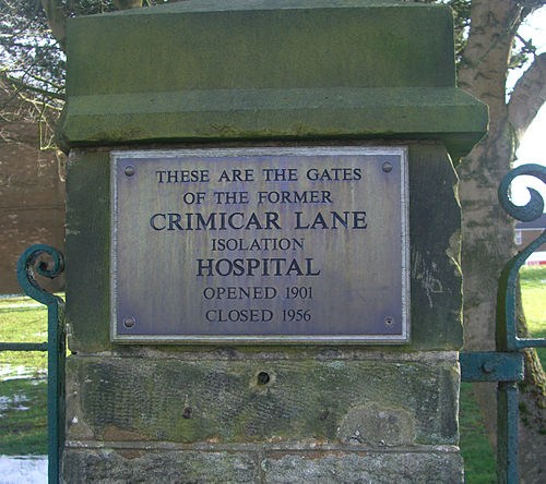
Copied from Wikipedia. "In 1955 the Board recommended that Crimicar Lane should no longer be used as a hospital and the tuberculosis Huts were demolished at that time.[2] All patients were transferred to Lodge Moor Hospital on 31 May 1956.[1] The hospital stood empty for some time before the remaining buildings were demolished to make way for the housing which now stands on Westminster Crescent. All that remains of the old hospital are the perimeter wall and the main gates which have a memorial plaque attached to them.[1]" Full Wikipedia: https://en.m.wikipedia.org/wiki/Crimicar_Lane_Hospital Crimicar Lane Hospital, Sheffield https://discovery.nationalarchives.gov.uk/details/r/2fecb3e5-bc53-4b16-96d4-5df8d95893df Including Information: Crimicar Lane Hospital and Sanatorium was opened in November 1902 for the reception of smallpox cases. It consisted of two wards, each accommodating 21 beds; an isolation block accommodating four wards each with two beds; also an administrative block, laundry and disinfector. Prior to the First World War the hospital was primarily for cases of smallpox, but consumptive (tuberculosis) patients were admitted if smallpox cases were lacking. In 1915 a temporary wooden ward was erected to accommodate 48 patients and an extension to the administrative block was built in 1916. Many patients were those associated with the cutlery industry: grindstones and buffing wheels created a huge amount of gritty dust. Silicosis was the cause of great mortality, as was tuberculosis which was often associated with the "dolly polishing" of silverware. In 1950 the hospital had accommodation for 53 patients. In 1955 the Planning Committee of Sheffield Regional Hospital Board recommended that the use of the premises as a hospital be discontinued and that the patients be moved to Lodge Moor Hospital. The buildings were to be retained pending instructions from the Ministry of Health. The patients were all transferred out of the hospital on 31 May 1956; the patients at Commonside Sanatorium also being transferred to Lodge Moor at around the same time. The hospital buildings were later demolished to make way for housing; all that remains are the part of the perimeter wall and gates (2004). Administration The hospital was administered by Hospitals Committee of Sheffield City Council, established under the Public Health Act, 1875. In 1927 this committee became a sub-committee of the Health Committee. At the establishment of the National Health Service in 1948 management, like other hospitals formerly administered by the Council, passed to the Sheffield No 3 Hospital Management Committee of Sheffield Regional Hospital Board (SRHB).
-
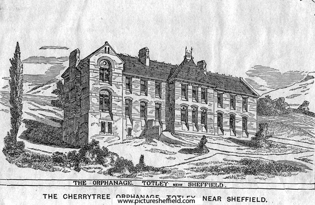
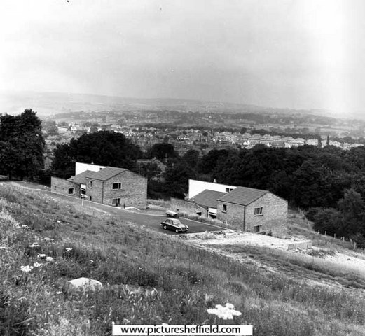
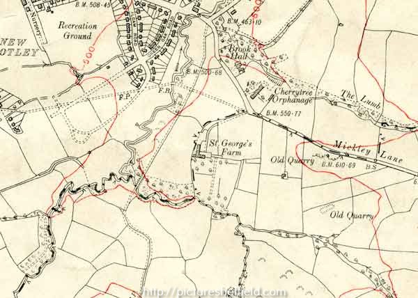
Cherrytree Orphanage, Mickley Lane, Totley. Founded in Sheffield about 1863 by E.P. Taylor, Esq. Foundation stone laid 21st August, 1867 by John Webster Esq., Mayor of Sheffield. Total cost £4,000. 1872. s07784 Picture taken from the 8th report, 1872. In 1868, Mr Taylor, transferred the property to trustees. The institution, which was supported by voluntary subscriptions and a Goverment grant, had for its objects the boarding, clothing, and education of poor children who had been deprived of both their parents, irrespective of religious belief ot nationality. Miss Stronach was matron in 1906. Cherrytree Orphanage, Mickley Lane, Totley. 1963. https://www.picturesheffield.com/frontend.php?keywords=Ref_No_increment;EQUALS;s35076&pos=2&action=zoom&id=70519 Cherrytree Homes, Mickley Laneu06868 Buildings used to house 1 carer and around 6 children, built around 1969. Once completed the original Cherrytree orphanage was subsequently turned into an old peoples home (Information care of Sharon Parkinson). Presentation to Cherrytree Orphanage, Mickley Lane. 14th February 1967. https://www.picturesheffield.com/frontend.php?keywords=Ref_No_increment;EQUALS;s07784&pos=5&action=zoom&id=11019 OS Map dated 1935, showing Cherrytree Orphanage & St George's Farm, one time home of John Ruskin. y12786
-
Plan of Thomas Rawson and Co., Pond Street Brewery, c. 1832. https://www.picturesheffield.com/frontend.php?keywords=Ref_No_increment;EQUALS;arc04208&pos=22&action=zoom&id=105173 Marked: Pond Street, Arundel Lane, houses, malt houses, joiners shops, stables, shed, coopers shops, scalding room, malt warehouse with vat houses under, drying kilns, boilers, engine house, coat yard, brew house, dwelling house, kitchen, counting house, Harmers open [presumably Harmer Lane]. Owners / occupiers marked: Septimus Priestley and Joseph Levick. Shows progression of plan https://www.picturesheffield.com/frontend.php?keywords=Ref_No_increment;EQUALS;arc04206&pos=20&action=zoom&id=105169
-
Beginnings of Sheffield Water Works. Extracts from Reminiscences of old Sheffield, its streets and it's people. Edited by Robert Eadon Leader 1875 from articles and letters from the Sheffield and Rotherham Independent 1872/3. Page 42. Twiss: The original water-house of the Water Company is still standing, at the sharp angle between Pinfold Street and Campo Lane. It has just come into the possession of the Town Trustees, and will doubtless soon be sacrificed on the altar of street improvements. A comparison of this with the present handsome premises of the Company, in Barker Pool, exhibits very strikingly the contrast between the old order of things and the new. Leighton: In the angular space at the top of Townhead street, formed by the meeting of Church Street, Bow Street, Pinfold Street, and Townhead Street, stood formerly the Townhead cross. None of us can remember it — I doubt whether any of us know when it disappeared, or whither it went; but that is no reason for passing it by without notice. Twiss: The premises at the top of Townhead Street now occupied by Mr. Jackson, pork-butcher, have a history. Here resided, more than a century ago, Mr. Matthewman, who was one of the originators of the Water Company. In 1744, he and Mr. Battie succeeded to the powers granted in 1713 to Messrs. Goodwin and Littlewood by the Lord of the Manor, and constructed the first works at Crookes moor. He was the maternal grandfather of Mr. Albert Smith. Everard: This house was occupied for some years by Mr. Moorhouse, surgeon, who got killed by a fall from his horse. On his decease, Mr. James Kay, who had served his time with him, purchased the business of the widow; and, after living and carrying on his profession on the premises for a considerable period, he built and removed to the house in Victoria street, Glossop road. At the time it was generally thought he was going too far out into the country. Mr. Kay was a tall and noble-looking man, more especially when on horseback. Page 135. Leighton: The old Lancasterian school — before that a riding school, as its rough interior will enable you readily to believe — has broken out into shops since the new schools were built in Bowling Green Street. Some seventy or eighty years ago, or so, that building and the "Water-house" at the bottom of Allen Lane, where the Burkinshaws were accustomed to preside over the sale of water by the bucketful, were the extremity of the town in this direction. On the premises last mentioned, the wooden water pipes, which may occasionally be seen when the Company is making repairs, were bored by hand. Some of them were taken up from Broad Lane only a short time ago. Johnson: That property was sold by the Duke of Norfolk to Mr. Matthewman and the original proprietors of the Water Company, and it was in their possession in 1741. It was afterwards sold to Lawyer Hoyle, and then to its present occupier, Mr. Laycock. Pages 261-263. Everard: We must not pass without a mention the site of the beginning of Sheffield's Water Works, when springs were found to be no longer adequate. Although its history is so well known that we need not dwell on it, suffer me to remark that in its later days it was a square walled-in pool, and that it was allowed to remain until, instead of a benefit, it had become a stagnant nuisance. Leighton: The first house erected on its site was built in 1793, by Mrs. Hannah Potter, as a public-house, with the odd sign of "Well run Dimple"— an exclamation of commendation addressed to a horse that distinguished itself on Crookes Moor racecourse. Johnson: Forgive me for once more quoting James Wills, as he not only describes the old pool, but narrates an incident of some interest : — "The Barker's Pool, noted for nuisance indeed, Green over with venom, where insects did breed, And forming a square, with large gates in the wall, Where the Rev. Charles Wesley to sinners did call. Once when he was preaching, an officer bold March'd up through his audience, adorned with gold. Mr. Wesley perceived him with drawn sword in hand, And open'd his waistcoat as he saw him stand, Being fill'd by repentance by hearing the word. In those days persecution, that giant of hell, Stalk'd along in mad frolic; and, strange for to tell, Pursued the poor Christians, abused them sore, Resolv'd that those people should never preach more; But the Wesleys and Whitfields, being fraught with pure zeal, Not fearing their lives, for sinners did feel; And the Mulberry Street preaching house being too small, Wesley stood with his back against Barker's Pool wall." Leonard: Mr. Samuel Roberts gives a curious account of one of the uses to which Barker pool was put in his young days. "It was," he says, "well walled round. In the event of a fire (happily a very rare one) the water, on being let off, could be directed to most parts of the town. All the channels were then in the middle of the streets, which were generally in a very disorderly state; manure heaps often lying in them for a week together. About once every quarter the water was let out of Barker pool, to run into all those streets into which it could be turned, for the purpose of cleansing them. The bellman gave notice of the exact time, and the favoured streets were all bustle, with a row of men, women, and children on each side of the channel, anxiously and joyfully awaiting, with mops, brooms and pails, the arrival of the cleansing flood, whose first appearance was announced by a loud continuous shout: all below was anxious expectation — all above a most amusing scene of bustling animation. Some people were throwing the water up against their houses and windows; some raking the garbage into the kennel; some washing their pigs; some sweeping the pavement; youngsters throwing water over their companions or pushing them into the wide-spread torrent. Meanwhile a constant Babel-like uproar, mixed with the barking of dogs and the grunting of pigs was heard both above and below till the waters, after about half an hour, had become exhausted." Leighton: As connected with the supply of water you will also remember that Mr. Roberts speaks of the supply of water brought in pipes to a receptacle in Townhead Street, from which it was the business of a number of men to take it in casks, fixed on the body of a wheelbarrow, holding about fifty gallons, to all parts of the town to sell. "Water Isaac" was a well-known member of this band of barrel men. Mr. Roberts mentions too a large water reservoir belonging to Mr. Matthewman, over Mr. Winter's candlestick factory — subsequently Mr. Bardwell's auction room — for supplying the town with Crookes Moor water. Wragg: On the site of the houses where the Fire brigade now reside, in Balm Green, there used to be some very old houses, bearing the date of erection as in the seventeenth century. In 1671, there were the following public wells: Burnt tree well, Water Lane well, Workhouse well (the "pump," in Westbar, is no doubt its modern representative), Webster well, and Flint well. There were also the troughs in Water Lane. Leonard: We have come across other sources of water supply in the course of our rambles — Bower spring, and the spring in Bailey's yard, Broomhall spring, and the rest. It is not so very many years since some of these were still used. The Mercury, of January 27, 1827, records that "A cast iron pump has been recently placed at the bottom of Sheffield Moor, chiefly through the exertions of the Overseers of Ecclesall Bierlow. This pump will be a great accommodation to that part of the town, they having had to procure their supply of water from an open well, which was often subject to nuisance. A reservoir has been made connected with the pump, capable of containing about 10,000 gallons, which will afford a supply for the summer months. At the head of the subscription list we see the name of Earl Fitzwilliam for £20, and that of Rowland Hodgson, Esq., for £5."
-
http://www.lhi.org.uk/projects_directory/p...rt_history.html Extract : Throughout the 19th and 20th centuries, the areas of Darnall and Tinsley were well known across Sheffield for the coal and steel industries. The immediate area around High Hazels Park was mined for coal, iron and stone, which were worked in the adjacent woodlands. Given the industrial nature of the area, High Hazels Park offered a welcome contrast to the surrounding hard landscape and provided local residents with an escape from the built up environment. The Park offered a vital link to the natural world, and was a much-valued place for relaxation, participation in sports and family pursuits for people from all over Sheffield. In 1850 William Jeffcock (the first Mayor of Sheffield) commissioned High Hazels House, 'to be built regardless of cost'. When finished, the principal rooms were described as being 'splendidly decorated and of noble proportions'. There were numerous bedrooms, stabling for twelve horses, and a number of outbuildings. The arches that lead to the main entrance were built of the same stone as the Houses of Parliament. High Hazels House was, and indeed remains, an impressive work of design and architecture.
-
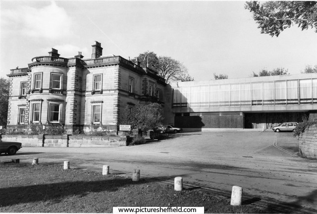
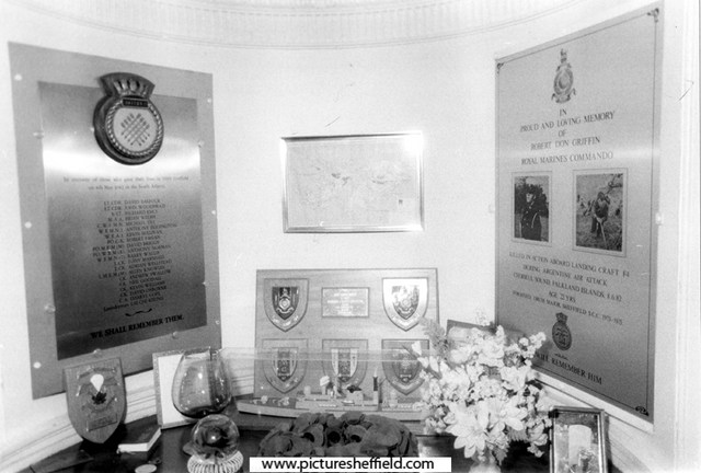
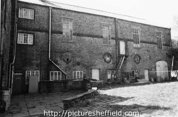
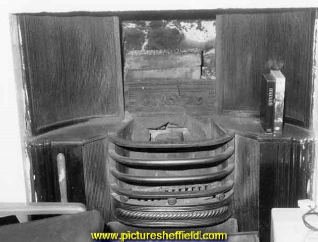
Loxley House, Ben Lane. Shirley Anne Gentle (nee Barber) outside Loxley House, Ben Lane 1999, which she attended 1940's early 50's as a child when it was Hillsborough High School. v04509 Loxley House 27th May 1952 https://www.picturesheffield.com/frontend.php?keywords=Ref_No_increment;EQUALS;s05771&pos=56&action=zoom&id=9182 Memorial to the men who died in the 1982 Falklands War, Loxley House. May 1997.s28449 Loxley House, whilst in use by the Sheffield Sea Cadets. May 1997 https://www.picturesheffield.com/frontend.php?keywords=Ref_No_increment;EQUALS;s37407&pos=31&action=zoom&id=73985 Front entrance to Loxley House, Ben Lane, Wadsley whilst in use by the Sheffield Sea Cadetss37435 Inside entrance to Loxley House, whilst in use use by the Sheffield Sea Cadets. May 1997s37408 Window at the top of the staircase, Loxley House. https://www.picturesheffield.com/frontend.php?keywords=Ref_No_increment;EQUALS;s37437&pos=39&action=zoom&id=74019 Fireplace in the upstairs office of Loxley House, May 1997s33572 Bar in Loxley House, whilst in use by the Sheffield Sea Cadets. May 1997. https://www.picturesheffield.com/frontend.php?keywords=Ref_No_increment;EQUALS;s37411&pos=35&action=zoom&id=73990 Rear of Loxley House, Ben Lane, Wadsley whilst in use by the Sheffield Sea Cadets. May 1997.s37412 Rear of Loxley House, May1997 https://www.picturesheffield.com/frontend.php?keywords=Ref_No_increment;EQUALS;s37434&pos=37&action=zoom&id=74014 Path from Ben Lane to Loxley House through grounds of Loxley House. March 1965. https://www.picturesheffield.com/frontend.php?keywords=Ref_No_increment;EQUALS;s32123&pos=49&action=zoom&id=35143


-
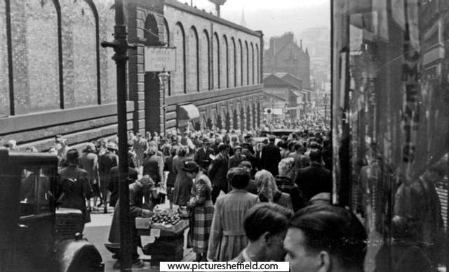
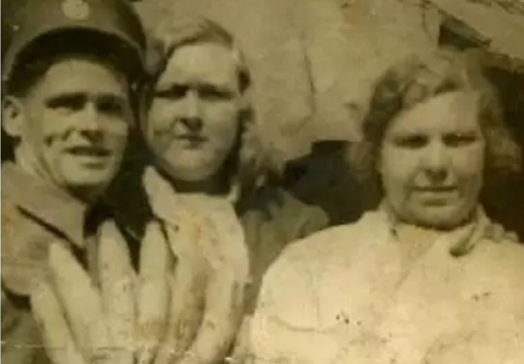
Does anyone remember the people in this photo? One is Big Ada from the old market on Dixon Lane Any memories of these people at all?
-
Plan showing West Hill, home of Fairbank. (left side of plan) Broomhall Street. The Burgesses land between West Street and the Moor (Blacklands, Lee Close), [1793], [1816] https://www.picturesheffield.com/frontend.php?keywords=Ref_No_increment;EQUALS;arc04065&pos=113&action=zoom&id=97106 On this have been plotted the streets laid out up to 1816, and measures of the coalpit added. The additions include Earl Fitzwilliam’s and the Duke of Norfolk’s allotments. Shows Glossop Road, West Street, Devonshire Street, West Hill, West Field Terrace, Division Street, Rockingham Street, Blackland Street, Button Lane on Little Sheffield Moor, Carver Street [and Fitzwilliam Street]. [Site of Devonshire Green]. Also James Bowden’s Land, J. T. Younge’s land, James Kirkby’s house, Upper, Middle and Lower Blacklands Close.
-
Plan of Whiteley Woods (Part 1) -section from Dead Lane to Forge Houses. 1897. https://www.picturesheffield.com/frontend.php?keywords=Ref_No_increment;EQUALS;y09356&pos=15&action=zoom&id=63677 Plan of Whiteley Woods (Part 2) -Whiteley Woods (Part 2) - section from Oakbrook Road to Dead Lane. 1897 https://www.picturesheffield.com/frontend.php?keywords=Ref_No_increment;EQUALS;y09358&pos=16&action=zoom&id=63679 Plan of estates at Rand Moor [Ranmoor] and Nether Green in the township of Upper Hallam the property of John Eyre. 1830. https://www.picturesheffield.com/frontend.php?keywords=Ref_No_increment;EQUALS;arc03994&pos=59&action=zoom&id=102815 1. Farm House with barns, stables, yards and gardens, 2 Small Croft, 3 Stackyard Field, 4 Upper Bank, 5 Broad Field, 6 Broad Field Bottom and Lower Bank, 7 Ibbotson Wood, 8 Four Days Work, 9 Broom Field, 10 part in the road, 11 Upper Lords Field, 13 Porter Wheel and ground open to it, 14 Woody Bank, 15 Dam, 16 Low Porter Field, 17 Middle Porter Field, 18 Middle Porter Field Bottom, 19 Near Porter Field Bottom, 20 Near Porter Field, 21 Rough Field and Fox Croft, 22 three dwelling houses with an outhouse yard and gardens, 23 garden, 24 farm house, yard, dwelling houses and garden, 25 House Field, 26 Woody Bank in [?House Field]. Names include Elizabeth Hawkesworth, John Beale, William Andrews, Susannah Ibbotson, George Stringer, Thomas Binney, Jos. Biggin, Hannah Elliott, George Parker, Edmund Wilson, Ebenezer Marsden, Geo. Worrall, William Fox, Mary Trippet, William Wilson. Shows Water Lane, Porter Bridge, road from Bents Green, Road from Whiteley Wood, Dam, Porter Wheel, Porter Brook, Ibbotsons Wheel, Ibbotson Wood, Spurgear Wheel Dam, Road to Lydgate, Road to Sheffield.
-
Hi does anyone have any information about a location known as Crooked Steps? It is shows as an ancestors address in the 1881 Census and listed as Harvest Lane. I've checked out Picture Sheffield but couldn't find any pics specifically listed as Crooked Steps. I know it was/is hilly around there so I'm guessing there literally were a set of crooked steps, it just seems odd to have as an address. Thanks in advance!
-
West Field House not identified on this Plan but comparing it to the previous map posted it's probably the grey shaded property next to West Field Terrace. Broomhall Street. The Burgesses land between West Street and the Moor (Blacklands, Lee Close), [1793], [1816] https://www.picturesheffield.com/frontend.php?keywords=Ref_No_increment;EQUALS;arc04065&pos=30&action=zoom&id=97106 On this have been plotted the streets laid out up to 1816, and measures of the coalpit added. The additions include Earl Fitzwilliam’s and the Duke of Norfolk’s allotments. Shows Glossop Road, West Street, Devonshire Street, West Hill, West Field Terrace, Division Street, Rockingham Street, Blackland Street, Button Lane on Little Sheffield Moor, Carver Street [and Fitzwilliam Street]. [Site of Devonshire Green]. Also James Bowden’s Land, J. T. Younge’s land, James Kirkby’s house, Upper, Middle and Lower Blacklands Close. Royal Hospital - Ground Plans showing how the site was developed. 1930. Plans of 1833 building (Westfield House), 1860, 1880, 1895, 1912 and 1927. https://www.picturesheffield.com/frontend.php?keywords=Ref_No_increment;EQUALS;h00010&pos=26&action=zoom&id=3905
-
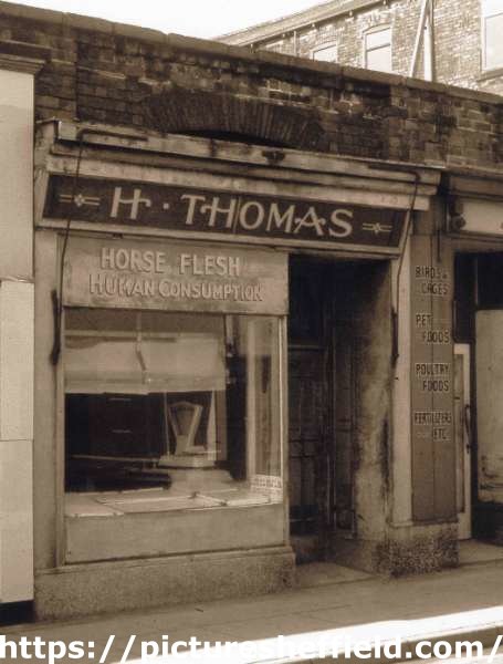
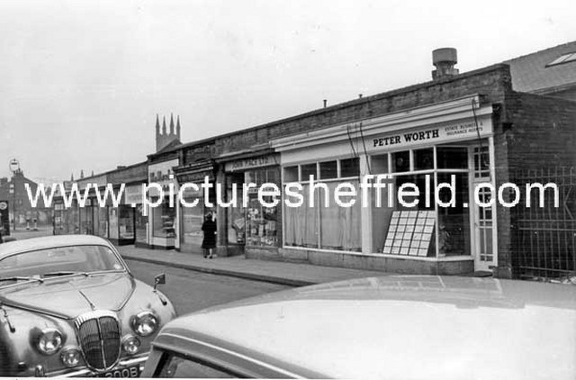
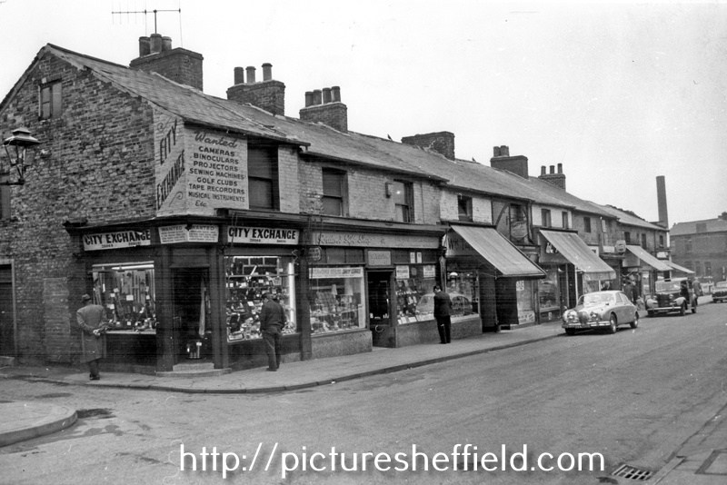
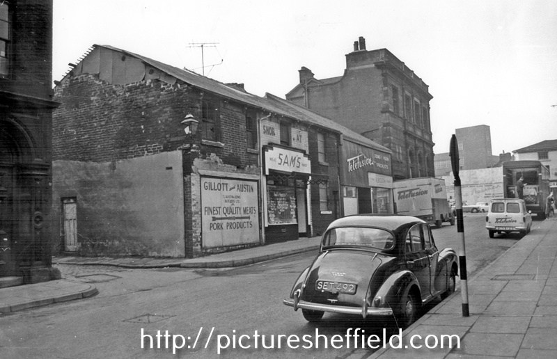
Not Part of the Shops built by Thomas Rowbotham. H. Thomas, horse flesh dealer, No. 28 Hereford Street. Sign reads: Horse Flesh Human Consumption. rb00024 Photographer: Ray Brightman, FRPS AFIAP DPAGB Hon PAGB. From The Ray Brightman exhibition collection. Hereford Street, premises include Peter Worth, Estate, and Insurance Agents, No 26, Jn. Mace Ltd., Pet Stores, No 28, H. Thomas, Horse Flesh Dealer, No 30, William Marsden and Son, Bakers. March 1965. s17124 Photographer: Estates Surveyors Department. Hereford Street at junction with South Lane, premises include No. 21 City Exchange, secondhand radio and television supplies, Nos. 23 - 25 Yospa Gordon, retail jeweller, No. 27 Wm. Talbot, Butcher. March 1965s17129 Photographer: Estates Surveyors. Hereford Street at Forge Lane junction, looking towards The Moor, No 14, Thos. J. Austin and Sons (Butchers) Ltd., No 10, Telefusion Ltd., Television Supplies. March 1965.s17122 Hereford Street after the demolition of Nos. 45 - 47 Bridge Inn, premises still remaining include No. 41 A.P. Smith and Bros. Ltd., butchers, No. 39 Fras. Turner, tobacconist, No. 35, Ernest Speechley, snack bar. July 1961.s17120 Photographer: J Lythgoe.
-

Birley Collieries Branch Line
RLongden replied to Paolo Coopio's topic in Sheffield Buses, Trams and Trains
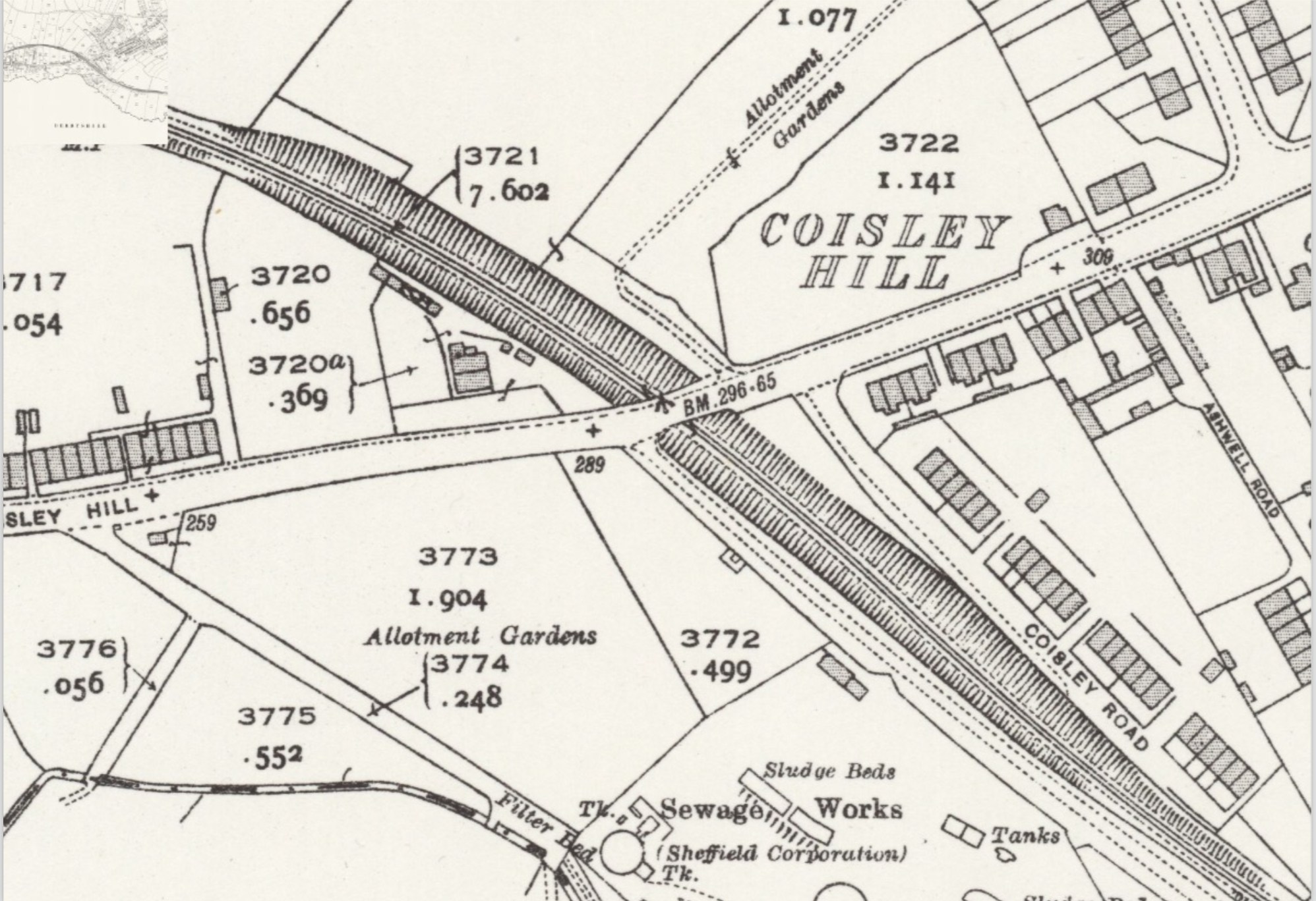
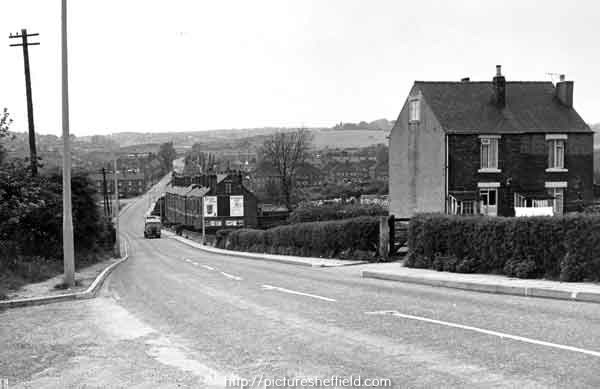
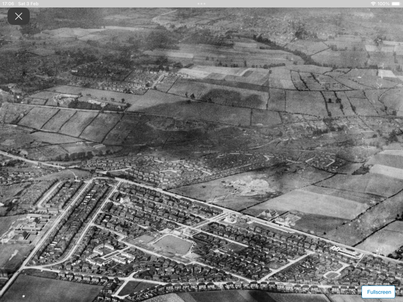
Yes you’re right, the line was in a cutting as it went under Coisley Hill, as you can see from the map detail https://maps.nls.uk/view/125651476 Also, you can see in the image, the photographer must have been stood on the pavement on the bridge, with Stone Lane to their left and the two cottages on the right… the rail line is just out of shot on the right. https://www.picturesheffield.com/frontend.php?keywords=Ref_No_increment;EQUALS;s43471&pos=11&action=zoom&id=85665 An aerial view from 1939, taken over Frecheville, looking over towards Stradbrooke Road, you can see Birley West Colliery in the junction of Linley Lane and Normanton Hill. The rail line passes under Normanton Hill, curves right in an arc, through the fields and it disappears off the right edge of the page, before it crosses Coisley Hill. https://www.britainfromabove.org.uk/en/image/EPW062831 Amazing really that roads and houses have encroached on the area, yet the route it still visible today 😁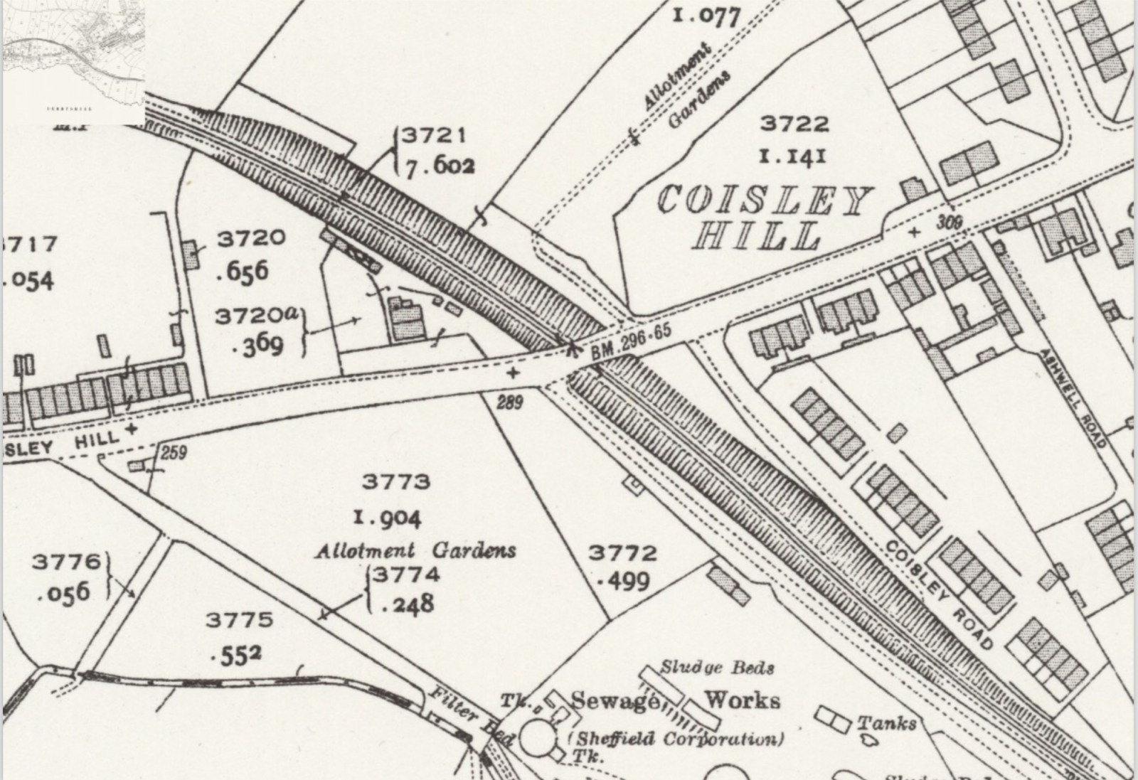
-
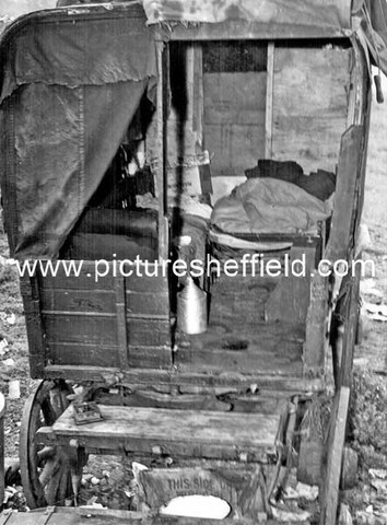
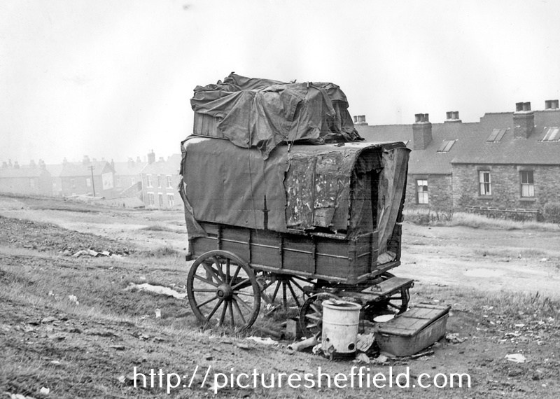
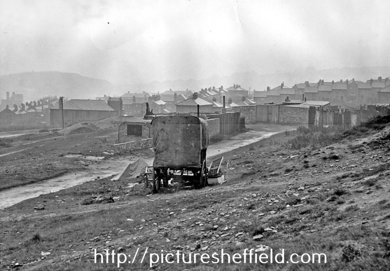
Ex-Railway type van in a deplorable condition, placed on waste land and housing a man and wife and their child aged 1 year and 9 months, and another adult female, both females were pregnant. 31st August 1950. u01685 Photograph shows an ex-railway type van placed on waste land in June 1950. The van measured 8' 9 long, 5' 0 wide and was 5'7 high. The van was in a poor condition and there was no sanitary accommodation or water supply, lighting was by candles and there was a coal fired, metal stove inside the van. The van was generally in a deplorable condition, and the site around was littered with refuse. The occupants were a man and wife and their child aged 1 year and 9 months, and another adult female. Both adult females were expectant and both had other children, either with foster parents or in childrens homes. The occupants were eventually found accommodation by the Social Care Department. u01684 u01686