Search the Community
Showing results for 'coal pit lane'.
-
A map of Cinderhill Wheel Old Dam and the additions intended to be made to it. 1752. https://www.picturesheffield.com/frontend.php?keywords=Ref_No_increment;EQUALS;arc03406&pos=91&action=zoom&id=98649 The old and new dams clearly shown, with a perspective drawing of the mill house. Measurements given on the map and there is an explanation of additions with acreages. Content of the new dam also given; house and border coloured. Pond Corn Mill (on the Porter) and some of the Stand Ley Closes (also known as the Cinder Hill Wheel, this Mill was west of modern Leadmill Road near Shoreham Street; the Stand Ley Closes lay to the south and west of the mill and dam). Brittain Street, St Mary's Road, Shoreham Street, Pond Corn Mill, Mary Street, Pond Street (south end). A map of the Stand Leys and some other contiguous Lands with the Dam and Mill (formerly called Cinder Hill Wheel) 1764. https://www.picturesheffield.com/frontend.php?keywords=Ref_No_increment;EQUALS;arc03415&pos=93&action=zoom&id=98651 arc03415 The Wheel and Dam clearly shown; shuttle marked; colours distinguish tenancies; numerical list with tenants, field names and descriptions and acreages; on parchment. Pond Corn Mill (on the Porter) and some of the Stand Ley Closes (also known as the Cinder Hill Wheel, this Mill was west of modern Leadmill Road near Shoreham Street; the Stand Ley Closes lay to the south and west of the mill and dam). Clough House Lane, with the site of Clough House shown. Lenton Street, Duchess Road, Pond Corn Mill, Mary Street, Margaret Street, Matilda Street, Pond Street (south end), St. Mary's Road.
-
A plan of two Closes held under the Duke of Norfolk by Benjamin Roebuck, with Silvester Wheel [Sylvester Wheel] and the adjoining Damms (sic) and Gardens in John Wilson's possession, [c. 1760-1770] https://www.picturesheffield.com/frontend.php?keywords=Ref_No_increment;EQUALS;arc03285&pos=87&action=zoom&id=98446 Upper and Lower Dams, Wheel and Weirs clearly shown; includes two closes to the north of the dams; numerical list with tenants, descriptions and acreages; coloured, on parchment. Sylvester Wheel and the closes to the south (these closes adjoin those in the section above; the wheel was on the Porter Brook near modern Sylvester Street). (Alsop Lane, Earl Lane, Earl Street, Eyre Street, Jessop Lane, Jessop Street, Sylvester Street) Silvester Wheel with the Dams and Appurtenances held of the Earl of Surrey by John Wilson. 1784. https://www.picturesheffield.com/frontend.php?keywords=Ref_No_increment;EQUALS;arc03286&pos=88&action=zoom&id=98447 Wheel, Dams and Gardens clearly shown; measurements of gardens Sylvester Wheel and the closes to the south (these closes adjoin those in the section above; the wheel was on the Porter Brook near modern Sylvester Street). A plan of the Stand Ley Closes, etc. 1790. https://www.picturesheffield.com/frontend.php?keywords=Ref_No_increment;EQUALS;arc03414&pos=92&action=zoom&id=98650 The closes adjoining those shown in arc03415 with an outline of the Sylvester Wheel and Dams; Tenants and acreages given. (St. Mary's Road, Charlotte Road, Clough Road, Clough House Lane, Hereford Street, Sylvester Street, Mary Street, Midland Lane, Margaret Street, Shoreham Street) [Sylvester Wheel and the closes to the south (these closes adjoin those in the section above; the wheel was on the Porter Brook near modern Sylvester Street] Plan of the Duke of Norfolk's land in Alsop Fields and at Sylvester Wheel divided into lots for sale. 1804. https://www.picturesheffield.com/frontend.php?keywords=Ref_No_increment;EQUALS;arc04029&pos=64&action=zoom&id=103259 The plan shows the plots bought and the later building schemes. Shows Hereford Street, Cumberland Street, Jessop Street, Silvester Street [Sylvester Street], Arundel Street, Furnival Street, Porter Lane, Eyre Street, Duke Street, [Porter Brook], new cut, lsquo;old course of the river rsquo;, bridge, wear [weir]. Refers to Thomas Holy, George Rhodes, Joshua Holdsworth, John Watson, James Bean, Isaac Smith, Robert Mills, William Tyson, Ann Fox, Joseph Waterhouse, Michael Riley, Sarah [Broomhouse?], Edward Maden / Madin, Samuel Kirkby, John Gillott, Malin Gillot, William Howson, Dr. Firth, [?R. Cindell], E. W. Drury, John Hornden, M.D., Thomas Warburton, Joseph Herrings, George Prior, William Littlewood, Joseph Smith. Plan of certain freehold land near Sylvester Wheel, the property of Thomas Holy. 1831. https://www.picturesheffield.com/frontend.php?keywords=Ref_No_increment;EQUALS;arc04273&pos=75&action=zoom&id=105747 Marked: Sylvester Street, Sylvester Wheel, River Porter, upper dam, lower dam, land sold to Earl Fitzwilliam, Ellin Lane, tail goight, Arundel Street, Arundel Lane, Jessop Street, Eyre Lane, and Earl Street.
-
Bennett Wheel. A plan of the Cutler's Wheel House on Little Sheffield Moor held of the Earl of Surrey by James Bennett. 1784. https://www.picturesheffield.com/frontend.php?keywords=Ref_No_increment;EQUALS;arc03503&pos=82&action=zoom&id=91098 Bennett's Wheel and Dam, the watering place and all the courses of the River Porter shown; some measurements. Watering Place. (Ellin Street, St Mary's Road). Weighing machine house and some ground adjoining Bennet’s Dam belonging to George Bennet, [1807] https://www.picturesheffield.com/frontend.php?keywords=Ref_No_increment;EQUALS;arc03640&pos=33&action=zoom&id=99191 Bennett's Wheel and the land adjoining as divided into lots for sale, The Moor, [1819] https://www.picturesheffield.com/frontend.php?keywords=Ref_No_increment;EQUALS;arc04155&pos=70&action=zoom&id=104118 The plan includes a building scheme over the part of the dam adjoining South Street, but it was not proceeded with. Shows South Street, Hereford Street and Porter Lane. Also, [River Porter] and Bennett's Wheel. Bennett's Wheel and premises adjoining agreed to be sold to Thomas Ellin. 1831. https://www.picturesheffield.com/frontend.php?keywords=Ref_No_increment;EQUALS;arc04156&pos=71&action=zoom&id=104119 Marked: South Street, Hereford Street, Porter Street, Sylvester Street, bridge, River porter, wear [weir], goight, tail goight, Bennets [Bennett's ] Wheel, dam, Back Lane, bye wash, and garden. Tenants / owners: Samuel Newbould, John Watsen [Watson], Peter Jerrison, and late George Hodgson. Note: the Field Book has Sylvester Wheel, but this is palpably an error.
-
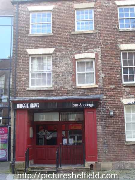
Maggie May's, bar and restaurant, Trippet Lane. 2017. a03748 Photographer: Andrew Milroy Formerly No. 27, Brown Cow? Maggie May's, 23-27, Trippet Lane. https://publocation.uk/pubs/south-yorkshire/sheffield/maggie-mays It would be good to know what was on the sign at No. 27 (right) Is it Brown Cow? West Bank Lane from Trippet Lane, No. 23 Walter Trickett and Co Ltd., spoon and fork makers, Anglo Works, left. July 1969. s20375
-
A plan of several proposed building lots [tenements between Holly Street and Holly Lane, including property on West Street] 1790. Property on the west side of Holly Street [Blind Lane]. Some yardage given. Includes reference to Red Croft. https://www.picturesheffield.com/frontend.php?keywords=Ref_No_increment;EQUALS;arc03200&pos=48&action=zoom&id=98268 Property in Red Croft which became known as the Brown Cow is shown as owned by Geo. King.
-
No. 27 Trippet Lane and the junction of West Bank Lane. https://www.picturesheffield.com/frontend.php?keywords=Ref_No_increment;EQUALS;v02668&pos=19&action=zoom&id=44370 Former premises of Walter Trickett and Co Ltd., Anglo Works (extreme left) and No. 27 Trippet Lane with West Bank Lane between. 2001. https://www.picturesheffield.com/frontend.php?keywords=Ref_No_increment;EQUALS;v03115&pos=2&action=zoom&id=44812 Former premises of the (Old) Brown Cow?
-
After my initial post found this Link to: A Very Difficult Question. https://www.sheffieldhistory.co.uk/forums/topic/7409-a-very-difficult-question/ Found these posts intriguing thanks Stuart0742 & RichardB. I'm so glad I found the plan of Brown Cow, Red Croft. Next step needed: detailed maps of Red Croft/Trippet Lane from 1840`s upwards and any information from newspapers regarding the road improvements on Trippet Lane.
-
The Brown Cow Public House in Red Croft, measured for Rawson and Co. 1815. https://www.picturesheffield.com/frontend.php?keywords=Ref_No_increment;EQUALS;arc03718&pos=1&action=zoom&id=99298 The Brown Cow measured for T Rawson and Co., [1832] https://www.picturesheffield.com/frontend.php?keywords=Ref_No_increment;EQUALS;arc03719&pos=2&action=zoom&id=99299 Sheffield History A-Z Public Houses Brown Cow, Red Croft, Open 1774. 1774 John Sheppard [ razor maker ] 1825 - 1834 Jonathan Gould 1837 Richard Waistnege 1839 Richard Waistnege 1841 William Harrison Plan for the improvement of Trippet Lane and Pinfold Lane. 1836. Shows junction of Portobello Street, Bailey Lane and Trippet Lane, Bailey Street, Holly Street, and the junction of Pinfold Lane with Bow Street and Church Street. Also shown is Red Croft. https://www.picturesheffield.com/frontend.php?keywords=Ref_No_increment;EQUALS;arc04275&pos=13&action=zoom&id=105917 Marked are premises purchased by the Town Trustees of Richard Cardwell, Mrs Bennett, William Blackford and Edward Webster; as well as properties of Skelton, Edward Webster, George Bennett, George Ellis, and Rawson and Co. Plan for the improvement of Trippet Lane and Pinfold Lane, [1844] With a memorandum of lands purchased by the Town Trustees up to the end of 1843. Shows junction of Portobello Street, Bailey Lane and Trippet Lane, Bailey Street, Holly Street, and the junction of Pinfold Lane with Bow Street and Church Street. Also shown is Red Croft. Marked are premises purchased by the Town Trustees of Richard Cardwell, Mrs Bennett, William Blackford and Edward Webster. https://www.picturesheffield.com/frontend.php?keywords=Ref_No_increment;EQUALS;arc04276&pos=14&action=zoom&id=105918 Properties on Trippet Lane (in front of Red Croft) were demolished for road improvements. It is possible the (Old) Brown Cow became 27 Trippet Lane from this time. Unless of course it was rebuilt. Sheffield History A-Z Public Houses. Brown Cow/Old Brown Cow/Trippet Lane Arms, 27 Trippet Lane. 1845 John Andrews 1846 John Andrews 1849 L Fearnley 1852 I Fearnley 1856 Alfred Capper/ George Gregory 1859 William Bradley 1862 Joseph Knight 1863 Joseph Knight 1864 Joseph Wright 1865 Joseph Wright 1868 Sarah Wild 1871 Mrs Sarah Wild (Widow) 1876 Sarah Wild 1879 William Ball [ Old Brown Cow ] 1881 William Ball (Trippet Lane Arms) 1883 William Ball 1887 to 1890 William Ball 1893 Mrs Ann Ball 1895/6 Mrs Ann Ball 1898 Charles A Ball [ Old Brown Cow ] 1900 Charles A Ball 1901 William Pickard 1902 William Pickard 1903 William Pickard 1905 William Pickard 1907 Charles Oliver [ 27 Trippet Lane ] West Bank Lane at rear of Old Brown Cow P. H., looking towards entrance off Trippet Lane. July 1969. s20374

-

John M Stanley, Ironfounders & Manufacturer of Stovegrates etc., Midland Works, Savile Street East
Edmund replied to Ponytail's topic in Made In Sheffield
As the man says, beware of namesakes. The Whites Directory for 1862 includes another Stanley Brothers, merchants and steel and file manufacturers, Harmer Lane, probably James and Thomas Stanley. John Stanley retired to Rhyl after his bankruptcy in 1866, though he was still writing and inventing. In 1880 he (unsuccessfully) took the proprietors of the Rhyl Advertiser to court for libel regarding his book "The Missing Link" (re Darwin). They moved to Camberwell, London where his wife Sarah Ann died in May 1887 and John died (at Guy's Hospital) on 18th November 1892.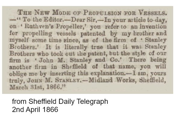
-

The Estate of Joseph & William Wilson (Snuff Mills, Sharrow & Ecclesall etc.)
Ponytail replied to Ponytail's topic in Sheffield History Chat
A plan of several footways near Sharrow Mills proposed to be discontinued or changed, measured for Joseph Wilson. 1820. https://www.picturesheffield.com/frontend.php?keywords=Ref_No_increment;EQUALS;arc04012&pos=146&action=zoom&id=103148 "The Roads proposed to be discontinued coloured red, those proposed to be substituted for them are coloured yellow" Shows Hunters Bar, Sharrow Moor Bottom, [Sharrow Vale Road, Ecclesall Road, Psalter Lane, River Porter, Cemetery Road], Broomhall Mill, Sharrow Mills, Sharrow Head, Porter Brook, Chesterfield Roads, Little Sheffield, water place [where Ecclesall Road met Chesterfield [London] Road], Stalker Wheel, Brocco Bank Wood, Clarkehosues, [Brocco Bank], Endcliffe Wood. -
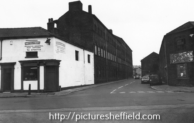
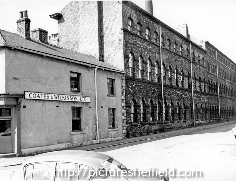
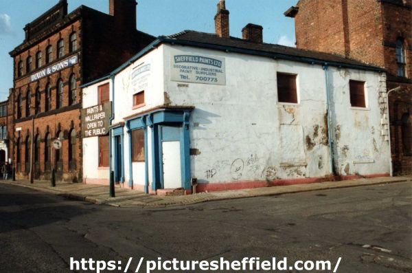
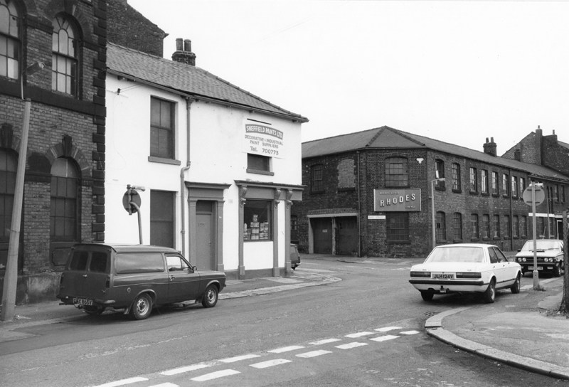
Plan of The Ball, Green Lane at the junction with Ball Street, measured for T. Rawson and Co. 1815. https://www.picturesheffield.com/frontend.php?keywords=Ref_No_increment;EQUALS;arc03597&pos=149&action=zoom&id=99086 Sheffield Flood Claim 1864: John Stringer, Inn keeper, Ball Inn, 84 Green Lane. Claimed for loss of business (34 weeks) as the Ball Street Bridge was washed away. https://sheffieldfloodclaimsarchive.shu.ac.uk/claimSummary.cfm?claim=4-3966 Also, John Stringer, publican of Green Lane made a personal claim (later withdrawn) listing items. https://sheffieldfloodclaimsarchive.shu.ac.uk/claimSummary.cfm?claim=7-5956 The claim was probably withdrawn as the Brewery of Thomas Rawson & Company made a Claim for several of their premises, including "Ball Inn Public House, Cottage and Premises" https://sheffieldfloodclaimsarchive.shu.ac.uk/claimSummary.cfm?claim=6-5445 Also, Samuel Bennett a private watchman who resided in the "Ball Yard" claimed for personal injury, "cold" which prevented him from working for 4 weeks. https://sheffieldfloodclaimsarchive.shu.ac.uk/claimSummary.cfm?claim=9b-58 Ball Street (junction of Green Lane), Neepsend, Coates and Wilkinson Ltd., printers, Hylton Works former Ball Inn, No. 84 Green Lane and James Dixon and Son, Cornish Place Works, electro-plate and silver manufacturers. 28th June 1965. s13217 Sheffield Paints Ltd., (formerly Ball Inn) No. 84, Green Lane at the junction with Ball Street showing (left) James Dixon and Sons, Cornish Place Works, Cornish Street. u11701 Sheffield Paints Ltd., (formerly Ball Inn) No. 84, Green Lane looking towards the junction with Ball Street and Rhodes, machine knives and springs, Brooklyn Works (former premises of Alfred Beckett and Sons Ltd., (right) 1st August 1985. s25572 Sheffield Paints Ltd. (formerly Ball Inn), No. 84 Green Lane looking towards Ball Street, with Alfred Beckett and Sons Ltd., Brooklyn Works, steel, saw and file works (right) and former James Dixon and Sons, Cornish Place Works (left). October 1997. s25219 Renamed and opened as the Millstone, Bar and Restaurant. https://pubshistory.com/Yorkshire/SheffieldB/BallGreen.shtml
-

The Estate of Joseph & William Wilson (Snuff Mills, Sharrow & Ecclesall etc.)
southside replied to Ponytail's topic in Sheffield History Chat
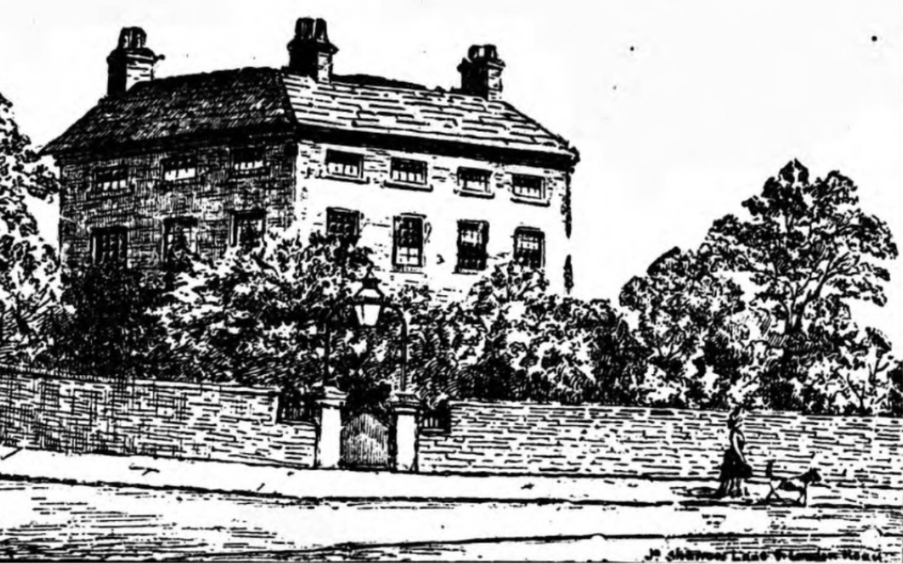
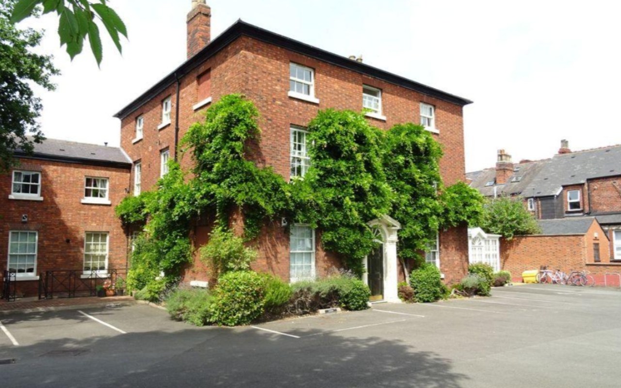
The History of Wilson's & Co: website link https://sharrowmills.com/pages/our-history Joseph Wilson lived at Highfield/Brightfield House on Sharrow Lane in the 1760s. This became the Charnwood Hotel in the 1980s, now turned into a block of apartments (Wisteria Court)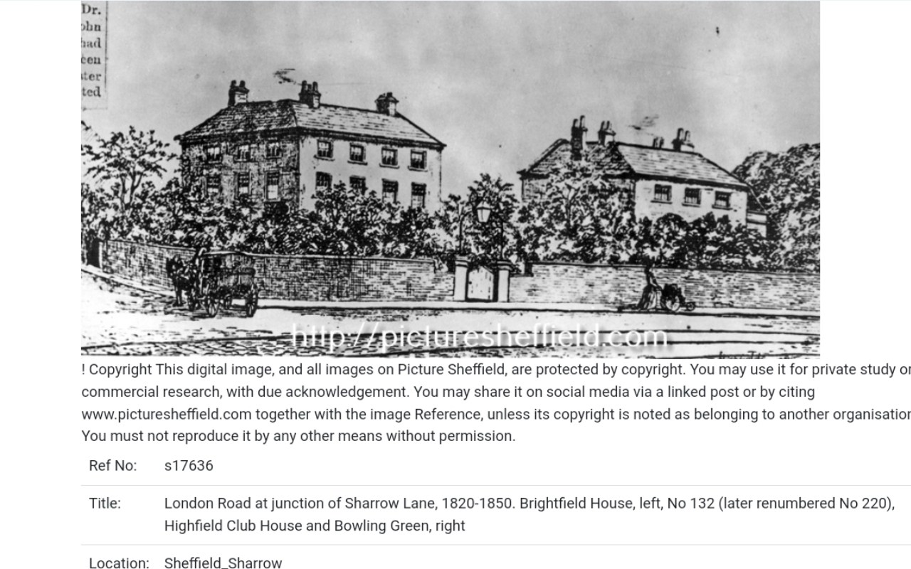
-
The Estate of Joseph & William Wilson (Snuff Mills, Sharrow & Ecclesall etc.)
Ponytail posted a topic in Sheffield History Chat
Plan of the Snuff Mill, Cutler's Wheel, adjoining the Dam etc at Sharrow Moor, occupied by Joseph Wilson and Edwd. Anderton. 1764. https://www.picturesheffield.com/frontend.php?keywords=Ref_No_increment;EQUALS;arc02724&pos=63&action=zoom&id=92116 Map of the Estate of Joseph and William Wilson, Ecclesall Road, 1820. The watermark is 1819: Ecclesall Road (finished 1817) has been made; and J Wilson and Co. had nearly all their lands surveyed in 1820. Also shows Hunter House and Hunters Bar. https://www.picturesheffield.com/frontend.php?keywords=Ref_No_increment;EQUALS;arc03950&pos=39&action=zoom&id=102036 The estate of Joseph and William Wilson. Plan of Clifford, Psalter Lane, and Sharrow Mills, [c. 1820] Shows Clifford (with pleasure ground and gardens), workhouse [on Psalter Lane], West Brook, River Porter, weir, Sharrow Mills (with dam and banks and stack yard), lodge, school, [Ecclesall Road], [Sharrow Vale Road]. https://www.picturesheffield.com/frontend.php?keywords=Ref_No_increment;EQUALS;arc06147&pos=46&action=zoom&id=101163 Plan of several estates in the townships of Ecclesall Bierlow and Nether Hallam, the property of Joseph and William Wilson [c. 1825-1830] The watermark is 1825. https://www.picturesheffield.com/frontend.php?keywords=Ref_No_increment;EQUALS;arc03951&pos=40&action=zoom&id=102040 Map of the Estate belonging to the late William Wilson lying between Sharrow Mills and Endcliff Woods made to shew to whom each part now belongs, [watermarked 1838] https://www.picturesheffield.com/frontend.php?keywords=Ref_No_increment;EQUALS;arc03955&pos=44&action=zoom&id=102361 Field names, etc. not marked. Based on arc03953 and arc03954 they are: Wood Field, Long Field, Spring Field, Square Field, Upper Delf Field, Endcliffe Wood, Endcliffe Vale Road, Clarke House Road (sic) later Brocco Bank, Turnpike Road [Ecclesall Road], Occupation Road, Brocco Bank Allotment, Botanic Garden, Nether field, Great Tom Field, Wadbro rsquo; Close, quarry, Little Tom Field, Brocco Bank Close, River Porter, Lower Delf Field, [Hunters Bar] Toll Bar, Hunter House, Lescar Wheel, Lescar Wheel Road [later Sharrow Vale Road, homestead, [Sharrow Snuff Mills], Walsh Stubbings, The Meadow, Meadow of Walsh Stubbings, Holme Meadow. [Snuff Mill Lane, Stalker Lees Road, General Cemetery, Rosedale Road, Cemetery Avenue, Harefield Road, Denham Road, Harland Road, Neill Road, Eastwood Road. Meadow Terrace, Clarkehouse Road, Botanical Gardens, Endcliffe Vale Road, Botanical Road, Rossington Road, Wiseton Road, Newington Road, Endliffe Terrace Road, Endcliffe Rise Road, Wilson Road, Dover Road, Wadbrough Road, Southgrove Road, Broomgrove Road, Collegiate Crescent, Thompson Road, Khartoum Road, Walton Road, Bristol Road, Bagshot Street, Bruce Road, Westbrook Bank, Stewart Road, Ratcliffe Road, Jarrow Road, Gordon Road, Lynton Road, Wayland Road, Bowood Road]. Map of the Estate belonging to the late William Wilson lying between Sharrow Mills and Endcliffe Wood, made to shew each parcel of land described in the purchase deeds, [Watermarked 1844] Shows Toll Bar and position of Gates. https://www.picturesheffield.com/frontend.php?keywords=Ref_No_increment;EQUALS;arc03954&pos=43&action=zoom&id=102360 Map of the Estate belonging to the late William Wilson lying between Sharrow Mills and Endcliffe Wood made to shew to whom each part now belongs, c. 1850. https://www.picturesheffield.com/frontend.php?keywords=Ref_No_increment;EQUALS;arc03953&pos=42&action=zoom&id=102052 -
William Hibbert (senior) was born in Hartington, Derbyshire in 1806. He was a carver and gilder in Baslow and married Matilda Marples (dressmaker) on 23rd April 1832 at Baslow. He had probably already done a lot of business carving and gilding at Chatsworth House, as shortly after they moved to Sheffield, an advertisement referred to examples of William's workmanship. In 1841 the shop was at 78 Fargate (the 1850 Whites Directory shows Fargate and Barkers Pool as being the same road, with consecutive numbering). The shop was just below Pool Place, opposite the Scarbrough Arms. At this point the family were living in Broomspring Lane. By 1843 Hibbert was in partnership with brother in law George Marples, with shops at both 78 Fargate/Barkers Pool and 31 Church Lane. In March 1845 the partnership was dissolved and William Hibbert took the Fargate shop, George Marples had the Church Lane shop. William senior died aged 62 on 16th March 1868 at his residence in Parkers Road, Broomhill. William (junior) was born on 3rd September 1835, and married Julia Stocks on 23rd September 1856. They had surviving children - a son and four daughters - Thomas George, Julia, Annie, Florence and Matilda. In October 1881 Hibbert Brothers, late of 86 Fargate, established 1834, removed to the Norfolk Art Galleries, Norfolk Street and Surrey Street. WIlliam Hibbert (junior) died aged 77 at 96 Broomspring Lane on Saturday 24th February 1912. He had retired about 8 years previously, the business being continued by his son Thomas George. William was buried at Ecclesall on 28th February. A week later on 5th March 1912 at Ecclesall, his brother Samuel George Hibbert, aged 73, also of 96 Broomspring Lane, and a retired carver-gilder, was buried. Thomas George Hibbert died aged 68, residence "Goathland", Bushey Wood Road,Totley Rise and Norfolk street. He died on 18th December 1928. He had been a well known amateur photographer from 1880 up until the first war. An 1890 photo taken by Thomas G Hibbert from outside the new premises was discussed in detail on this forum: The next incumbents of the shop was Thomas G's son Arnold Edgar (born 31st August 1879 and died in 1950) His children, who also came into the business were Frank Arnold (born 8th December 1906), Mary (born 1910, married Albert Lidgard), Freda (born 23rd June 1914). Frank died on 26th January 1945, before his father, who was an executor of his will. Mary and Freda were involved in the running of the business into the 1980's.
-
A map of the land taken for the use of the White-lead Work, with the Buildings etc. 1759. White Lead Works and the fields between the Porter and the Sheaf, on either side of (Leadmill Road). Boatman's Bridge. Pond Street (south end). Surveyor: William Fairbank I. https://www.picturesheffield.com/frontend.php?keywords=Ref_No_increment;EQUALS;arc03403&pos=1&action=zoom&id=98646 A plan of several gardens in Pond Lane held by sundry persons of the Duke of Norfolk, and a plan of the course of the pipe conveying water from the Bath through them to the White Lead Works, [1777] Reference: [?leased] by the Whitelead Company of the Earl of Surrey. The White Lead Mill, cutlers wheel, dwelling houses, stackhouses and all the other buildings; Alegar yard, middle yard, litter yard, yard betwixt the damm and the mill, court by the mill. Also marked tilt damm, goight, River Porter, Boardman's Bridge, Pond Lane, John Waterhouse's tenement, William Nicholson, Thomas Needham, Robert Burnand, William Woolhouse, Widow Beard, Lydia Marriott, Nathaniel Cosins, John Burkett, Peter Spencer, John Wigfall, William Ruddinforth, and James Hattersley's land. https://www.picturesheffield.com/frontend.php?keywords=Ref_No_increment;EQUALS;arc04203&pos=11&action=zoom&id=105138 A plan of the Farm lately held of the Duke of Norfolk by Geo. Calton, with the Whitelead Works, etc. erected thereon. Surveyor: [William Fairbank II]. Fields between the Porter and the Coach-and-Six Farm and between the White Lead Works and the Corn Mill dam; Lead works and Cutler's Wheel clearly marked; numerical list with field names and descriptions and acreages; Proposed new course of the River Porter added, with new acreages listed. (Shoreham Street, Arundel Street, Brown Street, Furnival Street, White Lead Works, Leadmill Road, Leadmill Street, Matilda Lane, Matilda Street, Pond Street (south end), St Mary's Road) White Lead Works and the fields between the Porter and the Sheaf, on either side of (modern Leadmill Road) https://www.picturesheffield.com/frontend.php?keywords=Ref_No_increment;EQUALS;arc03404&pos=2&action=zoom&id=98647
-
Plan showing location of New Market Hotel, proposed to be purchased and also leasehold premises to be surrendered. Shows Sheaf Lane, Sheaf Street, Sheaf Market, Broad Street, Pheasant Inn, Horse and Jockey and Queen's Head. https://www.picturesheffield.com/frontend.php?keywords=Ref_No_increment;EQUALS;arc03510&pos=5&action=zoom&id=98730 OS Map surveyed 1889. 294.08.17 https://maps.nls.uk/view/231282561#zoom=4&lat=10269&lon=11559&layers=BT
-
Sheffield Boys Working Home for Destitute Boys, 82 Broomspring Lane
Ponytail replied to Ponytail's topic in Sheffield History Chat
Sheffield Boys Working Home for Destitute Boys, Broomspring Lane. " We help those who try and help themselves." https://www.ebay.co.uk/itm/295480990436.webp.9617d388a5c94e77c48dddf86c8b70f3.webp)
-
Sheffield Boys Working Home for Destitute Boys, 82 Broomspring Lane
Ponytail replied to Ponytail's topic in Sheffield History Chat
Link to: https://www.sheffieldhistory.co.uk/forums/topic/9524-sheffield-boys-working-home-broomspring-lane/ -
Sheffield Boys Working Home for Destitute Boys, 82 Broomspring Lane
Ponytail replied to Ponytail's topic in Sheffield History Chat
Boys Working Home at 82 Broomspring Lane, 1901 Census. Run by Alfred Stubbing and his wife Sarah. https://www.ourbroomhall.org.uk/content/explore/places/hospitals-and-homes/boys-working-home-82-broomspring-lane-1901-census See also the Comments below the article. "If you Check out the Sheffield Daily Telegraph 7/12/1918 there is an article about some of the former boys that served in WW1 By Nick Beeley (31/10/2017)" " My wife’s grandparents (Windle) also ran this home in the early 1900’s. She has a write up about it and photos of the boys during this period. Copies available to anyone interested. By Tony Biles (09/10/2015)" -
Sheffield Boys Working Home for Destitute Boys, 82 Broomspring Lane
Ponytail posted a topic in Sheffield History Chat
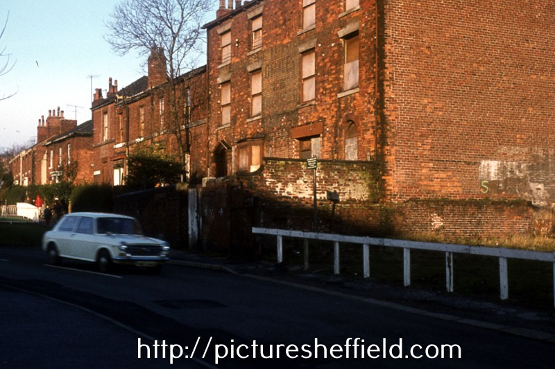
Sheffield Boys Working Home for Destitute Boys, 82 Broomspring Lane. 1889. https://www.picturesheffield.com/frontend.php?keywords=Ref_No_increment;EQUALS;q00003&pos=110&action=zoom&id=26303 Detail from Ordnance Survey Map, sheet no. Yorkshire 294-7-24. Sheffield Red Book, 1912 (page 207): The Sheffield Boy's Working Home was founded in 1881 to provide a home for boys in a state of physical or moral destitution, the relief of mothers of fatherless children; and to afford a measure of education and give the boys an opportunity of earning an honest livelihood; there is accommodation in the home for 40 boys; there is no workhouse atmosphere about the place, and boys are allowed to visit their friends on Sundays .. the home is supported by subscriptions, and by the earnings of the boys. No. 105, Upper Hanover Street (left) and Nos. 86-82, Broomspring Lane with Springfield School in the background. February 1974 82 Broomspring Lane was formerly the Sheffield Boys' Working Home. w01745 Nos. 82-88, Broomspring Lane, February 1974. w01743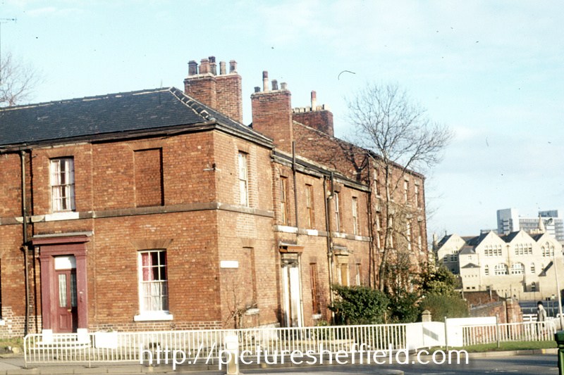
-
Norfolk Street & Beyond Before we escape back to 19th century Sheffield, I must thank Jane Salt the Stars Archivist for helping with my research, back to when thing seemed more refined. The clue picture on page two shows decorative carvings on what is now the Wicker Herbalist Stores, formerly Hibbert`s Art shop on Norfolk Street. Hibbert Brothers vacated the shop in 1998, the Star covered this event with a brief history of William and James Hibbert, it was claimed, quite wrongly, that the shop had opened in Norfolk Street in 1833, in that year Henry Thomas, a Doctor/ Surgeon, was living and practising from his house at 79 Norfolk street, which wasn’t the original postal number of Hibbert's shop, it was originally 38, it is a fact that William Hibbert was conducting his business at 78 Fargate (now Exchange Gateway) as a carver and gilder and its listed as an artists repository, William lived on the premises, his brother in law George Marples had the same occupation and was going about his business at 31 Church Street and he lived at 59 Bernard Street with his family. John Hibbert, Williams brother was also a carver and gilder plus a picture frame maker, map stretcher and varnisher, John was based on Chester Street, this street has been lost completely, thank you Sheffield council. By 1849 Henry Thomas the Surgeon took on a partner for his practice because of his growing practice, John Taylor Porter changed the practice name to Thomas & Porter, John Porter had been living at 27 Norfolk Street, so it was just a short walk to the practice, I could only speculate on what happened to these two doctors but I suspect they two partners decided to retire, Henry Thomas died in 1882, while his partner John Porter had died just eight years before him, so they must have sold the practice prior to 1852 as by that year Doctor / Surgeon Thomas Chesman who was the senior surgeon at the Public Hospital, Later the Royal Hospital, was holding his surgeries from the practice, sadly Thomas Chesman left this life on the 9th of November 1874, as the years passed the property, had had its postal number changed twice from 115 to what it is today 117, in 1893 William Murfin the London & North Western Railway Co goods manager was living at the property which is now Mammas & Leonie’s Pizza Parlour. So it looks as though Hibbert Brothers moved into the premises round about the late 1890s are now supplying the needs of both professional and amateur artists in the town, so they had only been selling their wares from Norfolk Street for just over a hundred years not 164 as claimed but that’s irrelevant as its still an important part of Sheffield’s history. By 1905 William Hibbert was living at 96 Broomspring Lane and John lived at 9 Westbourne Road the other brother Samuel George was residing at 42 Brocco Bank. This area of the town was always busy especially when the Surrey Street Music Hall was open, this grand theatre was built in 1823, it was more than just a Music Hall as its largest room accommodated 1,000 people quite easily, this theatre was just one of many in the town, the Gaiety, the Britannia, the Grand, the Phoenix, the Theatre Royal and of course Tommy Youdan’s which was the Alexandre Theatre on Blonk Street, I cant name them all but it was a cut throat business and nobody made a fortune out of them, if one owner or manager was breaking the rules, a rival sent in a spy to report back which in turn an official complaint was made against them via the watch committee. The Surrey was regarded as one of the best, if not the best, the world famous violinist Paganini performed here to a rapturous audience as did Jenny Lind, the Swedish Nightingale, one celebrity who was small in stature but a giant on stage was General Tom Thumb who gained stardom through P. T. Barnum. Mr Charles Dickens, England’s greatest author, appeared here several times, in 1852 acting as manager and actor he performed along with Mr Wilkie Collins, in a play entitled “Not So Bad As We Seem”, the admission costs for performances like these really kept the general populace out of the theatre, ten shillings and sixpence and seven and sixpence were way above what a working man could afford, in 1873 it was decided it was too small and it was still used as a theatre, into the early twentieth century it was used by J.G. Graves the original mail order company, he gifted the people of Sheffield Graves Park and not the council it was ours. One job that was fiercely argued over with many fights breaking out on theatre nights, it was the lucrative road crossings that the ladies of the town had to cross in all their finery, what was the job you may well ask? It was the sweeping horse droppings from off the crossings, you can imagine the amount of horses in the town at that time and you cannot train horses just where to drop their apples, so any lady wanting to cross was approached by the sweepers and swept a clean path across the road for which he received a penny or tuppence. The Surrey Theatre stood in the exact spot where the Central Library now stands. In 1841 this house was the home of William Hibbert Picture Framer & Gilder, 96, Broomspring Lane
-
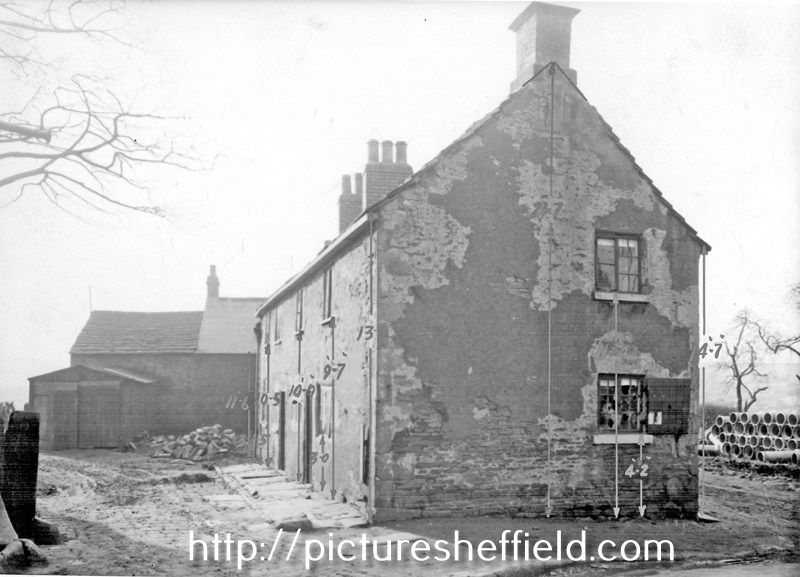
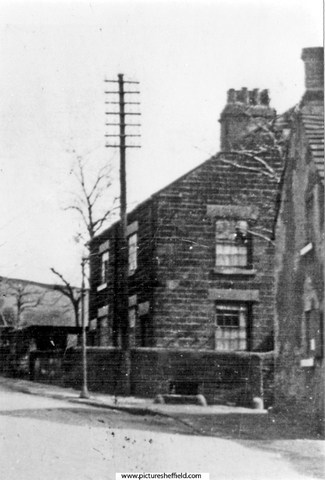
Toad Hole Cottages and Vestry House, Toad Hole Lane (now Southey Green Road), under demolition. u00487 For more details see 'It was all country then' by Sylvia Anginotti, p13-5. Toad Hole Cottages, 5th February 1937.u03089 u03090 Information with photographs: Position 5 (See Plan). Does this information relate to the book by Sylvia Anginotti? Toad Hole Cottages, Occupied the site of Ritz Bingo Hall, Wordsworth Avenue. Photograph shows Vestry House with spring water well by the wall.s11414 School Lane/Toad Hole Lane (now Southey Green Road) looking towards Toad Hole Cottages and Southey Green in the backgrounds00506 Information with the photograph. "Vestry House in the background" Toad Hole Cottages. s11631 Cottages Southey Green, Moonshine Line near the junction with Toad Hole Lane and Southey Lane. u00474 Information from Mick Armitage: Part of the old Southey Village and stood roughly where the current shops stand at the top end of Galsworthy Road just before it joins Moonshine Lane This property is refered to as Deerlands see Sylvia Anginotti's 'It was all country then' Ref: 942.74 SQ p16-18. The maps of the period are more likely for it to be Southey Village.

-
The trough has been in the front garden of a house on Knowle Lane for several years and was much loved and admired. The house was sold a within the past year and the trough disappeared, presumably the owner has taken it with them, I hope so anyway.
-
The site was the eastern end of the Fitzalan Market, which was offices (Fitzalan Chambers) where Tommy Wards' coal sales operation was. After demolition shop premises were built, one of which was Price's Tailors (1928) Ltd (trading as Fifty Shilling Tailors) which opened for business in mid June 1931.
-
I don’t think there was day release in those days.My Dads first job was as a delivery boy with Greggs bakery. He later went on to ESC and did some home study in engineering with ,what I believe was a private fee paying Sheffield based mail order study outfit called Bennet College. My only connection with Owler Lane was with the dreaded school dentist who practiced there on luckless children!