Search the Community
Showing results for 'coal pit lane'.
-

Dixon Lane, bridge over the river.
Ponytail replied to Roger Stevenson's topic in Sheffield History Chat
The Canal Basin measured for the Duke of Norfolk, with the line of Exchange Street plotted, [1817] https://www.picturesheffield.com/frontend.php?keywords=Ref_No_increment;EQUALS;arc04186&pos=50&action=zoom&id=104945 Marked: The Wicker, Blonk Street, Ladys Bridge, weir, River Dun [River Don], intended bridge [Blonk Bridge], Wain Gate, Town Hall, Castle Hill, Castle Street, Castle Folds, Hay Market, Tontine [Tontine Inn], Dixon Lane, Sheaf Bridge, River Sheaf [intended bridge], Broad Steet, hospitals and chapel [Shrewsbury Hospital], shuttle, warehouses, [canal] Basin, Soap House. Plan of Sheffield Castle about 1700 (1706?) drawn in the 1930s https://www.picturesheffield.com/frontend.php?keywords=Ref_No_increment;EQUALS;y09509&pos=56&action=zoom&id=64229 A plan of the House, Croft, etc. near the Hospitals held under the Duke of Norfolk by George Crook, containing in all 3a [acres], 3r [rods], 3p [perches] 1769. https://www.picturesheffield.com/frontend.php?keywords=Ref_No_increment;EQUALS;arc03384&pos=61&action=zoom&id=98620 Land between Broad Street, the River Sheaf and South Street. Crookes [Crook's] Croft, on the west bank of the Sheaf, south of the Shrewsbury Hospital; new Coal Road marked, with acreage taken for it; buildings, summer house and well; acreage of the whole. Coloured, on parchment. (Sheaf Lane, Sheaf Street, Granville Hill, South Street, Shrewsbury Hospital) -
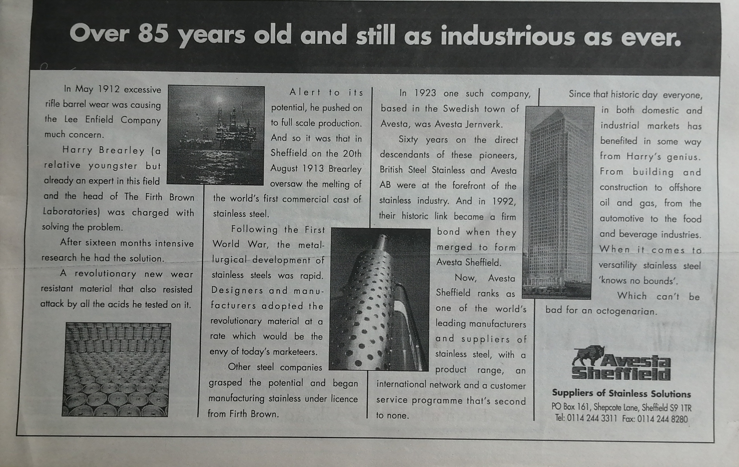
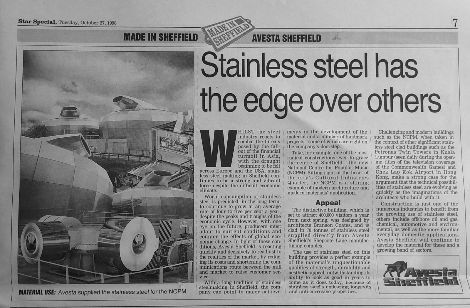
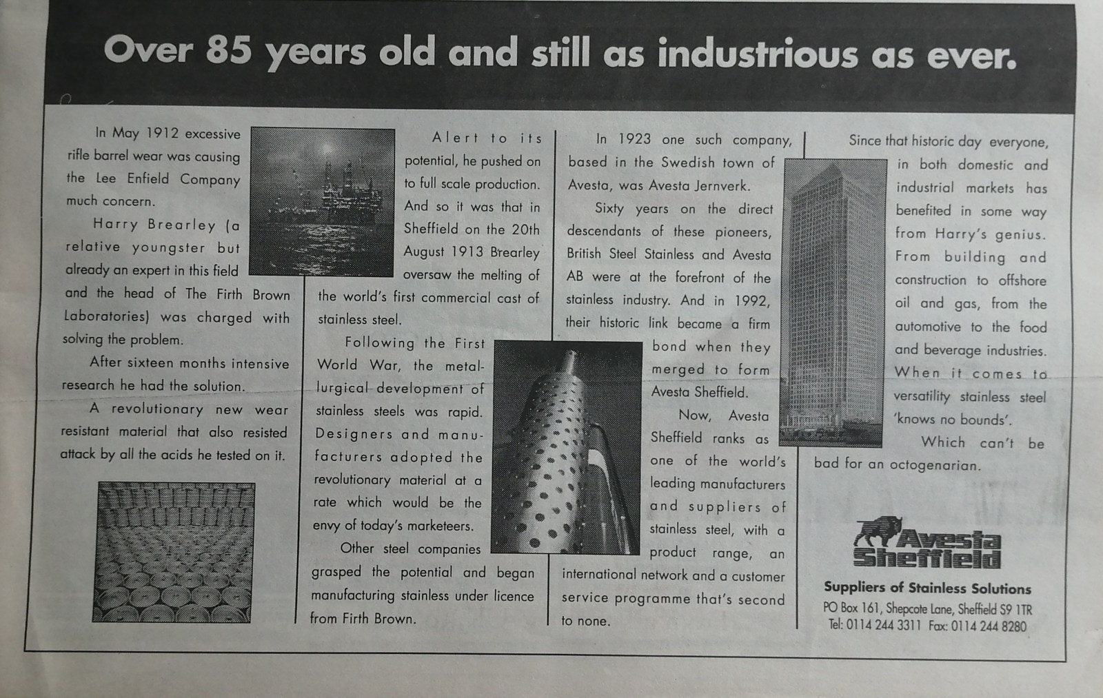
Avesta Sheffield, stainless steel, Shepcote Lane. Article from Star Special, Made in Sheffield, Avesta Sheffield, Tuesday 27th October 1998.
-
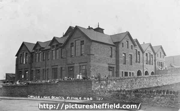
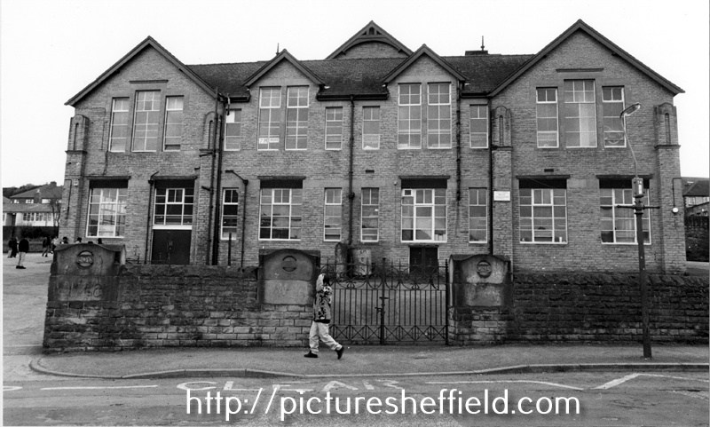
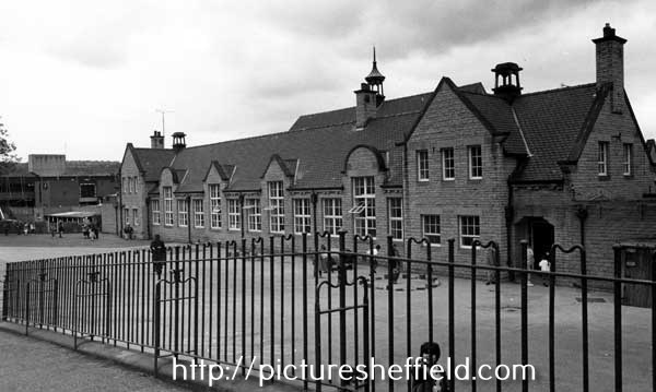
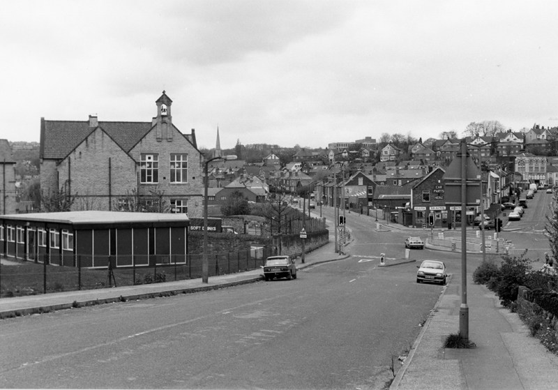
Owler Lane School, Owler Lane. p00100 On this site the original building opened by Rev. J. Gilmore, May 1889; Senior Mixed Department opened by Mr. A.W. Warner, Nov 1901; Infant Department opened by Coun. S. Osborn J.P. Aug 1911. In 1947 re-organised as Secondary (Intermediate), Secondary Modern and Infant School. Secondary (Intermediate) School transferred to Hinde House Comprehensive School 1963. See: City of Sheffield, Education Committee, Handbook of Information, 1964/65. Owler Lane High School (formerly Owler Lane Secondary (Intermediate) School), Owler Lane and the junction with Rushby Street.13th July 1964. https://www.picturesheffield.com/frontend.php?keywords=Ref_No_increment;EQUALS;S24584&pos=18&action=zoom&id=27365 Earl Marshal Campus, formerly Owler Lane Secondary School, Owler Lane showing the old Boys and Girls entrances. 21st April 1993. s24585 Owler Brook Nursery and Infant School formerly Owler Lane County School, Earl Marshall Road. 21st April 1993.s24702 Rushby Street showing Earl Marshall Campus (formerly Owler Lane School) looking towards Owler Lane. 21st April 1993.s26603
-
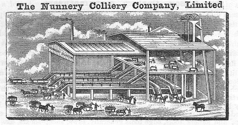
From "The Century's Progress" 1893. For some reason the book is available on a cat enthusiast website, well OCR'd and with engravings. It covers many smaller business's in Sheffield, often in some detail. Link: 1893 The Century's Progress - Yorkshire Unquestionably one of the most important commercial institutions of Sheffield is the Nunnery Colliery Company, Limited, which supplies most of the public institutions of the town with coal, and also, directly or indirectly, provides at least one half of the inhabitants. The business was originally established in 1868. The Nunnery Colliery was formerly the sole property of the Duke of Norfolk, under whom it was worked until seventeen years ago, when a number of capitalists succeeded in converting it into a limited liability company. The managing director is Mr. Emerson Bainbridge, J.P., a gentleman who is well known and held in high estimation throughout a wide commercial circle. Mr. William Black is the secretary. The head offices at Corn Exchange Buildings are handsomely appointed, with a spacious board- room and private rooms for the heads of the several departments. A large clerical staff is provided with all the modern appliances for the rapid transaction of a large amount of commercial correspondence and other business. The Company have a branch office at 58, West Street, and also offices in London. They have also fine depots in Sheffield, which are known respectively as Soap House, in Blast Lane; Salmon Pastures, in Attercliffe Road; Nunnery, in Woodbourn Road and Cricket Road, to all of which the Company have their private line of railways; Manor Pit, within a stone’s throw of the old Manor Castle; Woodthorpe Pit, in Intake Road. There are, likewise, two additional depots, one at Heeley Station, on the Midland Railway, and the other at Wadsley Bridge, on the Manchester, Sheffield, and Lincolnshire Railway. The Nunnery Colliery Company are producing Silkstone and Parkgate coal at the Silkstone, Parkgate, Manor, and Woodthorpe pits, which are all situated in the neighbourhood of Sheffield. The output of these pits is about seventeen hundred tons per day. As they are raising the Silkstone coal at three different pits, they are enabled to guarantee promptitude in the execution of orders for this favourite fuel. They also manufacture upwards of two hundred tons per day of the finest washed steel melting coke, for which they have a large demand in Sheffield for crucible steel melting, where it is held in very high esteem. In the large stables and stable yards of the Company there is accommodation for from eighty to one hundred horses and carts. All these vehicles are in constant use, and the Company are, therefore, able to supply coal direct from the pits to the cellars of their customers. The saving which is thus effected by dispensing with the usual charges for railway carriage and hire of wagons enables the Company to deliver coals at the lowest possible prices. A large amount of money has recently been spent by the Company in providing the most complete mechanical arrangements for thoroughly picking and cleaning the coal. The coal is tipped over vibrating riddles, by means of which the small coal is entirely separated from the large. The large coal is carried slowly by belts into carts and railway trucks, and all impurities are picked out by a number of men and boys placed on the two sides of the belts. The management of this great business in all its departments is most energetic, and all its details, industrial as well as commercial, are constantly under the personal supervision of the managing director and the secretary. The Company contemplate sinking two new pits to the Silkstone and Parkgate seams, in the neighbourhood of Darnell, at an early date, which will very considerably increase the already large output of both house and manufacturing coal.
-
Not sure how these plans help but anything I find mentioning Golden Cross I'll post. A map of a Close belonging to the Duke of Norfolk now subdivided into gardens, and late under Lease with the Golden Cross in Sheffield. 1777. https://www.picturesheffield.com/frontend.php?keywords=Ref_No_increment;EQUALS;arc03127&pos=4&action=zoom&id=98112 The second close as shown in ACM/MAPS/SheS/1532a, now entirely divided into gardens; numerical list with tenants names, descriptions and measurements; both these closes may be seen also on ACM/MAPS/SheS/1534. Shows 'Burying ground of the people called Quakers'. Also shows the proposed route of Garden Street. Original at Sheffield City Archives ref. ACM/MAPS/Shes/1533L. A plan of the Ground and Tenements in Campo Lane the property of the Duke of Norfolk, formerly let with the Golden Cross, containing in all 1,080 yards. 1777. https://www.picturesheffield.com/frontend.php?keywords=Ref_No_increment;EQUALS;arc03117&pos=3&action=zoom&id=98098 Surveyor: William Fairbank II. This plan supplements ACM/MAPS/SheS/1581, showing in detail the tenements at the point later to be the junction of Vicar Lane with Campo Lane; tenants; buildings named. (south side of Campo Lane; Hawley Street, Lee Croft). Original at Sheffield City Archives: ACM/MAPS/SheS/1576s.
-
I went to see The Boss at Bramall Lane back in '88. He played two nights on Friday and Saturday which I think half the city could hear. This video for Spare Parts which was taken from his album Tunnel Of Love was filmed at one or both of the concerts and includes footage taken in & around the Sheffield area: http://www.youtube.com/watch?v=zZgz33m2EMw Enjoy
-
For Reasons Which Will Become Apparent Eventually ...
Ponytail replied to RichardB's topic in Sheffield Genealogy
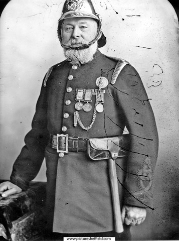
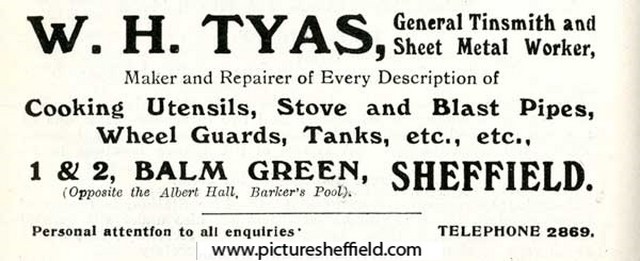
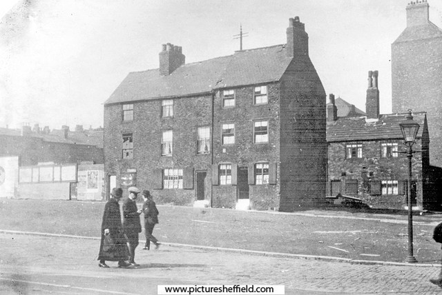
Plan of the corner of Balm Green and Blind Lane, measures taken in Balm Green to fix the line of Division Street where it will pass through the Towns' property; sketch showing the street after the demolition of the old Town property, [1792], 18. https://www.picturesheffield.com/frontend.php?keywords=Ref_No_increment;EQUALS;arc04094&pos=301&action=zoom&id=103509 Three plans pasted together. Shows Division Street, Coalpit Lane, Blind Lane and Balm Green. Tenants / owners marked: Thomas Sayles, Thomas Bennett, John Smith, Edward Brownell, Edward Harrison, Thomas Bennett, Sarah Potter, John Beavans, Timothy Millington, late Sephton, now Thomas Marshall. An outline of the land between Barker's Pool and Church Street, with Brelsforth's Orchards coloured green, 1804. https://www.picturesheffield.com/frontend.php?keywords=Ref_No_increment;EQUALS;arc04039&pos=123&action=zoom&id=103300 Leopold Street, Balm Green, Orchard Lane and Fargate shown (but not labelled). Refers to S. A. Younge, furnace, James Creswick, Jonathan Moor, Malin Gillott and others, Allen and White, Richard Ibberson, Edward Brownell, Christopher Oates, Edward Adamson, Thomas Maxfield and others, Thomas Sayles's freehold, Thomas Bennett, John Smith, Town Land, John Brookes, Sarah Potter, Barkers Pool, John Lindley's freehold, Duke of Norfolk - given in exchange to the To-- [Josep Holland?], George Woollen, William Pavell, Samuel Younge, Rose, Charles Milner, John Jenning, - Webster, William Rowley and tenements and ground proposed to be taken by E? Brook [Brookes?]. Photographs Date Period:1900-1919 Cottages at Balm Green, site of City Hall, on the left are the furnaces of the Queen Steel Works belonging to John Lucas, iron and steel merchant on Holly Street. 1900.s00689 Balm Green, including F. Oldale and Co., joiner and undertaker, No 2 Balm Green. s13218 Fred Oldale (1878-1940) appears on censuses as journeyman joiner until the 1921 census when he is recorded as a joiner and undertaker in the employ of Robert Moss a joiner, builder and undertaker. Robert Moss is listed in Whites 1901 directory at Balm Green as a joiner, builder and undertaker. Balm Green from Holly Street. s19361 Artists Impression of the Cottages at Balm Green, site of City Hall. Entrance to Court No 4, left. Furnaces in the background belong to the Queen Steel Works belonging to John Lucas, iron and steel merchant on Holly Street. 1876.s13220 W. Topsham, Artist. Partly demolished row of buildings known as Pool Place, Barker's Pool (later the site of the City Hall). Former premises include New Music Hall Tavern, No 116, Barker's Pool, on corner. s00243 Shops on Barkers Pool known as Pool Place, prior to demolition in preparation for the War Memorial, note the 'Iron Man' Public lavatory. Holly Street, left. 1923. s00374 Barkers Pool, later site of City Hall, looking towards housing on Balm Green. Houses on right front Court No. 2. 1927.y01592 Balm Green from Division Street. Court No. 4 left (note sign for Robert Moss, joiner and undertaker), Court No 2, right (behind wall)y01403 Photograph shows Grand Hotel in process of building. Balm Green was behind Barkers Pool on site of City Hall. The sign of a joiner and undertaker shows the name R. Moss. Prior to this, Robert Moss, whose residence was at 16 Monmouth Street, owned the Wentworth Temperance Hotel in Holly Street, where the Grand Hotel later stood. Robert Moss had one son and a daughter. He had a lifelong connection with Bethel P.M. Chapel in Cambridge Street and was choir master and Sunday School Secretary for many years. At the Anniverary Services he often entertained the members of the voluntary instrumentalists who accompanied the singing, to dinner and tea between the services at the Wentworth Hotel, being near to the Chapel. John Charles Pound (c.1833-1918), Superintendent of Fire Brigade, c.1870 s08453 Pound was born in Sittingbourne in Kent c.1833. In the 1850s he was a fireman at Lambeth. He relocated to Sheffield c.1870. In the 1880s he was living at Balm Green with his wife and seven children. His first two children were born in Surrey – the remainder in Sheffield. During his time at Sheffield he applied to join Birmingham and Glasgow fire services but presumably was unsuccessful. He resigned from the Sheffield Fire Service in September 1895. He died on 25th October 1918 and was buried in the Sheffield General Cemetery. Advertisement for W. H. Tyas, general tinsmith and sheet metal worker, Nos. 1-2 Balm Green. 1916. y05257 Image from Sheffield Telegraph Year Book 1916 (page 110) (Local Studies 032.74 S).
-
I think some of these may still exist? Fulwood Head Road. Boundary Gleadless Road. Brookhouse Hill. Opposite Cottages & Chapel Green Lane. Near Wood, Walkley Bank Road. Hagg Lane No. 1. Grange Farm (could be Grange Fm at Norton?). New Trough Roper Hill.
-
Thanks for the details…….brought back lots of memories especially of the shops and a few relatives! I have a vague memory of the greengrocer on Stubbin Lane being under a different name for a time before Jim Smith took over. Could that be why there’s no record of J Smith in Kelly’s?
-
Auction of Public Houses, Shops, Farm, Dwellings & Land of William Staniforth
Ponytail replied to Ponytail's topic in Sheffield History Chat
Link to: Building on Carter Hall Lane. https://www.sheffieldhistory.co.uk/forums/topic/19823-building-on-carter-hall-lane/ -
Thanks SteveHB, opposite side of the road I was thinking of. Can you find a J. Smith, either Bellhouse or Stubbin Lane?
-
Styans was on the corner of Bellhouse and Sicey, when it closed didn't it become a greengrocers? I only shopped with mum until I started school in 1956 and ran "messages" under strict instructions after that to certain shops; but have a memory of going into that shop as a greengrocers and thought that was Roses. Apologies Stunmon if my memory is muddled, I was trying to think of a Smiths on Bellhouse Road not on Stubbin Lane.
-
Plan of the Queen's Foundry, Queen Street and premises adjoining in Sheffield. 1842. https://www.picturesheffield.com/frontend.php?keywords=Ref_No_increment;EQUALS;arc04225&pos=4&action=zoom&id=105209 Marked: Model warehouses, stable, stable loft, manure, old warehouse, shed, smiths and joiners shops, foundry, boring and turning mil, engine house, dwelling house, ash pit, privy, reservoir, counting house, fetling shops, sand and core shed, fitting shops, model and lumber rooms, and furnaces. Wardle & Bentham 1814-1815 Iron founders & Masters Darwin & Co., Queens Foundry, Chapeltown, Elsecar & Worsbrough. General & Commercial Directory of Sheffield. 1825. Darwin & Co. mill & engine work in all of its branches, Queens Foundry, Queen Street. White's General Directory 1849. Darwin & Co, New Queen Street, iron founders; stove grate; mill and engine work manufacturers, Queens Foundry, New Queen Street. Thomas Darwin, iron founder & etc. h. 77 Occupation Road. Whites Directory 1852. Darwin & Co. iron founders; stove grate; engine and mill work manufacturers, Queens Foundry, 68 New Queens Street. Thomas Darwin, iron founder & etc. h Handsworth. Whites Directory 1862 Darwin & Co. iron founders & stove Grate & etc manufacturers, Queens Foundry 68 Queens Street. John Darwin, public weighing machine proprietor, 68 New Queen Street. Samuel Darwin, iron founder & Co. (Darwin & Co) h. 8 Hanover Square. Thomas Darwin, iron founder & etc., h. Blenkarn Place, Rock Street. White's Directory 1872 . Darwin & Co. engineers, millwrights, iron founders; general stove grate manufacturers; silversmiths; coppersmiths; tinner brazier tool manufacturers, 98-108 Queen Street. Thomas Darwin, (D & Co) h. 99 Rock Street. Which Queen? Thought it would be Queen Victoria until discovered it was named Queens Foundry earlier. Probably Queen Charlotte wife of George III. Queen, 8th September 1761-17th November 1818. Crowned. 22nd September 1761.
-
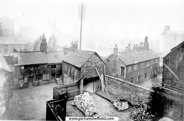
The Cotton Mill replaced an earlier Silk Mill of about 1760 which burned down 1792. After a fire in 1828 the Cotton Mill was converted to Sheffield Workhouse, part of which was utilised as a hospital for the Cholera epidemic 1832 and Sheffield Flood of 1864. William Bower leased the former named Kelham Wheel, building a Silk Mill sited to the south east of the original wheel, taking water through a secondary channel diverging from Kelham head race. Featured on 1771 Town Map of Fairbank and in more detail drawn to accompany the lease of 1773. Only functioning briefly, as Bower was declared bankrupt 1774. Plan of the ground and tenements about the junction of Spring Croft, Bower Spring Lane and the road from the Silk Mill. Surveyor: William Fairbank II. 1783. https://www.picturesheffield.com/frontend.php?keywords=Ref_No_increment;EQUALS;arc03040&pos=1&action=zoom&id=96210 A small lot between Spring Croft and the proposed Back Lane (Love Lane) 1774 the Silk Mill was converted to a Cotton Mill when Wells, Heathfield & Co. took a 21 year lease. Built on either side of the secondary race, incorporating the abandoned cutlers wheel. A valuation survey describes a water wheel 19ft diameter and 21ft wide, producing power adequate enough for 70 cutlers troughs. Fire damaged in 1792 and running again by 1794. The map of 1805 is the rebuilt second mill. Spring Street. Colson Crofts measured for the Duke of Norfolk, including the Cotton Mill, the Steam Engine Grinding Wheel, and T Holy’s land laid out in streets. 1805. https://www.picturesheffield.com/frontend.php?keywords=Ref_No_increment;EQUALS;arc04089&pos=19&action=zoom&id=103413 Shows: Cotton Mill Co., goight to footbridge, Cotton Street, Bower Street, north side of an ancient cut of fish pond, Spring Street, Water Street, Pear Street, Plum Street, Love Street, Engine Street (changed to Steam Street) and steam engine grinding wheels. The Cotton Mill was operated by Water Power until after another fire August 1810 when steam power was introduced. The freehold was sold in 1815, showing there were two Cotton Mills, the steam powered one the Silk Mill site (becoming the Workhouse in 1828) and a smaller water powered mill, converted from the Kelham grinding wheel, also housing a 20hp. Boulton & Watt steam engine. Kelham Wheel reverted to being a grinding wheel. For more information about Kelham Wheel see: "Water Power on the Sheffield Rivers" edited by David Crossley with Jean Cass, Neville Flavell & Colin Turner. Kelham Street. The Cotton Factory, the Cotton Mill (formerly Kelham Wheel) etc. in lots for sale, 1815. https://www.picturesheffield.com/frontend.php?keywords=Ref_No_increment;EQUALS;arc04087&pos=18&action=zoom&id=103381 Shows: Spring Street, Bower Street and Spinning Street. Also marked: engine, boiler, cotton mill (formerly Kelham Wheel), store, wash, nine dwelling houses, large cotton factory, palisades, counting house, two dwelling houses, kitchen, roller shop, iron turners shop, tinner’s shop, turners shop, millwright’s shop, shed, intended engine, gearing room, engine house, intended boiler, boilers, blowing room, warehouses with picking rooms over them, four houses, ten houses. Former offices of Ibbotson Brothers and Co. Ltd., merchants and manufacturers, Globe Steel Works, Alma Street at junction with Cotton Street. 1986. t01080 William Ibbotson founder of Ibbotson Brothers, steel converters, refiners, manufacturers and worldwide merchants built the aptly named Globe Works (Penistone Road) in 1824. The main building was designed to incorporate a domestic residence. The west wing was residential, the east wing counting houses and warehouses. In 1863 he moved to a site on Cross Smithfield before purchasing the former workhouse on Alma Street which he renamed Globe Steel Works. For more information see: Globe Works by Kim Streets (Sheffield Museums), August 1990. Local Studies Ref: 2867 MP. Cotton Mill Walk off Alma Street. 28th April 2007. https://www.picturesheffield.com/frontend.php?keywords=Ref_No_increment;EQUALS;t03223&pos=4&action=zoom&id=33903 Cotton Mill Walk off Alma Street runs down the side of the Fat Cat public house, formerly The Alma. The original cobbled walkway is still visible (2007) and it turns to the right just before the building in the photograph opening up into what would have been the Court which is now a car park for Kelham Island Industrial Museum. Cotton Mill Walk, from the Court entrance looking towards Alma Street with the Fat Cat public house left and the Globe Steel Works in the background. 28th April 2007. https://www.picturesheffield.com/frontend.php?keywords=Ref_No_increment;EQUALS;t03222&pos=3&action=zoom&id=33899 Cotton Mill Row from Alma Street looking towards Bower Street. 1st August 1985. s25356 Cotton Mill Walk https://sheffielder.net/tag/cottonmill-walk/ Hallamshire Historic Buildings. Remains of Sheffield’s first workhouse and only cotton mill – Cotton Street and 24 Alma Street 22/01020/FUL https://www.hhbs.org.uk/2023/01/28/remains-of-sheffields-first-workhouse-and-only-cotton-mill-cotton-street-and-24-alma-street-22-01020-ful/ Sheffield Wire. Plans to convert Kelham Island cotton mill are destroying the historic character of Sheffield, by Oliver Nunn, Feb 20, 2023 https://sheffieldwire.co.uk/index.php/2023/02/20/plans-to-convert-kelham-island-cotton-mill-are-destroying-the-historic-character-of-sheffield/
-
Map showing the position of the Cleakam (Cleakham) Inn, above Green Lane near to Morton Wheel. Not to be confused with Cleakum Inn at Malin Bridge. Plan of lands in dispute between the townships of Sheffield and Nether Hallam describing them as they were in the year 1783 according to a survey thereof made by the late William Fairbank of Sheffield. Dated 1826. https://www.picturesheffield.com/frontend.php?keywords=Ref_No_increment;EQUALS;arc03895&pos=2&action=zoom&id=97344 The ground concerned includes Upperthorp [Upperthorpe], Port Mahon, Nether Thorp [Netherthorpe] and the land between White House Lane (Infirmary Road) and Morton Wheels. Includes John Addy's house, Lidgate Field, Shales Moor Close, White House Lane or Walkley Road, Penistone Turnpike Road, old road from Owlerton to Sheffield, Green lane, Cleakam Inn, Morton Wheel and Morton Wheel Dam, River Dun and Bacon's Island etc. Cornish Street was previously known as Cleakham Wheel Road. A plan of the building lot in Cleakham Wheel Road [Cornish Street] taken of Thomas Shepherd by Henry Ibbotson. 1823. https://www.picturesheffield.com/frontend.php?keywords=Ref_No_increment;EQUALS;arc04196&pos=6&action=zoom&id=105072 Globe Works shown. Sheffield History A-Z Public Houses List: Cleakham Inn, Cornish Place. Open 1800 Closed Span Comments: open circa 1800; 1822 Cleakem Inn, Green Lane 1822 Amelia Facey/Faser/Fraser 1825 Thomas Hobley According to Michael Liversidge in his book "The definitive A-Z listing of Sheffield Public Houses. "...the only known fact was that the landlord was the owner of a bowling green, which was attached to the Cleakham. A Thomas Hobley or Thomas Copley was the landlord in 1839."
-
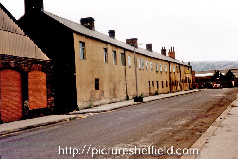
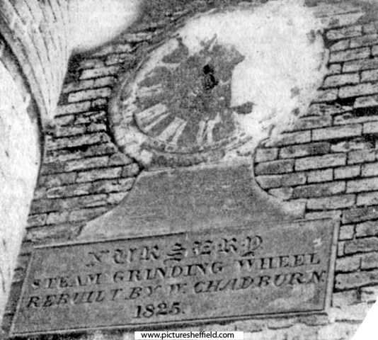
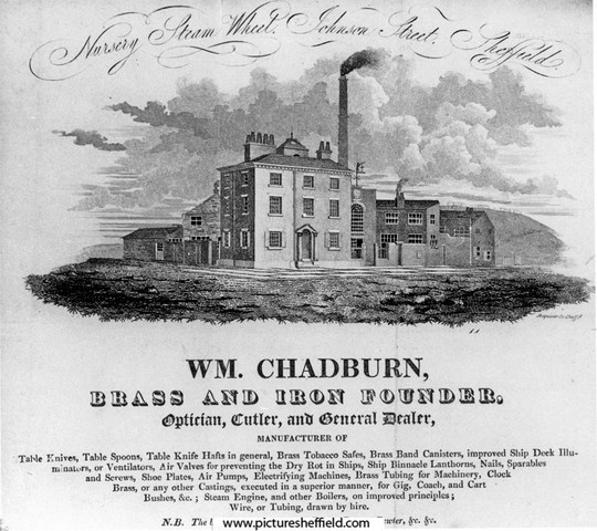
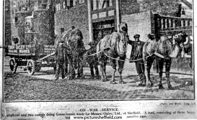
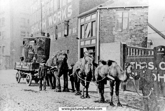
A plan of the Cutler's Steam Grinding Wheel with the small tenements and vacant ground adjoining the same situate in the Nursery, Sheffield. 1822. By John Leather, land surveyor. https://www.picturesheffield.com/frontend.php?keywords=Ref_No_increment;EQUALS;arc04148&pos=10&action=zoom&id=104078 Marked: Spital Hill, Stanley Street, Johnson Street, Andrew Lane, engine yard, smiths sop, boilers, geering [gearing?], engine house, proposed mill, tenement and sough from the river. Nursery Steam Grinding Wheel also known as Shiloh Works. Advertisement for William Chadburn, Brass and Iron Founder, Nursery Steam Wheel, junction of Stanley Street (left) and Johnson Street. Works also known as Shiloh Works. 1828. s10911 Taken from Blackwell's 1828 Directory of Sheffield. Undated newspaper cutting. On the Johnson Street side of the Shiloh Works in Stanley Street, Sheffield is this interesting old tablet. The inscription reads: "Nursery Steam Grinding. Rebuilt by W. Chadburn, 1825." Above there are the remains of a clock dial. s09994 Situated on the Johnson Street side of the Shiloh Works (main entrance off Stanley Street). Refers to William Chadburn, Brass and Iron Founder. Sheffield Flood Claim. Alfred Chadburn, Steam Grinding Wheel Proprietor. Wood Bank, Burngreave Road, Sheffield, for Claim as Owner for damage & loss of rents at the Nursery Steam Grinding Wheel. https://sheffieldfloodclaimsarchive.shu.ac.uk/claimSummary.cfm?claim=1-1210 James Thorpe. horn cutter, Chadburns Wheel, Sheffield living at 36 Fitzallan Street. https://sheffieldfloodclaimsarchive.shu.ac.uk/claimSummary.cfm?claim=4-3629 Henry Palmer, wood turner, Chadburns Wheel, Stanley Street, Sheffield. https://sheffieldfloodclaimsarchive.shu.ac.uk/claimSummary.cfm?claim=6-5046 Sarah Kenworthy, Administratrix of George Kenworthy, late Number 11 Nursery Lane, spinster living at Mr. Chadburn's, Nursery Street; late Number 11 Nursery Lane. https://sheffieldfloodclaimsarchive.shu.ac.uk/claimSummary.cfm?claim=6-5352 Sarah Kenworthy of Nursery Street Administratrix of George Kenworthy late of No.11 Nursery Lane. Claim for the child of late George Kenworthy. https://sheffieldfloodclaimsarchive.shu.ac.uk/claimSummary.cfm?claim=9a-100 The claim suggests George Kenworthy died as a result of the Flood; however he isn't on the list of named dead published in "The Great Flood at Sheffield" Did he die because of complications afterwards or is he an omission to the published list? Employees at Chadburns Wheel, Nursery had their Claim for loss of wages dismissed. John Gormley, spring knife cutler of 8 Bate's Square. https://sheffieldfloodclaimsarchive.shu.ac.uk/claimSummary.cfm?claim=1-1224 John Mason, spring knife cutler of 113 Hammond Street. https://sheffieldfloodclaimsarchive.shu.ac.uk/claimSummary.cfm?claim=1-1227 James Allender, spring knife cutler of 4 Furnace Hill. https://sheffieldfloodclaimsarchive.shu.ac.uk/claimSummary.cfm?claim=1-1228 On War Service for Thomas Oxley Ltd., Shiloh Wheel, Stanley Street. 15th April 1916. s09993 Sheffield Telegraph 15/04/1916 (See also Sheffield Independent for same date) An elephant and two camels doing Government Work for Messrs. Oxley Ltd. of Sheffield. A load consisting of three heavy boilers is being drawn along with comparative ease. Shiloh Works were at Shiloh Wheel also known as Nursery Steam Grinding Wheel see Directory 1919-20. s00065 Thomas Oxley Ltd. https://hawleysheffieldknives.com/n-fulldetails.php?val=o&kel=1319 Stanley Street from Spital Fields, showing old works formerly known as Nursery Steam Grinding Wheel also known as Shiloh Works. Johnson Street in background. 10th June 1943. u02690 Johnson Street from Stanley Street, showing old works formerly known as Nursery Steam Grinding Wheel also known as Shiloh Works. Occupied at time of photograph by Strongs British Twist Drill Ltd & No 27, Johnson Street, Grocers (on left). 10th June 1943. s17536 Photographer: Estate Surveyors Department.

-
Yes, I do remember Bucklows, proper ice cream. I think it closed down completely for a long time after they finished. As a small child I remember the first time going into the shop and she was weighing out sweets from a big jar into the metal weigh pan for a customer and the noise it made has stayed with me all my life. So much so the rare occasions I hear it now I'm transported back to that first time. Crazy how a sound can provoke a memory. I went to primary school with their grand daughter Margaret and we were train bearers together aged about 4 years old for Top Chapel's Sunday School Queen and Captain. Referring back to Jim Smiths, greengrocers, I understand now why I don't remember them, can't remember mum shopping on Stubbin Lane apart from Wilds for eggs up the little alleyway leading up to the Oval. Shopping trip in the 1950's was always "the Meadow", (where I was indulged with a custard cream from the assistant, that was up to being 5 years old) Friedriches, Spencer the butchers, Styans bakers, Wilds and returning up the hill again, the Chemist (always came away with a scented box) Matthews wool shop and finishing off with the Co-op at the top of Bellhouse for the cheese. Up until grandads death Dec 1956 (dad side of the family) we had fresh veg from his garden, afterwards I think mum shopped at the Market in "Town" but on occasion at Roses. Every one of those shops it was a queue to wait in, gossip to be exchanged and as a small child you had to learn patience as there was always conversation with someone in the street as well.
-
The pic of Smiths grocer reminds me of the shop on the corner of Bellhouse Rd. and Shiregreen Lane…near the gated entrance to Concord Park where, in Summer, ice creams and ice lollies were on sale. Can you remember , Ponytail?
-
In the mid / late 1950s I went to FPGS with Roses son, John , a product of Oakwood private school.whom I think became a solicitor..His family ,by my Council house standards, were “posh”( they had a Yacht moored at Bridlington and took part in sailing regattas) and lived in a detached house at Firvale ….next to St. Cuthberts Church.Their shop was definitely at the bottom of Bellhouse Rd…near to Rotherys fish mongers and the Terminus. Jim Smiths ….a much more down to earth character,shop was on Stubbin Lane. His produce tended to be cheaper than Roses…which was why Mum always did her greengrocery shopping there! Whether or not Smiths took over Roses business later, I couldn’t say…by the time I left school I had other things to contend with than shopping with Mum!
-
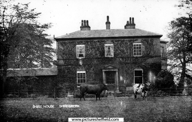
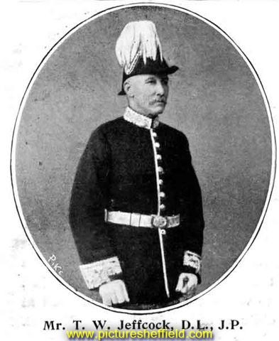
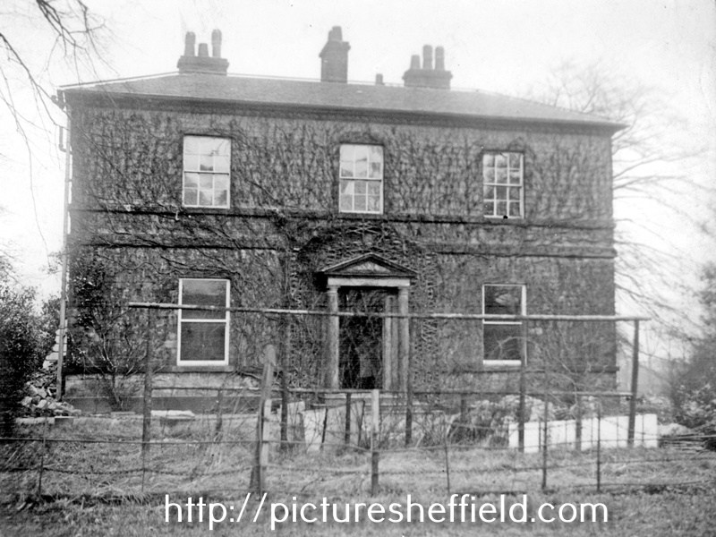
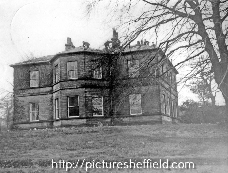
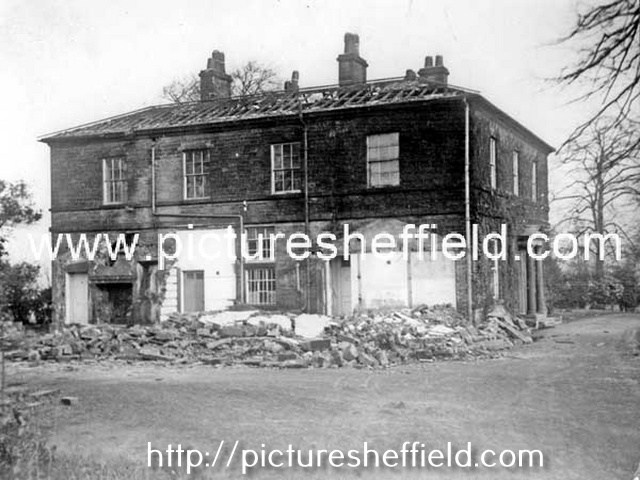
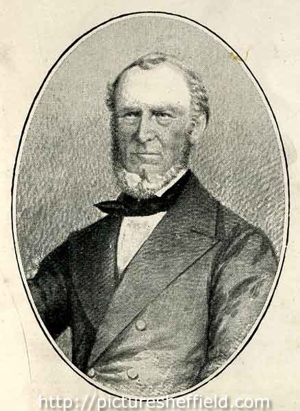
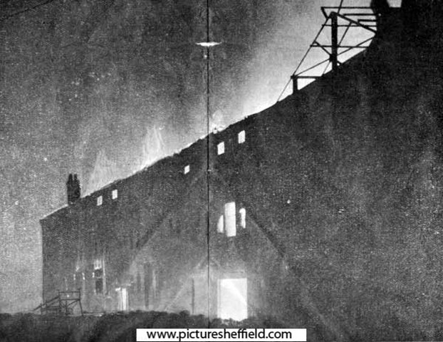
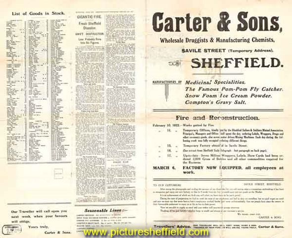
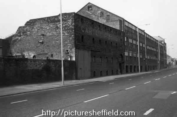
Shire House, Nether Shiregreen. u01160 1910s05982 u01159 Shire House/ Shire Hall, front view. https://www.picturesheffield.com/frontend.php?keywords=Ref_No_increment;EQUALS;v00806&pos=24&action=zoom&id=42608 See also: Sale of superb furniture and choice stock of wine and other valuable effects of Mr. A.A. Hardy dec Wednesday August 5th 1829 Local Studies Sale Catologues Vol 5 Ref: 017.3 S Shire House, (built by Hugh Mellor about 1810, Shiregreen, Wincobank & Ecclesfield, by Brian Wooodriff) isn't mentioned in the 1825 Directory, but there is Andrew Allen Hardy, solicitor and coroner for West Riding of Yorkshire, 19 Bank Street, Sheffield. He had succeeded John Foster of High Green who'd died 4th October 1822 aged 72 years at the Bull & Mouth, Waingate after being taken ill presiding at an inquest. A. A. Hardy held the post until quite suddenly he left the town, leaving large amount of debts unpaid; it was reported he died at Liverpool 20th June 1829, although it was whispered that he was after that date seen alive in America. Thomas Badger, solicitor of Rotherham with offices in High Street Rotherham and Bank Street, Sheffield followed in the role of Coroner, 20th July 1829 after Mr. Hardy's "death." Thomas Badger held the office of Coroner for the next 33 years. Information from the obituary of Thomas Badger, Rotherham Advertiser 2nd August 1862. From White's Directory of 1833 "Shire Green & Nether Shire are neighbouring hamlets 3 miles north of Sheffield and form another seat of the table fork manufacture." In Nether Shire, situated below Nethershire Lane with an entrance off Bellhouse Road, "Shire House a large and pleasant mansion is now the seat of Richard Greaves of Sheaf Works." OS Map 1850. https://maps.nls.uk/view/102345193#zoom=6&lat=4852&lon=14460&layers=BT Richard Greaves died at Shire House, 26th April 1835 aged 55 and buried in the family tomb, Upper Chapel. William Greaves & Sons, Sheaf Works. https://www.hawleysheffieldknives.com/index.php?val=g&kel=1556 Next recorded occupant, 1849 Directory, Capt. Caper, but in 1852 Directory he is recorded as Capt. Capel, staff officer, Shire House. Was he Captain of a Volunteer Brigade, does anybody know anything about him. 1856 Directory the occupant is Henry Hall, Henry, silver plater, Shire House, Shiregreen & Sheffield; Walker & Hall, electro plater & etc. 11 Howard Street. Henry Hall is recorded as a gent, Shire House, 1862 Whites Directory. Henry Hall (c.1802 - 1889), partner of Walker and Hall Ltd. y11266 Image from Walker and Hall, Electro Works Sheffield pamphlet, c.1900 (Sheffield Local Studies Library: 338.4 SST page 11) Walker & Hall Ltd. https://www.hawleysheffieldknives.com/index.php?val=w&kel=367 Change of occupant by the 1879 Directory, Captain Thomas William Jeffcock J.P. (1839-1900) Shire House. Thomas William Jeffcock JP (1839 - 1900), colliery owner, late of Shire House, below Nether Shire Lane, Shiregreen. y08626 For biographical details see 'Sheffield at the Opening of the 20th Century: Contemporary Biographies', S. O. Addy, 1900 (Local Studies 920.04274 SQ 1901 Directory recording "Shire House now unoccupied." Directory 1905, Shire House now in the occupation of James W Dixon. 1911 Directory he had become Major Jas. Willis Dixon. FRGS. Died 1917. James Dixon & Sons Ltd. https://www.hawleysheffieldknives.com/index.php?val=d&kel=372 Link to: Definitely not Victoria most probably. Carter & Sons Glass Bottle. https://www.sheffieldhistory.co.uk/forums/topic/11371-definitely-not-victorian-most-probably/ 1919 see above Sheffield History Link. Geoffrey Cecil Carter, manufacturing chemist (Carter & Sons), Shire House. Former premises of Carter and Sons Ltd., manufacturing chemists, Attercliffe Road. 1987t08420 https://www.picturesheffield.com/frontend.php?keywords=Ref_No_increment;EQUALS;u08477&pos=3&action=zoom&id=90329 Fire at Carter and Sons, wholesale druggist and manufacturing chemists, Attercliffe Road, Sheffield: advertisement for temporary store (at Savile Street) following the fire at the Attercliffe Road store on 10 Feb 1922. y10022 Original at Sheffield Local Studies Library: MP 1705 VL. Carter and Sons, wholesale druggist and manufacturing chemists, Attercliffe Road: on fire at approx. 9.30 pm 19th Feb 1922. y05297 y10023 Demolition of Shire House. u01158 Who was Hugh Mellor, the builder of Shire House? Was there any other occupants? What was the date of demolition.

-
I'm sure Rose's was there in the 1950's but the only "Smiths" I remember was on Bellhouse Road going down to Nethershire. If my memory serves correctly there were 2 brothers so one may have had a shop at Firth Park end. Seem to think one was called Jimmy. Their mother lived next door to us on Bellhouse Road in the 1950's/60's. She had the sweetshop next to Hatfield House Lane I & J School and their dad (named Jim?) not a well man, I think was of retiring age and must have worked for the council because he used to tend the flower beds at the school. Don't think he was ever in the shop trade possibly an ex-steelworker.
-
Hi, I am looking for photos of Water Lane, Sheffield. Preferably around the period 1860 -1900, I would be most grateful for any information. Many Thanks Anthony
-
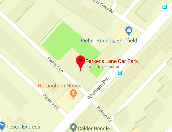
Parker's Lane car park, which is on the corner of Whitham Rd and Parker's Lane, to the right of the Nottingham House pub, also has an area of grass with mini stone terracing for sitting on (I presume). There are also garden gateposts (see pic) with fairly recent railings with inlays which have various items embedded such as open razor, fork etc. Does anyone have any info on all or parts of this site ? If the gates led to a house it would be approximately numbered between 160-140 Whitham Rd. Cheers.
-
can anybody remember the chippy on Lydgate Lane on the cross roads,next to the Hallamshire pub,best fish/chips for miles
-

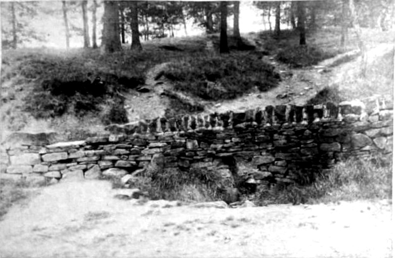
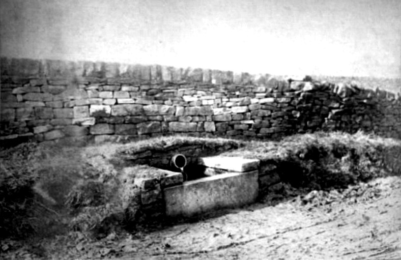
Birley Collieries Branch Line
boginspro replied to Paolo Coopio's topic in Sheffield Buses, Trams and Trains
Great stuff, I walked that line many times, in the 50s/60s, from The Red Hills / Birley West site all the way to Birley East but had totally forgotten about that bridge. This brought back many memories of this area but looking it up now is very disappointing. Back then you could learn a lot from the historic remains easily found by just walking around., A friend of mine still lived in the valley below Birley East Pit. Now what looks like indiscriminate planting of so many trees has masked a lot of the history. If I ever get back there I would love to search for some of the remains that I do remember. -----------------------