Search the Community
Showing results for 'coal pit lane'.
-
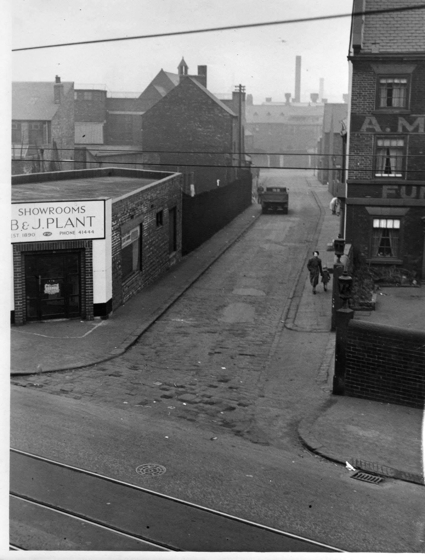
Heppenstall Lane in Attercliffe, Sheffield 1952

-
Hi there folks, could anyone possibly tell me if I'm right on this one please. I'm looking at the 1871 census for head of household, William Bancroft. (His daughter Eliza is my Great Great Grandmother, she married Henry Rolley.) The address is Shude Lane, Forge Yard, Sheffield. I've found Shude Hill and what was Ponds Forge on google maps and on the 1800s map I've found Shude Hill and The Ponds. So, on the 1800s map, would one of the little side streets off Shude Hill be Shude Lane? Also, on Eliza Bancrofts birth certificate, the address is given as Forge Yard, Forge Lane. Sub-district of South Sheffield. Is this roughly all the same place? Thanks for any info or verification. Doris..
-
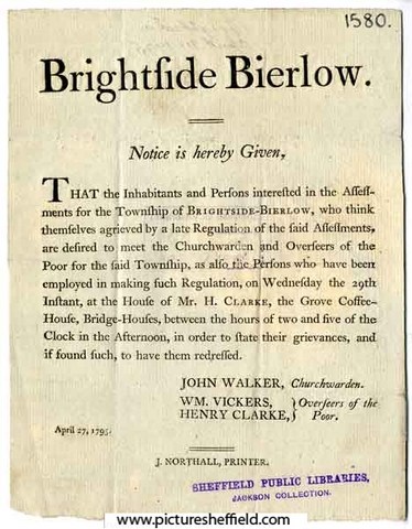
Penny Token of the Overseers of the Poor, 1812. s09460 Obverse shows West View of the Workhouse, Reverse shows Justice, standing with scales, on a pedestal. The Workhouse shown on these tokens was on West Bar. It was opened in 1733 enlarged in 1759, and demolished in 1829. Plan of a proposed Workhouse for Sheffield, between Broad Lane and Trippett Lane, c. 1791. https://www.picturesheffield.com/frontend.php?keywords=Ref_No_increment;EQUALS;arc01855&pos=21&action=zoom&id=71280 Shows work rooms, store room, dining room, laundry, brew house, kitchen, boiling house, bakehouse, oven, pantry, bread room, matrons room, store room, governors room, overseer room, doctors rooms, taylors room, poor attending on overseers [room], sick poor [rooms], bath, cells, etc. Original in Sheffield City Archives: WC/2075M. Notice of a Meeting at the Workhouse on Pitsmoor, in order to make an assessment for the relief of the Poor. 15th November 1794. arc01184 John Walker, Chapelwarden; William Vickers and Henry Clarke, Overseers of the Poor. Printed by Northall, Sheffield. Original at Sheffield Archives (JC/29/42). Notice of a Meeting called to consider the grievances of those people affected by a new Regulation of the Assessments for the Township of Brightside Bierlow. 27th April 1795.arc01185 John Walker, Churchwarden; William Vickers and Henry Clarke, Overseers of the Poor. Printed by Northall, Sheffield. Original at Sheffield Archives (JC/29/43).


-
Came across this list on this site : http://freepages.genealogy.rootsweb.ancest...0.htm#YORKSHIRE Not sure if it has been posted before. My Great Grandad worked at the Brightside pit which he walked into rather than travelling down a shaft - and interesting see no 40 Benjamin Huntsman is down as a mine owner- I assume it is the same one? 1 Aston Main, Sheffield, W. H. Stone. 2 Alumnia, Sheffield, Brooke and Son. 3 Beighton, Sheffield, Skinner and Holford. 4 Birkin, Sheffield, Jos. Bramall and Sons. 5 Bracken Moor, Sheffield, Executors of Jas. Grayson. 6 Brightside, Sheffield, John Denton and Co. 7 Bromley Main, Sheffield, Bromley Silkstone Coal Co. 8 Busk Flat, Sheffield, J. Helliwell. 9 Chapeltown, Sheffield, Newton, Chambers, and Co. 10 Clay Works, Sheffield, C. S. and H. W. Tinker. 11 Clough, Sheffield, Jas. Grayson. 12 Clough, Sheffield, John Gregory. 13 Deepcar, Sheffield, John Armitage and Son. 14 Deepcar, Sheffield, John Grayson, Lowood, and Co. 15 Dungworth, Sheffield, Haigh and Co. 16 Ecclesfield, Sheffield, Haigh and Co. 17 Gleadles, Sheffield, Thos. Ward. 18 Gateshead, Sheffield, Hepworth Fire-Clay Works. 19 Grimesthorpe, Sheffield, John Denton and Co. 20 Hall Park, Sheffield, Charles Marsden. 21 Henholmes(Deepcar), Sheffield, John Armitage and Son. 22 Holly Bush, Sheffield, Joseph Hattersley. 23 Hurlford, Sheffield, John Gregory and Son. 24 Kiveton Park, Sheffield, Kiveton Park Coal Co. 25 Low Ash, Sheffield, Geo. Siddon. 26 Lower Wincobank, Sheffield, J. Johnson. 27 Lowood Wharncliffe, Sheffield, Grayson, Lowood, and Co. 28 Loxey, Sheffield, T. Wragg. 29 Malin Bridge, Sheffield, Grsyson, Lowood, and Co. 30 Manor, Sheffield, Nunnery Colliery Co. 31 Meadow Fire Clay, Sheffield, T. W. Roome. 32 Meadow Hall, Sheffield, Mark Davy. 33 Myers Lane, Sheffield, George Longden and Son. 34 New Winning, Sheffield, Nunnery Colliery Co. 35 North Staveley, Sheffield, Staveley Coal and Iron Co., Limited. 36 Nunnery, Sheffield, Nunnery Colliery Co. 37 Orgreave, Sheffield, Rother Vale Collieries Limited. 38 Potter Hill, Sheffield, H. Law. 39 Shaw House, Sheffield, Benjamin Jackson. 40 Sheffield, Sheffield, Benjamin Huntsman. 41 Stannington Wood, Sheffield, Nichols and Jackson. 42 Starr's Bridge, Sheffield, Marshall and Crapper. 43 Spink Hall, Sheffield, Mrs. Grayson. 44 Spring Wood (Ecclesfield), Sheffield, John Mallison. 45 Stannington, Sheffield, Grayson, Lowood and Co. 46 Stocksbridge (Deepear), Sheffield, Samuel Fox aud Co., Limited. 47 St. Davids (Oughtibridge), Sheffield, Russell and Co. 48 Tankersley, Sheffield, Newton, Chambers, and Co. 49 Thorncliffe,Sheffield, Newton, Chambers, and Co. 50 Unstone Main, Sheffield, Unstone Coal and Coke Co. 51 Unstone, Sheffield, Houdall Coal Co. 52 Vernon Silkstone, Sheffield, Edward Swift. 53 Wharncliffe (Oughtibridge), Sheffield, J. Beaumont. 54 Wharncliffe Wood, Sheffield, Silica Fire Brick Co. 55 Wood, Sheffield, C. S. and H. W. Tinker. 55 Woodthorpe, Sheffield, Nunnery Colliery Co. 57 Wortley Silkstone, Sheffield, Thomas Andrews and Co.
-
A bit of help req! In the May 21st 1850 edition of the Derbyshire Mercury there is a notice advertising the Sale of the Estate of Samuel Shaw of Norton Hall. One of the Many Lots up for Sale is The Lay Rectory of Norton with the Chancel of Norton Parish Church, or such part as belonged to the said Samuel Shaw, thereof and a rent charge of £14 per Annum upon lands in the Parish of Norton in lieu of Rectorial Tythes. Just out of interest can any one explain how this arrangement worked, ie did the Shaws own the Chancel? Also any info on the following Lots in the Sale. A Brick yard with Dwelling House and Brick Kilns thereon at Meadowhead A well frequented Public House at Norton Woodseats A Mansion House called Low Fields House half a mile from Sheffield with Gardens, Pleasure gardens,Vineries,Hot Houses, Stables and Out Buildings. About 13 Acres of Coal in the Township of Coal Aston. Thanks Southside
-
A plan of Hemmingway Farm near Sheffield: the property of the Duke of Norfolk, and now or late under Lease to Isaac Nodder. 1764. Surveyor: William Fairbank II. https://www.picturesheffield.com/frontend.php?keywords=Ref_No_increment;EQUALS;arc03391&pos=213&action=zoom&id=98630 Fields between Cricket Inn Road and (modern Blast Lane), with the wheel and dam (Park Furnace) and part of the Coal-pit sough; Numerical list with field names and descriptions and acreages. Park Furnace and the Simon Wheel (the works on the south side of the River Don from the junction with the Sheaf to modern Leveson Street) (Lumley Street, Sussex Street, Effingham Road, Effingham Street) Also marked: Park Hill; Joseph Clay's Farm; Thomas Bridges's Farm; John Waites's Farm. Does anybody have any information about Hemmingway Farm? Did it have another name? When did it disappear?
-

Birley Collieries Branch Line
Ponytail replied to Paolo Coopio's topic in Sheffield Buses, Trams and Trains
Colliery Engine 'Birley No. 5', most probably at Beighton Colliery Sheffield Coal Co.s15051 Hudswell Clarke 0. 6. 0 ST 'Orient', shunting locomotive built for Birley East Colliery. 1890. https://www.picturesheffield.com/frontend.php?keywords=Ref_No_increment;EQUALS;v00054&pos=32&action=zoom&id=41924 Colliery Engine 'Birley No. 6, Peckett 0. 4. 0 St' and Coal Wagons at Brookhouse Colliery with Water Cooling Tower in the background. 31st March 1938. s15047 Built Bristol 1925 Works No. 1653 Colliery Engine 'Birley No. 6, Peckett 0. 4. 0 St' and Coal Wagons at Brookhouse Colliery. 31st March 1938.s15046 Steam Locomotive W D G Peckett 0. 6. 0 ST at Brookhouse Colliery. 1956. https://www.picturesheffield.com/frontend.php?keywords=Ref_No_increment;EQUALS;v00057&pos=9&action=zoom&id=41927 Steam Locomotive Hudsweel Clarke 0. 6. 0 ST 'Orient' at Brookhouse Colliery. 1956. https://www.picturesheffield.com/frontend.php?keywords=Ref_No_increment;EQUALS;v00055&pos=8&action=zoom&id=41925 Steam locomotive T R G at Brookhouse Colliery. 26th November 1966. https://www.picturesheffield.com/frontend.php?keywords=Ref_No_increment;EQUALS;v00056&pos=2&action=zoom&id=41926 Reminiscences from John A Thickett: 23 November 1966, a Saturday afternoon, saw me loafing beside the ex-Midland Railway line at Beighton. The reason was to see a railway enthusiast's special (in this context meaning an excursion) on its way towards Rotherham. During my wait I was surprised to see activity on a different line, about a quarter of a mile to the south of my position. An anonymous, shining-green tank-engine hauling open waggons was carefully negotiating a steep descent in the Rother Valley (see the white gate visible in s35507). After a while the same engine stormed sure-footedly back with another rake of waggons, this time empty. The waggons all had the initials 'U.C.C.' (United Coke and chemicals) painted in white on their sides. A minute or so later I heard the engine suddenly shut-off, no doubt because at its summit the climb had eased into level ground. These out and back runs occurred several times during my sojourn here. Mr Thickitt watched this activity for several hours from beside the main line railway/Chesterfield Road. Photo Mr. Thickitt refers to s35507 Beighton Castle area in the 1950s View northwards showing, gently curving away through the centre of the photograph, the largely freight-only, ex-Midland Railway Old Road . (The line running between Chesterfield and Rotherham, which was built years before the route through Sheffield city centre). Note this line has four tracks. On the left skyline a viaduct carried the ex-Great Central Railway's Sheffield to Lincoln line over the Old Road and the River Rother. To the right of the line towards Rotherham, the 'North Staveley Curve' leaves eastwards, perhaps still to access North Staveley Pit. On the 1:25000 Ordnance Survey map, surveyed during the 1950s, the line continued eastwards into Brookhouse Pit yard. (This line should not be confused with the out of picture but nearby, ex-Great Central Railway 'Waleswood Curve). The focal point of the scene, an eye-catching, white gate identified the boundary of a private-owner line. In this case operated (in the mid-1960s) by United Coke and Chemicals and leading (along a short, steep ascent) further east to Beighton Coking Plant. (this Beighton site was beside Brookhouse Pit and some distance from Orgreave Coking Plant). Further left, in the mid-ground to the west of the river was the Ex-Great Central Main Line (not visible) with Beighton Station not far ahead. Observe the bridge over the River Rother; a footpath across this had been reassuringly walled-off from the railway track! The river itself shows a vertical deep bank suggesting the Rother had already been canalized and embanked to prevent flooding. These works possibly occurred during the 1950s. Beyond the white gate, the sheet of water was probably a flash , the local name for a pond or lake formed by mining subsidence. Housing puncturing the skyline was on Park Hill, Swallownest. Information from J Thickitt.

-
A plan of 1751 refers to the Mill Dam at Kellam Wheel as Clayton Dam. A map of part of the Close in William Aldam's possession proposed to be taken into the Lane near Clayton Damm containing 166 superficial yards, with the lane, etc adjoining. 1751. https://www.picturesheffield.com/frontend.php?keywords=Ref_No_increment;EQUALS;arc03303&pos=16&action=zoom&id=98496 A simple plan including only the cartway and additions, a footway, a potato-piece and the Butts in Clayton Dam. Kelham / Kellam Wheel, also known as the Clayton Dam; this was on the River Don near Green Lane. Kelham Wheel The name derived from Kellam Homer, the town armourer, who along with George Smedley and John Swyfte were, in 1604 the earliest recorded tenants of the grinding wheel positioned on the head goit to the Town Corn Mill on the land of Earl of Shrewsbury. From the Court Leet of 1609, the tenants of the grinding wheel were required to open the by-pass goit when their wheel wasn't working to ensure a supply of water to the Town Mill. Tenants recorded: 1637; 1641 George Smedley & John Swyfte. 1650 & 1654 recorded as destroyed. 1664-1695, Kellam Homers' son, Kenhelm followed by his wife. 1701 & 1704, Mrs Whatmoore. 1715, James Crawshaw, 21year lease with a rent of £15 had to rebuild the wheel and also ensure the water supply to the Town Corn Mill. A series of repairs from 1712 in the Woodwards accounts suggests major rebuilding. 1736, Walter Briddon on behalf of Johanna Crawshaw. The wheel had two ends of 6 and 5 troughs. Goslings Map 1736 the wheel is shown built across the race. 1758, Mary Briddon was paying £30 rent for 8 and 7 troughs. 1760, William Bower the silk mill builder. The Earl of Surrey’s tenements in Long Croft, Gibraltar [Street] and Bower Springs. 1782 The names of a later date have been added by Josiah Fairbank, and the line of Russell Street and Green Lane, and Bowling Green Street, added. Tenants named. Kelham Wheel marked. https://www.picturesheffield.com/frontend.php?keywords=Ref_No_increment;EQUALS;arc04123&pos=12&action=zoom&id=103838 Spring Street. Colson Crofts measured for the Duke of Norfolk, including the Cotton Mill, the Stream Engine Grinding Wheel, and T Holy’s land laid out in streets, 1805 https://www.picturesheffield.com/frontend.php?keywords=Ref_No_increment;EQUALS;arc04089&pos=6&action=zoom&id=103413 Shows: Cotton Mill Co., goight to footbridge, Cotton Street, Bower Street, north side of an ancient cut of fish pond, Spring Street, Water Street, Pear Street, Plum Street, Love Street, Engine Street (changed to Steam Street) and steam engine grinding wheels. For more information regarding The Silk and Cotton Mill see separate post: "Cotton Mill Co., Cotton Street" Kelham Street. The Cotton Factory, the Cotton Mill (formerly Kelham Wheel) etc in lots for sale, 1815. https://www.picturesheffield.com/frontend.php?keywords=Ref_No_increment;EQUALS;arc04087&pos=11&action=zoom&id=103381 1815, after a fire 1810 the freehold was sold, the larger of the two Cotton Mills became the Workhouse in 1828 and the smaller water powered Mill converted from the Kelham grinding wheel, also housed a 20hp Bolton and Watt steam engine, reverted to its original grinding use. 1822; 1828 & 1833 occupied by John Parkin, pen & pocket knife maker. John Parkin & Company https://hawleysheffieldknives.com/n-fulldetails.php?val=p&kel=2240 1835, 1837/8 Thomas Dunn of Dunn Wheel Co. A plan of a piece of land agreed to be purchased by Messrs Peace of Thomas Dunn. Land at edge of Kelham Wheel, 1837-1844. Shows Kelham Wheel Dam. https://www.picturesheffield.com/frontend.php?keywords=Ref_No_increment;EQUALS;arc03643&pos=9&action=zoom&id=99194 1841 and 1850 Directories record John Pearson, a wood turner and circular sawyer. 1845 Rate Book records Dunn had bought the wheel and it was he as owner who made the Flood Claim in 1864 when the goits were not too seriously damaged. Thomas Dunn, coal owner of Richmond Hill, Sheffield, claimed for damage to Kelham Wheel, Dam & Sluice. https://sheffieldfloodclaimsarchive.shu.ac.uk/claimSummary.cfm?claim=6-5362 After the Flood, the Wheel converted to a Corn Mill and was operated in 1875 by owner James Crossland and William Smith. 1879 White's Directory H & W, Ibbotson, corn millers & corn merchants, Britannia Corn Mills, Alma Street & Corn Exchange. Alma Street. Plan of Kellam Cottage and land adjoining as divided into lots for sale. No date. https://www.picturesheffield.com/frontend.php?keywords=Ref_No_increment;EQUALS;arc04159&pos=14&action=zoom&id=104122 Marked: Marked: River Dun [River Don], Kellam Wheel Goight [Kelham Wheel Goight], Green Lane, shuttles, Kellam Wheel [Kelham Wheel], wash, Kellam Cottage [Kelham Cottage]. Tenants / owners: John Yealdon / Yeadon, John Crowley, Emmanuel Pearson, George Hattersley, James Armitage, William Charles, John Charles, William Charles junior and Henry Travis. Ordnance Survey Map 1890 (294.8.6) shows buildings astride the goit and named Britannia Corn Mills (top of map).The buildings were demolished 1975 but the nine stone piers are still visible. https://www.picturesheffield.com/frontend.php?keywords=Ref_No_increment;EQUALS;q00077&pos=1&action=zoom&id=108114 Water still flows from the shuttles at the head goit into the side race culvert, that formerly fed the silk and cotton mill was still being used for cooling in the rolling mill at Apollo Steels until 1986*. Nothing remains of the main Cotton Mill but traces of ancillary buildings in Globe Steel Works, Alma Street. Kelham tail goit is culverted beneath Alma Street and the outfall to the River Don, Nursery Street. * Information from: "Water Power on the Sheffield Rivers" edited by David Crossley with Jean Cass, Neville Flavell & Colin Turner. W.A. Tyzack and Sons Co. Ltd., Horsemans Works, Alma Street looking across the Mill Race from Kelham Island. t03710 Entrance to Kelham Island showing the rear of the Britannia Corn Mills. t07951 Kelham Island remains of the Britannia Mill and Mill Race. https://www.picturesheffield.com/frontend.php?keywords=Ref_No_increment;EQUALS;u04111&pos=1&action=zoom&id=39621 Redevelopment of Kelham Island showing (background) the Fat Cat public house, No. 23 Alma Street t07955 Renovation work, Kelham Island showing (centre) Woodhead Components Ltd. and the Globe Steel Works, Alma Street. 1987 u12859 u12858 Renovation work, Kelham Island showing (back) Richardson Sheffield Ltd., cutlery manufacturers and Globe Steel Works, Alma Street. t14243 t08050 Renovated bridge, Kelham Island with Kelham Island Museum in background (right) t08039 Kelham Wheel. https://sheffielder.net/tag/kelham-wheel/
-
Hartley Old Pit was started in the 13C, the first records mention it in 1291. It was abandoned in 1844. The Hester pit, aka New Hartley Colliery, (for which I quoted the depth) was then started and reached the low main coal on 29 May 1846. It was a single pit colliery. It was sealed after the disaster of 16 January 1862 and never reopened. In 1874 a new colliery consisting of the Hastings and Melton pits was started nearby which eventually broke into the old workings in 1901. The whole colliery was abandoned in 1959 leaving 70 years of coal below ground. Both Hartley and New Hartley collieries had workings reaching out beneath the North Sea. Thanks for the info on the Sheffield collieries. I've re-read page 20 and can't see a mention of the Watt engine. Page 20 is "Instructions to the Founder" concerning the making of the corf. The description of "The Fire Engine" starts on page 37. Just in case we're looking at different publications, the URL is https://archive.org/details/bim_eighteenth-century_the-coal-viewer-and-eng_1797/page/n19/mode/2up WE both agree that the point of the book is to promote his own designs and inventions, it was the lack of even a passing reference that surprised me, that's all.
-
New Era Square off London Road - what used to be there?
Ponytail replied to Sheffield History's topic in Sheffield History Chat
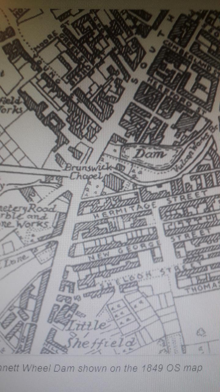
Area around New Era Square in earlier times showing proposed streets. Note some streets changed names. Little Sheffield (London Road) Completed layout of the streets in Rowland Hodgson's land, c. 1818. https://www.picturesheffield.com/frontend.php?keywords=Ref_No_increment;EQUALS;arc04154&pos=17&action=zoom&id=104100 Marked: William Stratford, William Cooper, Samuel Johnson, James Richardson, Samuel Mather, William Staley, Henry Lester, John Reaney, Thomas Burton, Henry Hewitt, John Cadman, Thomas Hounsfield, George Carnall, William Flockton, Catherine Younger, William Staley, Robert Marples, Jackson Frow, Michael Butler, David Craven, William Bunting, John and William Bridgens, Thomas Booker, T. Worstenholme, James Bowen or Bower, Robert Green, William Steadman, John Webster, William Cooper, William Beardstall?, Roger Brown and Sons, Jos. Garlick, George Turton, John Richardson, William Ashall, James Merryweather, George Hall, Jno. Gallimore, Joseph Bower, John Jackson, Joseph Hutchinson, Machin and Hall, Jos. Priest, William Hallewell, Young Sick Society, George Wild, Samuel Rogers, John Wright, William Roper, John Shead, Charles Gallimore, John Mayman, John Hewitt, Robert Walker, Joseph Twells, Joseph Bower, and Jno. Sheldon. Also Marked: River Porter, Little Sheffield; Hermitage Streeet; George Street; Clinton Street. Plan of the late Thomas Booker's leasehold. Properties in the streets between London Road and Brammall Lane (sic) Not dated. https://www.picturesheffield.com/frontend.php?keywords=Ref_No_increment;EQUALS;arc04152&pos=89&action=zoom&id=104092 Shows: Turnpike Road [London Road], Hermitage Street, Clinton Street, George Street, Sheldon Street, Thomas Street, John Street, and Brammall Lane [Bramall Lane]. Refers to the late Rowland Hodgson and the late John Sheldon. Land measured for Rowland Hodgson, with new streets laid out - Hermitage Street, George Street (now Boston Street) and George Lane, 1817. https://www.picturesheffield.com/frontend.php?keywords=Ref_No_increment;EQUALS;arc04153&pos=1&action=zoom&id=104099 Marked: 1 Samuel Newbould, 2 Samuel Johnson, 3 and 4 Thomas Jacklin, 5 Jonathan Crookes, 6 Jonathan Sherwood, 7 William Needham, 8 Thomas Worstenholm, 9 William Brown and George Carnall; also shows William Smith and Rowland Hodgson's gardens; and River Porter. Also: White House Lane (Bramall Lane) Plan of part of the land of the late John Sheldon between George Street and Sheldon Street showing several encroachment. 1843 https://www.picturesheffield.com/frontend.php?keywords=Ref_No_increment;EQUALS;arc04246&pos=95&action=zoom&id=105406 Marked: George Street, Sheldon Street, and Clinton Street; Joseph Prince, William Hallewell, late George Wild now - Webster, late John Wright now Henry Broomhead, late John Sheard? [now?] Michael Butler, Charles Gallimore, John Maynam, and late Mr Sheldon's land. A survey of several closes (in their present state) belonging to the heirs of Samuel Sheldon [London Road] 1791. https://www.picturesheffield.com/frontend.php?keywords=Ref_No_increment;EQUALS;arc03639&pos=31&action=zoom&id=99190 Marked: Turnpike Road from Chesterfield. Plan of a lot of ground in Sheldon Street intended to be taken for a school. 1838. Marked: Sheldon Street; Clinton Street. https://www.picturesheffield.com/frontend.php?keywords=Ref_No_increment;EQUALS;arc03744&pos=11&action=zoom&id=99357 -
Reminiscenses Of Old Sheffield
Ponytail replied to Sheffield History's topic in Sheffield History Chat
Plan of Sugar House, Union Street, Sheffield, the property of Mr Revel. December 1826. https://www.picturesheffield.com/frontend.php?keywords=Ref_No_increment;EQUALS;arc01830&pos=133&action=zoom&id=71183 Improvements in South Street, Coalpit Lane, Balm Green and Hereford Street, with a selection of part of South Street and Jessop Street, 1825. https://www.picturesheffield.com/frontend.php?keywords=Ref_No_increment;EQUALS;arc04251&pos=2&action=zoom&id=105413 Marked: South Street [The Moor], road from Manchester, Younge Street [Young Street], Bennets Lane [Bennett Lane], Hereford Street, [Jail, Fail, Tail Street?], Bright Street, Cumberland [Street], Jessop Street, T. Holy's garden [Holy Green], Earl Street, Rockingham Street, Landers Lane, Duke Street, Carver Street, Ward Street, Porter Lane, Union Street, Sugar House, Furnival Street, Coalpit Lane, Burgess Street, Cross Street, Pinston Street [Pinstone Street], St Paul's, Charles Street, Norfolk Street, Balm Green, Far Gate, an Division Street. A plan of the ground before the front of John Hoole's House [between The Moor and Porter Street] 1796. Surveyor: William Fairbank II. https://www.picturesheffield.com/frontend.php?keywords=Ref_No_increment;EQUALS;arc03494&pos=3&action=zoom&id=98790 Shows Sugar House. Also Marked: Turnpike Road; Porter Lane, Samuel Broomhead Ward; Sugar House not marked on this Plan but used as a point of reference. Plan of John Hoole's tenements near the Sugar House,1788. https://www.picturesheffield.com/frontend.php?keywords=Ref_No_increment;EQUALS;arc03704&pos=4&action=zoom&id=99280 Marked: Little Sheffield Moor West; Porter Lane; Union Lane; a fourteen foot lane; a twenty foot lane; Joseph Swift's leasehold. Probably Joseph Swift was leasing the property known as Sugar House? -
"Dun Street which runs between Shalesmoor and Green Lane is no longer than 100 yards and at one time had no dwellings only public houses: the Bulls Head; the Queens and the Gardeners Rest." An extract from "The definitive A-Z of Sheffield Public Houses" Michael Liversidge (see Bulls Head Hotel entry) Only the Gardeners Rest, Dun Street is marked on Ordnance Survey Map, sheet no. Yorkshire No. 294.7.10. 1890. https://maps.nls.uk/view/231282471#zoom=4&lat=10675&lon=11119&layers=BT Comparing the Plan of Joseph Read's property at Shalesmoor, 1826. and OS Map 1890. The Gardeners Rest is probably the property coloured light blue and marked Joseph Bendelow. https://www.picturesheffield.com/frontend.php?keywords=Ref_No_increment;EQUALS;arc04245&pos=40&action=zoom&id=105405 Plan Marked: Dun Street, Green Lane, Cornish Street, Read Street, Moor Fields. Also: William Hobson, John Sutley, Joseph Bendelow, John Waile [Wale], Thomas Wolstenholme, Joseph Stovin, Ann Jenkinson, James Wolstenholme. There are three "Public Houses" on Dun Street making Sheffield Flood Claims David McFeaden, Inn Keeper, The Queens Hotel, Dun Street, Sheffield. https://sheffieldfloodclaimsarchive.shu.ac.uk/claimSummary.cfm?claim=6-5116 John Frith, Publican,The Cup, Dunn Street. https://sheffieldfloodclaimsarchive.shu.ac.uk/claimSummary.cfm?claim=4-3449 The Cup changed name to the Gardeners Rest. From Sheffield History A-Z Public House List. Cup/Gardeners Rest,13-15 Dun Street. Open.1845 Closed. Span Comments 1919 and 1925 11-15 Dun Street. 1845-46 John Machin 1849 John Machin 1851 - 52 John Machon 1854 John Machon 1856 Edwin Colley 1857 Edwin Colley 1859 Francis Parkin 1862 William H Clark 1863 William Spencer 1864 - 65 John Firth 1868 John Frith [ Cup ] 1871 James Pickard 1876 John Taylor [ Gardeners Rest ] 1879 John Taylor 1881 John Taylor 1883 John Taylor 1887 to 1889 Frederick May [ Gardeners Rest ] 1890 John Adamson [ 17 Dun Street ] 1893 John Adamson 1895 -6 Henry Edwards 1898 William Crampton 1900 John Henry Horry [ 13 -15 Dun Street ] 1901 Albert Thompson born 1852 / Henry Levien (11 to 15 Dun Street) 1902 Harry Levien 1903 Harry Levien 1905 George Henry Lingard 1907 Joseph Clare [ Gardeners Rest ] 1910 John Clare 1911 Lawrence Clare 1912 Lawrence Clare 1913 Frederick A Wittard 1916 -17 Frederick A Wittard 1919 to 1921 Benjamin Wood 1922 to 1924 Mrs Mary J Wood 1925 Samuel L Rooker 1929 John William Corbridge 1931 to 1933 Mrs Florence Corbridge 1936 to 1939 Walter Woollen 1942 Walter Woollen 1944 Walter Woollen 1948 Walter Woollen 1951 Walter Woollen An extract from The Great Flood at Sheffield, 11th-12th March 1864. "In a yard in Dun Street, Green Lane, an old man named Dennis M’Laughlin was drowned in his bed. He lived alone in a room on the ground floor, which was flooded up to the ceiling. In an adjoining room lived the old man's donkey, and there it died by the same calamity which overwhelmed its master. Another family living in the same yard had a narrow escape. They too slept on the ground floor; but they were warned just in time. They rushed out in their night clothes, almost up to their necks in water; but soon reached the house of a neighbour, where they were safe." List of dead. Dennis McLaughlin, age 74 Dun Street. (Was it the Bulls Head Yard?) The Bull's Head. Elizabeth Maskrey, Beerhouse Keeper, Dun Street, Sheffield. https://sheffieldfloodclaimsarchive.shu.ac.uk/claimSummary.cfm?claim=4-3687 Edward Maskrey, saw grinder, Bull Head Yard, Dun Street, Sheffield. https://sheffieldfloodclaimsarchive.shu.ac.uk/claimSummary.cfm?claim=4-3933 Margaret Chatterton, spoon buffer, At Bulls Head, Dun Street, Sheffield. https://sheffieldfloodclaimsarchive.shu.ac.uk/claimSummary.cfm?claim=4-4057 John Horne, labourer, Bull's Head Yard, Dun Street, Sheffield. https://sheffieldfloodclaimsarchive.shu.ac.uk/claimSummary.cfm?claim=4-4246 Thomas Dyson, saw handle maker, Bulls Head Yard, Dun Street, Sheffield https://sheffieldfloodclaimsarchive.shu.ac.uk/claimSummary.cfm?claim=5-4719 Claim on behalf of Ann Elizabeth Driver for "Injury" Annie Elizabeth Driver, servant, Dunn Street, by her Guardian and next friend Elizabeth Maskrey, Beerhouse Keeper, Dunn Street, Sheffield. https://sheffieldfloodclaimsarchive.shu.ac.uk/claimSummary.cfm?claim=9b-165 (Could this also be Bulls Head Yard?) James Trickett, razor grinder, Yard in Dunn Street, Sheffield. https://sheffieldfloodclaimsarchive.shu.ac.uk/claimSummary.cfm?claim=2-1980 From the following photographs, Bull's Head, next to junction with Dun Lane. (opposite the Gardeners Rest?) The Bull's Head public house, No. 18 Dun Street.1986. t01071 It's reported the pub had a rough reputation earning the nickname 'Devil's Kitchen'. Sign appears to read "Old Albion CX? Beers & Stouts" Probably an Old Albion Brewery Pub. Shirley's Wools, former Bull's Head public house, No. 18 Dun Street at the corner of (right) Dun Lane. https://www.picturesheffield.com/frontend.php?keywords=Ref_No_increment;EQUALS;t10227&pos=10&action=zoom&id=90844 No. 13, Shirleys Wools, former Bulls Head Hotel (right), Dun Street looking towards Green Lane Works. 1991.s26227 Dun Lane from Dun Street looking towards Dunfields with former Bulls Head Hotel, left (Shirley's Wools). 1st August 1985.s26229 Also has been the premises of Shalesmoor Upholstery. https://www.picturesheffield.com/frontend.php?keywords=Ref_No_increment;EQUALS;t10291&pos=15&action=zoom&id=91159 Reportedly converted into offices and offered for rent 2003. Bulls Head the property coloured orange and marked, James Parkinson. Building lots in Joseph Read's land, in Dun Street, Read Street and Cornish Street, 1826. https://www.picturesheffield.com/frontend.php?keywords=Ref_No_increment;EQUALS;arc03741&pos=24&action=zoom&id=26564 A smaller scale plan of the plots not marked on FC/P/SheS/1053L. (see arc04345 beginning of this post) Probably the premises of the Bull's Head marked James Parkinson Moorfields. Plan of the ground between Green Lane and Gibraltar. 1824. By John Leather, land surveyor. https://www.picturesheffield.com/frontend.php?keywords=Ref_No_increment;EQUALS;arc04168&pos=32&action=zoom&id=104372 Shows Green Lane, Dun Street, New Street [Dun Fields or Acorn Street], Ebenezer Square, Ebenezer Chapel, Bowling Green Street, Hunters Lane, Ebenezer Street, Spring Street, Cotton Mill Walk, Lancasterian School, Gibraltar, Chapel Street, Moor Fields [Moorfields], school, Allen Street, Holmes Lane. Owners / tenants marked: Abraham Ibbotson, Thomas Cornshaw, James Parkinson, Richard Holmes, John Brown, James Jenkinson, Richard Holmes, and Joshua Fowler. From Sheffield History A-Z Public Houses List: Bull's Head, 18 Dun Street, S3 Open. 1851 Closed. Span. 1859 Elizabeth Maskrey 1889 Mrs Sarah Furniss 1891 James Furniss 1901 Joseph Buttery [ census born 1873 ] 1937 Byron Arthur Yates 1938 Alice Lynden 1939 Mrs Alice Lynden 1942 Alice Lynden 1944 John Haley 1948 George C Mannion 1951 Arthur Sawdon. ___________ Queen's / Queen's Head (Queens Head Hotel) 37 Dun Street, S3. Open. 1825 Closed. 1970 Span. 145 1841 William Walker 1871 George Walker (Beerhouse) 1876 George Walker 1889 John Cole [beerhouse] 1900 Frank Naylor [beerhouse] 1901 Frank Naylor [census born 1866 ] 1912 Frank Naylor 1937 Mrs Florence Anderson [beer retailer only] 1938 Mrs Florence Anderson [Queen's Head] 1939 John H Johnson [Queen's Head] 1842 Horace McMullen [Queen's Head] 1944 Henry Lewin [Queen's Head] 1948 Henry Lewin [beer retailer only] 1951 Mrs Grace Lewin 1958 Brian Salmons to 1968 Brian Salmons Information Received by email from Brian Salmons. I was thrilled to see the Queen's at 37 Dun Street, Shalesmoor listed on your website http://www.sheffield...733 My father and mum (Mr Brian Salmons and Mrs Kathleen Salmons) were tenents of this Whitbread pub from the late 50s until 1965 and I grew up there. As I remember it was actually called the Queens Hotel and only opened in the evenings on weekdays. Best regards, Brian. Further information Thanks for your mail. I know for certain is that we moved out in March 1965. I was born in 1958 and they were already at 37 Dun Street then.They were married in 1956 and lived for a few months with Dad's mum before moving to the Queens so I am sure they did not take over from Mrs Gracie Lewin. When we were there it was a Whitbread pub and we used to go to the Brewery HQ on Lady's bridge. I recall it was the Queen's Hotel and remember we had lodgers.
-
The following extract reveals how some Sheffielders had "Gardens" not always attached to their dwelling but a separate garden in the suburbs where they enjoyed relief from their work and grew flowers and produce to feed their families but sadly, were gradually being destroyed as Sheffield expanded in the middle part of the 1800's. Extracted from Reminiscences of old Sheffield, it's streets and it's people. edited 1875 by R. E. Leader from articles and Letters from The Sheffield and Rotherham Independent 1872/3. Page 145-153. CHAPTER VII. Old Sheffield Gardens. Present — Messrs. Twiss, Leighton, Everard, Wragg, Leonard and Johnson. Period— A.D. 1873. We were all sitting, one charming and warm evening, in the cosy summer-house of our friend Twiss. It was not in the garden attached to his residence, for he dwelt in the recesses of a dingy town, with a melancholy grave-yard for his outlook. But he was old-fashioned enough and wise enough to stick to the traditional Hallamshire custom of keeping a small garden-plot out in the suburbs, to which he could retire in the intervals from business, in which he could delight his horticultural soul, and, above all, which gave him an object for a walk after the toils of the day. It was a treat to see him in the fading twilight of a summer night, wending his way back to his sooty brick dwelling, laden with rural spoils, with which to enliven it — a huge "posy" of lupines and sweet-williams, and pinks, of cabbage-roses and pansies, and other good old English flowers, now despised and rejected, in obedience to the "bedding out" mania, for masses of scarlet geraniums and yellow calceolarias. Nor was he above bearing through the crowded streets products of even a humbler kind — big-headed cauliflowers or juicy lettuces, or largehearted cabbages — or some other palatable form of the much embracing genus "greens." Of course, being in the country — so to speak, though we were by no means out of the reach or out of sight of the smoke — our talk was of country things. One told how his grandfather, a great garden-smith, used to delight to get away from his shop to his little plot down Bramall Lane way — a walk among the hedges and through pleasant shady lanes; and another remembered being sent, in 1825, with a message to Montgomery, who had retired from his sanctum upstairs in the dingy Hartshead— over the coal place, and with depressing outlook on to brick walls and dilapidated roofs — to refresh himself for a time among the polyanthuses and daffodils of his garden, between Glossop Road and Leavygreave. That is where Hounsfield Road is now, for most of the space from Glossop Road to Brook Hill, belonging to the Water Company, was divided into these little plots. The town in those days was literally surrounded with groups of neatly-partitioned gardens. The late Mr. Edward Baines (M.P. for Leeds from 1834 to 1841) was accustomed to remark that the multitude of small, nicely-kept gardens in its suburbs was a characteristic of Sheffield, in which it was in advance of any other large town he knew. Look which way you would, or go in what direction you would, there they were. Besides the celebrated gardens in the neighbourhood of Hanover Street, there were similar gardens higher up Broomspring Lane and Wilkinson Street, and on the site of the Baptist Church on Glossop Road, and up to Northumberland road and opposite Mushroom Hall to Westbourne, Mr. Cadman's house, near which are a few remaining. From Glossop Road the Water Company's land extended into Brook Hill, and the gardens on this piece were always considered some of the best in the town. Near to and behind the late Ald. Saunders' house in Brook Hill, were gardens, behind which were others, reaching down by Brightmore Street, Bellefield Street, Portmahon, Bedford Street, and Waterloo Houses (commenced building by the father of James Levick, the dahlia grower, and finished by his mother), to the River Don. Then on the opposite side of the river, the site of Neepsend brewery, and right up to the wood and Woodside Lane; also on the opposite side of Woodside Lane, under Pye Bank, to the mouth of the railway tunnel. Harvest Lane, and Green Lane to Colson Crofts were occupied in a similar way; and another plot of small gardens is now on the site of the old Midland Station in the Wicker. These as originally intended, were to have been the basin of the Sheffield Canal. On the opposite side of the road, between Twelve o' Clock Wheel, or the Albion Ironworks, and the Norfolk Bridge, was another lot of gardens, destroyed about 25 years ago. There were small gardens in the Park, part of which is St. John's churchyard. There were some others at Skye Edge, down to Duke Street, or the Intake road. At the end of Clough Lane, down to the river Sheaf (Sheaf Gardens), were gardens considered second to none in the neighbourhood, some containing good double houses, not like those in Club Gardens, Sharrow Lane. From these were others extending across Suffolk Road, down to Harmer Lane. There were also the gardens just destroyed at the end of Bramall Lane, opposite Sheaf House, on the path to Highfield; and about 25 years ago was destroyed a plot of gardens that had extended from the top of Young Street to Broomhall Street. There were some others that have disappeared, to make room for buildings about the General Cemetery and Broomhall Mill. "When all the above gardens were in existence," said Mr. Wragg, "I believe one out of every three working men had a garden, which he cultivated more for pleasure than profit. This was far better than his present gambling propensities; but further, there were not a few instances in which the working man's garden assisted him to clothe his family, or to pay off debts, unavoidably contracted, by the sale of the fruit from his pear or apple trees. Now, there are no such places for a working man to resort to in his spare time, except for those who are members of some Land Society outside the town. It is said he may resort to the Library, or peruse his book at home; that he can amuse himself by holding communication with the great men of past ages; but all such talk is a delusion. Bodily toil and mental discipline will not go hand in hand, or blend. The garden plots remaining are, alas, but few; they may be almost counted on the fingers of one hand, some under the wood at Hillfoot, and some in Neepsend Lane to the river; the Water Company's piece, Hanging bank, and in the flat below the site of the old dams, commonly called Upper and Lower Canada; some around Younge's Silver Rolling Mill; some, comparatively speaking recently made, between Hyde Park and the Manor. There are a few left in Ecclesall Road. In Sharrow Lane are the Club Gardens, that have always been remarkable for the number of houses occupied by the tenants. Fenton Ville gardens and South View gardens, extending down into the Abbeydale road, are noted for the number of their florists, the most successful of whom is William Allsebrook, famous for rearing new kinds of polyanthuses. I am sorry to say I believe all these gardens will soon be like the others mentioned — demolished." Leonard: Yes, they are fast being engulphed by the omnivorous builders; and the robberies to which they are exposed are a great discouragement to the enthusiastic amateurs who compete at pink shows, or dahlia contests, or who strive to raise gigantic gooseberries, to be weighed at Florists' Inns, and celebrated with a supper. Let us hope that this annihilation of garden allotments does not indicate that the healthy delight in floriculture that has always been a characteristic of Hallamshire is dying out. You may still see the grinder returning from a pop visit to his little country delight, laden with early spring rhubarb, or with roots of celery, according to the season of the year; and freehold building societies have altered life so much as to give working men an opportunity of having their homes standing in their own gardens, which is not only healthier but handier. A member of our company mentioned the splendid bed of ranunculuses which a resident in one of the houses still standing opposite the top of Broomhall Street, used to show, and reminded us of the celebrated garden which the Staniforths, father and son, the eminent surgeons in Castle Street, had in the Grimesthorpe road, the present Gardeners' Arms being their garden house. Mr. Wragg recalled that kind, genial old man, Edward Middleton, baker, who kept the Barleycorn Tavern, in Coalpit Lane — the most obliging of neighbours among amateur gardeners. The vicinity of Hanover Street used to be marked out like a chess board by these gardens, and Middleton had one, near the corner of Broomspring Lane and Hanover Street. The top part of it forms now part of Hanover Street, and the bottom extended behind the houses of Mr. Owen, the draper, which face to Broomspring Lane. Afterwards, he showed his skill in one of those previously spoken of, on Glossop Road — where Charles Thompson's coach premises are now, then belonging to the Water Company — having gone there by reason of his neighbour, John Burton, the Quaker, buying a garden for him. Mr. Wragg believed that the last possessor of Middleton's garden, near Mr. Owen's houses, was the late Mr. Bennett, grocer, Church Street, elder brother of the present Mr. Bennett, who succeeded him in his business. Joshua Wilkinson had the next garden above, and he sold it to William Melluish, the last survivor among the many South Devon Militiamen who settled in Sheffield after the disbanding of the regiment. The garden above was Mr. Swift's, the father of Mr. G. E. Swift, in the steel trade, in Blonk Street. At the front of Spring Lane was Samuel Padley's (a Quaker), the father of Mr. Padley, of the firm of Padley, Parkin, & Co., silversmiths, in Watson's Walk. The late Mr. Bramhall, one of the managers of Messrs. Rodgers and Sons, and Mr. Staniforth, grocer, of Broad Lane, had gardens hereabouts. Mr. Roger Brown was the last who had Mr. Staniforth's. Just below, and behind Josh. Ingle's house, an old woman of the name of Savage had a garden, and did all the gardening herself. The late Mr. B. Hinchcliffe had a garden in this piece, and there is a tradition that the late Mr. John Holland occupied a garden here, but his nearest friends are incredulous about it. The story is that an old man, a relative, did the gardening for him, in which case it may possibly have been his uncle Amos. A file cutter, afterwards a silver stamper, named William Hague, had the first garden opposite old Mrs. Savage's. Being a frugal man he saved money, by means of which he built the houses at the bottom of Broomspring Lane, and opened a grocer's shop at the corner. The last person who had Mr. Hague's garden was Mr. Worth, the joiner and builder. Mr. Turner, the Sheriff's officer in Campo Lane, had also a garden; so had Mr. Taylor, of the Commercial Inn, Haymarket, now destroyed by the making of the new street into Norfolk Street; and Mr. Theaker just by, for many years the only coffee-house keeper in the town, had two up to the time of their destruction. James Levick, the ivory merchant, of Pinstone Street, was a well-known dahlia grower. He raised from seed a dahlia which was named "Levick's Incomparable," the beauty of which was that the petals were tipped with white in so peculiar a manner that many persons supposed they were subjected to some chemical process. But this peculiarity was not at all of regular occurrence; and many growers, disappointed by obtaining flowers without the white tips, poured out their woes in the "Floricultural Cabinet," then published by Mr. Ridge, in King Street, and conducted by Mr. Harrison, Lord Wharncliffe's gardener. They besought Mr. Levick to give them details of cultivation, and in reply, he could only say that the flowering was very eccentric, sometimes he produced the flowers with tips and sometimes without; and Mr. Paxton, having one year obtained most beautifully tipped blooms, set a large quantity the next year in most conspicuous places, and had not a single bloom tipped. The secret seemed to be to check a too luxuriant growth of the plant. Mr. Levick also produced a handsome crimson dahlia — "Commander-in-Chief" — which was honoured with a coloured engraving in the work named. Mr. Thomas Tyson, who kept the "Fountain," in Coalpit Lane, was a distinguished florist, and a man evidently much respected by his brethren, for "his funeral was attended by the florists of the town, who strewed his coffin with a profusion of most beautiful flowers." Club Gardens, as has been said, were remarkable for the number of the houses occupied by the tenants. In one house resided the late Mr. Paul Smith, a well-to-do-man, said to have been worth six or eight thousand pounds ; but he was induced to enter into partnership with some firm which shortly afterwards failed. The creditors seized all the property of Mr. Smith to pay the debts of the firm, so he became a poor man, and died a recipient of the Iron and Hardware Pensions. Another resident in these gardens was the late Mr. Charles Unwin, of Westbar, the broker. Previously he had a garden in Brook Hill, in the piece behind Mr. Brightmore's house. After the death of Mr. Thomas Nowill, Mr. Unwin bought his garden, and there he resided at the time of his disastrous fire, in which some thousands of pounds worth of his property and stock-in-trade was destroyed. It gave such a shock to his nervous system that soon after he died, about 16 or 18 years ago. Mr. Unwin was a native of Anston, and originally was a labouring man; but he turned sawyer, and was a very hard worker. Another native of Anston was the late Mr. Henry Broomhead, the solicitor, whose father was a tanner. Some of the best gardens in the neighbourhood were the Sheaf Gardens. About thirty years ago the late Mr. William Stratford had a garden that was remarkable for the neat manner in which it was kept by Mr. Stratford himself; and his tulip bed was the admiration of all beholders. Hanging Bank Gardens, when in existence, were notable for the number of those tenants who exhibited gooseberries at shows ("berry showers") the chief of whom, and the most successful, was the late Robert Green. He resided in one of the houses, probably built by himself or a former tenant, since it is not the work of a mason. He had another garden lower down, but one or two others intervened, and up a walk nearer where the stream of water ran from the Water Company's dams. From his success as an exhibitor of goose-berries he obtained many copper kettles as prizes. When the time of exhibiting was about to take place, his garden had to be watched from the Saturday night to Monday morning to prevent his trees being stripped. Green was a spring-knife cutler, and worked for the late Mr. B. Micklethwaite, whose workmen were very respectable, honourable, and upright. Amongst them there were none of the coarse jokes, indecent conversation, or unmeaning, empty, and profane jests, so common among workmen in the workshops of the present day. They talked when they had something to say, and years after, when one would casually meet another in the street it was always with kindness and respect, something like one gentleman meeting another. About 40 years ago, in one of the gardens near what is now the top of Fawcett Street, just before Bellefield house, was a whitewashed house, with sash windows, in which resided the late John Milner, who in his day was said to have been one of the best, if not the best spring-knife cutler in the trade, and notable for his great powers of debate. He was born in Spring Street or the immediate vicinity, and in his youth or childhood was a companion of the late Mr. Wm. Stratford. He was the last survivor of his early associates. When John Milner left the house it was not afterwards occupied. It dwindled away — lads first broke the windows, and next it gradually disappeared. In Watery Lane was a very good house standing back in a garden. For some time it was unoccupied, and from being untenanted it got into a dilapidated condition. A few* years ago, a portion of one of its walls fell on some children, and one of them was killed. The last occupier was a person of the name of Ross, who left the town and afterwards died. Ross was a man who was going to get every one his fortune. People who believed they or their ancestors had been deprived or dispossessed of property flocked to him in crowds. Somewhere in the vicinity Ross had a rival, a woman, who had two strings to her bow, for in addition to being a fortune-hunter she was a fortune-teller. The market gardeners' grounds ranged, for the most part, from Neepsend and the Old Park Wood to Hall Carr. There was George Stubbing, whose garden, kept before him by Mr. Thornhill, who had a cook shop in the Hartshead, extended from Woodside Lane to Old Park Wood, being bounded on the north by Cook Wood. Part of his garden in Harvest Lane is now the depot of the Board of Health, while the southern part, including the site of the original house, was taken for the Manchester Railway. Before beginning a garden on his own account, Mr. Stubbing had been in the service of Dr. Webb, of whose garden in Harvest Lane he had charge. There was James Andrews, who had an orchard at Neepsend, where the Neepsend Nursery now is; and the orchard in Harvest Lane of William Burgin, now displaced by the various works in Mowbray Street, was one of the finest sights in the town in spring time. Who does not remember, too, that other orchard on the slope below Burn Greave, which everybody would stop and admire even so late as 1855-60? There were two other Burgins besides William, but he was not related to them. They were brothers, George and Jonathan. The former was the last inhabitant of the Clay's house, in Bridgehouses; the latter had a fruit shop in Bower Spring. From Pitsmoor Church to Burn Greave, and to where the Railway crosses Tom Cross Lane, market gardeners had their grounds, and a pleasant walk it was through them, for the Burngreave Road and Rock Street were not made then. The orchard and grounds between these two roads, where Catherine Street now is, were occupied long ago by John Pearson. His family were table-knife cutlers at Neepsend, but he was fonder of gardening than cutlering. Afterwards the land was in the hands of Mr. John Garnett for many years. Then it got into Chancery and was in a lost-looking state until it was built upon. Mr. Garnett removed to the land between the Wicker Congregational Church and Carlisle street, Gower Street having been made across it near to where what was his house still stands. Gardens of similar kind extended to Hall Carr Lane, where, not many years ago, gypsies might sometimes be seen. On the other side of the town was Mr. Hatfield's nursery, on the Glossop road, adjoining Wesley College, which often attracted passers by its beauty. From gardens and gardening we got to talk generally of the changes that have taken place in what may be called the nearer suburban surroundings of the town. The youngest member of our friendly group could, we found, call to mind surprising changes; as for the eldest, the wondrous transmutations to which he could bear witness were endless. Within a very small radius of the Parish Church — say Carver Street Chapel — he had walked in green fields, or traversed woods whose sites are now occupied by whole colonies of houses, and it was told how tradition affirmed that a resident at the top of Coalpit Lane had shown his children Judge Wilkinson's stacks burning at Broomhall from the field on which Carver Street Chapel now stands, then called "Cadman's-in-the-fields." That was in 1791; a more recent story was that in 1817, two ears of wheat were plucked in a field at Roscoe Place, each seven inches long. One of them contained 69 and the other 70 corns. Our old friend's description of Broomhall Spring, which he remembered when he was about 10 years old — in 1791 — was very interesting. "I very well remember," said he, "coming with my father through the wood called Broomhall Spring. It extended from about Wilkinson Street to Broomhall Park. It was full of very fine oak trees, with very little underwood, and the turf was soft like that of a park. I remember very well seeing the trees and the grass, and the sunlight gleaming among them. Not long afterwards the wood was cut down. The Government was then wanting a great deal of oak timber for ship-building, and the trees in Broomhall Spring were sold for that purpose. The roots were dug up, and the land turned into the gardens of which we have been speaking." The inscription on the stone over the trough was still there up to 1836. It ran: — "Spring Garden Well. To the public use, by the Rev. James Wilkinson and Philip Gell, Esq. Freely take — freely communicate — thank God," its site is now enclosed in the garden of the house at the corner of Gell Street and Conway Street.
-
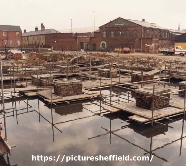
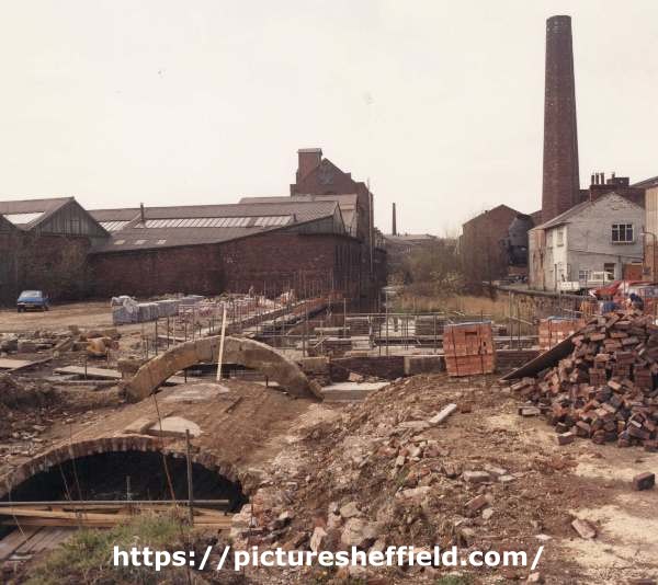
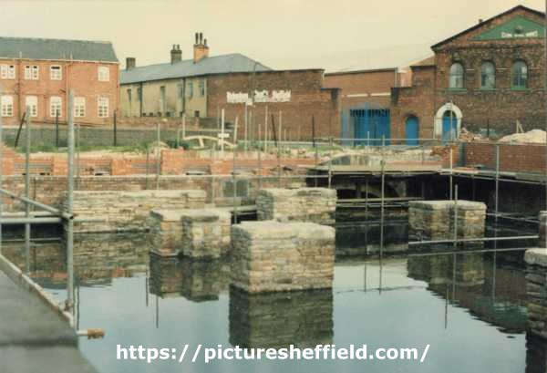
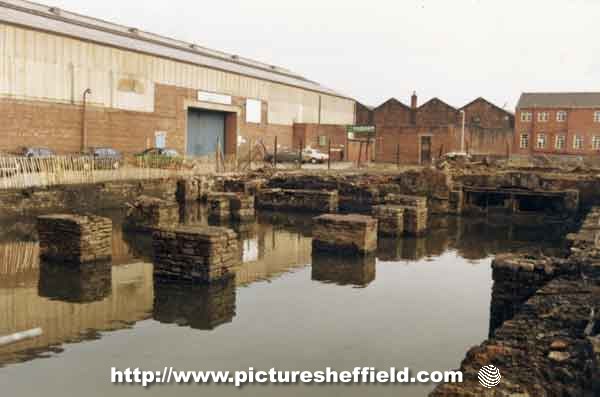
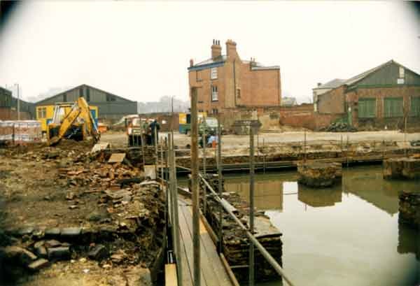
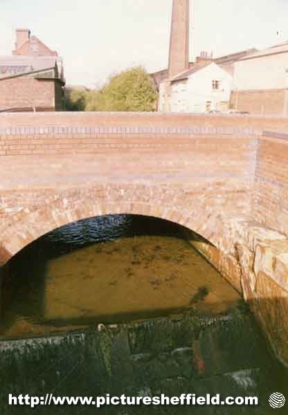
I attach a screen shot of the 1849 Ordnance Survey map of part of the city centre. I'm looking at the history of the Porter Brook in the area. I've walked through the culverted parts a few times and there is a lovely stone arch bridge/tunnel between the Decathlon car park and the former Staples car park. The latter entrance is visible through a clump of trees. I think from the 1849 map that this is the two centuries old, and still intact, Vulcan Works Bridge (Vulcan Works was certainly on the site at the old Staples car park end). It is best part of 100 yards long and the Ordnance survey map shows it to be of some length (Hereford St did, and still does, run over the top). Any info/dates of Vulcan works and/or better map links greatly appreciated
-
The Brown Cow Public House in Red Croft, measured for Rawson and Co. 1815. https://www.picturesheffield.com/frontend.php?keywords=Ref_No_increment;EQUALS;arc03718&pos=1&action=zoom&id=99298 The Brown Cow measured for T Rawson and Co., [1832] https://www.picturesheffield.com/frontend.php?keywords=Ref_No_increment;EQUALS;arc03719&pos=2&action=zoom&id=99299 Sheffield History A-Z Public Houses Brown Cow, Red Croft, Open 1774. 1774 John Sheppard [ razor maker ] 1825 - 1834 Jonathan Gould 1837 Richard Waistnege 1839 Richard Waistnege 1841 William Harrison Plan for the improvement of Trippet Lane and Pinfold Lane. 1836. Shows junction of Portobello Street, Bailey Lane and Trippet Lane, Bailey Street, Holly Street, and the junction of Pinfold Lane with Bow Street and Church Street. Also shown is Red Croft. https://www.picturesheffield.com/frontend.php?keywords=Ref_No_increment;EQUALS;arc04275&pos=13&action=zoom&id=105917 Marked are premises purchased by the Town Trustees of Richard Cardwell, Mrs Bennett, William Blackford and Edward Webster; as well as properties of Skelton, Edward Webster, George Bennett, George Ellis, and Rawson and Co. Plan for the improvement of Trippet Lane and Pinfold Lane, [1844] With a memorandum of lands purchased by the Town Trustees up to the end of 1843. Shows junction of Portobello Street, Bailey Lane and Trippet Lane, Bailey Street, Holly Street, and the junction of Pinfold Lane with Bow Street and Church Street. Also shown is Red Croft. Marked are premises purchased by the Town Trustees of Richard Cardwell, Mrs Bennett, William Blackford and Edward Webster. https://www.picturesheffield.com/frontend.php?keywords=Ref_No_increment;EQUALS;arc04276&pos=14&action=zoom&id=105918 Properties on Trippet Lane (in front of Red Croft) were demolished for road improvements. It is possible the (Old) Brown Cow became 27 Trippet Lane from this time. Unless of course it was rebuilt. Sheffield History A-Z Public Houses. Brown Cow/Old Brown Cow/Trippet Lane Arms, 27 Trippet Lane. 1845 John Andrews 1846 John Andrews 1849 L Fearnley 1852 I Fearnley 1856 Alfred Capper/ George Gregory 1859 William Bradley 1862 Joseph Knight 1863 Joseph Knight 1864 Joseph Wright 1865 Joseph Wright 1868 Sarah Wild 1871 Mrs Sarah Wild (Widow) 1876 Sarah Wild 1879 William Ball [ Old Brown Cow ] 1881 William Ball (Trippet Lane Arms) 1883 William Ball 1887 to 1890 William Ball 1893 Mrs Ann Ball 1895/6 Mrs Ann Ball 1898 Charles A Ball [ Old Brown Cow ] 1900 Charles A Ball 1901 William Pickard 1902 William Pickard 1903 William Pickard 1905 William Pickard 1907 Charles Oliver [ 27 Trippet Lane ] West Bank Lane at rear of Old Brown Cow P. H., looking towards entrance off Trippet Lane. July 1969. s20374

-
Looking for historical information please regarding the White Houses, which were situated at the corner of Bramall Lane and Cherry Street. I think I read somewhere that the buildings originally took their name from the fact that they were situated on 'White Lane', which I think was the original name for Bramall Lane. http://www.picturesheffield.com/cgi-bin/pi...ff.refno=s05913
-

Unidentified Public Houses and Refreshment Rooms
Edmund replied to Ponytail's topic in Sheffield History Chat
The 1881 Census in enumerator walk order: Records Silver Street Head 57 Silver Street Head John Jackson, Broker 59 Silver Street Head uninhabited 1 Hawley Croft William Humphries, Grocer & Professor of Music 3 Hawley Croft Henry Blockley, Beer House Keeper (in June 1882 Henry Blockley of the Eagle Tavern, Hawley Croft, was prosecuted regarding prostitution. At the same hearing Richard Frazer Horsley of the Reindeer beerhouse, Hawley Croft was similarly charged. The police had stationed two observers where they could watch both premises.) 61 Silver Street Head Charles Naseby. Licensed Victualler (in July 1879 Naseby was landlord of the Union Inn, Silver Street Head was find 5s for permitting drunkenness) 63 Silver Street Head Israil Ginsberg, General Dealer 55 West Bar Green Joseph Edward Dyson, Chemist Records West Bar Green, Tenter Street 81 Tenter Street Thomas Goodwin Carr, Fishmonger 13 Hawley Lane Arthur Slater, Table Knife Cutler 11 Hawley Lane John Cumbalidge, Cutler 9 Hawley Lane Benjamin Taylor, Fish Hawker 7 Hawley Lane unoccupied 7 Hawley Lane back of Richard Powell, Boot Finisher 5 Hawley Lane Richard Fraser Horsley, Publican (Reindeer see above) 52 School Croft unoccupied 50 School Croft unoccupied 48 School Croft Emma Booth, Shopkeeper Records School Croft, Campo Lane, Hawley Croft, Tenter Street, Townhead Street, Sims Croft, St James Street, ends The 1891 Census in enumerator walk order: Note on 1891 Census "the numbers have been altered in most of the district" Records Hawley Croft 53 Hawley Croft John McGrath, Miner Coal 55 Hawley Croft Martin Kearns, Scavenger 1 Hawley Lane William A Humphries, Grocer and Provisions Dealer 3 Hawley Lane Mary Horan (24 occupants, probably a lodging house) 5 Hawley Lane James Sharpe, Beer House Keeper 1 court 1 house Hawley Lane Harry Armitage, Steel Forgeman 1 court 2 house Hawley Lane Albert Oates, Spring Knife Cutler 7 Hawley Lane Elizabeth Antcliffe, Charwoman 9 Hawley Lane Ellen Cunningham, Miners mother 11 house Hawley Lane John Clegg, Cutler 13 Hawley Lane Robert Raby, Cutler 61 Tenter Street James Cartledge, Provision Dealer Then records Tenter Street, School Croft, ends The 1901 Census in enumerator walk order: (presumably many residents and businesses have left ready for demolition, much property being acquired by the Corporation in 1897 in preparation for the Crofts Improvement Scheme) 59 Silver Street Head Walter Axon, Beef Butcher 59 Silver Street Head Moses Feinhols, Grocers Assistant 59 Silver Street Head John Jackson, Furniture Dealer 1 Hawley Lane Mary Horan, Provision Dealer 1 Hawley Lane (back of) John Horan, Mining Engineer 3 Hawley Lane Joe Adamson, Water Company Labourer 5 Hawley Lane Frederick Booth, Old Rein Deer, Public House Keeper 2 house, 3 court Hawley Lane Fred Barlow, Bricklayers Labourer 5 house, ? court Hawley Lane Henry E. Butler, Sculpter and Landscape Artist (oils) 9 Hawley Lane Emma Swinden House Cleaner (Char) 11 Hawley Lane John Hodgson, Hackle Setter 13 Hawley Lane Mary Morris, Oranges Hawker 34 Hawley Croft William Caudle, Painter and Glazier 36 & 38 Hawley Croft James Farrell's Lodging House (17 occupants) Then records Hawley Croft, Sims Croft and 1 final house on Church street In March 1875 part of a lot of freehold property around Silver Street Head being auctioned was " one SALE SHOP and PUBLIC-HOUSE, called the 'Eagle Tavern', numbered 1 and 3 Hawley Lane" -
The Ringinglow Estate, the property of the late Thomas Rawson, 1827. https://www.picturesheffield.com/frontend.php?keywords=Ref_No_increment;EQUALS;arc03946&pos=1&action=zoom&id=101954 Git Mottram: 1. Rough Smeltings and Croft, 2. House and garden, 3. Upper Smeltings, 4. Lower Smeltings. In hand, 5. New planting, 6. Bank plantation, 7 and 8. plantations, 9. Weigh house, 10. Rough plantation toll house and part cultivated, 11. Stack Garth Plantation, 12 - 14. Plantations, 15. Upper Lumb, 16. Lower Lumb, 17. Plantation adjoining Porter Brook. 18. plantation in Angram Lane. Richard Whitworth 19. Ringinglow Inn [later the Norfolk Arms], homestead, out buildings, yard and garden, 20. Stack Garth, 21. House Field, 22. Upper Planting field, 23. Cow Pasture, 24. Lamb Field, 25. Low Rye Field, 26. Rye Field. 27. Horse Pasture, 28. The Rough Banks; James Creswick, 29. Bottoms, 30. Well Bank, 31. Well Field, 32. Middle Common Piece, 33. Four Acre, 34. Barley Field, 35. Wiggin Field, 36. Bennet Field and Calf Croft, 37. Anise Field, 38. Planting Field, 39. Croft, 40. Homestead, house etc., 41. Old Field; Benjamin Fox, 42. Bank., 43. [black], 44. Broomhead Field, 45. Pingle. Thomas Watson, 46. Allotment. Also shows Colliery, road from Grindleford Bridge [Sheephill Lane], Ringinglow Road, Barber Fields, road to Fulwood [Fulwood Lane], site of [Norfolk Arms], [toll house], house field, Angram Lane, road to Birks Green and road from Bower Hill [Cottage Lane?].
-
Lancasterian Special School Shalesmoor and Wales Court
Ponytail replied to winter64's topic in Sheffield History Chat
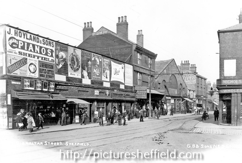
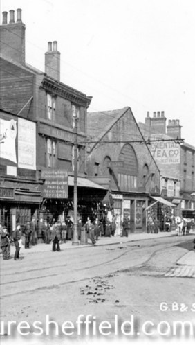
Moorfields. Plan of the ground between Green Lane and Gibraltar. 1824. By John Leather, land surveyor. https://www.picturesheffield.com/frontend.php?keywords=Ref_No_increment;EQUALS;arc04168&pos=105&action=zoom&id=104372 Shows: Green Lane, Dun Street, New Street [Dun Fields or Acorn Street], Ebenezer Square, Ebenezer Chapel, Bowling Green Street, Hunters Lane, Ebenezer Street, Spring Street, Cotton Mill Walk, Lancastrian School Gibraltar, Chapel Street, Moor Fields [Moorfields], school, Allen Street, Holmes Lane. Owners / tenants marked: Abraham Ibbotson, Thomas Cornshaw, James Parkinson, Richard Holmes, John Brown, James Jenkinson, Richard Holmes, and Joshua Fowler. The property where Lancastrian School is shown on 1824 Map is No. 56, John Hinchliff on the 1782 Map. The Earl of Surrey’s tenements in Long Croft, Gibraltar [Street] and Bower Springs 1782. https://www.picturesheffield.com/frontend.php?keywords=Ref_No_increment;EQUALS;arc04123&pos=100&action=zoom&id=103838 The names of a later date have been added by Josiah Fairbank, and the line of Russell Street and Green Lane, and Bowling Green Street, added. Kelham Wheel marked. List of tenants given: John Anderton, - Lenthwaite, Hannah Patten, John Hughes, Joseph Broomhead, William Thompson, Robert Owen, Robert Milnes, John Stacey, Charles Kelk, Widow Jewel / William Jewet, Joshua Jackson, John Tricket, John Henfrey, John Ashwell, John Brownell, George Goodlad, John Ellis, Ruth Brewster, George Dyson, Joseph Dyson, Widow Jackson, Thomas Francis, Joseph Yeadon, Mary Yeadon, John Brownell, William Fowler, Benjamin Wood, Josh. Staniland, Jon. Wilde, Mary Yeadon, Thomas Kippax, Thomas Pinder, Thomas Pindar, Ellis Morton, Godfrey Rowley, William Bradshaw, Robert Dore, Stephen Gibson, Matthew Ingram, William Simpson, Overseers of Sheffield Poor, The Town of Sheffield, Joseph Ashforth, John Ibberson, John Goodall, Charles Stewardson, Charles Townsend, George Wilkinson, Elizabeth Holden, Joseph Swan, Thomas Bell, John Parkin, John Taylor, John Hinchcliff, John Brownell, William - , Jonn. Wa-, John Read, Joseph Bower. Gibraltar Street - draft of the widening scheme, 1837 https://www.picturesheffield.com/frontend.php?keywords=Ref_No_increment;EQUALS;arc04122&pos=84&action=zoom&id=103833 Marked: Bowling Green Street; Lancastrian School; Gibraltar Street; Trinity Street; Copper Street; Cupola Lane; Bower Spring; Furnace Hill; West Bar Green. If this is looking towards Gibraltar Street then the old Lancastrian School could be featured on the left. Drinking Fountain at the junction of Shalesmoor/ Gibraltar Street/ Allen Street and Bowling Green Street, looking towards businesses including Thomas Nixon and son, pawnbroker, Gibraltar Street. s19331 A clearer image, but is it the old Lancastrian School? Gibraltar Street from the junction with Trinity Street (right) showing businesses including No. 220/4 Thomas Nixon and Son, pawnbrokers, Midland Railway Co., parcels receiving office and Nos. 204/6 The Oriental Tea Co., Nichols and Co. s16240
-
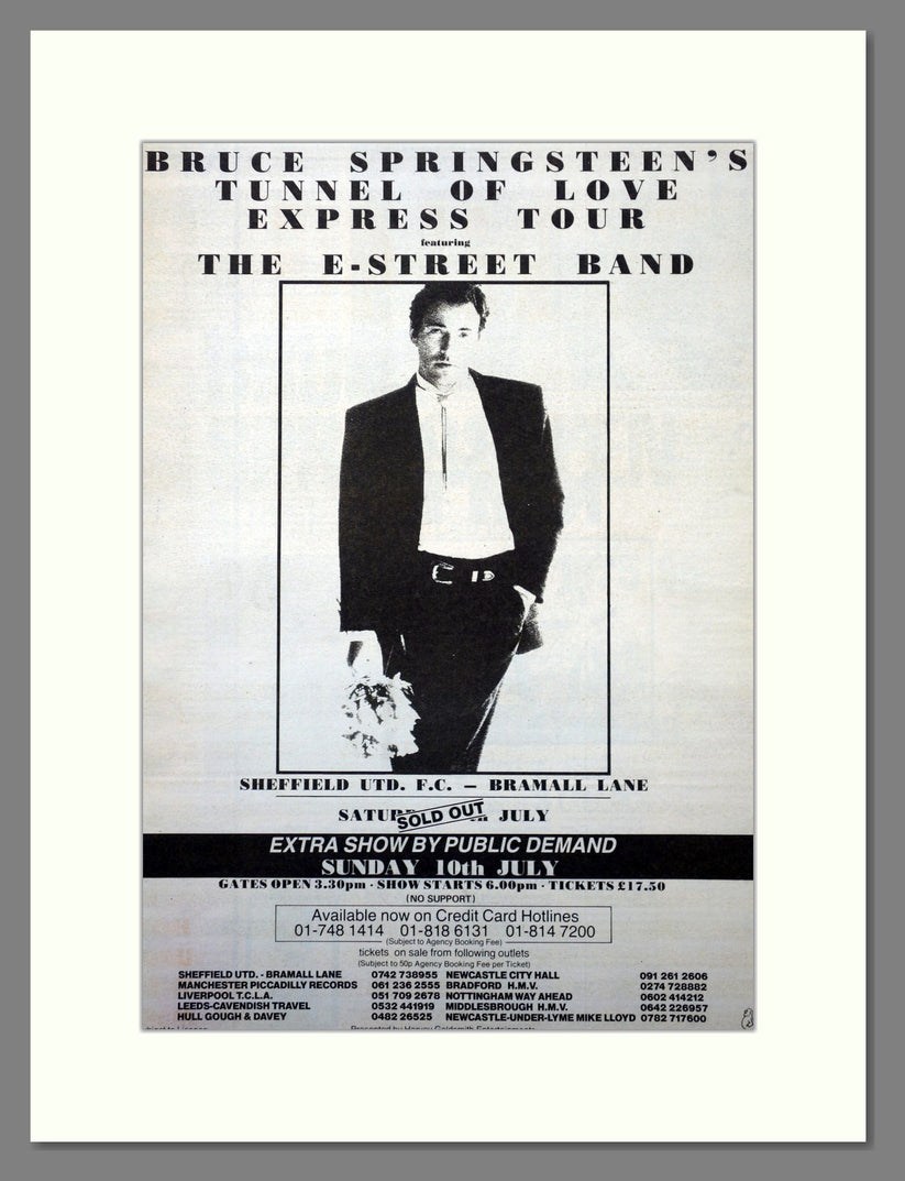
Yes, it was loud!! Living at Brinsworth at the time, we thought the lad who lived over the back was having a loud party outside while his parents were away on holiday. Then realised it was the Springsteen Concert. It was louder than the Def Leppard Concert at Don Valley Stadium some years later, that after the Sound Check the day before was turned down a few notches. Set List: Tunnel of Love Express Tour Bramall Lane 9th July 1988 https://www.setlist.fm/setlist/bruce-springsteen/1988/bramall-lane-sheffield-england-7bd7b294.html
-
Birley Collieries Branch Line
Ponytail replied to Paolo Coopio's topic in Sheffield Buses, Trams and Trains
Derailed wagons at Woodhouse Mill after the crash. 29th February 1908.s03808 About 12-45 on Saturday morning, a Mineral Train was leaving the East Junction, when an Emigrant Special from Liverpool to Grimsby, containing about 300 passengers, travelling at nearly 30 miles an hour, dashed into its rear.The terrible impact caused the immediate death of Goods Guard Rowley. Fireman Clark was pinned beneath the Engine, and it was two hours before he was released: he succumbed to his injuries the following day.Walter Howell, Driver of the first engine, was very badly injured and scalded. Driver Borland and Fireman Jarred both of Liverpool, escaped without injuries, although their engine was almost overturned. For more information about Birley East Colliery see: Winding Up a History of Birley East Colliery, A Rowles Ref: 622.33 SQ. https://www.picturesheffield.com/frontend.php?keywords=Ref_No_increment;EQUALS;s03809&pos=57&action=zoom&id=7398 https://www.picturesheffield.com/frontend.php?keywords=Ref_No_increment;EQUALS;s03810&pos=58&action=zoom&id=7399 Train Crash at Woodhouse Junction. 29th February 1908. Photographer: W. Gothard s03778 Train crash on the Birley Colliery Line. 1919. s03807 Coal Wagon at Birley West Pit. 31st March 1938.s15045 Birley West Pit, unloading coal wagon. 31st March 1938.s02331 PhotographerT.Ws02331. Ward and Co. Birley Colliery Mineral Wagon No. 2494, taken at wagon shop. s15037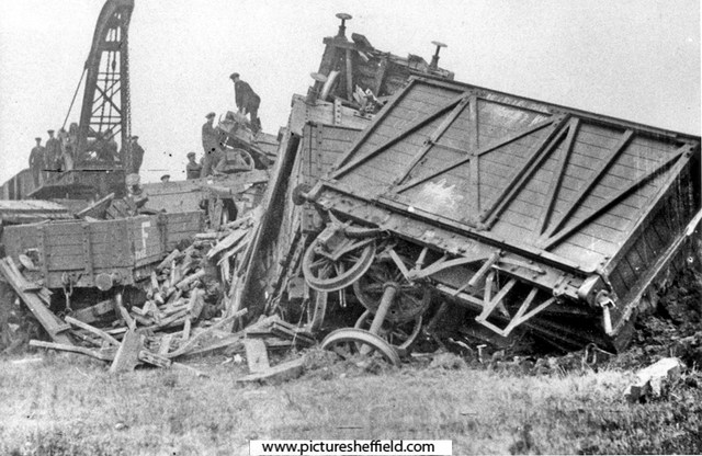

-
The only Smith listed on Stubbin Lane, 1957 and 1965, Mrs. Emma L Smith, at 98 Stubbin Lane.
-
I also left home in 1965 to get married. We had bought a house off Elm Lane at Lane Top . “Aunt Gladys” and her sister ran the Mikado Drink Shop. I put a piece on here a while ago reminiscing about the place…the home made ice lollies and the back room where invited kids were invited to watch TV…….when TVs were a rarity!
-
I left home in 1965 to get married and I expect I remember the greengrocers as Roses on the odd occasion I'd gone shopping with my mum to Firth Park (we lived at Sheffield Lane Top) My sister in law knew Jim Smith and he possibly took over the Bellhouse shop in the mid 1960s? I don't remember a Smiths Greengrocers on Stubbin Lane but do remember the Mikado drink shop where my father took myself and my sister every Saturday afternoon after we had visited Firth Park Library.
-
Curr in his "Coal Viewer and Engine Builder" does mention Watt, briefly on page 20, but the point of his book is to promote his own design of engine which he does in great detail. In 1835 the maximum depth achieved in the North East was 1,590 feet at Monkwearmouth Colliery which was on the deepest part of the coalfield. Other collieries there were also deep - Jarrow, Gosforth and South Hetton around 1.100 feet, though Jarrow brought the coal up in three stages, the maximum lift being 780 feet In 1819 the average depth of Sheffield collieries was 360 feet. There were several shafts at the Hartley colliery and it can be confusing which one is being referred to - for example the "Old Pit" sunk in 1754 was 191 feet ( = 64 yards = 32 fathoms) and the "Mill Pit" sunk in 1830 was 437 feet ( = 144 yards = 72 fathoms)