Search the Community
Showing results for 'coal pit lane'.
-
Hartley Old Pit was started in the 13C, the first records mention it in 1291. It was abandoned in 1844. The Hester pit, aka New Hartley Colliery, (for which I quoted the depth) was then started and reached the low main coal on 29 May 1846. It was a single pit colliery. It was sealed after the disaster of 16 January 1862 and never reopened. In 1874 a new colliery consisting of the Hastings and Melton pits was started nearby which eventually broke into the old workings in 1901. The whole colliery was abandoned in 1959 leaving 70 years of coal below ground. Both Hartley and New Hartley collieries had workings reaching out beneath the North Sea. Thanks for the info on the Sheffield collieries. I've re-read page 20 and can't see a mention of the Watt engine. Page 20 is "Instructions to the Founder" concerning the making of the corf. The description of "The Fire Engine" starts on page 37. Just in case we're looking at different publications, the URL is https://archive.org/details/bim_eighteenth-century_the-coal-viewer-and-eng_1797/page/n19/mode/2up WE both agree that the point of the book is to promote his own designs and inventions, it was the lack of even a passing reference that surprised me, that's all.
-
Curr in his "Coal Viewer and Engine Builder" does mention Watt, briefly on page 20, but the point of his book is to promote his own design of engine which he does in great detail. In 1835 the maximum depth achieved in the North East was 1,590 feet at Monkwearmouth Colliery which was on the deepest part of the coalfield. Other collieries there were also deep - Jarrow, Gosforth and South Hetton around 1.100 feet, though Jarrow brought the coal up in three stages, the maximum lift being 780 feet In 1819 the average depth of Sheffield collieries was 360 feet. There were several shafts at the Hartley colliery and it can be confusing which one is being referred to - for example the "Old Pit" sunk in 1754 was 191 feet ( = 64 yards = 32 fathoms) and the "Mill Pit" sunk in 1830 was 437 feet ( = 144 yards = 72 fathoms)
-
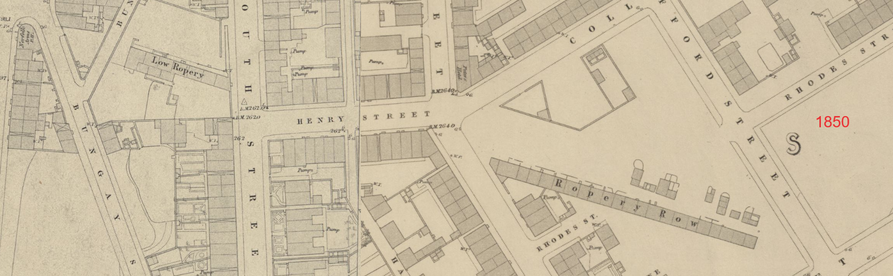
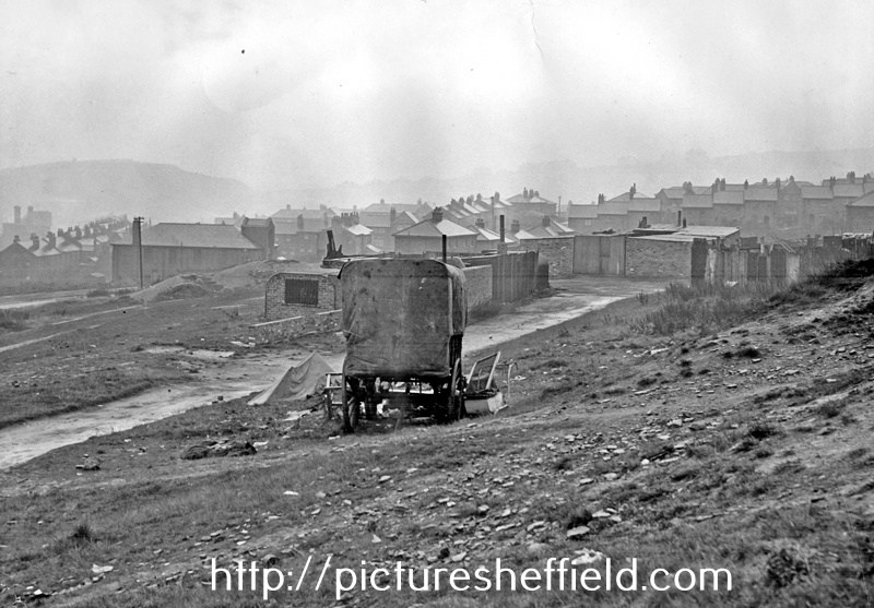
Edmund posted this lease which has Colliers Row marked: A plan of the late John Curr’s leasehold property in Sheffield Park [Duke Street] 1823. https://www.picturesheffield.com/frontend.php?keywords=Ref_No_increment;EQUALS;arc04185&pos=3&action=zoom&id=104944 Marked: Furnace, foundry, gardens, proposed roads, Colliers Row, Clay Wood Road, ropery, Duke Street, [road] to Granville Lane, Robert Calver, Is this the same Colliers Row or was there another at a later period? Colliers Row, Long Henry Street, Park, from junction with The Green, left. January 1940. u00198
-
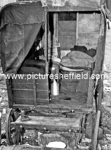
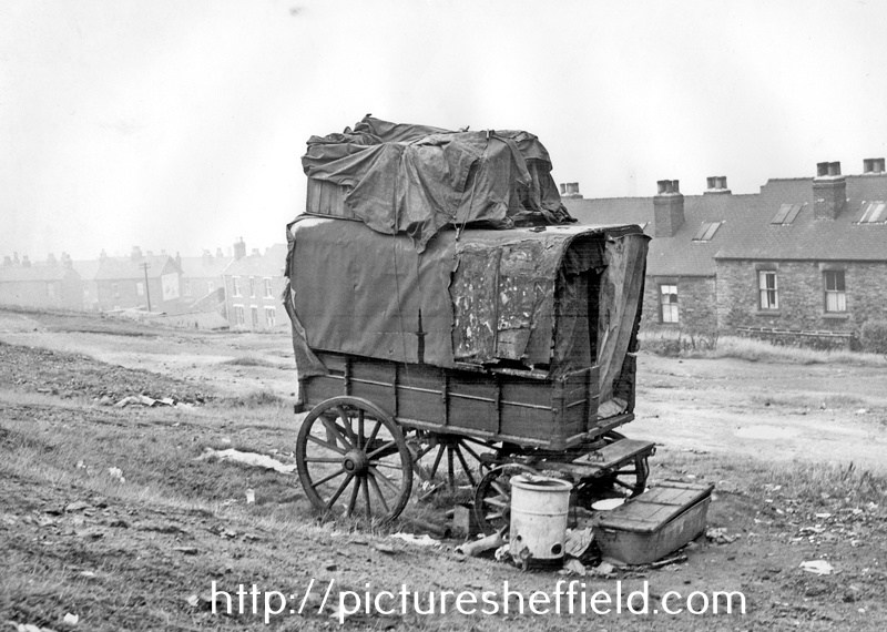
Ex-Railway type van in a deplorable condition, placed on waste land and housing a man and wife and their child aged 1 year and 9 months, and another adult female, both females were pregnant. 31st August 1950. u01685 Photograph shows an ex-railway type van placed on waste land in June 1950. The van measured 8' 9 long, 5' 0 wide and was 5'7 high. The van was in a poor condition and there was no sanitary accommodation or water supply, lighting was by candles and there was a coal fired, metal stove inside the van. The van was generally in a deplorable condition, and the site around was littered with refuse. The occupants were a man and wife and their child aged 1 year and 9 months, and another adult female. Both adult females were expectant and both had other children, either with foster parents or in childrens homes. The occupants were eventually found accommodation by the Social Care Department. u01684 u01686
-
Hi Martin, Watts patent monopoly was extended by Act of Parliament up to 1800, so no doubt there would be a cost implication. Newcomen's engine continued to be installed at collieries in large numbers during the period of Watt's patent. The Newcomen engine was much simpler and cheaper than Watts' engine, and Watt's advantage of economy of fuel was irrelevant when operating at a coal mine, as opposed to say tin mines (Watts machinery did well in Cornwall). I think that long ropes tended to be produced for nautical applications (as your Chatham example). Even where deep pits operated (such as in the North East), their lifts were in sections, and most other colliery depths were much less than the average UK sea depths. An anchor rope for a ship would have unknown and variable depths to contend with, whereas the requirement in a colliery was known and fixed.
-
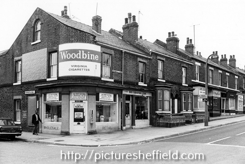
Nos. 322 JKS Pest Control (former corner shop); 320, Ray's Furniture Store; 318-316; 314, Carl Gough, dental technician; 312, H. Skelton, jeweller; 310, Hair Magic, ladies hairdressers and 308, Bramall Lane from the junction with Harrington Road. August 1974.s24897
-
Interesting that Curr's The Coal Viewer, and Engine Builder's Practical Companion is of 1797. It describes in detail a Newcomen engine, but no mention of the Watt engine which had come onto the market in 1776 - quite a revolutionary year.
-
Eyre Street, Lots of Thomas Fisher and Edwin Unwin, in George Curr’s land late Dr Frith's, [1827] https://www.picturesheffield.com/frontend.php?keywords=Ref_No_increment;EQUALS;arc04101&pos=5&action=zoom&id=103589 Shows Jessop Street, Jessop Lane, Eyre Street Earl Street and Eyre Lane. Owners / Tenants marked: Thomas Fisher, Edwin Unwin, William and John Alsop / Joseph Foote. According to the article in the Star, dated 19th January 2023. "John’s brother, George (1749-1826)" Is this "George" or another relative?
-
The Coal Viewer and Engine Builder's Practical Companion, by John Curr of Sheffield. Quite a difference in Price! https://www.amazon.co.uk/Viewer-Builders-Practical-Companion-Sheffield/dp/1379973619 https://www.forumauctions.co.uk/61/Curr-John-The-Coal-Viewer-and-Engine-Builder-39s-Practical-Companion-only-edition-Shef/1?view=lot_detail&auction_no=1002 https://www.michaelkemp.co.uk/products/author/JOHN CURR, of Sheffield Or download: https://archive.org/details/bim_eighteenth-century_the-coal-viewer-and-eng_1797
-
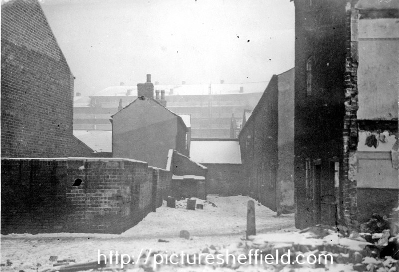
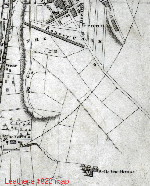
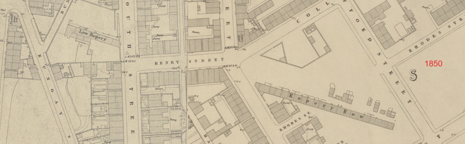
John Curr obtained a patent for flat rope in November 1798. John Currs 1798 flat rope patent The rope was made by stitching together several round ropes. The advantage was that for winding up coal from a pit the flat rope effectively increased the diameter of the pulley as the load neared the top, allowing the speed to increase, the weight of rope decreasing as it wrapped around the pulley. Initially he bought in round rope from others, to stitch together using machinery which was situated on the site that would later be the lake in the grounds of "The Farm" and was within yards of his new 1803 house, Belle-Vue. By 1803 he had made arrangements for a warehouse in Tipton to service the West Midland Coal industry with his products. In April 1803 the cost of the ropes was a shilling per pound, with a month's credit, and the coal masters to pay for the carriage by barge. The ropes were warranted to last as long as six to eight round ropes of equal weight. Almost immediately though, users found problems with durability due to the quality of the round rope incorporated in Curr's product. Curr investigated and obtained two further patents: in March 1806 for spinning hemp to make yarn, and in August 1806 for twisting that yarn to make round rope. He then commenced making his own round rope in various sizes up to 7 inches in circumference. In 1807 Curr's patent round ropes were also being made in the ropery of W.Bourne and Son at Hull, for shipping use. Curr's round rope was a good product in itself and contributed to the quality of his flat ropes. Description of Currs Rope patents By 1813 rope production was so successful that it warranted a dedicated ropery building. The works he put up in 1813 (see Fairbanks' plan), was between his house, Belle-Vue, and the town, the land being an addition to the land already on lease from the Duke. Plan of Currs Leases from the Duke There were four storeys to the works, the three lower ones were occupied as cottages or perhaps warehousing, and the rope making was carried out on the fourth, which was continuous for the length of the building. The ropery crossed the already existing South Street, so an arch was required to allow traffic along the street. Derbyshire Archaeological Society Bulletin No 15 (Spring 2000) refers to two Josiah Fairbanks field books in Sheffield Archives (ref SAFC FB 137 & 138 ) which supposedly show a railway between Curr's (flat) "Rope place" on the site of The Farm's lake, and the later (round) Ropery. By 1820 Curr had sold the rope patent rights and manufacturing machinery to Richard and William Furley of Gainsborough, who also maintained a warehouse in Tipton. When no longer required to operate as a ropery, probably in the 1840s, the building was reduced in height and partitioned, to facilitate its use as 2 room cottages. Possibly some of the lower storeys had previously been used as warehousing for raw materials and finished goods. The length of Ropery Row was originally about 270 yards and it was still the full length in 1823. By 1831 the row had been broken up with a section in the centre removed, so it was down to about 180 yards. The 1850 map shows it as comprising 2 sections - "Low Ropery" which was probably where the meeting rooms were, west of South street, and the eastern section comprising 22 dwellings, 100 yards long. Large rooms remained in existence above the Low Ropery section. In the 1850s there was a school there. The United Methodist Church (Shrewsbury Road) were based in the Row in the late 1850s, and in 1872 there was a Temperance Hall. Political meetings of 500 electors were held there in 1886 and 1892. In 1876 Sale Memorial Church (St Lukes) was erected on this site of the western end of the Ropery, part of which had been purchased and demolished for the purpose. In 1841 the census showed almost half the one-up-one-down cottages in the Row unoccupied and in that year Mr. Mudford was operating a ropery in a large room above three of the cottages. From the 1851 to the 1911 census the cottages were numbered 1 to 21 and fully occupied. The Row was demolished in 1912, at which time there was a chip shop at one end, seen in the PictureSheffield photo (incorrectly dated as 1925 - it appears in a 1912 newspaper article about the demolition). Ropery Row before demolition 1912
-
Plan of Whiteley Woods (Part 1) -section from Dead Lane to Forge Houses. 1897. https://www.picturesheffield.com/frontend.php?keywords=Ref_No_increment;EQUALS;y09356&pos=15&action=zoom&id=63677 Plan of Whiteley Woods (Part 2) -Whiteley Woods (Part 2) - section from Oakbrook Road to Dead Lane. 1897 https://www.picturesheffield.com/frontend.php?keywords=Ref_No_increment;EQUALS;y09358&pos=16&action=zoom&id=63679 Plan of estates at Rand Moor [Ranmoor] and Nether Green in the township of Upper Hallam the property of John Eyre. 1830. https://www.picturesheffield.com/frontend.php?keywords=Ref_No_increment;EQUALS;arc03994&pos=59&action=zoom&id=102815 1. Farm House with barns, stables, yards and gardens, 2 Small Croft, 3 Stackyard Field, 4 Upper Bank, 5 Broad Field, 6 Broad Field Bottom and Lower Bank, 7 Ibbotson Wood, 8 Four Days Work, 9 Broom Field, 10 part in the road, 11 Upper Lords Field, 13 Porter Wheel and ground open to it, 14 Woody Bank, 15 Dam, 16 Low Porter Field, 17 Middle Porter Field, 18 Middle Porter Field Bottom, 19 Near Porter Field Bottom, 20 Near Porter Field, 21 Rough Field and Fox Croft, 22 three dwelling houses with an outhouse yard and gardens, 23 garden, 24 farm house, yard, dwelling houses and garden, 25 House Field, 26 Woody Bank in [?House Field]. Names include Elizabeth Hawkesworth, John Beale, William Andrews, Susannah Ibbotson, George Stringer, Thomas Binney, Jos. Biggin, Hannah Elliott, George Parker, Edmund Wilson, Ebenezer Marsden, Geo. Worrall, William Fox, Mary Trippet, William Wilson. Shows Water Lane, Porter Bridge, road from Bents Green, Road from Whiteley Wood, Dam, Porter Wheel, Porter Brook, Ibbotsons Wheel, Ibbotson Wood, Spurgear Wheel Dam, Road to Lydgate, Road to Sheffield.
-
Upper Forge (Forge Dam), Porter Brook at Ivy Cottage Lane, c. 1826 https://www.picturesheffield.com/frontend.php?keywords=Ref_No_increment;EQUALS;arc06218&pos=56&action=zoom&id=102553 Detail from Plan of the Whiteley Wood Works and other property belonging to Samuel Mitchell and Co., [1826] (arc03974). Plan of the Whiteley Wood Works and other property belonging to Samuel Mitchell and Co., [1826] https://www.picturesheffield.com/frontend.php?keywords=Ref_No_increment;EQUALS;arc03974&pos=55&action=zoom&id=102552 From left to right: Dam, Upper Forge, Old Dam, road from Brookhouse Green, wood, plantation, meadow, plantation, dam, Whiteley Wood works, forge, plantation, Bottoms Wood, The Heys, part of Dodge Field, part of Little Field, Woody, Croft, Holme Bank, dam, wheel, Porter Field, road to Sheffield and road to Nether Green. Key: In Upper Hallam - Forge Dam Banks and land adjoining, plantation, lower part of Dodge Field, Upper Holme Bank, Lower Holme Bank, road through Holme Bank, road along Porter field, Porter field, grinding wheel, dam goight banks, etc. In Ecclesall Bierlow - House Woody Bottom Lane and wood, plantation and goight, meadow, road along top of plantation, road through meadow, plantation and rad through, dams with the banks, Whiteley Wood Works Houses, Bottoms Wood, the Heys the part pasturable, road and remaining part, road from the Heys to Whitley Wood Chapel, plantation and chapel, part of Little Field, Woody Bank, Croft, road to the grinding wheel and Woody part adjoining the River. Whiteley Wood Works and Wire Mill Dam, Porter Brook, Whiteley Wood Road (formerly the works of Thomas Boulsover), c. 1826. https://www.picturesheffield.com/frontend.php?keywords=Ref_No_increment;EQUALS;arc06219&pos=57&action=zoom&id=102554 Detail from Plan of the Whiteley Wood Works and other property belonging to Samuel Mitchell and Co., [1826] (arc03974).
-
Plan of an estate in the Township of Upper Hallam, the property of William Silcock. 1825. https://www.picturesheffield.com/frontend.php?keywords=Ref_No_increment;EQUALS;arc03975&pos=58&action=zoom&id=102573 Surveyed by W. and J. Fairbank. Scale 0.5 inch : 1 chain. Shows road from Fulwood [possibly Old Fulwood Road / Fulwood Road], public house [possibly Blacksmiths Arms], road to Sheffield John Hodgson rsquo;s land, Hannah Heywood, Porter Brook, Samuel Mitchell and Co., Heald Wood, road to Whiteley Wood, road from Greystones [Highcliffe Road / Hangingwater Road]; Upper Plantation, Lower Plantation, Little Croft, Pingle, Whinney Bank, Wheat Field, Long Lands, Lower Field, Upper Field, Lily Croft, Lane Close, Dodge Field, Far Head, Near Heald, Upper Porter Field, Middle Porter field, Far Porter field, Near Porter Field.
-
Plan of estates at Rand Moor [Ranmoor] and Nether Green in the township of Upper Hallam the property of John Eyre. 1830. https://www.picturesheffield.com/frontend.php?keywords=Ref_No_increment;EQUALS;arc03994&pos=59&action=zoom&id=102815 1 Farm House with barns, stables, yards and gardens, 2 Small Croft, 3 Stackyard Field, 4 Upper Bank, 5 Broad Field, 6 Broad Field Bottom and Lower Bank, 7 Ibbotson Wood, 8 Four Days Work, 9 Broom Field, 10 part in the road, 11 Upper Lords Field, 13 Porter Wheel and ground open to it, 14 Woody Bank, 15 Dam, 16 Low Porter Field, 17 Middle Porter Field, 18 Middle Porter Field Bottom, 19 Near Porter Field Bottom, 20 Near Porter Field, 21 Rough Field and Fox Croft, 22 three dwelling houses with an outhouse yard and gardens, 23 garden, 24 farm house, yard, dwelling houses and garden, 25 House Field, 26 Woody Bank in [?House Field]. Names include Elizabeth Hawkesworth, John Beale, William Andrews, Susannah Ibbotson, George Stringer, Thomas Binney, Jos. Biggin, Hannah Elliott, George Parker, Edmund Wilson, Ebenezer Marsden, Geo. Worrall, William Fox, Mary Trippet, William Wilson. Shows Water Lane, Porter Bridge, road from Bents Green, road from Whiteley Wood, dam, Porter Wheel, Porter Brook, Ibbotsons Wheel, Ibbotson Wood, Spurgear Wheel Dam, road to Lydgate, road to Sheffield.
-
The Ringinglow estate, the property of the late Thomas Rawson, 1827] https://www.picturesheffield.com/frontend.php?keywords=Ref_No_increment;EQUALS;arc03946&pos=44&action=zoom&id=101954 Git Mottram: 1. Rough Smeltings and Croft, 2. House and garden, 3. Upper Smeltings, 4. Lower Smeltings. In hand, 5. New planting, 6. Bank plantation, 7 and 8. plantations, 9. Weigh house, 10. Rough plantation toll house and part cultivated, 11. Stack Garth Plantation, 12 - 14. Plantations, 15. Upper Lumb, 16. Lower Lumb, 17. Plantation adjoining Porter Brook. 18. plantation in Angram Lane. Richard Whitworth 19. Ringinglow Inn [later the Norfolk Arms], homestead, out buildings, yard and garden, 20. Stack Garth, 21. House Field, 22. Upper Planting field, 23. Cow Pasture, 24. Lamb Field, 25. Low Rye Field, 26. Rye Field. 27. Horse Pasture, 28. The Rough Banks; James Creswick, 29. Bottoms, 30. Well Bank, 31. Well Field, 32. Middle Common Piece, 33. Four Acre, 34. Barley Field, 35. Wiggin Field, 36. Bennet Field and Calf Croft, 37. Anise Field, 38. Planting Field, 39. Croft, 40. Homestead, house etc., 41. Old Field; Benjamin Fox, 42. Bank., 43. [black], 44. Broomhead Field, 45. Pingle. Thomas Watson, 46. Allotment. Also shows colliery, road from Grindleford Bridge [Sheephill Lane], Ringinglow Road, Barber Fields, road to Fulwood [Fulwood Lane], site of [Norfolk Arms], [toll house], house field, Angram Lane, road to Birks Green and road from Bower Hill [Cottage Lane?].
-
A plan of the Farm lately held of the Duke of Norfolk by Geo. Calton, with the Whitelead Works, etc. erected thereon. Date Period, 1800-1850 https://www.picturesheffield.com/frontend.php?keywords=Ref_No_increment;EQUALS;arc03404&pos=28&action=zoom&id=98647 Fields between the Porter and the Coach-and-Six Farm and between the White Lead Works and the Corn Mill dam; Lead works and Cutler's Wheel clearly marked; numerical list with field names and descriptions and acreages; Proposed new course of the River Porter added, with new acreages listed. Dated from rentals. Coloured, on parchment. (Shoreham Street, Arundel Street, Brown Street, Furnival Street, White Lead Works, Leadmill Road, Leadmill Street, Matilda Lane, Matilda Street, Pond Street (south end), St Mary's Road) White Lead Works and the fields between the Porter and the Sheaf, on either side of (modern Leadmill Road)
-
Arundel Street. Section. Levels taken for a common sewer from Porter Street to the River Porter near the White Lead Works, [1825] https://www.picturesheffield.com/frontend.php?keywords=Ref_No_increment;EQUALS;arc04027&pos=63&action=zoom&id=103213 Refers to Arundel Street, end of Duke Street, end of Earl Street, end of Eyre Lane, Porter Lane, and a culvert.
-
Land of John Watson and T. B. Holy, Arundel Street, [1830] https://www.picturesheffield.com/frontend.php?keywords=Ref_No_increment;EQUALS;arc04032&pos=67&action=zoom&id=103277 Shows Bye Goight, River Porter, land sold by James Fernley to Ellin and Ingall; Pearson and Griffith; Josh. Houldsworth; Houldsworth Lane; and Thomas Booker. Lands of T. Holy on the south side of Sheffield, showing land schemed for gardens and roads, c. 1804 and 1818 https://www.picturesheffield.com/frontend.php?keywords=Ref_No_increment;EQUALS;arc04030&pos=65&action=zoom&id=103260 Shows Arundel Street, Furnival Street, Eyre Street, Charles Street, Browne Street [Brown Street], [Arundel Lane]. Refers to Daniel Darwent, Benjamin Hadfield, Robert Hide, Benjamin Raworth [Rayworth], Joseph Skinner, Thomas Potter, David Davey, Thomas Smith, Henry Froggatt, Joseph Cantrill, Josh. Skinner, William Butcher, William Morley, Firth and Co., Charles Hutchinson, Robert Colyer, Josh. Clarke, James Linley, Jonathan Helliwell, Robert Hide, Peter Frith, and William Colwell.
-
London Road. Completed layout of the streets in Rowland Hodgson's land, [c. 1818] arc04154 See also arc04153. https://www.picturesheffield.com/frontend.php?keywords=Ref_No_increment;EQUALS;arc04154&pos=69&action=zoom&id=104100 Marked: William Stratford, William Cooper, Samuel Johnson, James Richardson, Samuel Mather, William Staley, Henry Lester, John Reaney, Thomas Burton, Henry Hewitt, John Cadman, Thomas Hounsfield, George Carnall, William Flockton, Catherine Younger, William Staley, Robert Marples, Jackson Frow, Michael Butler, David Craven, William Bunting, John and William Bridgens, Thomas Booker, T. Worstenholme, James Bowen or Bower, Robert Green, William Steadman, John Webster, William Cooper, William Beardstall?, Roger Brown and Sons, Jos. Garlick, George Turton, John Richardson, William Ashall, James Merryweather, George Hall, Jno. Gallimore, Joseph Bower, John Jackson, Joseph Hutchinson, Machin and Hall, Jos. Priest, William Hallewell, Young Sick Society, George Wild, Samuel Rogers, John Wright, William Roper, John Shead, Charles Gallimore, John Mayman, John Hewitt, Robert Walker, Joseph Twells, Joseph Bower, and Jno. Sheldon. Land measured for Rowland Hodgson, with new streets laid out - Hermitage Street, George Street (now Boston Street) and George Lane, [1817] arc04153. See also arc04154. https://www.picturesheffield.com/frontend.php?keywords=Ref_No_increment;EQUALS;arc04153&pos=68&action=zoom&id=104099 Marked: 1 Samuel Newbould, 2 Samuel Johnson, 3 and 4 Thomas Jacklin, 5 Jonathan Crookes, 6 Jonathan Sherwood, 7 William Needham, 8 Thomas Worstenholm, 9 William Brown and George Carnall; also shows William Smith and Rowland Hodgson's gardens; and River Porter.
-
A map of the Dams, Goights and other Works belonging to the Pond Forge Co. together with some other intermediate properties. 1820. https://www.picturesheffield.com/frontend.php?keywords=Ref_No_increment;EQUALS;arc04213&pos=73&action=zoom&id=105197 Boardman's Bridge, wear [weir], Porter Brook, goight, River Sheaf, Upper Dam, Sheaf Lane, bridge, Upper Forge Wheel, dam, Upper Forge, Sheaf Mill, steam engine, Lower Forge, grinding wheel, arched goight, tail goight, Shude Hill, Hospital Bridge, Hospitals, Sheaf Bridge, Castle Orchards Wear [weir], River Dun [River Don], Pond Street, Forge Lane, Pond Well Hill. Late Joseph Ward, John Hounsfield, Josiah Blackwell, late Abraham Wright, S. Woodcock and Sons, Joseph Blackburn, Thomas Mearbeck and Co., S. Rawson and Co. [?Thomas Rawson and Co], Joseph Shimmeld, John Vickers, Sheffield Gas Light Co., S. and S. Darwin, Sarah Beeley, Widow Beardsall, John Hale, Widow Badger, and J. B. Ward.
-
Ecclesall Inclosure (enclosure) M No. I - Crookesmoor, Little Sheffield, Little Sheffield Moor. 1788. https://www.picturesheffield.com/frontend.php?keywords=Ref_No_increment;EQUALS;y10001&pos=78&action=zoom&id=65488 Shows: Tapton Hill Road; Smith Wood Road; Fulwood Road ; Clarkehouse Road; Turnpike Roads; Young Street; Bishop Street; Tudor Street; Hereford Street; Bright Street; Cumberland Street; Porter Lane; Jessop Street; Earl Street; Rockingham Street; Button Labe; Carver Street; Duke Street; Norfolk Street. Also Porter Brook; Bennett Wheel (Little Sheffield Moor Wheel) and list of Names.
-
Plan of proposed extension of Eyre Street to Porter Street and also the proposed widening of Porter Bridge. 1845. https://www.picturesheffield.com/frontend.php?keywords=Ref_No_increment;EQUALS;arc06810&pos=76&action=zoom&id=106241 Also shown are Brammall Lane [Bramall Lane], Hereford Street, Sylvester Street, Cumberland Street, and the Porter Brook.
-
A map of Cinderhill Wheel Old Dam and the additions intended to be made to it. 1752. https://www.picturesheffield.com/frontend.php?keywords=Ref_No_increment;EQUALS;arc03406&pos=91&action=zoom&id=98649 The old and new dams clearly shown, with a perspective drawing of the mill house. Measurements given on the map and there is an explanation of additions with acreages. Content of the new dam also given; house and border coloured. Pond Corn Mill (on the Porter) and some of the Stand Ley Closes (also known as the Cinder Hill Wheel, this Mill was west of modern Leadmill Road near Shoreham Street; the Stand Ley Closes lay to the south and west of the mill and dam). Brittain Street, St Mary's Road, Shoreham Street, Pond Corn Mill, Mary Street, Pond Street (south end). A map of the Stand Leys and some other contiguous Lands with the Dam and Mill (formerly called Cinder Hill Wheel) 1764. https://www.picturesheffield.com/frontend.php?keywords=Ref_No_increment;EQUALS;arc03415&pos=93&action=zoom&id=98651 arc03415 The Wheel and Dam clearly shown; shuttle marked; colours distinguish tenancies; numerical list with tenants, field names and descriptions and acreages; on parchment. Pond Corn Mill (on the Porter) and some of the Stand Ley Closes (also known as the Cinder Hill Wheel, this Mill was west of modern Leadmill Road near Shoreham Street; the Stand Ley Closes lay to the south and west of the mill and dam). Clough House Lane, with the site of Clough House shown. Lenton Street, Duchess Road, Pond Corn Mill, Mary Street, Margaret Street, Matilda Street, Pond Street (south end), St. Mary's Road.
-
A plan of two Closes held under the Duke of Norfolk by Benjamin Roebuck, with Silvester Wheel [Sylvester Wheel] and the adjoining Damms (sic) and Gardens in John Wilson's possession, [c. 1760-1770] https://www.picturesheffield.com/frontend.php?keywords=Ref_No_increment;EQUALS;arc03285&pos=87&action=zoom&id=98446 Upper and Lower Dams, Wheel and Weirs clearly shown; includes two closes to the north of the dams; numerical list with tenants, descriptions and acreages; coloured, on parchment. Sylvester Wheel and the closes to the south (these closes adjoin those in the section above; the wheel was on the Porter Brook near modern Sylvester Street). (Alsop Lane, Earl Lane, Earl Street, Eyre Street, Jessop Lane, Jessop Street, Sylvester Street) Silvester Wheel with the Dams and Appurtenances held of the Earl of Surrey by John Wilson. 1784. https://www.picturesheffield.com/frontend.php?keywords=Ref_No_increment;EQUALS;arc03286&pos=88&action=zoom&id=98447 Wheel, Dams and Gardens clearly shown; measurements of gardens Sylvester Wheel and the closes to the south (these closes adjoin those in the section above; the wheel was on the Porter Brook near modern Sylvester Street). A plan of the Stand Ley Closes, etc. 1790. https://www.picturesheffield.com/frontend.php?keywords=Ref_No_increment;EQUALS;arc03414&pos=92&action=zoom&id=98650 The closes adjoining those shown in arc03415 with an outline of the Sylvester Wheel and Dams; Tenants and acreages given. (St. Mary's Road, Charlotte Road, Clough Road, Clough House Lane, Hereford Street, Sylvester Street, Mary Street, Midland Lane, Margaret Street, Shoreham Street) [Sylvester Wheel and the closes to the south (these closes adjoin those in the section above; the wheel was on the Porter Brook near modern Sylvester Street] Plan of the Duke of Norfolk's land in Alsop Fields and at Sylvester Wheel divided into lots for sale. 1804. https://www.picturesheffield.com/frontend.php?keywords=Ref_No_increment;EQUALS;arc04029&pos=64&action=zoom&id=103259 The plan shows the plots bought and the later building schemes. Shows Hereford Street, Cumberland Street, Jessop Street, Silvester Street [Sylvester Street], Arundel Street, Furnival Street, Porter Lane, Eyre Street, Duke Street, [Porter Brook], new cut, lsquo;old course of the river rsquo;, bridge, wear [weir]. Refers to Thomas Holy, George Rhodes, Joshua Holdsworth, John Watson, James Bean, Isaac Smith, Robert Mills, William Tyson, Ann Fox, Joseph Waterhouse, Michael Riley, Sarah [Broomhouse?], Edward Maden / Madin, Samuel Kirkby, John Gillott, Malin Gillot, William Howson, Dr. Firth, [?R. Cindell], E. W. Drury, John Hornden, M.D., Thomas Warburton, Joseph Herrings, George Prior, William Littlewood, Joseph Smith. Plan of certain freehold land near Sylvester Wheel, the property of Thomas Holy. 1831. https://www.picturesheffield.com/frontend.php?keywords=Ref_No_increment;EQUALS;arc04273&pos=75&action=zoom&id=105747 Marked: Sylvester Street, Sylvester Wheel, River Porter, upper dam, lower dam, land sold to Earl Fitzwilliam, Ellin Lane, tail goight, Arundel Street, Arundel Lane, Jessop Street, Eyre Lane, and Earl Street.
-
Bennett Wheel. A plan of the Cutler's Wheel House on Little Sheffield Moor held of the Earl of Surrey by James Bennett. 1784. https://www.picturesheffield.com/frontend.php?keywords=Ref_No_increment;EQUALS;arc03503&pos=82&action=zoom&id=91098 Bennett's Wheel and Dam, the watering place and all the courses of the River Porter shown; some measurements. Watering Place. (Ellin Street, St Mary's Road). Weighing machine house and some ground adjoining Bennet’s Dam belonging to George Bennet, [1807] https://www.picturesheffield.com/frontend.php?keywords=Ref_No_increment;EQUALS;arc03640&pos=33&action=zoom&id=99191 Bennett's Wheel and the land adjoining as divided into lots for sale, The Moor, [1819] https://www.picturesheffield.com/frontend.php?keywords=Ref_No_increment;EQUALS;arc04155&pos=70&action=zoom&id=104118 The plan includes a building scheme over the part of the dam adjoining South Street, but it was not proceeded with. Shows South Street, Hereford Street and Porter Lane. Also, [River Porter] and Bennett's Wheel. Bennett's Wheel and premises adjoining agreed to be sold to Thomas Ellin. 1831. https://www.picturesheffield.com/frontend.php?keywords=Ref_No_increment;EQUALS;arc04156&pos=71&action=zoom&id=104119 Marked: South Street, Hereford Street, Porter Street, Sylvester Street, bridge, River porter, wear [weir], goight, tail goight, Bennets [Bennett's ] Wheel, dam, Back Lane, bye wash, and garden. Tenants / owners: Samuel Newbould, John Watsen [Watson], Peter Jerrison, and late George Hodgson. Note: the Field Book has Sylvester Wheel, but this is palpably an error.