Search the Community
Showing results for 'coal pit lane'.
-
The old Shirecliffe Hall? Shirecliff Hall farm with some contiguous lands in Brightside Bierlow. 1762. Surveyed for the Duke of Norfolk. https://www.picturesheffield.com/frontend.php?keywords=Ref_No_increment;EQUALS;arc04005&pos=1379&action=zoom&id=103139 1 Shire Acre Hill, 2 Oaken Bank or Hand Bank, 3 Coach Way, 4 Cook Wood, 5 Nether Long Lanes, 6 Lane, 7 Upper Long Lands, 8 Far Robinsons Field, 9 Near Robinson Field, 10 two Cottages, Orchard and Garden, 11 Kitchen Greave, 12 Little Kitchen Greave, 13 Great Pond Meadow, 14 Little Pond Meadow, 15 Upper Pond Meadow, 16 Great Pear Tree Field, 17 Paddock, 18 Shirecliffe Hall, Outhouses, Yard, Orchards, Garden, Ponds, etc., 19 Little Pear Tree Field, 20 Waste hill with lane on both sides, the woods, 21 Crossley Buskes, 22 Long Crossleys, 23 Middle Crossleys, 24 Little Crossleys, 25 Great Crossleys, 26 Crossley Lane, 27 Yew Tree Field, 28 Little Patterson Flat, 29 Great Pattern Flat, 30 Slate Delf Field, 31 Nearer Little [Stubbd?] Piece, 32 Green Field, 34 - 40 Tofts, 41 A Little Lane, 42 Little Roe Wood, 43 Great Roe Wood, 44 Seven Acres, 45 Four Acres, 46 - 47 Five Acres, 48 - 49 Two Acres, 50 Little Cockshutt, 51 Great Cockshutt, 52 Great Subbd Piece, 53 Little Stubbd Piece, 54 A Little Paddock adjoining, 55 - 56 Tofts, 57 Shaw Gate, 58 Breirley Field, 59 Little Busk Meadow, 60 Lamb Field, 61 Busk Meadow, 62 New [?Boar] Leys, 63 Far [?Boar] Leys. Also shows 'The Old Park'.
-
Plan of Garden Street as first laid out, c. 1783. https://www.picturesheffield.com/frontend.php?keywords=Ref_No_increment;EQUALS;arc04113&pos=1387&action=zoom&id=103725 Refers to land purchased by William Fairbank of Francis Fenton for £80 raised by subscription in Sheffield Meeting and given to the Earl of Surrey in exchange for the addition to the burying ground in the year 1782; also Old Burying Ground of the People called Quakers, a school [St Luke's parochial school], an Independent Chapel [Congregational?], also, property assigned to the Young Society; top right is Hollis Hospital Lane. Names marked: Joseph Henson, Richard Owen, John Holbem, Widow Vaughan, John Green, Jos Mekin, Luke Ezra, Ridgard, Harman, Michael Pryor, Joseph Roberts, Jonathan Wilde, James Vickers, Timothy Twybill, William Stocks, John Wingfield, Benjamin Jepson, John Harrison, John Bristow, John Kenyon, Thomas Betts, Joseph Binney, John Hunter, John Sheppard, Charles Brookfield, Henry Holbert, Widow Anne Twybill, Samuel Hill, George Woodhead, John Kirk, Thomas Cawton, John Carr, George Carr, Jonathan Drabble, John Beardshall, John Netson, Matthew Siddall / Siddal, Thomas Smith, Humphrey Butcher, John Harrison, Joseph Drabble, Joseph Haywood, John Binney, Thomas Jackson, James Travis, William Brightmore, Joseph Peace, John Leathley, John Auckland, and Mary Newport. In reference to the article in the previous post. "Old site new Connections." mentions a plan of Garden Street 1781. Plan of Hollis Croft 1787-9 posted previously. "Fairbank and Son undertook mapping of the area in the late 18th century. A plan was produced of Hollis Croft between 1787 and 1789 and an adjacent plan of Garden Street was completed earlier in 1781. The two plans taken together provide coverage of the entire site. A series of courts with houses are depicted, incorporating probable small-scale industrial and/or commercial enterprises on the northern frontage of Hollis Croft. A similar pattern is shown on the south side of Hollis croft, but here some of the industrial enterprises appear to be on a larger scale with a large plot consisting of buildings around a central courtyard owned by John Kenyon (the site of a saw and steel works; see below). The premises directly to the west of this fronting Garden Street were a tool and steel works owned by John Harrison (Wessex Archaeology 2018a)."
-
A Plan of the Castle Orchards: The property of the Duke of Norfolk. 1767. The land from the Hospital Garden to the Walk Mill Weir, including the old Simon Wheel and Dam; numerical list with tenants, field names and descriptions and acreages. Park Furnace and the Simon Wheel (the works on the south side of the River Don from the junction with the Sheaf to modern Leveson Street) Furnival Road/Victoria Station Road. https://www.picturesheffield.com/frontend.php?keywords=Ref_No_increment;EQUALS;arc03393&pos=12&action=zoom&id=98632 A Map of the lands and works in the north park of Sheffield Park. 1788. Castle Orchards, Simon Wheel, Walk Mill Wheel, Royds Mill. https://www.picturesheffield.com/frontend.php?keywords=Ref_No_increment;EQUALS;y09966&pos=11&action=zoom&id=65481 A Map of Hall Car Farm, Royds Mill Farm and sundry other contiguous lands of the Earl of Surrey, with alterations [Savile Street], 1779, 1781. https://www.picturesheffield.com/frontend.php?keywords=Ref_No_increment;EQUALS;arc04240&pos=18&action=zoom&id=105356 Tenants listed: John Walker - close, etc; James Andrews - Hill Side Garden; Thomas Wilkinson - garden, etc; Josh. Ibberson - Walk Mill Meadow, grinding wheel, etc; heirs of John Hawksley; John Dixon (crossed out); Thomas Handley - Hill Side, Spital Field, orchard, stack yard, messuage, Coney Greave, Shoulder of Mutton Close, hop yard, Little - Hill, Pighill, Great Meadow, Long Meadow, Hanging Banks, Near Hield Field, Little Hollow Coney Greave, Larger Hollow, Near Butler Field, Middle Butler Field, Little Butler Field, Upper Wood Side, Upper High Field, Nether Wood Side, Wood Bottom, Little Wood Bottom, Little Old Park, Rough Field, Old Park; James Brookes - garden; John Thompson - garden; William and Michael Burton - Upper Booth Wood Close, Lower Booth Wood Close, [ ? ], Square Meadow, hop yard, Hall Car Field, Broom Field, Little Field, Walton Field including the stable, Barn Field garden and stack yard, house and garden, orchard, Bye Goight with Royd’s Mill, Wheel Field, Nether? Field; Edward Hobson - garden; Thomas Watson - a close; Josh. Glaire?, Thomas Lane (crossed through), Samiel Staniforth, Josh. Mower, William Binks, George Binks. Tenements near the Walk Mill held of the Earl of Surrey by Jas. Making. 1782 Between Savile Street and the River Don. Walk Mill and Dam. https://www.picturesheffield.com/frontend.php?keywords=Ref_No_increment;EQUALS;arc03426&pos=13&action=zoom&id=98692 The Walk Mill Wheels and Ground to be demised with them.1785. Plan of dam, "goight" and wheels. Acreage of land leased in the Walk Mill Meadow. Walk Mill and Dam, Savile Street. https://www.picturesheffield.com/frontend.php?keywords=Ref_No_increment;EQUALS;arc03427&pos=15&action=zoom&id=98695 The New Subdivisions of the Meadow lately held by Thomas Watson and of several other closes near Walk Mill.1785. Carlisle Street, Sutherland Street. https://www.picturesheffield.com/frontend.php?keywords=Ref_No_increment;EQUALS;arc03465&pos=16&action=zoom&id=98744 A Map of the Walk Mill and of the Meadow adjoining held of the Earl of Surrey.1786. Plan of dam, "goight" and wheels. Walk Mill and Dam, Savile Street. https://www.picturesheffield.com/frontend.php?keywords=Ref_No_increment;EQUALS;arc03428&pos=14&action=zoom&id=98693
-
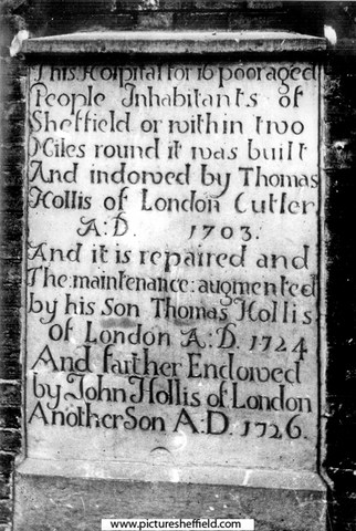
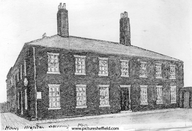
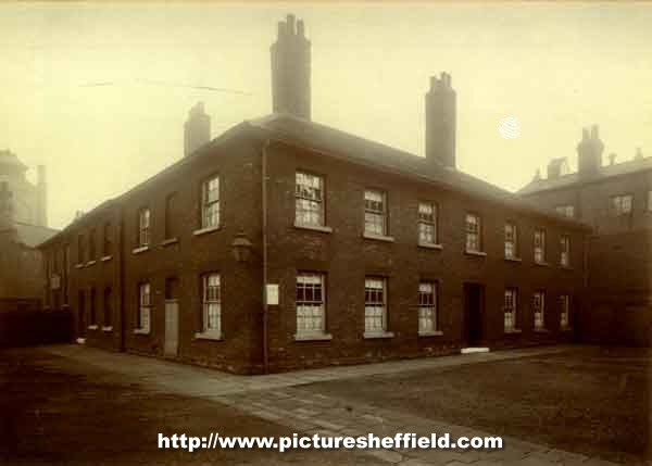
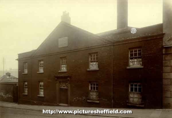
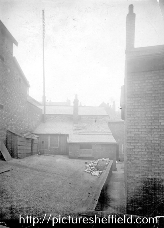
Hollis Hospital, left side fronting Bridge Street. y01867 Founded 1703 by Thomas Hollis, who purchased the first Dissenting meeting-house in Sheffield, called the New Hall and adjoining house and had it converted into 16 dwellings for poor women. Built 1776. Demolished 1901. Hollis Hospital, entrance on Newhall Street. 1900.arc02334 Photographer: Yates, Fargate. Original at Sheffield City Archives ref. MD7596/3. Hollis Hospital, inside the hospital premises; from a photograph taken across the yard. 1900.arc02335 Rear of Hollis Hospital and Schools, building on right fronts Bridge Street. Buildings on left fronts Court No. 1, Water Lane. u03278 A plan of Hollis's Hospital in Sheffield and several adjacent tenements which belong to the Trust. 1789. https://www.picturesheffield.com/frontend.php?keywords=Ref_No_increment;EQUALS;arc03803&pos=31&action=zoom&id=99474 This Plan shows position of Hollis Hospital on the extreme right. The Earl of Surrey's tenements between Bower Street and New Hall Street, [1781] https://www.picturesheffield.com/frontend.php?keywords=Ref_No_increment;EQUALS;arc04286&pos=34&action=zoom&id=105965 Shows: Bower Spring Lane, Spring Croft, Steelhouse Lane, Workhouse Lane, Hicks Lane, New Hall Street [Newhall Street], footway to Bridgehouses, Under the Water, Town Mill Wheel and Town Mill. John Hawksworth, Jno. Askwell / Ashwell, John Wainwright, Ann Genn, Joseph Frisket, Samuel Broadbent, W. Fowler, James Foulds, Thomas Fox, Widow Warrington, Samuel Matthews, Denis Belk, William Fox, John Deykin, wardens of a club, Ann Young’s heirs, George Greene, Joshua Wright, Samuel Bates, Matthew Fenton, George Greaves, Robert Dring, John Brownell, Thomas Holy’s heirs, William Booth, Ann Newton, Francis Sayles, heirs of Nicholas Hick, William Thompson, James Mellor, heirs of Samuel Smith, John Robinson, Samuel Hirst, Thomas Smith, Thomas Taylor, John Fox, Samuel Norris, John Vickers, Samuel Camm, Joseph Wildsmith, George and Philip Smilter, Mary Pashley, Joseph Ashforth, Hollis Hospital. Plaque from Hollis Hospital. y00590 Leighton in the conversation below obviously doesn't quote it word for word, but the gist of it. Edit: All is revealed in a later posts containing another Plaque and in the Hollis Hospital.org. History.... Leighton quoting from an earlier "modest but ancient building" near the Cathedral with a Plaque. Extract from articles and letters from The Sheffield and Rotherham Independent 1872/3, edited by Robert Eadon Leader 1875. "Reminiscences, it's Streets and its People." Page 111. "Leighton: Standing with its side to Newhall Street and facing Millsands is Hollis's Hospital, or, as it used commonly to be called, Brown Hospital, built on the site of the first Dissenters' Chapel in the town. Its history is to be found in Hunter's Hallamshire; but the inscription on the Newhall Street- side, over a blocked-up doorway, may be recorded here, for although there seems to be no present prospect of its obliteration, when such things do disappear there is no recovering them : — "This Hospital, for sixteen poor aged Inhabitants of Sheffield or within two Miles round it, And School for fifty children, were founded by Thomas Hollis, of London, Cutler, 1703, And further endowed by his sons,Thomas Hollis, 1724, and John Hollis, 1726, And rebuilt more commodiously by the Trustees,1776." Everard: While almost everything else round here has changed, this building remains the same, close to busy thoroughfares, and yet, as it were, removed from them. Stepping down here, only a few yards from the noisy streets, has to some extent the effect of getting into a Cathedral close." Pages 189 &190. St. Thomas's Day in Hollis Croft. "Leighton: An old Hollis Croft public-house was "The Cock." Wragg: Yes, it was once kept by the father of the Mr. Jonathan Beardshaw, who has been mentioned as landlord of the Ball, Hawley Croft. His widow and his daughter's husband, named Henderson, also kept it. Leighton: Passing down the street, a few days ago, I found myself standing opposite to the house. I was sorry to see that the Cock had lost some of the *** plumage which adorned him so well 40 or 50 years ago; yet he still holds up his crest as proud as ever, and is ready to do battle as in the days of yore against all who shall presume to poach upon his domestic domain. I thought of the days that are long gone by, and of the old song : — "Bright Chanticleer proclaims the dawn. And spangles deck the sky." Again, "My Lord, the early village cock hath thrice Bid salutation to the morn." And again, that it was St. Thomas's Day. All hail to the founders of the Hollis Hospital, from whom the Croft takes its name. They are to be found recorded within the grounds at the bottom of Snig Hill, and a full history is given in Hunter's Hallamshire. The Trustees in their wisdom, and no doubt with the best intentions, let the ground in Hollis Croft on building leases for 900 years, the front at Is. per yard, and large pieces of ground at the back for nothing. That they were generous souls is sufficiently proved by their allowing three guineas to the tenantry to enable them to enjoy a good old English dinner. It was held at the "Cock," on St. Thomas's Day, and these are the names of some of those who took a delight in attending. There were three brothers of the name of Shepherd, two of whom I knew. They were invariably together, one of them walking about a yard in advance of the other. Other two brothers were Samuel and Benjamin Marples. I had the pleasure of knowing them well — honesty and truth were in them, and when one died the other could not live; he did not long survive his friend, his companion, his brother. Now, whatever I have said in praise of the above applies equally to those I shall mention below — Mr. Philip Law, Mr. John Spencer (Matthias Spencer and Son, Pea Croft); and oh, what delight I feel when I meet his venerable figure, and look upon his cheerful countenance. He will long be remembered. Mr. Jonathan Beardshaw, of whom more anon; Mr. John Hawksley, Mr. James Wild (of whom you have heard before), Messrs. Shirtcliffe, Skinner, Barraclough (Messrs. Wingfield and Rowbotham), Benjamin Leathley, Thomas Makin, Charles Sanderson, and various others. Their descendants are still amongst us, keeping up the good names of their families. The dinner is over, the usual loyal toasts are given, the land-lord ordered; the spirits, the lemons, the sugar & etc, are brought in, and Mr, Beardshaw, in accordance with the time-honoured custom, is called to mix the punch. He consults his friends. A little more lemon, says Mr. Wild; a little more sugar, says another; and the mirth begins. Mr. Beardshaw is called upon to sing his song of the "Flat Backs": — " To mak 'em we are willin, A basket full for a shillin, Red herrins and potatoes Our bellies to be fillin." But though times were bad with them, they could still be generous with the ale, and "Pray the' gie Steen (Stephen) a sup, for he is varry dry, his throat is full of smithy sleek, the wind has been so high." Other songs followed. The old warlike ones were not forgotten. "Let the song go round, let the shouts resound, Let the trumpet sound on Spanish ground; Let the cvmbals bang, with a merry, merry clang, To the joys of the next campaign — To the joys of the next campaign." Amidst all the mirth and jollity which prevailed, one thing was never forgotten, a subscription for the poor widows of the street. It was always a liberal one, and I have no doubt carried comfort and consolation along with it. It is not always a pleasure to recall the past, but in the course of a pretty long life I have experienced a full share of bright sunshine, to which I can look back with pleasure; and some of the moments I passed on St. Thomas's Day, at the sign of the " Cock," are among these. Several of those whom I have named above could well afford to ride in their own carriages, but they were plain men, and would have felt ashamed to have been seen in them; but in these days, when wealth is accumulated by leaps and bounds. "Some drive along with four in hand. While others drive at random, In wisky-buggy, gig or dog-cart, Curricle or tandem." Twiss: When speaking of fraternal affection of Samuel and Benjamin Marples you might have added that, inseparable as they were, it was the rarest thing in the world to see them without their wives. The four were always together, and formed a most harmonious quartette." Plan of the property in Sheffield belonging to the Trustees of Hollis' Hospital let on building leases, 1855 (copied 1859) includes Hollis Croft. https://www.picturesheffield.com/frontend.php?keywords=Ref_No_increment;EQUALS;y09970&pos=27&action=zoom&id=65489 Ordnance Survey Map, sheet no. Yorkshire No. 294.7.15 1889 (Hollis Croft can be seen bottom right, The Cock P. H marked about halfway up). https://www.picturesheffield.com/frontend.php?keywords=Ref_No_increment;EQUALS;q00060&pos=63&action=zoom&id=106069 Hollis Croft Sheffield, Cock public house and mystery medieval coin. https://www.wessexarch.co.uk/news/hollis-croft-sheffield-cock-public-house-and-mystery-medieval-coin Hollis Hospital Trust, Sheffield. https://discovery.nationalarchives.gov.uk/details/c/F109998
-

Royal Oak, Norfolk Arms & Debtors Prison, King Street
Ponytail replied to Ponytail's topic in Sheffield Pubs and WMC's
The landlord of the Royal Oak, Thomas Smith was constable in 1818. The King Street Debtors Gaol was next door to the Royal Oak and Smith was head gaoler. Information from: Sheffield Public Houses, Michael Liversidge. 728.5 SQ. Pudding Lane was renamed King Street. Was the Royal Oak previously called the Norfolk Arms? A plan of the jail, Godfrey Foxs' tenement called the Norfolk’s Arms, and Joseph Hawksleys' tenements with the conveniences to each, held of the Duke of Norfolk. 1792. https://www.picturesheffield.com/frontend.php?keywords=Ref_No_increment;EQUALS;arc03632&pos=414&action=zoom&id=99173 Tenement called the Norfolk Arms and Joseph Hawksley's Tenements with the Conveniences to each situate in Kings Street and held of the Duke of Norfolk. 1793. https://www.picturesheffield.com/frontend.php?keywords=Ref_No_increment;EQUALS;arc03424&pos=412&action=zoom&id=98689 Site plan; numerical list with tenants and measurements. Property on the north side of King Street. (King Street, Debtor's Jail). Tenements in King Street held of the Duke of Norfolk by Joseph Hawksley, [1790] https://www.picturesheffield.com/frontend.php?keywords=Ref_No_increment;EQUALS;arc03631&pos=413&action=zoom&id=99172 Extract from articles and letters from The Sheffield and Rotherham Independent 1872/3, edited by Robert Eadon Leader 1875. "Reminiscences of Sheffield, it's, Streets and it's People." Pages 89-91 Johnson: In the lower part of King Street, where is now Mr. Hunt's flour shop, was formerly the father of Mr. John Jones, before he removed into the premises still occupied by his son in the Market Place. Leonard: I remember the Square just above there, now represented by Garside and Shaw's timber yard and Castle Court, where fruit and fish dealers congregated. It was called "The Green Market," and was disused after December, 1851. Everard: Ah, that market was formed on the site of the old debtors' gaol, taken down in 1818. A curious place, indeed, according to our notions. It was a stone building, not very large, the gaoler being Godfrey Fox. People were incarcerated there for ridiculously small debts, and often for alehouse scores. The prisoners used to work at their trades, and you might hear cutlers and file-cutters hammering away as if they had been in their shops. Friends brought the work and took it back again, and also supplied the prisoners with food. Leonard: The debtors then made themselves tolerably comfortable? Everard: Oh, dear yes. It was a ***** kind of imprisonment. The gaol was often thronged with visitors until nine o'clock. There was a prisoner in each room, above and below, who solicited the passers-by to "remember the poor prisoners." The one above had a tin box suspended by a string; and the other, in the lower room, with his hand through the window, held a similar box. Twiss: In 1791, at the same time that Broomhall was attacked, the mob destroyed the doors and windows of the gaol and the house of Godfrey Fox, and liberated the prisoners. It was the prison for the liberty of Hallamshire, and the property of the Duke of Norfolk. Everard: There were two classes of prisoners, the fees in what was called the "High Court" being 25s.; in the "Low Court," only 6d. There was, in addition, "garnish," 2s. 6d. for the High Court, and Is. 2d. for the Low, with which coals, candles and soap were bought for the common benefit of the prisoners. Nield, in his "Remarks on the Prisons of Yorkshire," describes his visits to the place in 1802. There was, he reported, no chaplain, nor any religious attention paid to the prisoners. Mr. Moorhouse, the surgeon to the overseers of the poor, attended to the sick. The High Court prisoners had a room about five yards square, which had two windows looking into the street. Up-stairs there were four rooms, two for men to sleep in, and one for women, the fourth being used as a workshop. The keeper furnished beds at 10d. per week, two sleeping in a bed. The Low Court prisoners, or those detained for debts under 40s. (three months' imprisonment being held to release them from their debt and costs), had two rooms, about five yards by four, with a fire-place, and iron-grated windows looking into the court. In these they worked and slept, which made them "filthy beyond description." Four rooms had lately been added at the top of the house, one of which was used for the women at night. Twiss: When Howard, the prison philanthropist, visited the place sometime before, it would seem that these upper rooms were not in existence, for he reported that there were only two rooms, which were also used as night rooms for debtors of both sexes. Leonard: Nield adds that the Low Court prisoners found their own straw and firing. The courtyard had a damp earthen floor, and was about ten yards by six. Both sexes associated together in it; and at his visit on Sunday, the 15th August, 1802, the Low Court prisoners were busy sifting cinders in it, the ashes of which they sold for three shillings a load. Everard: After Godfrey Fox, Thomas Smith, constable, was gaoler, and at the same time kept the "Royal Oak," which was next to the gaol. On the gaol being pulled down, he and the prisoners removed to the premises in Scotland Street, formerly a merchant's warehouse, with the house adjoining as his residence. Mr. Joseph Kirk succeeded him. Wragg: Thirty years ago, in one of the little market shops that then stood on the site of the old gaol, was Mrs. Horsfield, the mother of two Unitarian ministers, the Rev. T. W. Horsfield, the historian of Lewes, and the Rev. Frederick Horsfield. Debtor's Prisons. https://institutionalhistory.com/debtors-prisons/ The Law in Sheffield: From Sheffield Castle to West Bar. Aug 2021. https://sheffielder.net/2021/08/01/the-law-in-sheffield-from-sheffield-castle-to-west-bar/ -
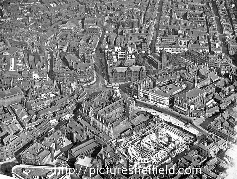
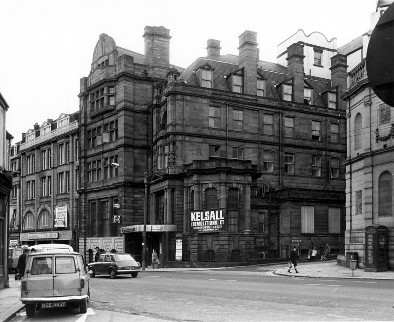
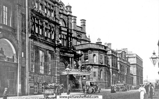
Aerial view - City Centre including City Hall (under construction) and Regent Cinema, Barker's Pool, Town Hall and St. Paul's Church, Pinstone Street, rear of Grand Hotel, Leopold Street, Fargate, on left and Surrey Street in background. 1931.s12337 Demolition in progress, Grand Hotel, Leopold Street and the junction with Orchard Lane, former Marshall and Snelgrove, fashion specialists left. January 1974.s26050
-
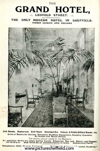
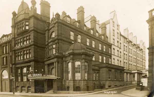
Proposed Hotel (Grand Hotel or Hotel Leopold), Leopold Street, Sheffield - Basement Plan. 1906. https://www.picturesheffield.com/frontend.php?keywords=Ref_No_increment;EQUALS;arc02091&pos=36&action=zoom&id=76243 Sections. https://www.picturesheffield.com/frontend.php?keywords=Ref_No_increment;EQUALS;arc02090&pos=35&action=zoom&id=76242 Grand Hotel, Leopold Street at the junction with (right) Orchard Lane. Postcard postmarked 1910. p01380 This image was originally part of the Tim Hale Photographic Collection. It was purchased at auction in September 2019 through donations from members of the public and a grant from the Graves Trust. Leopold Street, showing Grand Hotel, Education Committee Offices and Central Secondary Schools. 1910.s00171 Advertisement for The Grand Hotel, Leopold Street. 1916. y05275 Image from Sheffield Telegraph Year Book 1916 (page 224) (Local Studies 032.74 S).
-
The Alexandra Theatre on Blonk Street
Ponytail replied to RichardB's topic in Sheffield CInemas and Theatres
Alexandra Theatre, Blonk Street - proposed additions (ground floor plan). Shows stage, pit, dressing rooms, refreshment room, scene dock, etc. Smithfield Hotel is also marked. 22nd February 1883. https://www.picturesheffield.com/frontend.php?keywords=Ref_No_increment;EQUALS;arc04431&pos=80&action=zoom&id=151789 -
Sheffield History Public Houses A-Z: Fountain. 7 Pinfold Street Open 1822. Closed Comments 1822 address 7 Townhead Cross, 1825 address 7 Pinfold Street Also 19 Pinfold Street 1816-17 Thomas Bramley [Trippet Lane] 1822 John Richards 1825 John Richards [7 Pinfold Street ] 1828 John Richards 1830 John Richards 1833 John Richards [ 7 Pinfold Street ] 1834 Thomas Wood 1837 George Marriott 1839 Joseph Gregory [ 19 Pinfold Street ] 1841 John Greaves 1845 Eliza Housley (19 Pinstone street) 1846 Eliza Housley 1849 Elizabeth Housley 1851 Elizabeth Housley 1852 Elizabeth Housley 1854 Elizabeth Housley 1856 Elizabeth Housley 1859 W. Earnshaw 1862 William Earnshaw (19 Pinfold Street). Fountain Public House Pinfold Street. https://pubshistory.com/Yorkshire/SheffieldF/FountainPinfold.shtml
-
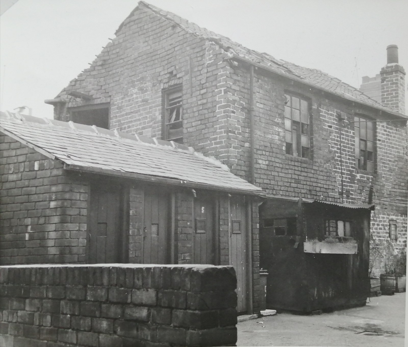
The photographs in earlier posts of housing due for demolition or in need of urgent repair you can see where donkey stoning the steps had been carried out. Even living in the shadow of the steelworks etc. and all the dirt and noise that was generated around them, they were still proud of their own home and kept it clean the best they could. Rear of No. 1 Wood Fold and back doorway of No. 175, Woodside Lane, 26th June 1957. demolished January 1960. s20695 It's unfortunate there isn't many photographs of interiors of the houses. Most of the photographs I've seen have been taken by the Council, Engineers & Surveyors Dept. or the Medical Officer of Health when reports have been needed to support the need for repair or demolition some through bomb damage but often through neglect by the Landlord. These photographs are often the only image there is of the house where they or their family lived. Sometimes only being able to say that space or the pile of bricks is all they have; or in my case the outside toilets of the neighbours. I only found that out because the City Engineers had written on the photograph identifying the derelict workshop they were attached to. From a map, discovered they were the outside toilets at the rear of Nos.1,3,5 & 7 Goulder Place, the houses were demolished some years before. "Goulder Place, workshop fronting Broughton Lane, taken 1st December 1962 by the City Engineers and Surveyors Office." The site is now part of Sheffield Arena Car Park. 1970, I took some photographs for a College project in the Carbrook area where my Grandmother had lived for a time. Demolition was well under way but there were some houses still occupied and even while demolition was going on around them, those steps were still being donkey stoned and the windows cleaned. Two ladies about their task thought I was from the Council but soon became friendlier when they discovered I wasn't. They hadn't wanted to move at first but were now looking forward to moving, and were missing their neighbours who'd already moved away.
-
The White Bear Pub, High Street, Sheffield
Ponytail replied to RichardB's topic in Sheffield Pubs and WMC's
White Bear Yard. A quote from Archives and Local Studies Study Leaflet. "Street Names of Central Sheffield." "A lane will admit some traffic; an alley has front doors in it; a jennel runs between the side walls of buildings; but a yard is a weird and wonderful thing. lt begins as the yard of an inn - the middle part of the White Bear Yard still exists as a jennel behind the Victoria Hall" Can we find more information about White Bear Inn and White Bear Yard and Walk? -
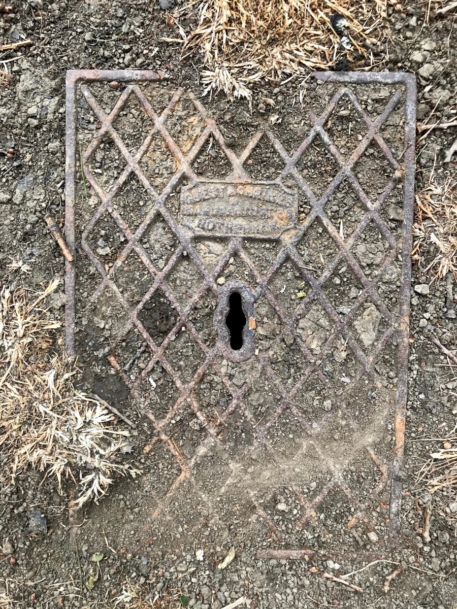
And in case you don’t have one of these yet - a Guest and Chrimes cover from Graves Park (in grass to east of north drive from main lodge on Derbyshire Lane, between the commemorative oak trees).
-
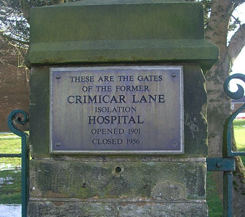
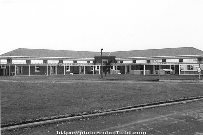
Copied from Wikipedia. "In 1955 the Board recommended that Crimicar Lane should no longer be used as a hospital and the tuberculosis Huts were demolished at that time.[2] All patients were transferred to Lodge Moor Hospital on 31 May 1956.[1] The hospital stood empty for some time before the remaining buildings were demolished to make way for the housing which now stands on Westminster Crescent. All that remains of the old hospital are the perimeter wall and the main gates which have a memorial plaque attached to them.[1]" Full Wikipedia: https://en.m.wikipedia.org/wiki/Crimicar_Lane_Hospital Crimicar Lane Hospital, Sheffield https://discovery.nationalarchives.gov.uk/details/r/2fecb3e5-bc53-4b16-96d4-5df8d95893df Including Information: Crimicar Lane Hospital and Sanatorium was opened in November 1902 for the reception of smallpox cases. It consisted of two wards, each accommodating 21 beds; an isolation block accommodating four wards each with two beds; also an administrative block, laundry and disinfector. Prior to the First World War the hospital was primarily for cases of smallpox, but consumptive (tuberculosis) patients were admitted if smallpox cases were lacking. In 1915 a temporary wooden ward was erected to accommodate 48 patients and an extension to the administrative block was built in 1916. Many patients were those associated with the cutlery industry: grindstones and buffing wheels created a huge amount of gritty dust. Silicosis was the cause of great mortality, as was tuberculosis which was often associated with the "dolly polishing" of silverware. In 1950 the hospital had accommodation for 53 patients. In 1955 the Planning Committee of Sheffield Regional Hospital Board recommended that the use of the premises as a hospital be discontinued and that the patients be moved to Lodge Moor Hospital. The buildings were to be retained pending instructions from the Ministry of Health. The patients were all transferred out of the hospital on 31 May 1956; the patients at Commonside Sanatorium also being transferred to Lodge Moor at around the same time. The hospital buildings were later demolished to make way for housing; all that remains are the part of the perimeter wall and gates (2004). Administration The hospital was administered by Hospitals Committee of Sheffield City Council, established under the Public Health Act, 1875. In 1927 this committee became a sub-committee of the Health Committee. At the establishment of the National Health Service in 1948 management, like other hospitals formerly administered by the Council, passed to the Sheffield No 3 Hospital Management Committee of Sheffield Regional Hospital Board (SRHB).
-
It seems strange, that there are photo's of the Isolation Huts & Demolition at the Crimicar Lane Hospital, yet, despite much searching, I have never found any of the Huts that were at Lodge Moor
-
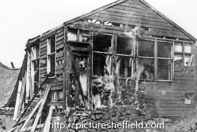
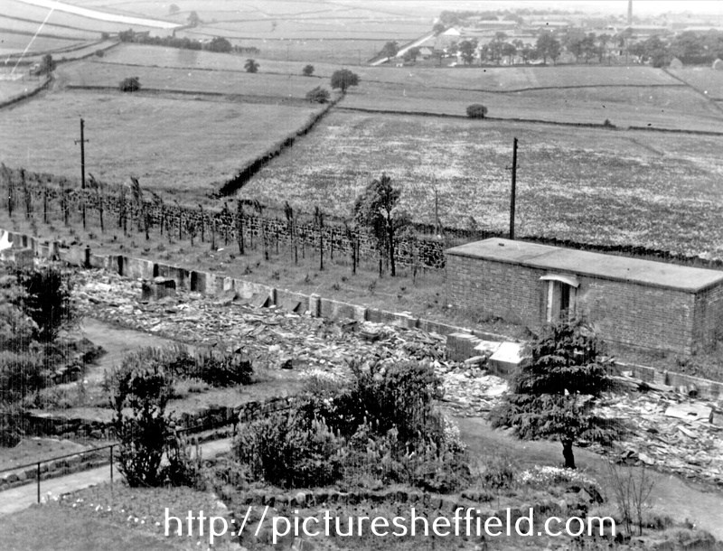
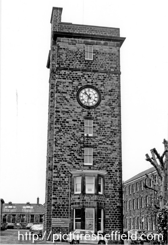
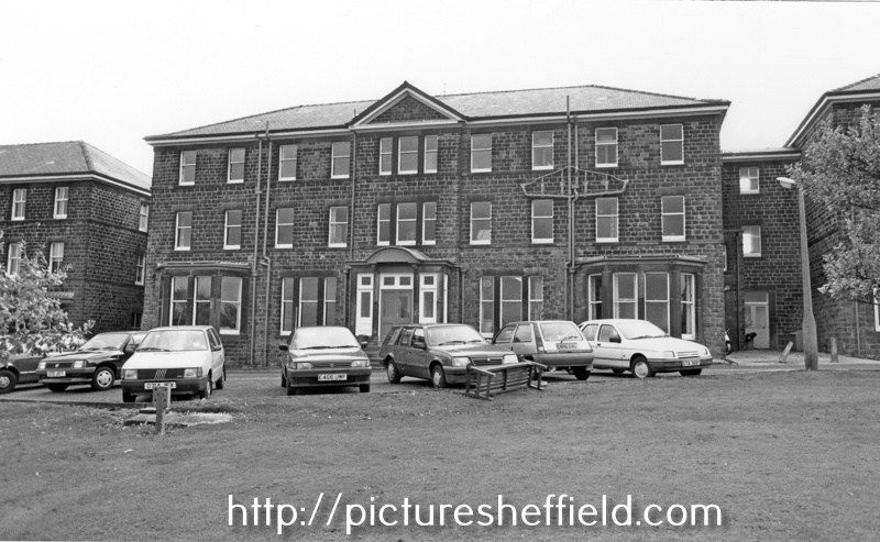
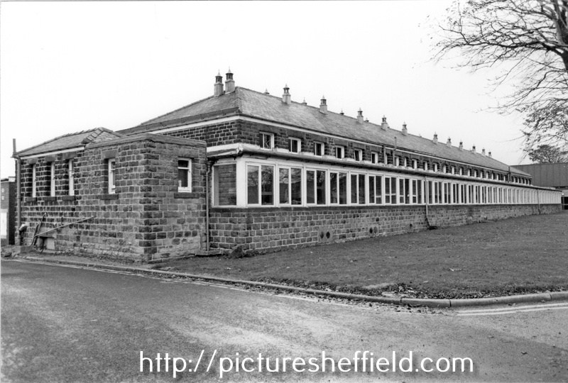
Lodge Moor Hospital was originally built in 1887, opening its 12 wooden wards on the 20th February 1888 as the Borough Smallpox Hospital. Demolition of Tuberculosis Huts, Crimicar Lane. 1955. s23386 s21093 View taken from an upstairs room of the main Crimicar Lane Isolation Hospital showing the WW2 concrete roofed air raid shelter. By June 1898 it was decided to add permanant stone buildings to comprise of accommodation for 146 patients. The administation block and isolation wards were occupied in 1901 and 6 wards each with 22 beds were completed by 1902. The Clock Tower and the Lodge at the main gates were completed in May 1903. For more information see: Lodge Moor Hospital 1887-1987, Lodge Moor Cenenary Brochure Ref: 362.11. See also The Hospital on the Moor, the spinal injuries unit Lodge Moor by Ella Goddard Ref: 362.197482. Clock Tower, Main Entrance, Lodge Moor Hospital. 30th October 1990. s23347 Administration Block, Lodge Moor Hospital. s23355 Infectious Diseases Wards (West Wards), Lodge Moor Hospitals23354 Respiratory Function Unit, Lodge Moor Hospital. s23353
-
What happened to the OPEN AIR SCHOOL RECUPERATING CHILDREN on Gloucester Crec; Broomhill
Ponytail replied to a topic in Sheffield History Chat
Springvale House Open Air School, pre-1968. s30481 This school had accommodation for 140 'delicate' pupils and was officially opened by Councillor A. Neal in October 1919. s30482 Also an entrance drive to Springvale on the OS Map 1889. 294.11.3 from Park Lane. https://maps.nls.uk/view/231282594#zoom=3&lat=7572&lon=9797&layers=BT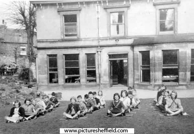
-

Dodson of Windy House and Crabtree Farms. Sheffield Park
Edmund replied to Sidney Taylor's topic in Sheffield History Chat
William West occupant of Windy Hill Farm, gave up farming in November 1864, he died aged 69 at the Shrewsbury Hospital in June 1867. In 1865 W Hodgson was the occupant (no sign of any sale of the farm itself). In March 1868 William Dodson was the occupant (he had some brasses from a threshing machine stolen by an employee). In November 1890 the Norton Ploughing Association met at the Bagshawe Arms to present William Dodson with a silver cup, as first prize for the best cultivated farm within six miles of Norton. In October 1891 William decided that he was leaving the neighbourhood and advertised all his live and dead stock for sale - this included 4 horses, 18 cattle and 20 sheep. In 1892 J.H. Bryars, a veterinary surgeon, was the occupant of Windy House Farm. Again there was no notice of sale, so the farm was presumably rented. In January 1891 William saw a man in his brother Edward's field in Strawberry Lane, Darnall, with a gun. He challenged him and the man presented a game licence in someone else's name. The man raised his gun and looking along the barrel said "If you come a step further I shall blow out your brains". The muzzle of the gun was about a yard from William's chest. He swept his stick up and knocked the gun upwards, whereupon it went off. In May, the man (William Siddall) was fined 30s and costs for the trespass and for threatening Mr Dodson he was bound over to keep the peace for 6 months, On leaving Windy House, William Dodson went to farm at Sprotbrough ("The Shires"), with his brother (?) John an agricultural horseman on the farm. William became a Justice of the Peace, Chairman of the Council in 1915-16 and was prominent in the foundation of the National Farmers Union. He died in a Doncaster nursing home in March 1929. He was twice married (Eliza died aged 44 in June 1877), and he left a widow (Elizabeth) and one son. -
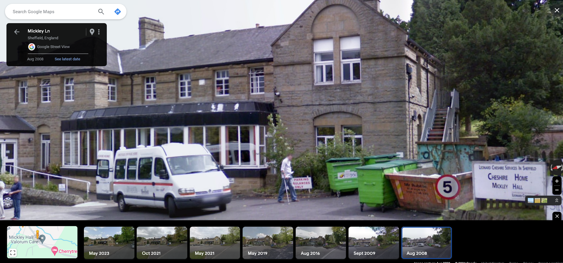
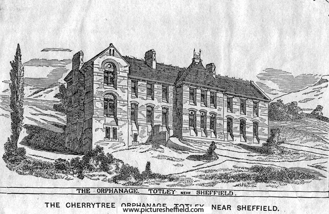
Cherrytree Orphanage, Mickley Lane, became a Leonard Cheshire care homre

-
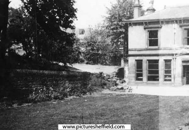
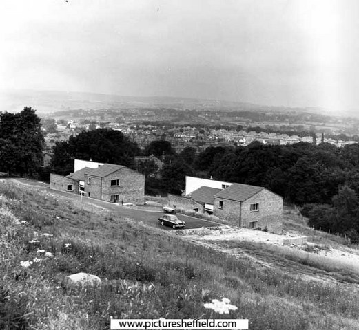
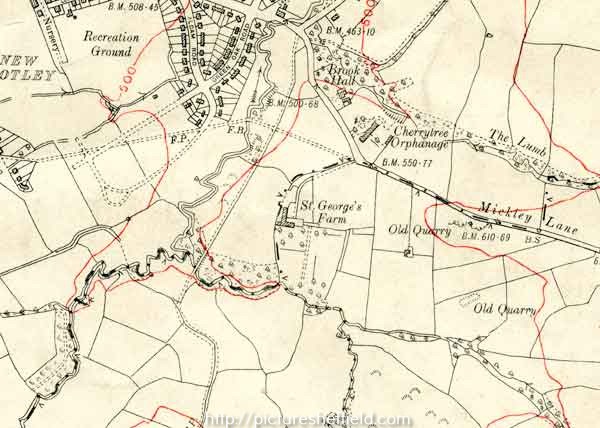
Cherrytree Orphanage, Mickley Lane, Totley. Founded in Sheffield about 1863 by E.P. Taylor, Esq. Foundation stone laid 21st August, 1867 by John Webster Esq., Mayor of Sheffield. Total cost £4,000. 1872. s07784 Picture taken from the 8th report, 1872. In 1868, Mr Taylor, transferred the property to trustees. The institution, which was supported by voluntary subscriptions and a Goverment grant, had for its objects the boarding, clothing, and education of poor children who had been deprived of both their parents, irrespective of religious belief ot nationality. Miss Stronach was matron in 1906. Cherrytree Orphanage, Mickley Lane, Totley. 1963. https://www.picturesheffield.com/frontend.php?keywords=Ref_No_increment;EQUALS;s35076&pos=2&action=zoom&id=70519 Cherrytree Homes, Mickley Laneu06868 Buildings used to house 1 carer and around 6 children, built around 1969. Once completed the original Cherrytree orphanage was subsequently turned into an old peoples home (Information care of Sharon Parkinson). Presentation to Cherrytree Orphanage, Mickley Lane. 14th February 1967. https://www.picturesheffield.com/frontend.php?keywords=Ref_No_increment;EQUALS;s07784&pos=5&action=zoom&id=11019 OS Map dated 1935, showing Cherrytree Orphanage & St George's Farm, one time home of John Ruskin. y12786
-
Dodson of Windy House and Crabtree Farms. Sheffield Park
Ponytail replied to Sidney Taylor's topic in Sheffield History Chat
Link to: Manor Road Names. Question asked how did Windyhouse Lane get its name. https://www.sheffieldhistory.co.uk/forums/topic/5470-manor-road-names/ -
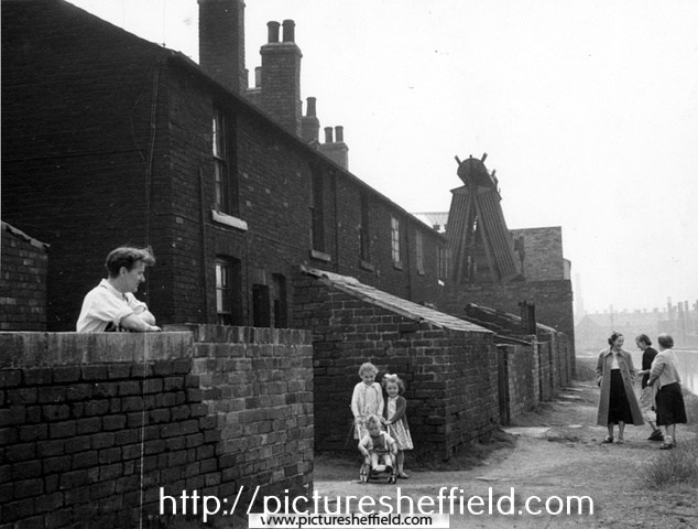
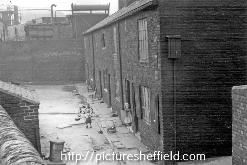
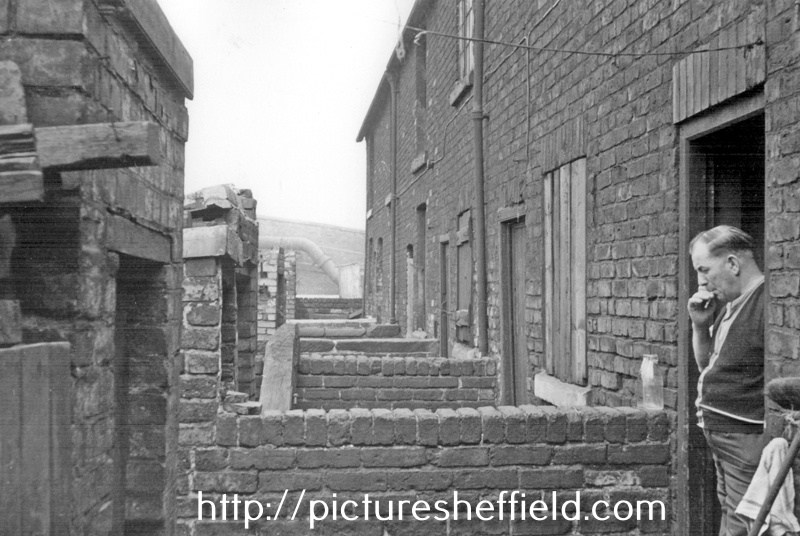
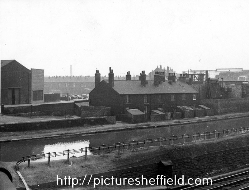
Canal Cottages, Tinsley Park Road (demolished 1958) showing the Electricity Sub Station (right) and Sheffield and SYK Navigation from Broughton Lane Bridge. Photographs taken 8th May 1957 by Kodak Medical, Medical Officer of Health. Llewellyn Roberts. Properties demolished 1958. s24779 Mr. Vincent Lawrence Bryan with his children Stephen John; Kathleen and Pauline Mary in front of Nos. 7-12, Canal Cottages, Tinsley Park Road with the Sheffield and SYK Navigation right. s24778 The Bryan Family children who lived at No. 5 showing Nos. 6-1, Canal Cottages, Tinsley Park Road, looking towards Electric Sub Station and Chemical Works.t00515 Information from Stephen Bryan who can be seen, aged around 18 months, with his sister Kathleen aged about 4 years. Stephen loved to play with the brush in the puddle that frequently gathered in the yard. Mr. Vincent Lawrence Bryan in the doorway of No. 12 and Nos.11-7, Canal Cottages, looking towards Broughton Lane Bridge. t00514
-
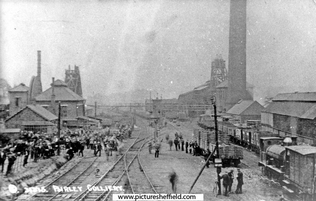
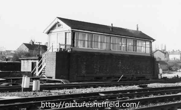
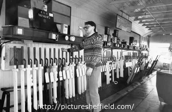
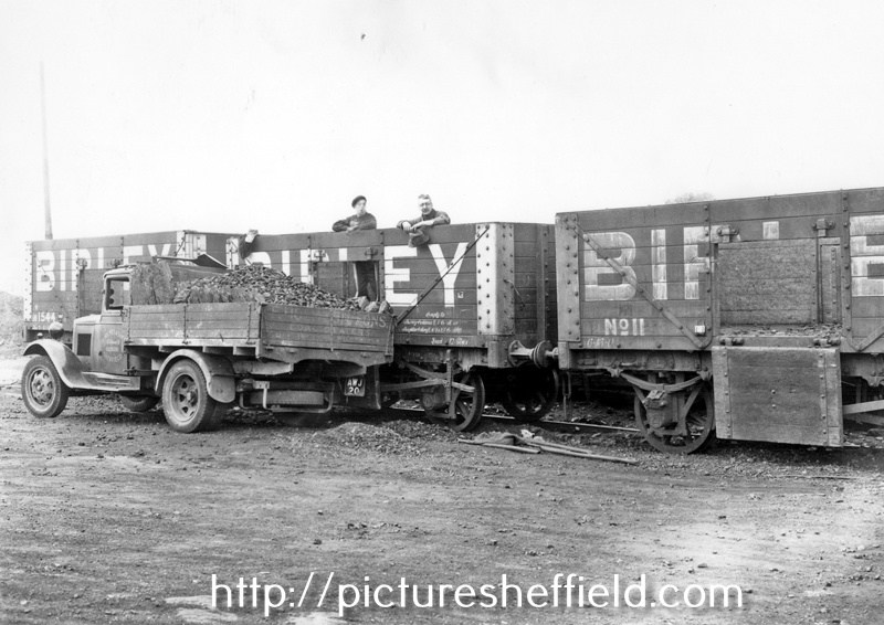
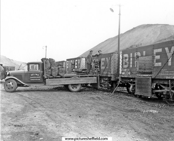
Birley Collieries Branch Line
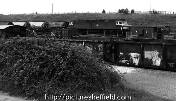
Ponytail replied to Paolo Coopio's topic in Sheffield Buses, Trams and Trains
Woodhouse Junction signal box. 1978. https://www.picturesheffield.com/frontend.php?keywords=Ref_No_increment;EQUALS;s41720&pos=45&action=zoom&id=81661 Woodhouse Junction Signal Box.13th May 1981.s41716 The wall at the base was built during the war to protect the original structure. 21st February 1989s41717 Woodhouse Junction signal box. 21st February 1989.s41721 Track repair equipment at Woodhouse Junction. 13th May 1981. https://www.picturesheffield.com/frontend.php?keywords=Ref_No_increment;EQUALS;s42766&pos=34&action=zoom&id=83648 Diesel locomotive towing coal trucks at Woodhouse Junction. 13th May 1981. s42769 Further information from J Thickitt: Formerly known as Woodhouse East Junction, where trains towards Lincoln or Grimsby had diverged eastwards from the ex-Great Central Railway main line (closed as a through route in 1966). Among the differences to image reference number s42768 (which was photographed on the same day) are the obviously full Merry-go-Round hoppers hauled by a different class of locomotive. Diesels had been re-numbered during the early-1970s, this one becoming a member of Class 47 (the identification is deduced by the presence of a ventilation-cowl above the windscreen, here viewed in silhouette, see u09073) The taller, brown vehicle extreme left on the nearest track was known on the railway as a van (meaning a covered waggon). s42768 Diesel locomotive towing coal trucks at Woodhouse East Junction. https://www.picturesheffield.com/frontend.php?keywords=Ref_No_increment;EQUALS;s42768&pos=36&action=zoom&id=83650 Mr Thickitt refers to Picture Sheffield No. u09073. https://www.picturesheffield.com/frontend.php?keywords=Ref_No_increment;EQUALS;u09073&pos=2&action=zoom&id=95913
-
Birley Collieries Branch Line
Ponytail replied to Paolo Coopio's topic in Sheffield Buses, Trams and Trains
Colliery Engine 'Birley No. 5', most probably at Beighton Colliery Sheffield Coal Co.s15051 Hudswell Clarke 0. 6. 0 ST 'Orient', shunting locomotive built for Birley East Colliery. 1890. https://www.picturesheffield.com/frontend.php?keywords=Ref_No_increment;EQUALS;v00054&pos=32&action=zoom&id=41924 Colliery Engine 'Birley No. 6, Peckett 0. 4. 0 St' and Coal Wagons at Brookhouse Colliery with Water Cooling Tower in the background. 31st March 1938. s15047 Built Bristol 1925 Works No. 1653 Colliery Engine 'Birley No. 6, Peckett 0. 4. 0 St' and Coal Wagons at Brookhouse Colliery. 31st March 1938.s15046 Steam Locomotive W D G Peckett 0. 6. 0 ST at Brookhouse Colliery. 1956. https://www.picturesheffield.com/frontend.php?keywords=Ref_No_increment;EQUALS;v00057&pos=9&action=zoom&id=41927 Steam Locomotive Hudsweel Clarke 0. 6. 0 ST 'Orient' at Brookhouse Colliery. 1956. https://www.picturesheffield.com/frontend.php?keywords=Ref_No_increment;EQUALS;v00055&pos=8&action=zoom&id=41925 Steam locomotive T R G at Brookhouse Colliery. 26th November 1966. https://www.picturesheffield.com/frontend.php?keywords=Ref_No_increment;EQUALS;v00056&pos=2&action=zoom&id=41926 Reminiscences from John A Thickett: 23 November 1966, a Saturday afternoon, saw me loafing beside the ex-Midland Railway line at Beighton. The reason was to see a railway enthusiast's special (in this context meaning an excursion) on its way towards Rotherham. During my wait I was surprised to see activity on a different line, about a quarter of a mile to the south of my position. An anonymous, shining-green tank-engine hauling open waggons was carefully negotiating a steep descent in the Rother Valley (see the white gate visible in s35507). After a while the same engine stormed sure-footedly back with another rake of waggons, this time empty. The waggons all had the initials 'U.C.C.' (United Coke and chemicals) painted in white on their sides. A minute or so later I heard the engine suddenly shut-off, no doubt because at its summit the climb had eased into level ground. These out and back runs occurred several times during my sojourn here. Mr Thickitt watched this activity for several hours from beside the main line railway/Chesterfield Road. Photo Mr. Thickitt refers to s35507 Beighton Castle area in the 1950s View northwards showing, gently curving away through the centre of the photograph, the largely freight-only, ex-Midland Railway Old Road . (The line running between Chesterfield and Rotherham, which was built years before the route through Sheffield city centre). Note this line has four tracks. On the left skyline a viaduct carried the ex-Great Central Railway's Sheffield to Lincoln line over the Old Road and the River Rother. To the right of the line towards Rotherham, the 'North Staveley Curve' leaves eastwards, perhaps still to access North Staveley Pit. On the 1:25000 Ordnance Survey map, surveyed during the 1950s, the line continued eastwards into Brookhouse Pit yard. (This line should not be confused with the out of picture but nearby, ex-Great Central Railway 'Waleswood Curve). The focal point of the scene, an eye-catching, white gate identified the boundary of a private-owner line. In this case operated (in the mid-1960s) by United Coke and Chemicals and leading (along a short, steep ascent) further east to Beighton Coking Plant. (this Beighton site was beside Brookhouse Pit and some distance from Orgreave Coking Plant). Further left, in the mid-ground to the west of the river was the Ex-Great Central Main Line (not visible) with Beighton Station not far ahead. Observe the bridge over the River Rother; a footpath across this had been reassuringly walled-off from the railway track! The river itself shows a vertical deep bank suggesting the Rother had already been canalized and embanked to prevent flooding. These works possibly occurred during the 1950s. Beyond the white gate, the sheet of water was probably a flash , the local name for a pond or lake formed by mining subsidence. Housing puncturing the skyline was on Park Hill, Swallownest. Information from J Thickitt.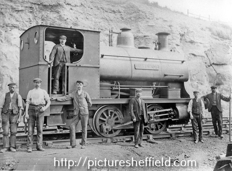

-
Birley Collieries Branch Line
Ponytail replied to Paolo Coopio's topic in Sheffield Buses, Trams and Trains
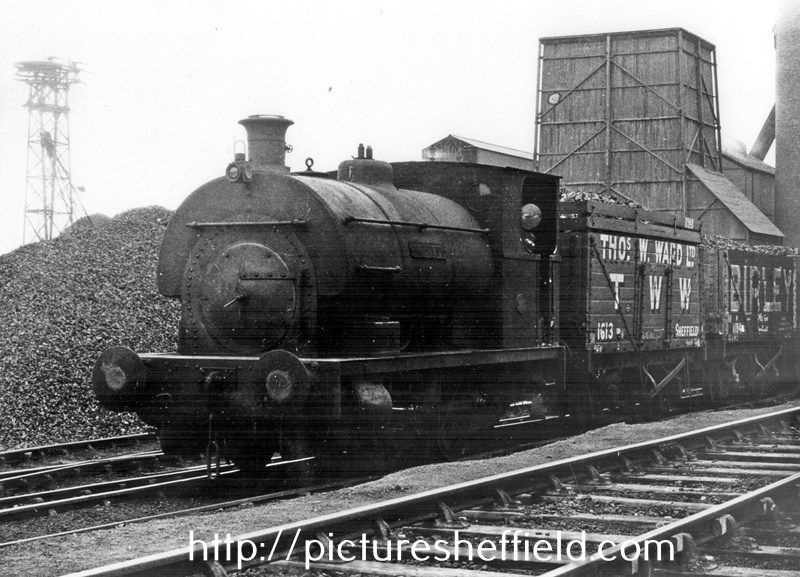
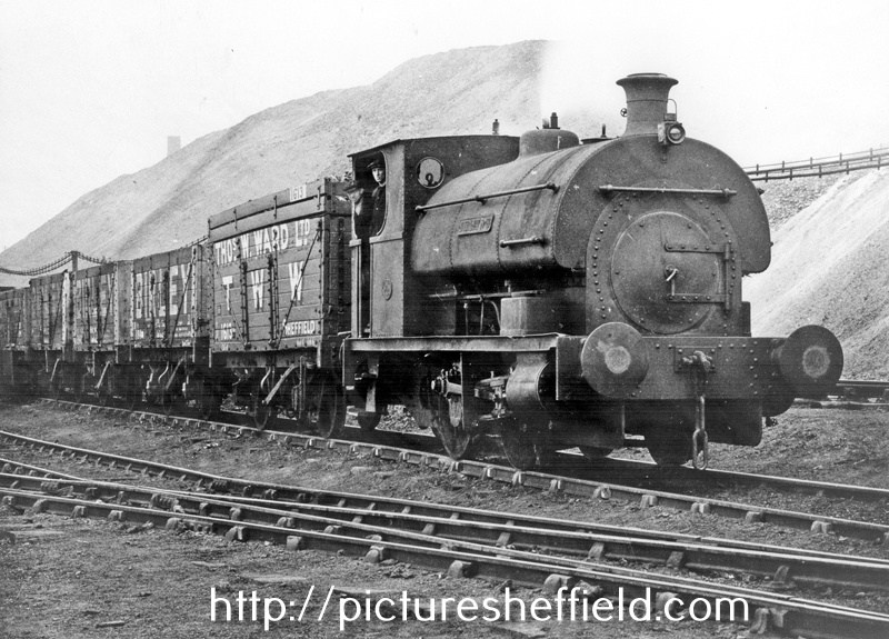
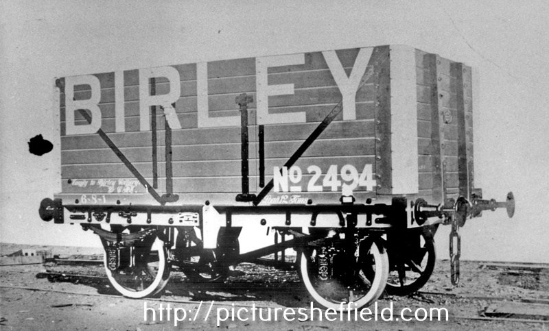
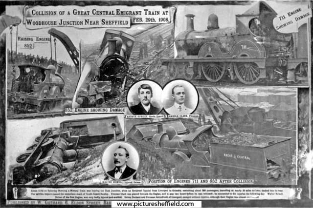
Derailed wagons at Woodhouse Mill after the crash. 29th February 1908.s03808 About 12-45 on Saturday morning, a Mineral Train was leaving the East Junction, when an Emigrant Special from Liverpool to Grimsby, containing about 300 passengers, travelling at nearly 30 miles an hour, dashed into its rear.The terrible impact caused the immediate death of Goods Guard Rowley. Fireman Clark was pinned beneath the Engine, and it was two hours before he was released: he succumbed to his injuries the following day.Walter Howell, Driver of the first engine, was very badly injured and scalded. Driver Borland and Fireman Jarred both of Liverpool, escaped without injuries, although their engine was almost overturned. For more information about Birley East Colliery see: Winding Up a History of Birley East Colliery, A Rowles Ref: 622.33 SQ. https://www.picturesheffield.com/frontend.php?keywords=Ref_No_increment;EQUALS;s03809&pos=57&action=zoom&id=7398 https://www.picturesheffield.com/frontend.php?keywords=Ref_No_increment;EQUALS;s03810&pos=58&action=zoom&id=7399 Train Crash at Woodhouse Junction. 29th February 1908. Photographer: W. Gothard s03778 Train crash on the Birley Colliery Line. 1919. s03807 Coal Wagon at Birley West Pit. 31st March 1938.s15045 Birley West Pit, unloading coal wagon. 31st March 1938.s02331 PhotographerT.Ws02331. Ward and Co. Birley Colliery Mineral Wagon No. 2494, taken at wagon shop. s15037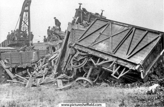

-
Birley Collieries Branch Line
Ponytail replied to Paolo Coopio's topic in Sheffield Buses, Trams and Trains
Map of Woodhouse junction area, c. 1855. Includes Green Gate Lane; Birley Vale Branch Railway, Beighton Branch Railway, Manchester Sheffield and Lincolnshire Railway; River Rother; Woodhouse Colliery; Woodhouse Mills; Shirecliffe Brook; Cinderhill Green Road; Furnace Lane, Woodhouse Junction Station; shaft. https://www.picturesheffield.com/frontend.php?keywords=Ref_No_increment;EQUALS;arc02940&pos=40&action=zoom&id=93148 Woodhouse (extract from Ordnance Survey of 1935, revised to 1948) https://www.picturesheffield.com/frontend.php?keywords=Ref_No_increment;EQUALS;y06745&pos=12&action=zoom&id=59925 Derbyshire sheet XII NE and Yorkshire CCXCV. Birley East Colliery, Woodhouses10732 For more information about Birley East Colliery see: Winding Up a History of Birley East Colliery, A Rowles Ref: 622.33 SQ. https://www.picturesheffield.com/frontend.php?keywords=Ref_No_increment;EQUALS;s10733&pos=42&action=zoom&id=13859 Viewed from Hackenthorpe side. https://www.picturesheffield.com/frontend.php?keywords=Ref_No_increment;EQUALS;s10735&pos=44&action=zoom&id=13861 East Birley Pit, late 19th century, view from Sally Clarkes. https://www.picturesheffield.com/frontend.php?keywords=Ref_No_increment;EQUALS;t00216&pos=47&action=zoom&id=31083