Search the Community
Showing results for 'coal pit lane'.
-
 George Mills, fellmonger & leather dresser, Fellmongers Works, Neepsend Lane; Leather Mills, Twelve O'Clock & Warehouse, No. 8 Dixon Lane. Advertisement from Illustrated Guide to Sheffield, Pawson and Brailsford. 1862 1852 Directory Mills, George, Spanish, Morocco and oil leather dresser and vellum and parchment manufacturer. 8 Dixon Lane and Walk Mill Mills, Samuel, fellmonger & leather dresser, New Market & Neepsend A source to explore... Folded vellum document Queen Victoria Royal Seal Probate Wakefield. George Mills, fellmonger of Sheffield, Will dated 4th November 1861, testate date 4th September 1865. Will proved Wakefield 7th October 1865 https://www.chiltonbooks.online/product/2739571/Probate-of-the-Will-of-George-Mills-Sheffield-Yorkshire
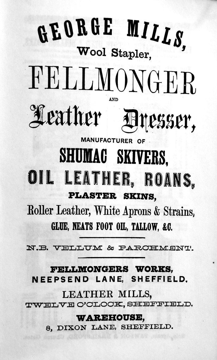
-
I'm sure Rose's was there in the 1950's but the only "Smiths" I remember was on Bellhouse Road going down to Nethershire. If my memory serves correctly there were 2 brothers so one may have had a shop at Firth Park end. Seem to think one was called Jimmy. Their mother lived next door to us on Bellhouse Road in the 1950's/60's. She had the sweetshop next to Hatfield House Lane I & J School and their dad (named Jim?) not a well man, I think was of retiring age and must have worked for the council because he used to tend the flower beds at the school. Don't think he was ever in the shop trade possibly an ex-steelworker.
-

Birley Collieries Branch Line
boginspro replied to Paolo Coopio's topic in Sheffield Buses, Trams and Trains
Great stuff, I walked that line many times, in the 50s/60s, from The Red Hills / Birley West site all the way to Birley East but had totally forgotten about that bridge. This brought back many memories of this area but looking it up now is very disappointing. Back then you could learn a lot from the historic remains easily found by just walking around., A friend of mine still lived in the valley below Birley East Pit. Now what looks like indiscriminate planting of so many trees has masked a lot of the history. If I ever get back there I would love to search for some of the remains that I do remember. ----------------------- -
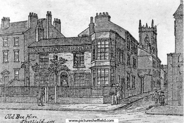
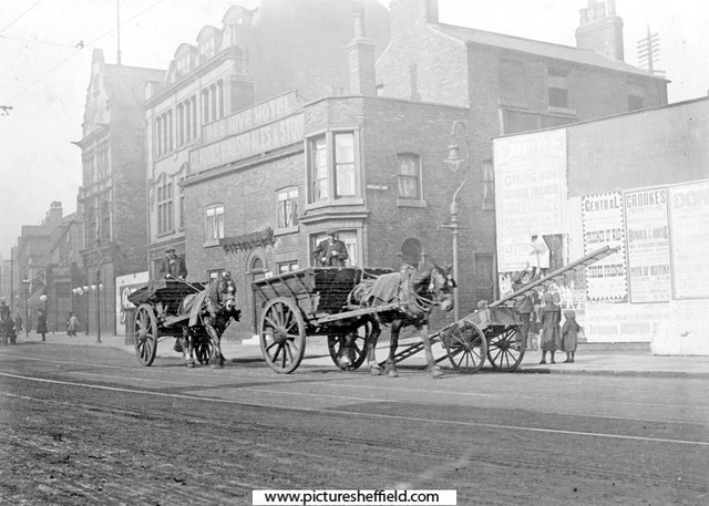
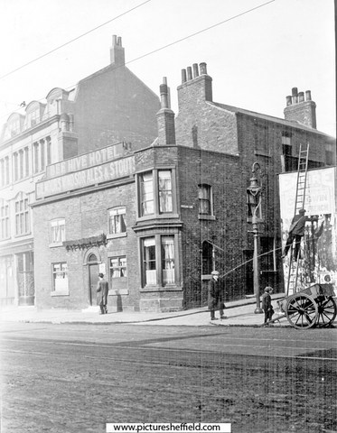
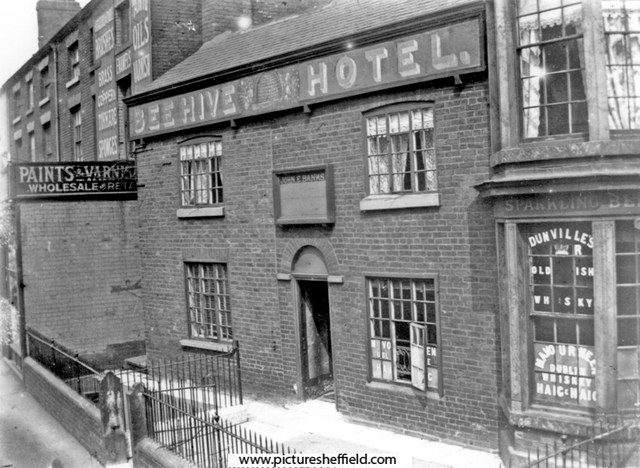
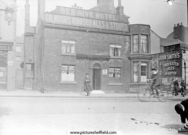
Artists Impression of the Bee Hive Hotel, No 240, West Street. Portland Lane, right. St. George's Church in background. The railings were there 1870-1880.s06859 Extract from: Reminiscences of old Sheffield, it's Street and its People. Editor Robert Eadon Leader, from articles and letters in The Sheffield and Rotherham Independent 1872/3. Page 155. "I well remember the time when the house, now enlarged and occupied as the Bee Hive public-house, was built in the cross garden walk (now Glossop Road) just mentioned, which terminated at the top of Broomhall Street. (then called Black Lamb Lane) It was erected by a shoemaker, named Thomas Rose. He was a little man, wore top boots, and kept a hive of bees in the garden beside the house. He got a license for the house and called it the Bee Hive. His pear tree (in the sketch) on the front yet retains enough vitality to show yearly a few leaves. With the exception of the old houses with gardens and palisades at the top of West Street, and the large house in Broomhall Street, beside which until lately the rooks have built, there were, I believe, no houses (except some garden cottages) from Portobello down to Holy Green, and the top of Bright, Gaol, and Young Streets. All the intervening space was occupied with fields and gardens." It was in 1817 that the Town Trustees agreed to lend towards the making of a Turnpike Road from Glossop to Sheffield providing the said road enters the town through West Street. and as the Beehive was earlier than Glossop Road we can fix the date of its erection somewhere in the opening years of the nineteenth century. s00470 Photographer: B E Drury There was also stabling to the rear. Photographs by C H. Lea of the Bee Hive Hotel in 1913.y01684 Night soil carts passing the Beehve Hotel, Portland Lane, right. Night Soil Carts collected the human waste from the Earth Closets, Water Closets (WC's) gradually replaced them. y01682 A Bill Poster on West Street at the junction with Portland Lane; balancing on his ladder across from the Beehive Hotel. y01683 Ordnance Survey Map, sheet no. Yorkshire No. 294.7.25. 1889. Bee Hive Hotel top left. https://www.picturesheffield.com/frontend.php?keywords=Ref_No_increment;EQUALS;q00075&pos=7&action=zoom&id=107161 Bee Hive Hotel, 10th February 1982. https://www.picturesheffield.com/frontend.php?keywords=Ref_No_increment;EQUALS;s21408&pos=3&action=zoom&id=24014 In the 1990s, The Bee Hive was extended and renamed the Foundry and Firkin. No 248, West Street Post Office, (later incorporated into the Foundry and Firkin) https://www.picturesheffield.com/frontend.php?keywords=Ref_No_increment;EQUALS;t09986&pos=3&action=zoom&id=90513
-
Birley Collieries Branch Line
Ponytail replied to Paolo Coopio's topic in Sheffield Buses, Trams and Trains
Map of Woodhouse junction area, c. 1855. Includes Green Gate Lane; Birley Vale Branch Railway, Beighton Branch Railway, Manchester Sheffield and Lincolnshire Railway; River Rother; Woodhouse Colliery; Woodhouse Mills; Shirecliffe Brook; Cinderhill Green Road; Furnace Lane, Woodhouse Junction Station; shaft. https://www.picturesheffield.com/frontend.php?keywords=Ref_No_increment;EQUALS;arc02940&pos=40&action=zoom&id=93148 Woodhouse (extract from Ordnance Survey of 1935, revised to 1948) https://www.picturesheffield.com/frontend.php?keywords=Ref_No_increment;EQUALS;y06745&pos=12&action=zoom&id=59925 Derbyshire sheet XII NE and Yorkshire CCXCV. Birley East Colliery, Woodhouses10732 For more information about Birley East Colliery see: Winding Up a History of Birley East Colliery, A Rowles Ref: 622.33 SQ. https://www.picturesheffield.com/frontend.php?keywords=Ref_No_increment;EQUALS;s10733&pos=42&action=zoom&id=13859 Viewed from Hackenthorpe side. https://www.picturesheffield.com/frontend.php?keywords=Ref_No_increment;EQUALS;s10735&pos=44&action=zoom&id=13861 East Birley Pit, late 19th century, view from Sally Clarkes. https://www.picturesheffield.com/frontend.php?keywords=Ref_No_increment;EQUALS;t00216&pos=47&action=zoom&id=31083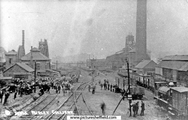
-
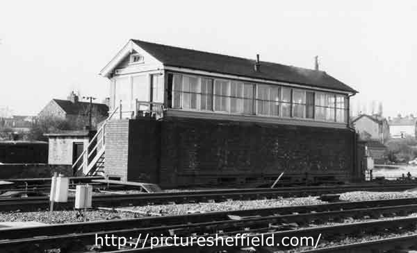
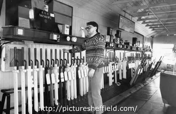
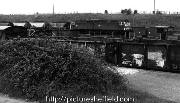
Birley Collieries Branch Line
Ponytail replied to Paolo Coopio's topic in Sheffield Buses, Trams and Trains
Woodhouse Junction signal box. 1978. https://www.picturesheffield.com/frontend.php?keywords=Ref_No_increment;EQUALS;s41720&pos=45&action=zoom&id=81661 Woodhouse Junction Signal Box.13th May 1981.s41716 The wall at the base was built during the war to protect the original structure. 21st February 1989s41717 Woodhouse Junction signal box. 21st February 1989.s41721 Track repair equipment at Woodhouse Junction. 13th May 1981. https://www.picturesheffield.com/frontend.php?keywords=Ref_No_increment;EQUALS;s42766&pos=34&action=zoom&id=83648 Diesel locomotive towing coal trucks at Woodhouse Junction. 13th May 1981. s42769 Further information from J Thickitt: Formerly known as Woodhouse East Junction, where trains towards Lincoln or Grimsby had diverged eastwards from the ex-Great Central Railway main line (closed as a through route in 1966). Among the differences to image reference number s42768 (which was photographed on the same day) are the obviously full Merry-go-Round hoppers hauled by a different class of locomotive. Diesels had been re-numbered during the early-1970s, this one becoming a member of Class 47 (the identification is deduced by the presence of a ventilation-cowl above the windscreen, here viewed in silhouette, see u09073) The taller, brown vehicle extreme left on the nearest track was known on the railway as a van (meaning a covered waggon). s42768 Diesel locomotive towing coal trucks at Woodhouse East Junction. https://www.picturesheffield.com/frontend.php?keywords=Ref_No_increment;EQUALS;s42768&pos=36&action=zoom&id=83650 Mr Thickitt refers to Picture Sheffield No. u09073. https://www.picturesheffield.com/frontend.php?keywords=Ref_No_increment;EQUALS;u09073&pos=2&action=zoom&id=95913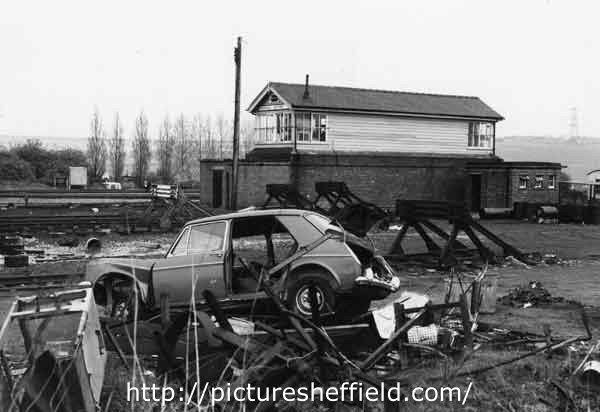
-
We already have a thread on the tramway that John Curr may have been associated with in the transport forum here. But I think that he qualifies as a Sheffield celebrity of sorts. Born in about 1756 in County Durham he moved to Sheffield some time before 1776. Eventually he became the manager of the Duke of Norfolk's Sheffield collieries. He married Hannah Wilson (18 May 1759 - 10 June 1851) in about 1785 and they had at least eight children: Elizabeth Curr (1782 - 1812) John Curr (1783 - 1860), emigrated to New South Wales. Author of Railway locomotion and steam navigation: their principles and practice Mary Ann Curr (1786 - 1868) - married Louis Armand Beauvoisin In 1822 (info from Beauvoisin) Teresa Curr (1790 - ?) Rev. Joseph Richard Curr, baptized at Sheffield 14 April 1793. Died at Leeds 30 June 1847 Harriet (Gertrude) Curr, born in Sheffield 2 Sept. 1795 and baptized four days later at the Catholic Chapel there. Died 30 May 1868. Nun of the Institute of Mary at York Edward Charles Curr (1 July 1798 - 16 November 1850), also emigrated to New South Wales, Secretary of the Van Diemen's Land Company 1824 - 1841. Married Elizabeth Micklethwaite at Sheffield and had 11 children. Author of Account of the Colony of Van Diemen's Land (factlet: the town of Sheffield in Tasmania was named by Edward Curr after his hometown) Juliana Curr (1800 - ?), married Thomas Ellison at Winwick parish church on 13 October 1828; may have also married a Beauvoisin (info from Beauvoisin) He made a number of innovations in coal mining/railway technology whilst at Sheffield, some of which are described in his 1797 book The Coal Viewer, and Engine Builder's Practical Companion. He died at Belle Vue in Sheffield on 27 January 1823. He was catholic and was buried at the catholic chapel which preceded St. Marie's church on Norfolk Row.
-
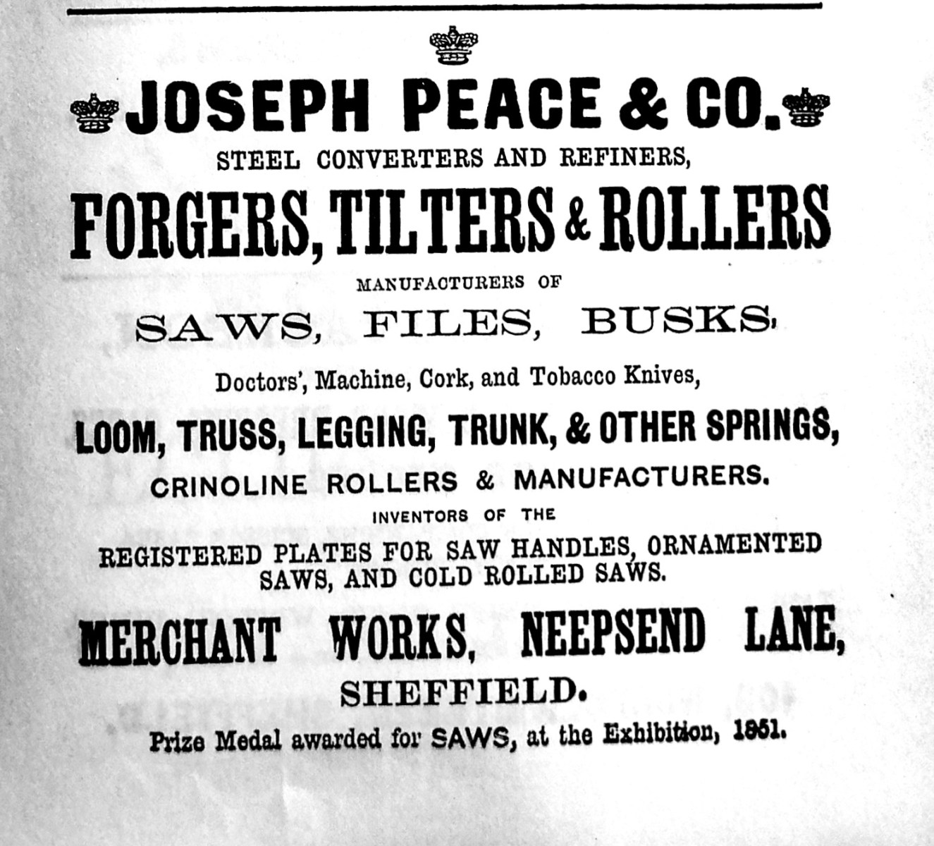
Joseph Peace & Co., Merchant Works Neepsend Lane. From Advertisement Illustrated Guide to Sheffield, Pawson and Brailsford 1862 1858 Company Registered 1918 Incorporated in Sheffield Steel Products Ltd. https://www.gracesguide.co.uk/Joseph_Peace_and_Co
-
Unidentified Public Houses and Refreshment Rooms
Ponytail replied to Ponytail's topic in Sheffield History Chat
Thank you. Adding more images of Hawley Lane, Hawley Croft etc. Hawley Lane May 1898u09591 2 images of: Derelict Property corner of Hawley Croft & Hawley Lane. https://www.picturesheffield.com/frontend.php?keywords=Ref_No_increment;EQUALS;u01119&pos=49&action=zoom&id=36842 https://www.picturesheffield.com/frontend.php?keywords=Ref_No_increment;EQUALS;u01131&pos=50&action=zoom&id=36854 Old Reindeer public house (sign on lamp left) and properties, Hawley Lane. Date Period 1851-1899 Copyright: Jill Dalton Notes. 1893-4 Directory- No. 5 Hawley Lane, James Sharp, beerhouse 1898- No. 5 John Plant, beerhouse 1902 no beerhouse listed Hawley Lane not listed 1906. https://www.picturesheffield.com/frontend.php?keywords=Ref_No_increment;EQUALS;v00922&pos=33&action=zoom&id=42714 Yard behind Becketts, Hawley Lane, possibly corner of Hawley Lane and Hawley Croft. September 1898. https://www.picturesheffield.com/frontend.php?keywords=Ref_No_increment;EQUALS;u01083&pos=32&action=zoom&id=36810 Hawley Lane. https://www.picturesheffield.com/frontend.php?keywords=Ref_No_increment;EQUALS;u09585&pos=35&action=zoom&id=56361 Campo Lane at junction with Hawley Croft, Reuben's Head public house on right. https://www.picturesheffield.com/frontend.php?keywords=Ref_No_increment;EQUALS;s02170&pos=31&action=zoom&id=5963 Corner of Hawley Croft and Campo Lane, showing sign for Reubens Head. https://www.picturesheffield.com/frontend.php?keywords=Ref_No_increment;EQUALS;u01097&pos=29&action=zoom&id=36822
-
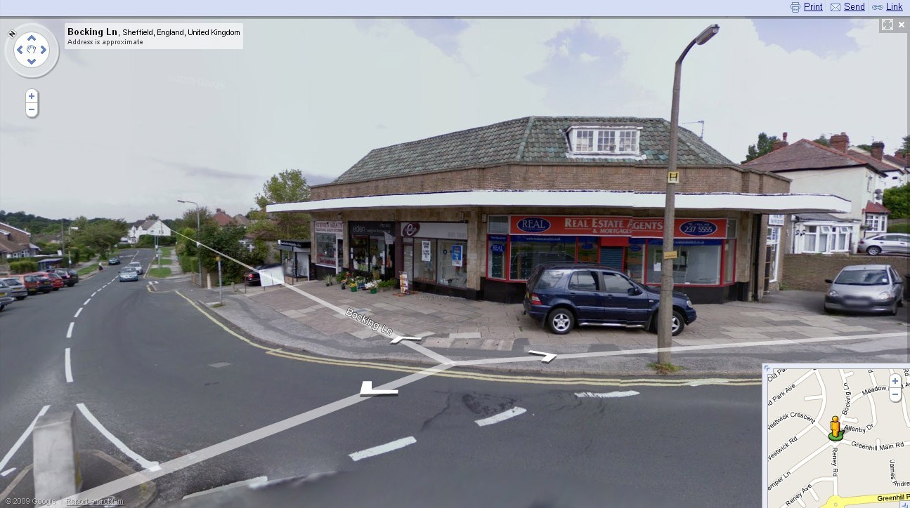
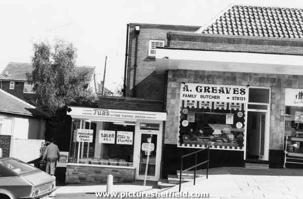
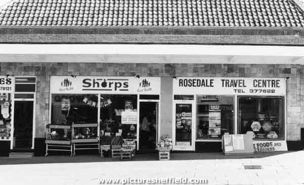
Bocking Lane. Not sure which of the above shops was the Co-op Shop or were they all Co-op at one time. Shops on Bocking Lane, Greenhill showing Tubs, grocers and A. Greaves, Butchers. 1987. s35231 Sharps, greengrocers and florist and Rosedale Travel Centre. 1987. s35232
-
Tapton Court, Shore Lane, Broomhill. Built for John Henry Andrew (1824-1884), steel manufacturer, Toledo Works (J.H. Andrew & Co.) Henry Steel (1832-1915) one of founders of Steel Peech & Tozer lived at Tapton Court 1879-1915. https://sheffielder.net/2020/04/16/tapton-court-a-brass-castle-above-the-fog-of-the-town/ Has further links to: Tapton Court: When the nurses moved in. A brighter future for Tapton Court. Henry Steel. More photographs to view on Picture Sheffield.
-
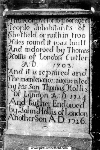
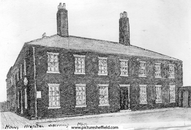
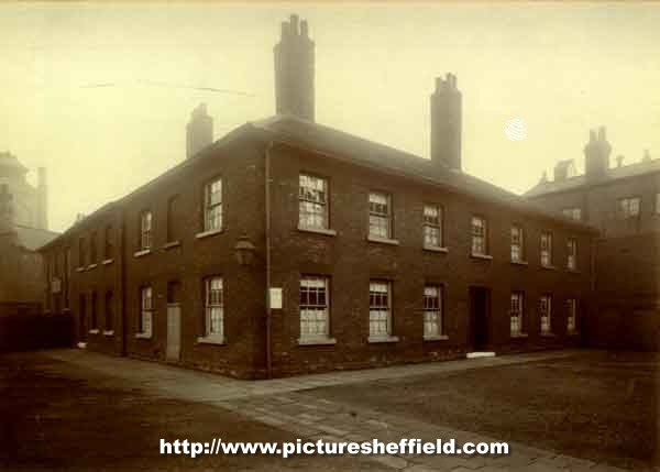
Hollis Hospital, left side fronting Bridge Street. y01867 Founded 1703 by Thomas Hollis, who purchased the first Dissenting meeting-house in Sheffield, called the New Hall and adjoining house and had it converted into 16 dwellings for poor women. Built 1776. Demolished 1901. Hollis Hospital, entrance on Newhall Street. 1900.arc02334 Photographer: Yates, Fargate. Original at Sheffield City Archives ref. MD7596/3. Hollis Hospital, inside the hospital premises; from a photograph taken across the yard. 1900.arc02335 Rear of Hollis Hospital and Schools, building on right fronts Bridge Street. Buildings on left fronts Court No. 1, Water Lane. u03278 A plan of Hollis's Hospital in Sheffield and several adjacent tenements which belong to the Trust. 1789. https://www.picturesheffield.com/frontend.php?keywords=Ref_No_increment;EQUALS;arc03803&pos=31&action=zoom&id=99474 This Plan shows position of Hollis Hospital on the extreme right. The Earl of Surrey's tenements between Bower Street and New Hall Street, [1781] https://www.picturesheffield.com/frontend.php?keywords=Ref_No_increment;EQUALS;arc04286&pos=34&action=zoom&id=105965 Shows: Bower Spring Lane, Spring Croft, Steelhouse Lane, Workhouse Lane, Hicks Lane, New Hall Street [Newhall Street], footway to Bridgehouses, Under the Water, Town Mill Wheel and Town Mill. John Hawksworth, Jno. Askwell / Ashwell, John Wainwright, Ann Genn, Joseph Frisket, Samuel Broadbent, W. Fowler, James Foulds, Thomas Fox, Widow Warrington, Samuel Matthews, Denis Belk, William Fox, John Deykin, wardens of a club, Ann Young’s heirs, George Greene, Joshua Wright, Samuel Bates, Matthew Fenton, George Greaves, Robert Dring, John Brownell, Thomas Holy’s heirs, William Booth, Ann Newton, Francis Sayles, heirs of Nicholas Hick, William Thompson, James Mellor, heirs of Samuel Smith, John Robinson, Samuel Hirst, Thomas Smith, Thomas Taylor, John Fox, Samuel Norris, John Vickers, Samuel Camm, Joseph Wildsmith, George and Philip Smilter, Mary Pashley, Joseph Ashforth, Hollis Hospital. Plaque from Hollis Hospital. y00590 Leighton in the conversation below obviously doesn't quote it word for word, but the gist of it. Edit: All is revealed in a later posts containing another Plaque and in the Hollis Hospital.org. History.... Leighton quoting from an earlier "modest but ancient building" near the Cathedral with a Plaque. Extract from articles and letters from The Sheffield and Rotherham Independent 1872/3, edited by Robert Eadon Leader 1875. "Reminiscences, it's Streets and its People." Page 111. "Leighton: Standing with its side to Newhall Street and facing Millsands is Hollis's Hospital, or, as it used commonly to be called, Brown Hospital, built on the site of the first Dissenters' Chapel in the town. Its history is to be found in Hunter's Hallamshire; but the inscription on the Newhall Street- side, over a blocked-up doorway, may be recorded here, for although there seems to be no present prospect of its obliteration, when such things do disappear there is no recovering them : — "This Hospital, for sixteen poor aged Inhabitants of Sheffield or within two Miles round it, And School for fifty children, were founded by Thomas Hollis, of London, Cutler, 1703, And further endowed by his sons,Thomas Hollis, 1724, and John Hollis, 1726, And rebuilt more commodiously by the Trustees,1776." Everard: While almost everything else round here has changed, this building remains the same, close to busy thoroughfares, and yet, as it were, removed from them. Stepping down here, only a few yards from the noisy streets, has to some extent the effect of getting into a Cathedral close." Pages 189 &190. St. Thomas's Day in Hollis Croft. "Leighton: An old Hollis Croft public-house was "The Cock." Wragg: Yes, it was once kept by the father of the Mr. Jonathan Beardshaw, who has been mentioned as landlord of the Ball, Hawley Croft. His widow and his daughter's husband, named Henderson, also kept it. Leighton: Passing down the street, a few days ago, I found myself standing opposite to the house. I was sorry to see that the Cock had lost some of the *** plumage which adorned him so well 40 or 50 years ago; yet he still holds up his crest as proud as ever, and is ready to do battle as in the days of yore against all who shall presume to poach upon his domestic domain. I thought of the days that are long gone by, and of the old song : — "Bright Chanticleer proclaims the dawn. And spangles deck the sky." Again, "My Lord, the early village cock hath thrice Bid salutation to the morn." And again, that it was St. Thomas's Day. All hail to the founders of the Hollis Hospital, from whom the Croft takes its name. They are to be found recorded within the grounds at the bottom of Snig Hill, and a full history is given in Hunter's Hallamshire. The Trustees in their wisdom, and no doubt with the best intentions, let the ground in Hollis Croft on building leases for 900 years, the front at Is. per yard, and large pieces of ground at the back for nothing. That they were generous souls is sufficiently proved by their allowing three guineas to the tenantry to enable them to enjoy a good old English dinner. It was held at the "Cock," on St. Thomas's Day, and these are the names of some of those who took a delight in attending. There were three brothers of the name of Shepherd, two of whom I knew. They were invariably together, one of them walking about a yard in advance of the other. Other two brothers were Samuel and Benjamin Marples. I had the pleasure of knowing them well — honesty and truth were in them, and when one died the other could not live; he did not long survive his friend, his companion, his brother. Now, whatever I have said in praise of the above applies equally to those I shall mention below — Mr. Philip Law, Mr. John Spencer (Matthias Spencer and Son, Pea Croft); and oh, what delight I feel when I meet his venerable figure, and look upon his cheerful countenance. He will long be remembered. Mr. Jonathan Beardshaw, of whom more anon; Mr. John Hawksley, Mr. James Wild (of whom you have heard before), Messrs. Shirtcliffe, Skinner, Barraclough (Messrs. Wingfield and Rowbotham), Benjamin Leathley, Thomas Makin, Charles Sanderson, and various others. Their descendants are still amongst us, keeping up the good names of their families. The dinner is over, the usual loyal toasts are given, the land-lord ordered; the spirits, the lemons, the sugar & etc, are brought in, and Mr, Beardshaw, in accordance with the time-honoured custom, is called to mix the punch. He consults his friends. A little more lemon, says Mr. Wild; a little more sugar, says another; and the mirth begins. Mr. Beardshaw is called upon to sing his song of the "Flat Backs": — " To mak 'em we are willin, A basket full for a shillin, Red herrins and potatoes Our bellies to be fillin." But though times were bad with them, they could still be generous with the ale, and "Pray the' gie Steen (Stephen) a sup, for he is varry dry, his throat is full of smithy sleek, the wind has been so high." Other songs followed. The old warlike ones were not forgotten. "Let the song go round, let the shouts resound, Let the trumpet sound on Spanish ground; Let the cvmbals bang, with a merry, merry clang, To the joys of the next campaign — To the joys of the next campaign." Amidst all the mirth and jollity which prevailed, one thing was never forgotten, a subscription for the poor widows of the street. It was always a liberal one, and I have no doubt carried comfort and consolation along with it. It is not always a pleasure to recall the past, but in the course of a pretty long life I have experienced a full share of bright sunshine, to which I can look back with pleasure; and some of the moments I passed on St. Thomas's Day, at the sign of the " Cock," are among these. Several of those whom I have named above could well afford to ride in their own carriages, but they were plain men, and would have felt ashamed to have been seen in them; but in these days, when wealth is accumulated by leaps and bounds. "Some drive along with four in hand. While others drive at random, In wisky-buggy, gig or dog-cart, Curricle or tandem." Twiss: When speaking of fraternal affection of Samuel and Benjamin Marples you might have added that, inseparable as they were, it was the rarest thing in the world to see them without their wives. The four were always together, and formed a most harmonious quartette." Plan of the property in Sheffield belonging to the Trustees of Hollis' Hospital let on building leases, 1855 (copied 1859) includes Hollis Croft. https://www.picturesheffield.com/frontend.php?keywords=Ref_No_increment;EQUALS;y09970&pos=27&action=zoom&id=65489 Ordnance Survey Map, sheet no. Yorkshire No. 294.7.15 1889 (Hollis Croft can be seen bottom right, The Cock P. H marked about halfway up). https://www.picturesheffield.com/frontend.php?keywords=Ref_No_increment;EQUALS;q00060&pos=63&action=zoom&id=106069 Hollis Croft Sheffield, Cock public house and mystery medieval coin. https://www.wessexarch.co.uk/news/hollis-croft-sheffield-cock-public-house-and-mystery-medieval-coin Hollis Hospital Trust, Sheffield. https://discovery.nationalarchives.gov.uk/details/c/F109998
-
Clarity Lack, "Lustre Silver" EP Trademark's Owner.
Kalfred replied to Kalfred's topic in Made In Sheffield
Thank you Boginspro and Ponytail for your suggestions and additions regarding Lustre Silver. Thomas H. Blake would be a candidate as he had by 1885 launched his business in Holly Lane as an electro-plate spoon and fork manufacturer, but I do not think the "THB" is Thomas H. Blake. I see "TH" as the "concern" and a "B" for electroplate grade quality. That quote for Frederick Green & Sons, as shown by the respected site "silvercollection.it" could fit but I can not find the Sheffield trade directory entries that back up that sites suggested dating. I checked Sheffield directories around the suggested last decade of the 19th century dates that I could see on line, but found no Frederick Green & Sons. There will be directories that are not on line of course that may have the positive evidence that proves the suggestion. I just think the "Lustre Silver" question needs more answers. Kalfred -
Morton Wheel, Philadelphia Works & Bacon Island (Isle) Morton Wheel is recorded in the earliest surviving Norfolk rentals in 1581, but let as north and south ends, which usually suggests 2 halves of one structure. Robert Hobson rented the south end for 20/- and Hugh Attwell the north. 1604, the tenants: Ellis Younge & Robert Shawe paying £4/20/- 1637 Harrison Survey: Thomas Wright, James and Robert Creswicke and William Walton renting 'one half of Morton Wheel' with Robert Sorsby, George Hobson and Edward Creswick the other half. List of Wheels 1641: The two Creswickes, Walton and Matthew Webster rented, 'one cutler wheel called Morton Wheel' for £ 7/10/- Sorsbie, Hobson and Edward Creswicke the same amount for 'the other Morton Wheel' suggesting there were two wheels; not until the middle of the c18th were two separate sites are identified. The Creswickes continued to lease until 1720s. Two groups of tenants took a 21year lease 1666. The Norfolk Estate woodward accounts records repairs in 1676 1716, Leases to cutlers and scissor smiths include Samuel Creswick. An inventory for George Greaves, scissor smith dated 1739 lists. 'goods, working tools, 4 grinding stones, 4 caulks valued at 15/-; 4 glazers; 9 pulleys, 2 horsings, 4 axle trees, a wheel band, a wheel kitt and trough value £2/10/- and 'the goodwill of one original grinding trow at Morton Wheel' £70. Another source; 1760 Rate Assessment reveals: the lease of 1738 instead of the tenant, the landlord paid Land Tax, Poor Rate & Highway Assessment. In 1759 Bradshaw, Overseer of the Poor wanted to double the rate, when the Norfolk Estate refused, he distrained goods at the wheels, the tenants of which then had grounds for 'action of trespass' as none of the 'goods' belonged to the Estate. The document listing the stones removed identifies 'first; second; third and Nether Wheel.' 1739 rentals, records 'New Wheel' which is probably refers to the now named Nether Wheel. 1789 Lease separates "Upper & Lower" Wheels. 1794 recorded separately, with 41 troughs at Upper and 16 at Lower, Samuel Smith working them both. 1800 Nether Hallam Rate Book, Smith recorded for the first time. Land of Samuel Ashton & Co. and George Sybray, at Morton Wheel, [Penistone Road] 1794. https://www.picturesheffield.com/frontend.php?keywords=Ref_No_increment;EQUALS;arc03682&pos=5&action=zoom&id=99253 Map of two parcels of ground near to the Morton Wheel. 1795. Ground between Penistone Road and the Morton Wheels Dam. Yardage and owners given. https://www.picturesheffield.com/frontend.php?keywords=Ref_No_increment;EQUALS;arc02714&pos=4&action=zoom&id=91681 1801 Smith, Hoole & Co., were working 87 troughs. 1807 Norfolk Estate sold the Wheels; over 30 years shares changed hands several times; by 1814 named Philadelphia Works, main partners being Parkin & Hounsfield after 1828 the Butchers; 1844 William & Samuel Butcher alone. 1850 and 1865 Rate Books record a steam corn mill and a tilt forge in part of the works;. indications that Water Power no longer used as no head and fall recorded. The other part, water power still available for the tilt forge and rolling mill. Water power still available 1874 & 1901, William Bury & Co. in occupation at the forge & rolling mill with engine house included with the head and fall still recorded. Little to be seen of the site apart from the Weir and shuttle into the former head-goit. Upper Dam was built over, no buildings remain. Tail-goit which also took water from the lower wheel also built over. Head goit of Nether Wheel not shown on 1892 OS map, nothing remains of the dam either. Buildings and overflow from the dam to the river shown up to 1843 maps have also disappeared. Information from: Water Power on the Sheffield Rivers, edited by David Crossley with Jean Cass, Neville Flavell & Colin Turner. Shown on this Plan of part of the townships of Sheffield and Nether Hallam which is in dispute. 1826. https://www.picturesheffield.com/frontend.php?keywords=Ref_No_increment;EQUALS;arc03896&pos=3&action=zoom&id=97354 The ground concerned includes Upperthorp [Upperthorpe], Port Mahon, Nether Thorp [Netherthorpe] and the land between White House Lane (Infirmary Road) and Morton Wheels. Includes John Addy's house, Lidgate Field, Shales Moor Close, White House Lane or Walkley Road, Penistone Turnpike Road, old road from Owlerton to Sheffield, Green Lane, Cleakham [Cleakham Inn], Morton Wheel and Morton Wheel Dam, River Dun and Bacon's Island, Waterworks, Poor House, Bellefield House, Daniel Hill, Infirmary, Philadelphia, West Dun, Barracks (old Cavalry), Bowling Green, a Tavern [possibly the Cambridge public house], St Philips Church, Globe Works, Roscoe Place, Hoyle Street, Dun Street, Moor Fields, Green Lane, etc. Ordnance Survey Map, sheet no. Yorkshire No. 294.3.25. 1889. Philadelphia Works bottom left. https://www.picturesheffield.com/frontend.php?keywords=Ref_No_increment;EQUALS;q00037&pos=8&action=zoom&id=103541
-
Toad Hole Cottages and Vestry House, Toad Hole Lane (now Southey Green Road), under demolition. u00487 For more details see 'It was all country then' by Sylvia Anginotti, p13-5. Toad Hole Cottages, 5th February 1937.u03089 u03090 Information with photographs: Position 5 (See Plan). Does this information relate to the book by Sylvia Anginotti? Toad Hole Cottages, Occupied the site of Ritz Bingo Hall, Wordsworth Avenue. Photograph shows Vestry House with spring water well by the wall.s11414 School Lane/Toad Hole Lane (now Southey Green Road) looking towards Toad Hole Cottages and Southey Green in the backgrounds00506 Information with the photograph. "Vestry House in the background" Toad Hole Cottages. s11631 Cottages Southey Green, Moonshine Line near the junction with Toad Hole Lane and Southey Lane. u00474 Information from Mick Armitage: Part of the old Southey Village and stood roughly where the current shops stand at the top end of Galsworthy Road just before it joins Moonshine Lane This property is refered to as Deerlands see Sylvia Anginotti's 'It was all country then' Ref: 942.74 SQ p16-18. The maps of the period are more likely for it to be Southey Village.

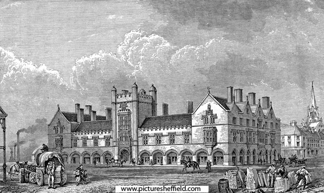
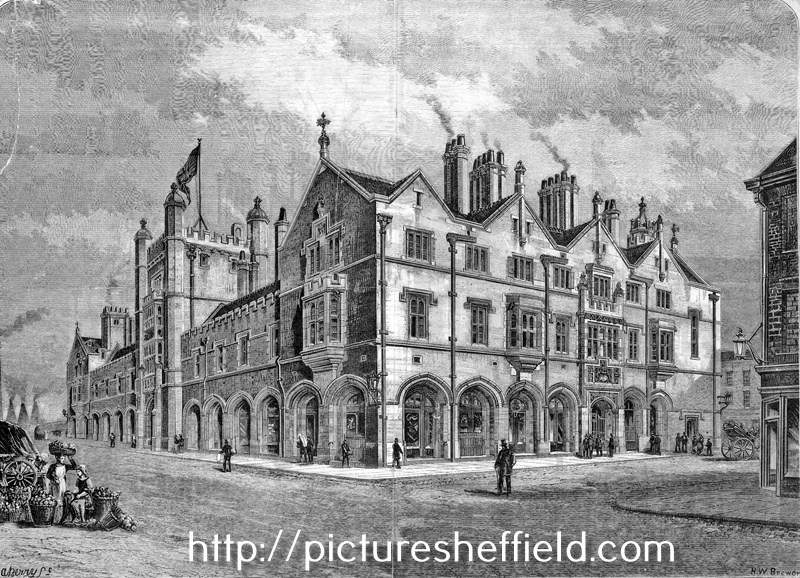
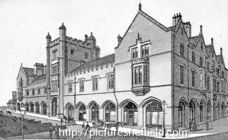
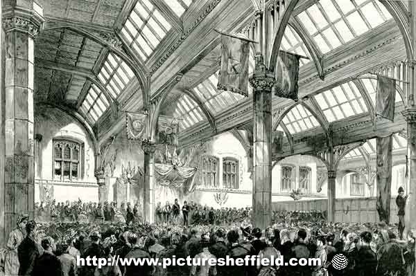
-
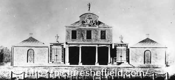
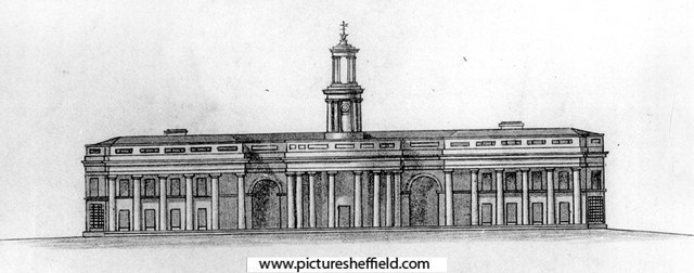
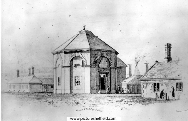
New Corn Exchange, built early 1880-81, Broad Street, right. s00292 Corn Exchange - built for the Duke of Norfolk in 1881 The Central Hall of the Corn Exchange was gutted by fire in 1947 and the offices surrounding it were demolished in 1964. Engraving of the newly built Corn Exchange, Broad Street, right. s22437 H.W. Brewer (Etcher) u02332 The Shah of Persia [Iran] in England - scene in the Corn Exchange, Sheffield, during the presentation of an address from the Mayor. 1889.y11829 Image from The Graphic, 20 July 1889. Sheffield Local Studies Library: MP 1834 L. Architects drawing for the Old Corn Exchange, Broad Street erected 1830. This design was never built. s41155 Architects design for the old Corn Exchange - 1830 (this was not the adopted design) s01896 The old Shrewsbury Hospital, Castlefolds, founded 1616. The Corn Exchange later stood on this site. 1st January 1819.s07452 E. Blore, Artist Plan of part of the town of Sheffield, comprising the site of the present and proposed corn, hay and cattle markets, also various improvements connected with the latter. 1827. With illustrations of proposed Corn Exchange, elevation of the houses fronting the new Hay Market, and an elevation of the bridge over the Dun [Don]. https://www.picturesheffield.com/frontend.php?keywords=Ref_No_increment;EQUALS;arc04183&pos=14&action=zoom&id=104936 Reference a - Proposed Corn Exchange and office, b - erections on each side of Corn Exchange, c - weighing machine, d - row of shops. Inns in the immediate vicinity of the present Hay and Corn Markets 1 George, 2 King’s Head, 3 Angel, 4 Commercial, 5 Yellow Lion, 6 Tontine, 7 Healeys Hotel. The sites of the present Hay, Corn and Cattle markets are coloured red, and proposed are coloured blue. Other improvements are shown in yellow. Marked are: Market Place, Angel Street, Angel Inn, old Corn Market, King Street, Post Office, Change Alley, Kings Head, Fruit Market, Market Street, Norfolk Street, John Street, Commercial Inn, Hay Market, Yellow Lion, Pond Lane, Shude Hill, Fish Market, Dixon Lane, Tontine Inn, Castle Folds, Castle Hill, Healeys Hotel, Sheaf Bridge, River Sheaf, canal bridge, proposed Hay Market, proposed Corn Market, Broad Street, Canal Basin, Canal Warehouse, Market for fat cattle, lean cattle and milch cows, pig market, sheep market, River Dun [River Don], Willey Street, Blonk Street, Wicker, Cattle Market, Ladys Bridge, Bridge Street, Wain Gate, Town Hall, Killing Shambles and Castle Street. Sheffield Markets. 1847. https://www.picturesheffield.com/frontend.php?keywords=Ref_No_increment;EQUALS;arc04188&pos=16&action=zoom&id=104947 Marked: Old Haymarket, Dixon Lane, Castle Folds, Exchange Street, new market ground, Cheese Market, Corn Exchange, Broad Street. New Corn Exchange - plan showing groups of desks. 28th November 1881. Architects: M E Hadfield and Son, Architects, New Corn Exchange Chambers. https://www.picturesheffield.com/frontend.php?keywords=Ref_No_increment;EQUALS;arc04419&pos=8&action=zoom&id=151747 Corn Exchange - office doors, panels and rails, etc., c.1881? Not dated. https://www.picturesheffield.com/frontend.php?keywords=Ref_No_increment;EQUALS;arc04417&pos=6&action=zoom&id=151745 Corn Exchange - doorway, etc., c.1881? Not dated. https://www.picturesheffield.com/frontend.php?keywords=Ref_No_increment;EQUALS;arc04418&pos=7&action=zoom&id=151746 Maunche Hotel and Corn Exchange, Exchange Place / Wharf Street on Ordnance Survey Map. 1890. https://www.picturesheffield.com/frontend.php?keywords=Ref_No_increment;EQUALS;y06787&pos=3&action=zoom&id=59989
-
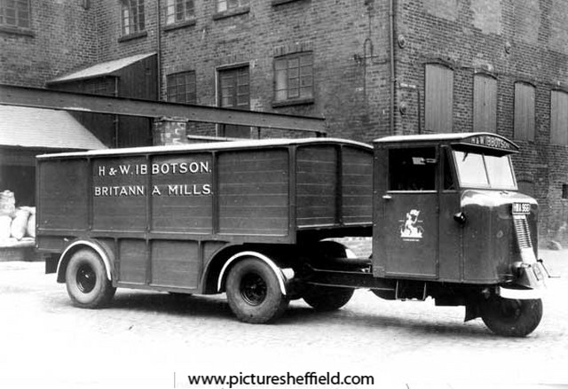
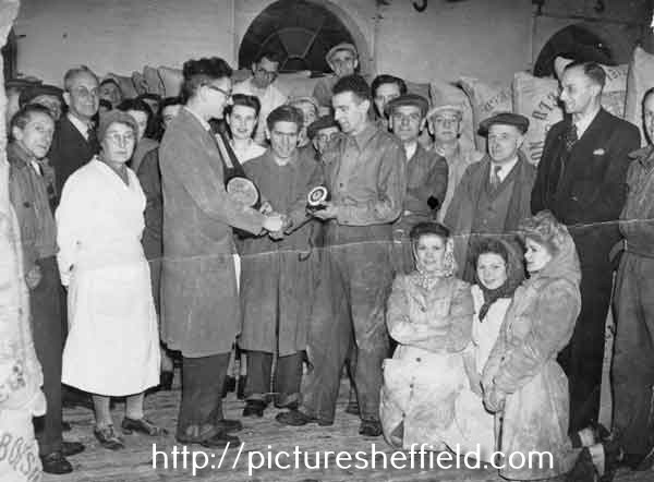
Britannia Mills 1879, 1901 & 1905 White's Directories H & W, Ibbotson, corn millers & corn merchants, Britannia Corn Mills, Alma Street & No. 19 (1901) 44 (1905) Corn Exchange. 1879, Henry and William Ibbotson living at Somerset Villa, 57 Burngreave Road. 1901, Henry and William Ibbotson, corn millers living at Shirecliffe House, 108 Shirecliffe Lane. 1905, Charles; Henry D; William, corn millers & Susan Ann Ibbotson living Shirecliffe House, 108 Shirecliffe Lane. Morning Telegraph Obituary Index. Henry Ibbotson of Britannia Corn Mills 27th December 1903 Henry Davis Ibbotson of H & W Ibbotson, Britannia Flour Mills 29th November 1930. H. and W. Ibbotson, Britannia Mills, corn millers, Alma Street, Kelham Island. t03724 Lorry belonging to H and W Ibbotson, corn millers of Alma Street, Kelham Island. t07661 Photograph from records of the Hallamshire Tyre and Motor Company at Sheffield Archives. Registration no. HWA 996. Presentation to the foreman, Mr. Johns who was leaving to take up a position at another mill. Part of caption on reverse reads: 'all office and work people together'. u10814 Extreme back (in arch with cap on) Aaron Rianowski? (original is difficult to decipher) Ibbotson's Boundary Line Plaque, Kelham Island, September 1978. w01425 Photographer David Cathels.
.jpg.6d51ac02997701b3a8ae404e39d22051.jpg)
-
Plan of the premises in Arundel Street and Sycamore Street belonging to Parker, Potts and Denton, and of the adjoining premises belonging to James Hibberson, 1827. https://www.picturesheffield.com/frontend.php?keywords=Ref_No_increment;EQUALS;arc04033&pos=1&action=zoom&id=103278 Shows Arundel Street, [Arundel Lane], Sycamore Street, foot road from Pond Street, John Wilson's furnaces, stable, carriers warehouse, counting house, brewhouse, gateway, house, passage, Balloon Tavern, workshops, merchant's warehouse, etc. Note a trade directory of 1829 lists Parker, Potts and Denton as Edge Tool Manufacturers of Arundel Street; and - Hibberson, as a carrier (with carriages to Hull, Liverpool, Manchester and Cheshire) Land sold by Parker, Potts and Denton to their neighbour, James Hibberson. No date. https://www.picturesheffield.com/frontend.php?keywords=Ref_No_increment;EQUALS;arc04034&pos=2&action=zoom&id=103279 Shows Arundel Street, Arundel Lane, Sycamore Street, and Parker, Potts and Denton's premises, comprising cart house (hay loft), stable and workshops. Also shows James Hibberson's new stables. Plan of the freehold premises in [Arundel] Street and Sycamore Street belonging to Parker, Potts and Denton. 1828 https://www.picturesheffield.com/frontend.php?keywords=Ref_No_increment;EQUALS;arc04035&pos=3&action=zoom&id=103280 Shows: Arundel Street, Arundel Lane, Sycamore Street, and Parker, Potts and Denton's premises, comprising cart house (hay loft), stable and workshops. Also shows James Hibberson's property, together with a theatre further up Sycamore Street (at junction with Arundel Street) [?Theatre Royal].
-

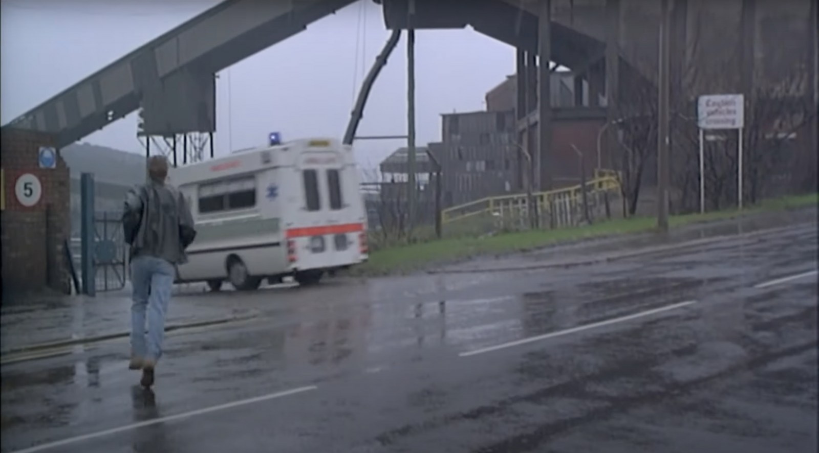
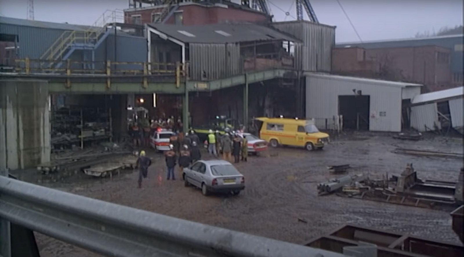
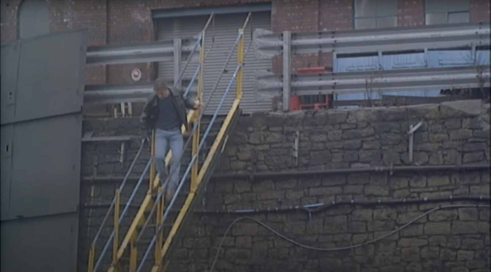
Tragedy at the pit scene - When Saturday Comes Filming Location
Sheffield History posted a topic in When Saturday Comes
A few shots from the pit scene but I've no idea where this one is - can you help? Do you recognise this pit? If so post below and let me know! 👇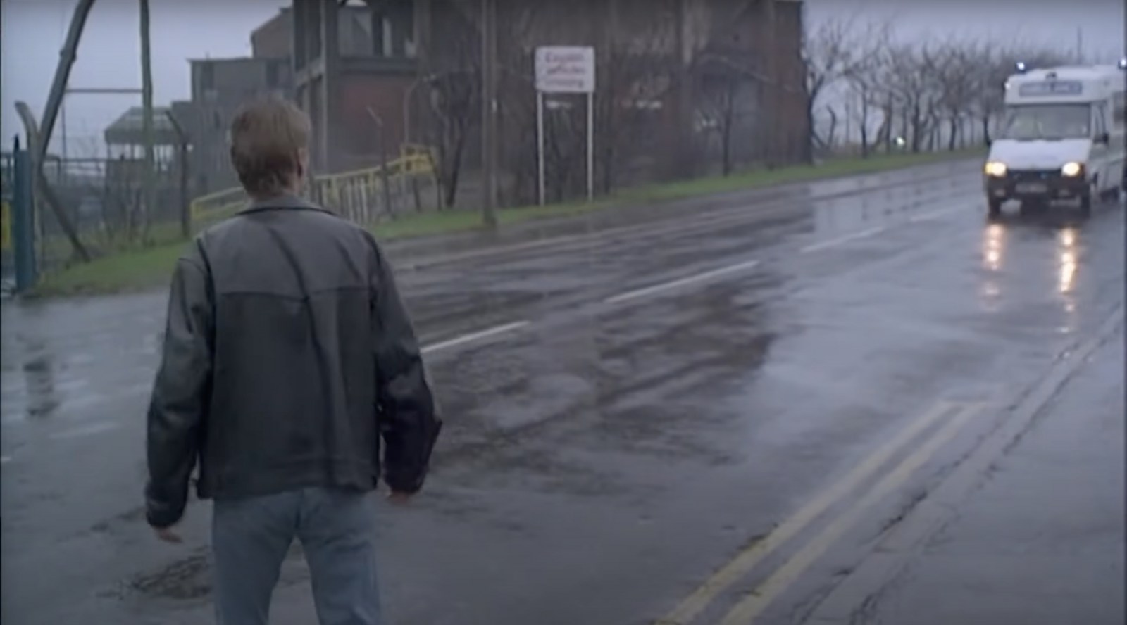
-
Is this the same sort of thing as previous post or are they just measuring the road out? Section of land near Broad Lane. Not dated. https://www.picturesheffield.com/frontend.php?keywords=Ref_No_increment;EQUALS;arc04051&pos=128&action=zoom&id=57011 St George’s Square. Section near Broad Lane, for St George’s Church, 1806. https://www.picturesheffield.com/frontend.php?keywords=Ref_No_increment;EQUALS;arc04054&pos=129&action=zoom&id=61724 St George’s Square. Section across the lower street in Broad Lane for St George’s Churchyard, 1806. https://www.picturesheffield.com/frontend.php?keywords=Ref_No_increment;EQUALS;arc04053&pos=130&action=zoom&id=62214
-
The Ringinglow estate, the property of the late Thomas Rawson, 1827] https://www.picturesheffield.com/frontend.php?keywords=Ref_No_increment;EQUALS;arc03946&pos=44&action=zoom&id=101954 Git Mottram: 1. Rough Smeltings and Croft, 2. House and garden, 3. Upper Smeltings, 4. Lower Smeltings. In hand, 5. New planting, 6. Bank plantation, 7 and 8. plantations, 9. Weigh house, 10. Rough plantation toll house and part cultivated, 11. Stack Garth Plantation, 12 - 14. Plantations, 15. Upper Lumb, 16. Lower Lumb, 17. Plantation adjoining Porter Brook. 18. plantation in Angram Lane. Richard Whitworth 19. Ringinglow Inn [later the Norfolk Arms], homestead, out buildings, yard and garden, 20. Stack Garth, 21. House Field, 22. Upper Planting field, 23. Cow Pasture, 24. Lamb Field, 25. Low Rye Field, 26. Rye Field. 27. Horse Pasture, 28. The Rough Banks; James Creswick, 29. Bottoms, 30. Well Bank, 31. Well Field, 32. Middle Common Piece, 33. Four Acre, 34. Barley Field, 35. Wiggin Field, 36. Bennet Field and Calf Croft, 37. Anise Field, 38. Planting Field, 39. Croft, 40. Homestead, house etc., 41. Old Field; Benjamin Fox, 42. Bank., 43. [black], 44. Broomhead Field, 45. Pingle. Thomas Watson, 46. Allotment. Also shows colliery, road from Grindleford Bridge [Sheephill Lane], Ringinglow Road, Barber Fields, road to Fulwood [Fulwood Lane], site of [Norfolk Arms], [toll house], house field, Angram Lane, road to Birks Green and road from Bower Hill [Cottage Lane?].
-
My granddad Robert sustained a broken spine as a result of being crushed between a full tub of coal and the pit side of Nunnerley colliery on 14 May 1947. He died in the Sheffield Royal Infirmary on the 16th. The coroner for the City of Sheffield raised an inquest on the 17th. Would anyone know if I can see a copy of this? Also, would grandma have received any compensation? Many thanks, Derek.
-
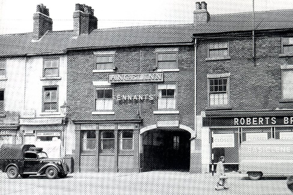
Built in the 1820s, shortly after demolished to make way for the rather ugly Charter Square; wall mounted gas lamp, no entrance at all to the pub !!! "Hey Bert, how do we get into this boozer ?" "Down the alley at the side you idiot !" Roberts Brothers store (awaiting the move to their new place on the Moor)
-
Digging for coal during the National Coal Strike, showing crowd at Candle Main, Silkstone Seam, possibly High Hazels Park https://www.picturesheffield.com/p01580 https://www.picturesheffield.com/p01579 "Silkstone Seam, High Hazels during the coal strike" https://www.picturesheffield.com/v02564 "Outcrop workers at Fenderbelly Main Pit during Coal Strike" https://www.picturesheffield.com/s03755 "Hauling outcrop coal during Coal Strike" https://www.picturesheffield.com/s03753 "Coal gatherers on Nunnery tip during Coal Strike" https://www.picturesheffield.com/s03728 "Outcrop mining in Manor Lane during Coal Strike" https://www.picturesheffield.com/s03726 "Helping the Needy during the Coal Strike" https://www.picturesheffield.com/s03723 "Poor waiting for coke at Grimesthorpe Gasworks during Coal Strike" https://www.picturesheffield.com/s03720
-

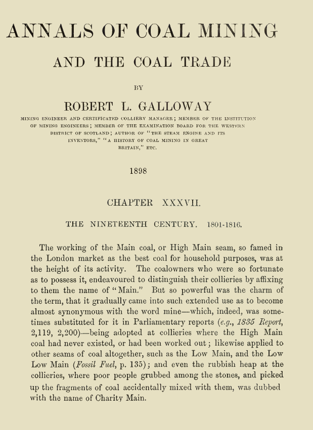
What does "main" mean in a colliery name ?
Edmund replied to JS2021's topic in Sheffield History Chat
It appears that the tradition of naming collieries as "Main" originated in the North East at an early date. The "Main" seam coal was so attractive that even collieries that did not extract coal from the Main seam began to use the name, and "Main" became synonymous with Mine" :