Search the Community
Showing results for 'coal pit lane'.
-
Morton Wheel, Philadelphia Works & Bacon Island (Isle) Morton Wheel is recorded in the earliest surviving Norfolk rentals in 1581, but let as north and south ends, which usually suggests 2 halves of one structure. Robert Hobson rented the south end for 20/- and Hugh Attwell the north. 1604, the tenants: Ellis Younge & Robert Shawe paying £4/20/- 1637 Harrison Survey: Thomas Wright, James and Robert Creswicke and William Walton renting 'one half of Morton Wheel' with Robert Sorsby, George Hobson and Edward Creswick the other half. List of Wheels 1641: The two Creswickes, Walton and Matthew Webster rented, 'one cutler wheel called Morton Wheel' for £ 7/10/- Sorsbie, Hobson and Edward Creswicke the same amount for 'the other Morton Wheel' suggesting there were two wheels; not until the middle of the c18th were two separate sites are identified. The Creswickes continued to lease until 1720s. Two groups of tenants took a 21year lease 1666. The Norfolk Estate woodward accounts records repairs in 1676 1716, Leases to cutlers and scissor smiths include Samuel Creswick. An inventory for George Greaves, scissor smith dated 1739 lists. 'goods, working tools, 4 grinding stones, 4 caulks valued at 15/-; 4 glazers; 9 pulleys, 2 horsings, 4 axle trees, a wheel band, a wheel kitt and trough value £2/10/- and 'the goodwill of one original grinding trow at Morton Wheel' £70. Another source; 1760 Rate Assessment reveals: the lease of 1738 instead of the tenant, the landlord paid Land Tax, Poor Rate & Highway Assessment. In 1759 Bradshaw, Overseer of the Poor wanted to double the rate, when the Norfolk Estate refused, he distrained goods at the wheels, the tenants of which then had grounds for 'action of trespass' as none of the 'goods' belonged to the Estate. The document listing the stones removed identifies 'first; second; third and Nether Wheel.' 1739 rentals, records 'New Wheel' which is probably refers to the now named Nether Wheel. 1789 Lease separates "Upper & Lower" Wheels. 1794 recorded separately, with 41 troughs at Upper and 16 at Lower, Samuel Smith working them both. 1800 Nether Hallam Rate Book, Smith recorded for the first time. Land of Samuel Ashton & Co. and George Sybray, at Morton Wheel, [Penistone Road] 1794. https://www.picturesheffield.com/frontend.php?keywords=Ref_No_increment;EQUALS;arc03682&pos=5&action=zoom&id=99253 Map of two parcels of ground near to the Morton Wheel. 1795. Ground between Penistone Road and the Morton Wheels Dam. Yardage and owners given. https://www.picturesheffield.com/frontend.php?keywords=Ref_No_increment;EQUALS;arc02714&pos=4&action=zoom&id=91681 1801 Smith, Hoole & Co., were working 87 troughs. 1807 Norfolk Estate sold the Wheels; over 30 years shares changed hands several times; by 1814 named Philadelphia Works, main partners being Parkin & Hounsfield after 1828 the Butchers; 1844 William & Samuel Butcher alone. 1850 and 1865 Rate Books record a steam corn mill and a tilt forge in part of the works;. indications that Water Power no longer used as no head and fall recorded. The other part, water power still available for the tilt forge and rolling mill. Water power still available 1874 & 1901, William Bury & Co. in occupation at the forge & rolling mill with engine house included with the head and fall still recorded. Little to be seen of the site apart from the Weir and shuttle into the former head-goit. Upper Dam was built over, no buildings remain. Tail-goit which also took water from the lower wheel also built over. Head goit of Nether Wheel not shown on 1892 OS map, nothing remains of the dam either. Buildings and overflow from the dam to the river shown up to 1843 maps have also disappeared. Information from: Water Power on the Sheffield Rivers, edited by David Crossley with Jean Cass, Neville Flavell & Colin Turner. Shown on this Plan of part of the townships of Sheffield and Nether Hallam which is in dispute. 1826. https://www.picturesheffield.com/frontend.php?keywords=Ref_No_increment;EQUALS;arc03896&pos=3&action=zoom&id=97354 The ground concerned includes Upperthorp [Upperthorpe], Port Mahon, Nether Thorp [Netherthorpe] and the land between White House Lane (Infirmary Road) and Morton Wheels. Includes John Addy's house, Lidgate Field, Shales Moor Close, White House Lane or Walkley Road, Penistone Turnpike Road, old road from Owlerton to Sheffield, Green Lane, Cleakham [Cleakham Inn], Morton Wheel and Morton Wheel Dam, River Dun and Bacon's Island, Waterworks, Poor House, Bellefield House, Daniel Hill, Infirmary, Philadelphia, West Dun, Barracks (old Cavalry), Bowling Green, a Tavern [possibly the Cambridge public house], St Philips Church, Globe Works, Roscoe Place, Hoyle Street, Dun Street, Moor Fields, Green Lane, etc. Ordnance Survey Map, sheet no. Yorkshire No. 294.3.25. 1889. Philadelphia Works bottom left. https://www.picturesheffield.com/frontend.php?keywords=Ref_No_increment;EQUALS;q00037&pos=8&action=zoom&id=103541
-
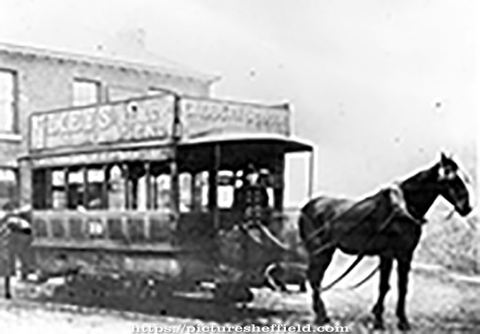
Boginspro, no doubt you will have seen this photograph. One Horse Tramcar, Single Deck No. 19. Tram for the Lady's Bridge, Saville Street and Brightside, outside the Bridge Inn, Brightside Lane. Car built by Starbuck of Birkenhead in 1874, withdrawn by 1901. s16296 Now in Corporation ownership note the word Company has been deleted. This picture was taken on or after 21st November 1896 the day that the Corporation took over the operation of the tramway service.
-
Further to the Flood Claim of the properties including naming The Steam Clock and the post for Brightside Lane Houses. The Steam Clock: Searched the Flood Archive with "Brightside Lane" Publicans: James Ellis, publican and farmer, Brightside Lane. https://sheffieldfloodclaimsarchive.shu.ac.uk/claimSummary.cfm?claim=3-2659 Thought James Ellis was a possibility until: James Ellis, Farmer & Publican, Midland Hotel, Brightside Lane, Sheffield Injured person: Mrs James Ellis, Landlady, Midland Hotel. https://sheffieldfloodclaimsarchive.shu.ac.uk/claimSummary.cfm?claim=9b-52 If the Building Society didn't own The Steam Clock then this could be The Steam Clock. Robert Laing, publican Record states he is the absolute owner. https://sheffieldfloodclaimsarchive.shu.ac.uk/claimSummary.cfm?claim=5-4517 There are however 14 properties whose address is "Lowe's Buildings" Brightside Lane. The claim on behalf of the Trustees of the Building Society care of Alfred Allott, Prior Court. lists 10 Houses plus 2 houses and shops adjoining a public house known as The Steam Clock. Possibility these are the ones but need to find who was "Lowe". Question still remains: Which one was The Steam Clock? Robert Bailey, Hay and Straw Dealer, of Lowe's Buildings, Brightside Lane. Absolute owner. https://sheffieldfloodclaimsarchive.shu.ac.uk/claimSummary.cfm?claim=4-3928 George Hall, collier. For personal property. https://sheffieldfloodclaimsarchive.shu.ac.uk/claimSummary.cfm?claim=6-5278 Edward Garner, brick layer. For personal property. https://sheffieldfloodclaimsarchive.shu.ac.uk/claimSummary.cfm?claim=6-5280 John Whiteley, labourer. For personal property. https://sheffieldfloodclaimsarchive.shu.ac.uk/claimSummary.cfm?claim=6-5286 John Ward, labourer. For personal property. https://sheffieldfloodclaimsarchive.shu.ac.uk/claimSummary.cfm?claim=6-5287 John Wright, brick maker. For personal property. https://sheffieldfloodclaimsarchive.shu.ac.uk/claimSummary.cfm?claim=6-5553 Aaron Ashmore, hammer drawer. For personal property. https://sheffieldfloodclaimsarchive.shu.ac.uk/claimSummary.cfm?claim=6-5554 John Hammond, brick maker. For personal property. https://sheffieldfloodclaimsarchive.shu.ac.uk/claimSummary.cfm?claim=6-5575 George Wraythby, brick maker. For personal property. https://sheffieldfloodclaimsarchive.shu.ac.uk/claimSummary.cfm?claim=6-5582 Abraham Cutts, labourer. For personal property. https://sheffieldfloodclaimsarchive.shu.ac.uk/claimSummary.cfm?claim=7-5588 Charles Jackson, shop keeper and milk dealer. For personal property. https://sheffieldfloodclaimsarchive.shu.ac.uk/claimSummary.cfm?claim=7-5589 Thorpe Bailey, labourer. For personal property. https://sheffieldfloodclaimsarchive.shu.ac.uk/claimSummary.cfm?claim=7-6229 Richard Shepherd, carpenter. For personal property. https://sheffieldfloodclaimsarchive.shu.ac.uk/claimSummary.cfm?claim=8-6299 Thomas Askworth, brick maker. For personal property. https://sheffieldfloodclaimsarchive.shu.ac.uk/claimSummary.cfm?claim=8-6317
-
Link to: Brightside Lane Houses. https://www.sheffieldhistory.co.uk/forums/topic/18229-brightside-lane-houses/
-
The Steam Clock public house, Brightside Lane. Sheffield Flood Claim: William Butcher, William Fisher and Thomas Edward Mycock, Trustees of the Sheffield & South Yorkshire Permanent Building and Investment Society, Care of Alfred Allott, Prior Court, Sheffield. For damage to 10 Houses & 2 Houses & Shops situate adjoining a Public House known as "The Steam Clock" in Brightside Lane, nr. Sheffield. https://sheffieldfloodclaimsarchive.shu.ac.uk/claimSummary.cfm?claim=7-5680
-
Map showing the position of the Cleakam (Cleakham) Inn, above Green Lane near to Morton Wheel. Not to be confused with Cleakum Inn at Malin Bridge. Plan of lands in dispute between the townships of Sheffield and Nether Hallam describing them as they were in the year 1783 according to a survey thereof made by the late William Fairbank of Sheffield. Dated 1826. https://www.picturesheffield.com/frontend.php?keywords=Ref_No_increment;EQUALS;arc03895&pos=2&action=zoom&id=97344 The ground concerned includes Upperthorp [Upperthorpe], Port Mahon, Nether Thorp [Netherthorpe] and the land between White House Lane (Infirmary Road) and Morton Wheels. Includes John Addy's house, Lidgate Field, Shales Moor Close, White House Lane or Walkley Road, Penistone Turnpike Road, old road from Owlerton to Sheffield, Green lane, Cleakam Inn, Morton Wheel and Morton Wheel Dam, River Dun and Bacon's Island etc. Cornish Street was previously known as Cleakham Wheel Road. A plan of the building lot in Cleakham Wheel Road [Cornish Street] taken of Thomas Shepherd by Henry Ibbotson. 1823. https://www.picturesheffield.com/frontend.php?keywords=Ref_No_increment;EQUALS;arc04196&pos=6&action=zoom&id=105072 Globe Works shown. Sheffield History A-Z Public Houses List: Cleakham Inn, Cornish Place. Open 1800 Closed Span Comments: open circa 1800; 1822 Cleakem Inn, Green Lane 1822 Amelia Facey/Faser/Fraser 1825 Thomas Hobley According to Michael Liversidge in his book "The definitive A-Z listing of Sheffield Public Houses. "...the only known fact was that the landlord was the owner of a bowling green, which was attached to the Cleakham. A Thomas Hobley or Thomas Copley was the landlord in 1839."
-
This also shows "Foresters" (left) don't know whether it something I'm doing/not doing, unable to get the Zoom to work to enable text legible. Possibly reads John Green. Plan of Messrs Brownell's freehold property in and near Carver Street, Sheffield. 1845. https://www.picturesheffield.com/frontend.php?keywords=Ref_No_increment;EQUALS;arc04077&pos=8&action=zoom&id=98738 By J. Fairbank and Son. Endorsed: This plan is drawn from an old survey. Shows Rockingham Street, West Street, Carver Street, Rockingham Lane, and Division Street. Tenants / owners: John Green, Samuel Laycock’s executors, Society of Methodists [Carver Street Wesleyan Chapel], John Moulson, Joseph Moulson, William Moulson, Edwin Moulson, Henry Duke, Francis Carr, Fenton and Shore, Bush and Broomhead and Nadin, Charles Brown, and Sorby and Sons.
-
The lot which became "Foresters" is shown at the junction of Division Street and Rockingham Street labelled boldly in capital letters as William Smith then underneath written "now John Green" Plan of certain building land the property of Messrs Brittain, Wilkinson and Brownell. 1829. https://www.picturesheffield.com/frontend.php?keywords=Ref_No_increment;EQUALS;arc04097&pos=14&action=zoom&id=103534 Shows Rockingham Street, Division Street, Rockingham Lane and Carver Street. Also, owners or tenants: John Harrop, Henry Blackwell; Charles Brown; William Smith; Jacob Bridge; John, Joseph, William and Edwin Mouslon. Steel furnaces, cutlers shops and warehouse marked. Surveyed and drawn by J. Fairbank and Son. Premise of William Smith also marked Jacob Bridge Plan of vacant land, the property of Verdon Brittain, Robert Robinson Brownell and Charles Brownell. 1829. https://www.picturesheffield.com/frontend.php?keywords=Ref_No_increment;EQUALS;arc04096&pos=13&action=zoom&id=103533 Shows Rockingham Street, Division Street, Rockingham Lane and Carver Street. Property leased to John Harrop, property leased to Henry Blackwell; also, owners or tenants: Charles Brown; William Smith; Jacob Bridge; John, Joseph, William and Edwin Mouslon. Forester's Inn marked right hand side towards the top. Ordnance Survey Map, sheet no. Yorkshire No. 294.7.25. 1889 https://www.picturesheffield.com/frontend.php?keywords=Ref_No_increment;EQUALS;q00075&pos=2&action=zoom&id=107161 Sheffield History A-Z Public Houses List. Forester's Inn/Yorick/The Yorl/Olive Bar, 57 Division Street Open 1828. 1828 William Smith 1833 William Smith 1834 William Smith 1837 Jacob Bridge 1839 W Deakin 1841 John Parsons [Pigot's ] 149 Rockingham Street 1841 William Richmond [ Whites ] 1845 Charles Holland (149 Rockingham Street) 1846 Charles Holland 1849 George Skinner 1852 George Skinner [57 Division Street] 1854 George Skinner 1856 George Skinner 1859 Herbert Rowe 1862 John Storey 1863 John Storey 1864 John Storey [57 Division Street] 1865 John Storey 1868 Thomas Webster 1871 Thomas Webster 1876 Thomas Webster [73-5 Division Street] 1879 William Thompson 1881 William Thompson [73 Division St] 1883 John Maxfield 1887 to 1890 John Maxfield 1893 John Maxfield 1895/6 Herbert Bevington 1898 Herbert Bevington 1900 to 1902 Herbert Bevington 1903 William Charles Lockwood 1905 William Charles Lockwood 1907 Mrs Eliza Smith 1910 to 1913 Frank Shelton 1916 Frank Shelton 1917 Frank Shelton 1919/20 Frank Shelton 1921 Herbert Walker 1922 Herbert Walker 1923 Sidney Hudson 1924 Gorden Lyall 1925 Gordon Lyall 1929 Gorden Lyall 1931 Harry Rose 1932 Mrs Sarah Agnes A Thomas 1933 Mrs Sarah Agnes A Thomas 1936 to 1939 Frank Jones 1942 Frank Jones 1944 Frank Jones 1948 Frank Lee (73-75 Division Street)
-
Cross Inn, Woodfall Lane, Low Bradfield, closed about 1980. https://www.picturesheffield.com/frontend.php?keywords=Ref_No_increment;EQUALS;s29646&pos=92&action=zoom&id=56159 Cottages at Low Bradfield which were originally the Cross Inn, Woodfall Lane. 4th September 1986.s29621 Low Bradfield. Cottages in the centre were orginally the Cross Inn. 4th September 1986. s29631
-
Plan of Joseph Fenton and William Butcher's premises in Pinstone Lane and Norfolk Street, 1847. 'Doe dem: Fenton versus Butcher. Plaintiff's plan' https://www.picturesheffield.com/frontend.php?keywords=Ref_No_increment;EQUALS;arc04177&pos=115&action=zoom&id=104518 Shows: Pinstone Lane, Norfolk Street, Union Street, Charles Street and Cross Burgess Street. Shows houses, kitchen, workshops, brewhouse, and Crown Public House. Also marked is the site of premises formerly of George Fisher. Also: Plan of Joseph Fenton and William Butcher's premises in Pinstone Lane and Norfolk Street. 1847. https://www.picturesheffield.com/frontend.php?keywords=Ref_No_increment;EQUALS;arc04176&pos=23&action=zoom&id=104517 'Plotted from dimensions along with Charles Unwin in order to test the accuracy of the plan made for the sale of Birks's premises in 1826, so that we might be able to give evidence thereon at the trial of the action of ejectment Doe dem: Fenton versus Butcher.' Shows Pinstone Lane and Norfolk Street. Marked are premises of Joseph Fenton (including brewhouse, privies and new shop) and premises of William Butcher. This plan arc04176 is the same area and names as plan arc04177 only Brewhouse marked but probably named Crown Public House. From Sheffield History A-Z Public Houses List: Crown Inn/Old Crown, 21 Pinstone Street. Open 1796; Closed 1898; Span 102 Comments: 1822 10, Pinstone Street Earlier 1818 (Pigots) William Hutchinson [Pinstone Lane] 1822 William Hutchinson 1825 William Hutchinson 1830 William Hutchinson 1833 William Hutchinson [ 11 Pinstone Street ] 1834 Joseph Outram 1837 Joseph Outram 1839 S Heath [ 21 Pinstone Street ] 1841 Samuel Heath 1846 George Fitzpatrick 1849 J Smith 1851 Thomas Puyer (census) (Ancestry entry corrected from Payer) 1852 Thomas Puyer 1854 Thomas Puyer 1856 Thomas Puyer 1859 Thomas Puyer 1862 to 1865 Sarah Allen (Old Crown) 1868 Sarah Allen 1871 Mrs Allen 1876 Sarah Allen [ 21 Pinstone Street ] 1879 Sarah Allen 1881 Edwin Allen A-Z also records 1881 & 1851 Census: 1881 Census: Edwin Allen aged 38, Publican born Sheffield. 1851 Census: Link broken. Can anybody find any more information about: Crown/Crown Inn/Old Crown, Pinstone Lane/Street.
-
Link to: Neepsend Tavern 144 Neepsend Lane. https://www.sheffieldhistory.co.uk/forums/topic/17961-neepsend-tavern-144-neepsend-lane/
-
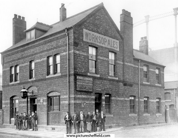
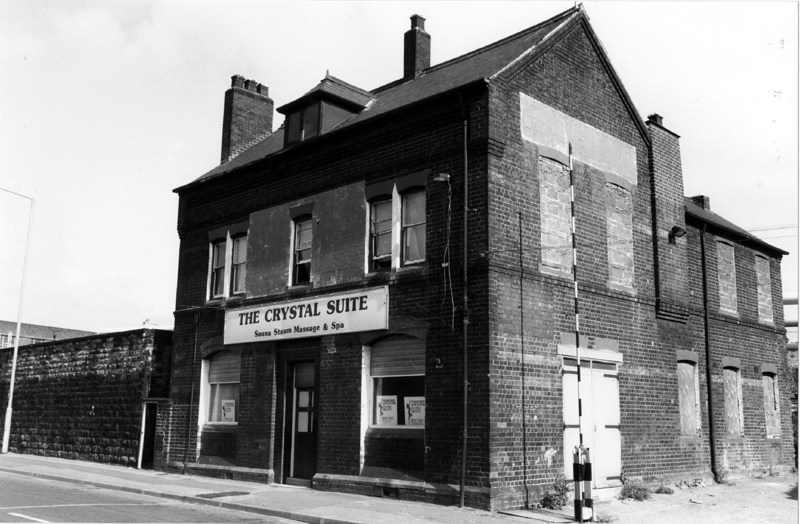
Neepsend Tavern, 144 Neepsend Lane. Worksop Ales, Fred Longden licensee. s06928 On the night of the Sheffield Flood, 11th & 22th March 1864, the Neepsend Tavern and many properties in the area were badly damaged. Extract from the "A Complete History of the Great Flood at Sheffield" "The Neepsend Tavern was partially submerged, and all the houses in Neepsend Lane were flooded to a great height. The boundary walls of the river were carried away, and many of the houses were gutted. Neepsend Bridge, built strongly of stone, sustained the shock of the Flood without giving way, but it was much shaken, and a part of the parapets of the bridge were thrown down. The stones were of immense size, and the force by which they were overturned must have been prodigious. A vast quantity of debris, timber, and furniture, was piled up against the bridge, which has formed a barrier to its further progress." The gardens (with statues and a large flagpole) and stables at the Neepsend Tavern were totally destroyed. The property including a Dram Shop, Tap Room, Bar, Brewhouse, Kitchen, Bedrooms & Cellars were badly damaged. The tenant and occupier Mary Dyson a widow, had only recently taken over the licence. (1862 Mark Dyson possibly her husband) The owners were Messrs. Joseph Garside and Daniel Fossick Alderson of Worksop, Nottinghamshire, were "Common" Brewers trading under the style of "The Prior Well Brewery Company." It appears a "Club" not named who met there, also lost property. https://sheffieldfloodclaimsarchive.shu.ac.uk/claimDetails.cfm?claim=8-6382 It's possible Mary Dyson didn't return as landlady; 1865, Joseph Deakin was the landlord recorded in directories. For further list of landlords see. Sheffield History A-Z Public Houses List. The Neepsend Tavern closed 1974, had periods of being unoccupied and converted into other uses. Brodie and Short Ltd., building contractors, formerly the Neepsend Tavern. https://www.picturesheffield.com/frontend.php?keywords=Ref_No_increment;EQUALS;t10287&pos=118&action=zoom&id=91155 The Crystal Suite, sauna, steam massage and spa, formerly Neepsend Tavern, 24th July 1985.s26222 Closed Pubs. https://www.closedpubs.co.uk/yorkshire/sheffield_s3_neepsendtavern.html Former Public House let in Neepsend. 5th August 2021. https://www.smcommercial.co.uk/former-public-house-let-in-neepsend/ Historic pub to reopen for courtyard events over Jubilee weekend. EXPOSED Magazine 1st June 2022 https://www.exposedmagazine.co.uk/archived/historical-brewery-and-pub-set-to-reopen-for-courtyard-events-over-jubilee-weekend/
-

Catholic Church of St Charles, Attercliffe
Ponytail replied to dunsbyowl1867's topic in Sheffield History Chat
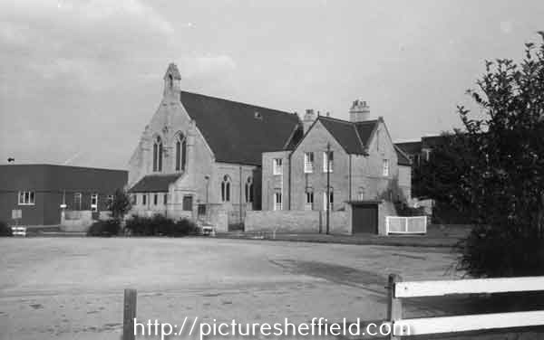
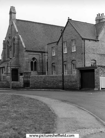
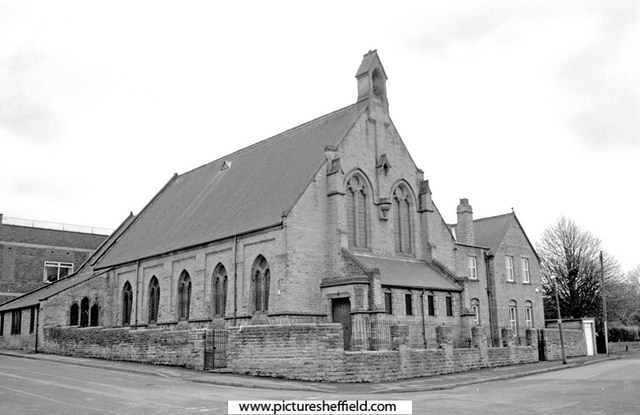
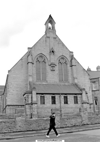
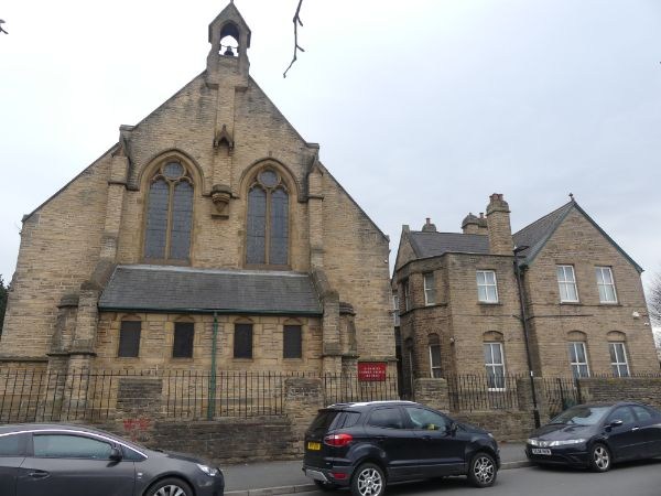
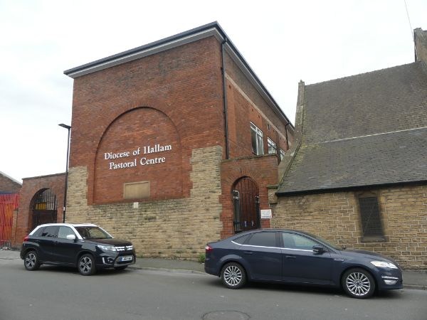
St. Charles Borromeo, Roman Catholic Church, St. Charles Street. Who was Charles Borromeo? https://en.m.wikipedia.org/wiki/Charles_Borromeo Taking Stock: https://taking-stock.org.uk/building/sheffield-st-charles-borromeo/#:~:text=It was dedicated to St,Serpentine in London in 1867. Sketch of St. Charles Borromeo Churchs05094 Plan of St. Charles' Borromeo Roman Catholic Church and School, St. Charles' Street, Attercliffe. 1876. https://www.picturesheffield.com/frontend.php?keywords=Ref_No_increment;EQUALS;arc04439&pos=94&action=zoom&id=151810 Church and Presbytery, St.Charles Street. 1987.t08439 u08403 28th January 2005.c00816 Photographer, David Bockingc00817 2021a07116 Photographer, Andrew Milroy Pastoral Centre, Roman Catholic Diocese of Hallam, St. Charles Street. 2021. a07115 PhotographerAndrew Milroy Plaque on Diocese of Hallam Pastoral Centre, Heppenstall Lane. 2006. https://www.picturesheffield.com/frontend.php?keywords=Ref_No_increment;EQUALS;t10471&pos=9&action=zoom&id=91432 St. Charles School, built 1871, rebuilt 1929 in memory of the Very Revd. Joseph Hurst V.F., founder and first rector, 1866-1905. St Charles Borromeo Roman Catholic Church, Sheffield, Parish Records. https://discovery.nationalarchives.gov.uk/details/r/76a87f80-ae50-499b-8153-d3d3cf131a64 Local Heritage List. https://local-heritage-list.org.uk/south-yorkshire/asset/7598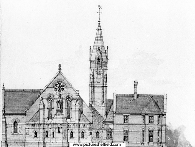
-
Property not named but a probability he owned Paddy's Goose. Charles Greenwood, Gentleman, St. Philips Road, Sheffield. Flood Claim includes amongst others (Spring Street & Watery Lane) "Relaying floors generally resetting Stoves and Chimney pieces making good pointing papering and painting etc. where necessary of property Public house Shop and Cottages in Love Lane and adjoining yards" https://sheffieldfloodclaimsarchive.shu.ac.uk/claimSummary.cfm?claim=3-2734
-
Flood Claim Link Restored: Henry Greenwood. Beerhouse Keeper, "Paddy's Goose", Love Lane, Sheffield https://sheffieldfloodclaimsarchive.shu.ac.uk/claimSummary.cfm?claim=7-5885
-
In 1723 John Justis leased from the Norfolk Estate "For building a cutlers grinding wheel in the nearest convenient place from Upper Horse Pitt. Close to the head of Moreton Dam...of one end and as many troughs as convenient, nothing to prejudice Slack Wheels above Moreton Wheel." 1724 took a lease of the completed wheel. In 1726 he mortgaged the leases of Sandbed and Owlerton Wheel to Joseph Broadbent. 1740, Broadbent built a new weir and 1742 enlarged the premises. Broadbent died in 1761 and Sarah and Thomas Broadbent are recorded as leasing the wheel. 1783 Thomas Broadbent, bankrupt. Plan of Sandbed Wheel held of the Earl of Surrey by the assignees of Thomas Broadbent. 1783. https://www.picturesheffield.com/frontend.php?keywords=Ref_No_increment;EQUALS;arc02739&pos=3&action=zoom&id=92280 Wheels, dam and goit clearly shown and named; numerical list with descriptions and acreages; height of fall given. Neepsend village, and lands belonging to the Earl of Surrey between Pye Bank Closes and Far Field, 1784. https://www.picturesheffield.com/frontend.php?keywords=Ref_No_increment;EQUALS;arc03991&pos=4&action=zoom&id=102795 Cath. Burton, late John Senior, No. 1 Pingle. Anne Hirst, 2 Horse Pits, 4 Upper Car Meadow, 5 Nether Carr Meadow, 6 Near Long Dole, 7 Farther Long Dole. Assignees of T. Broadbent, 3 Sandbed Wheel with the dam, tail goight, and vacant ground betwixt them and the river. William Stocks, 8 Ox Dole Close. Widow Vickers, 9 Stubbing, 10 Dole, 11 Marsh, 17 Smithy Croft (including the garden), 18 Acre Field, 19 Hilly Field. Joseph Clay, 20 Farthest Low Close, 21 Farthest Upper Close, 22 Middle Upper Close, 23 Upper Garden, 24 Nearest Upper Close, 25 Nearest Low Close, 26 Middle Low Close, 27 Lower Garden. Silvester Wadsworth, 12 Far Close, 13 Middle close, 14 Nearest Close, 15 several houses, etc. James Creswick, 28 a garden, 29 - 30. James Kay, 32 common. John Ward, 33 Commons south of the footway, 34 commons north of the footway. John Milner, 35 Commons, 35a garden (south of the footway). Thomas Burgan, 37 Commons, 38 commons, 39 commons (south of the footway). Jonn. Moore, 40, 41, 42 Pye Bank Close. Samuel Barlow, 16 a garden (inclosed from the waste grounds). Kinsey Winnell, 31 a small croft, smithy, etc. Shows Farfield, Neepsend, Pye Bank [closes], River Dunn [Don], 'Wood called Mire Acre Wood', [Cooks] Wood, Harvest Lane End, wear [weir]. The lease passed to merchant, Robert Trickett who assigned the lease in 1791 to a group of cutlers, one of whom was Peter Cadman (1794 list) By this time the Wheel had 52 troughs in three wheels and also a tilt. 1808 the tenants purchased the freehold from the Norfolk Estate. Advertised for sale 1816 & 1818 but the Cadman Association remained until 1852, selling to William Makin. Makin died 8th January 1856 and the Trustees kept the wheel as shown from their Flood Claim for £1418/11/7d. William Makin, gentleman of Attercliffe Listing: Damage to Clifton Works, Hillfoot near Sheffield, comprising: Grinding Wheel;Tilts; File Manufacture; Cottages; Stable; Dam; Shuttles; Weir; Goights; Culverts etc. in the occupation of Messrs William Makin & Sons lessees. https://sheffieldfloodclaimsarchive.shu.ac.uk/claimSummary.cfm?claim=6-5475 Claimed also: James Marchinton and Benjamin Makin carrying on business under the firm of William Makin and Sons, steel and file Manufacturers of: Clifton Works, Hillfoot and Attercliffe near Sheffield. https://sheffieldfloodclaimsarchive.shu.ac.uk/claimSummary.cfm?claim=11-5474 Thomas Yates, file cutter residing No.12 Court, new Edward Street. Employed at William Makin & Sons, Hill Foot had his claim dismissed. https://sheffieldfloodclaimsarchive.shu.ac.uk/claimSummary.cfm?claim=1-419 Selling, 1886 to John and Henry Andrews who eventually became Andrews Toledo. The claim revealed a steam engine boiler was in use although steam and water power was still used 1897 and even in 1907 listed as, still using Water Power. For added information see: Water Power on the Sheffield Rivers, edited by David Crossley with Jean Cass, Neville Flavell & Colin Turner.
-
Part of Robert Brightmore's late premises at the top of Church Lane bought by Wild and Pass.1820, 1824. https://www.picturesheffield.com/frontend.php?keywords=Ref_No_increment;EQUALS;arc04043&pos=4&action=zoom&id=90822 Also, other property of Wild and Pass and Ann Hancock in Orchard Lane and Sands Paver [Sands Paviours]. The plan has been cut and pasted to an outline of the adjacent properties and the first suggested line of Bow Street drawn across. Refers to John Sheldon, Orchard Lane, Church Street, William Pass, James Wild, Independent Methodists Society, Ann Hancock, John Milward, Bow Street. Firth College, Leopold Street / Bow Street, 1891 https://www.picturesheffield.com/frontend.php?keywords=Ref_No_increment;EQUALS;arc07488&pos=400&action=zoom&id=106877 Shows Sands Paviours.
-
The Golden Ball in Sheffield
Ponytail replied to Sheffield History's topic in Sheffield Pubs and WMC's
The Golden Ball public house, No. 69 Campo Lane from Vicar Lane. 29th June 1986.s30843 The Golden Ball public house, No.69 Campo Lane. https://www.picturesheffield.com/frontend.php?keywords=Ref_No_increment;EQUALS;t09557&pos=2&action=zoom&id=47272
-
The Golden Ball in Sheffield
Ponytail replied to Sheffield History's topic in Sheffield Pubs and WMC's
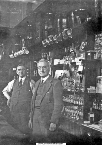
Townhead Street looking towards Campo Lane and the Golden Ball public house, gable belongs to the Burns public house, St. James Church Spire in background. 1898.y00595 Group including landlord Tommy Ward outside the Golden Ball public house, Townhead Street/Campo Lane. s09419 Information with the photograph. "Tommy Ward 'Senior' is on the left." Interior of The Golden Ball. 1937.s07031 Information with the photograph. "Mr. T. W. Brookes, on the right, was the landlord and Mr Tom Ward the barman.The Golden Ball was popular with actors from the Playhouse." St. James' Churchyard and rear Golden Ball public house, No. 69 Campo Lane and No. 10 Townhead Street. u00720 Ordnance Survey Map 1890, sheet no. Yorkshire No. 294.8.16. https://www.picturesheffield.com/frontend.php?keywords=Ref_No_increment;EQUALS;q00082&pos=7&action=zoom&id=152826
-
The Isle and Town Corn Mill, Weir & Goit
Ponytail replied to Ponytail's topic in Sheffield History Chat
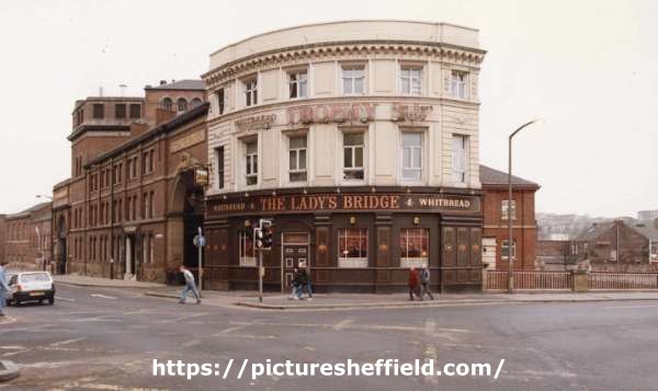
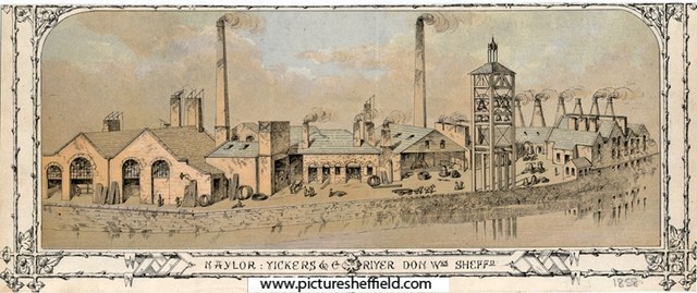
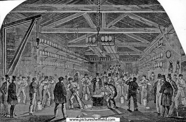
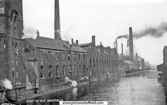
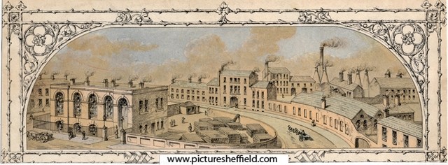
The Corn or Town Mill as it was known, was the most likely site of the medieval Corn Mill mentioned in the 12th Century built by the De Lovetots. The Mill in 1664 was leased to Thomas Cooke and Edward Hobson. In 1740 Thomas Ford held the lease and built a Cutlers Wheel adjacent. 1761, John Vickers took a 21year lease of the mill and "that cutler wheel of one end and ten troughs standing near the said corn mill and erected about ten years since at the sole expense of Thomas Ford late lessee" Building lots on Mill Sands. 1787. https://www.picturesheffield.com/frontend.php?keywords=Ref_No_increment;EQUALS;arc04166&pos=52&action=zoom&id=104251 The rough draft was made on arc04165. This plan is a fair copy. Tenants / owners: John Gallimore, Zachary Webster, Thomas Anderton, John Vickers, Joseph Jennings, James Duke, Richard Yeomans, William Marsden, James Green, George Taylor, and Jonathan Marshall. A plan of the Millsands, subdivided into gardens held of the Earl of Surrey, c. 1780s Marked: Town Wheel, Town Wheel Dam, River Don, etc. https://www.picturesheffield.com/frontend.php?keywords=Ref_No_increment;EQUALS;arc04165&pos=51&action=zoom&id=104250 Tenants: Benjamin Burdekin, William Grubb, George Taylor, John Barber, Nathaniel Smith, William Robinson, John Maltby, Thomas Sykes, John Arundel, John Buxton, James Bate, Zachary Webster, John Marshall, William Hill, Edward Frane, Joseph Bellamy, Joseph Barber, Robert Hague, John Milner, Charles Marshall, Thomas Wigfall, Joseph Jennings, Anne Lancelot, Hannah Moorhouse, Ann Matthews, widow of Edward Dickinson, Richard Yeomans, James Bettany, John Vickers, William Marsden, Ann Crofts, John Marshall, - Goodwin Clark, Denis Belk, Thomas Broadbent, Benjamin Bamforth, Luke Cadman, Hannah Haslehurst. Property includes houses, gardens, dye house, smithy, workshops, stable, yard, furnaces, a skinners yard, the town mill, etc. Plan of several building lots in the Mill Sands. 1787. https://www.picturesheffield.com/frontend.php?keywords=Ref_No_increment;EQUALS;arc03060&pos=42&action=zoom&id=96711 Property between the Town Mill Dam and the River Dun [Don]. Marked: Town Mill Dam; John Vickers; John Gallimore; Zachery Webster; John Anderton. Plan of the Ground in the Mill Sands [Millsands] held of the Duke of Norfolk by the Young Club. 1792 https://www.picturesheffield.com/frontend.php?keywords=Ref_No_increment;EQUALS;arc03063&pos=44&action=zoom&id=96713 Property between Mill Sands and the Town Mill Dam, including a narrow lane. 1794, Vickers held the mill and the wheel with 34 troughs employing 38 men. Plan of the lot of ground in Mill Sands on which several houses are erected by, or for James Duke. 1796. https://www.picturesheffield.com/frontend.php?keywords=Ref_No_increment;EQUALS;arc03068&pos=50&action=zoom&id=96722 Property between Mill Sands [Millsands] and the River Dun [River Don]. Plan of the tenements and ground in the Mill Sands held of the Duke of Norfolk. 1796. https://www.picturesheffield.com/frontend.php?keywords=Ref_No_increment;EQUALS;arc03067&pos=49&action=zoom&id=96721 Property, including steel furnaces, between Mill Sands [Millsands], the Tail Goight from the Town Mill and the River Dun [River Don]. 1805 the wheel and the mill were sold to Vickers by the Norfolk Estate. From 1825 Vickers developed the area of Millsands into a Steelworks with a rolling mill and the following years Naylor, Vickers were manufacturing steel on a large scale. The Rate books for 1845/6 show the Grinding Wheel empty; advertised to let 1849 but not recorded in 1855. Vickers was in the process of building a new Steelworks at Brightside when the Flood of 1864 caused much damage to the site at Millsands and Edward Vickers, George Naylor Vickers, Thomas Edward Vickers & Albert Vickers, firm of Naylor Vickers & Co. made a claim. Messrs. Naylor Vickers Co. https://sheffieldfloodclaimsarchive.shu.ac.uk/claimSummary.cfm?claim=2-2267 https://sheffieldfloodclaimsarchive.shu.ac.uk/claimSummary.cfm?claim=10-2267 Benjamin Vickers, damage to arch of Corn Mill. (Is this the Town Corn Mill) https://sheffieldfloodclaimsarchive.shu.ac.uk/claimSummary.cfm?claim=5-4766 George Dalton, night watchman to Naylor, Vickers & Co. https://sheffieldfloodclaimsarchive.shu.ac.uk/claimSummary.cfm?claim=5-4685 John Wood and others working at Naylor, Vickers & Co. https://sheffieldfloodclaimsarchive.shu.ac.uk/claimSummary.cfm?claim=3-2942 George Johnson contracting foreman at Naylor, Vickers & Co. https://sheffieldfloodclaimsarchive.shu.ac.uk/claimSummary.cfm?claim=5-4542 William Hopkins, warehouseman & office keeper, of Messrs. Naylor, Vickers & Co. Offices Millsands. https://sheffieldfloodclaimsarchive.shu.ac.uk/claimSummary.cfm?claim=5-4287 John Wood forgeman at Naylor, Vickers & Co. https://sheffieldfloodclaimsarchive.shu.ac.uk/claimSummary.cfm?claim=7-6157 Charles Firley Biclanski, merchants clerk at Naylor, Vickers & Co. https://sheffieldfloodclaimsarchive.shu.ac.uk/claimSummary.cfm?claim=1-668 1877, Vickers sold the site of the grinding and part of the mill dam to the brewers Tennant & Moore. Rate books of 1850's to the 1870's the Corn Mill is let to Samuel Price. Samuel Price snr. & Samuel Price jnr. (firm of Samuel Price & Son) corn miller, Millsands made a Flood Claim: https://sheffieldfloodclaimsarchive.shu.ac.uk/claimSummary.cfm?claim=3-2753 Samuel Price snr. had his claim for a broken leg dismissed: https://sheffieldfloodclaimsarchive.shu.ac.uk/claimSummary.cfm?claim=9b-54 Mary Marsden, spinster, Sam L. Price's, Millsands. https://sheffieldfloodclaimsarchive.shu.ac.uk/claimSummary.cfm?claim=4-3714 Joseph Walton, engine tenter, Rice's Yard, Millsands. (Is this a mistake? Should it be Price's Yard?) https://sheffieldfloodclaimsarchive.shu.ac.uk/claimSummary.cfm?claim=5-4660 Mary Dobbins, stable yard, Millsands. (Was this the stable of Naylor Vickers or the Corn Mill?) https://sheffieldfloodclaimsarchive.shu.ac.uk/claimSummary.cfm?claim=3-2604 There are other claimants at "Millsands" ... Some are identified as "Club Yard" (possibly Young Club in plan of 1792) "New Yard" "Millsands Leather Works" Also: William Parker, Spade & Shovel Maker, Millsands. https://sheffieldfloodclaimsarchive.shu.ac.uk/claimSummary.cfm?claim=7-6132 Recorded as Water Power abandoned in 1877 in the 1895 list of wheels. The Brewery occupied the site adjacent to Lady's Bridge naming it Exchange Brewery. They also made a Flood Claim: Tennant Brothers, Exchange Brewery, Bridge Street for damage to the Railway Hotel, Wicker. https://sheffieldfloodclaimsarchive.shu.ac.uk/claimSummary.cfm?claim=6-5378 Naylor Vickers and Co., Millsands Steelworks, Exchange Brewery, Wicker Tilt, etc., Lady's Bridge on Ordnance Survey Map 1890. https://www.picturesheffield.com/frontend.php?keywords=Ref_No_increment;EQUALS;y06791&pos=70&action=zoom&id=59986 Naylor, Vickers and Co, River Don Works (Millsands) 1858.s09790 Information with the image. "This print shows the River Don Works. Lest this should be confusing, it should be clearly stated that this Works was generally known as Millsands, admittedly on the River Don, and not the more famous River Don Works, down Brightside Lane, which were built betwwen 1862 and 1864. Here are the older works of this name, we see crucible furnaces, cementation furnaces and forge chimneys. Note the tall structure, quite clearly a test tower for cast-steel bells." Naylor, Vickers and Co., Millsands Steel Works, Offices in Bridge Street. 1858. s09887 Casting a Steel Bell, Naylor Vickers and Co., Millsands Workss10788 Naylor, Vickers and Co. specialised in the casting of steel bells. See: Sheffield Steel, by K.C. Barraclough Ref: 669.1 S For more information see Illustrated Guide to Sheffield and District 1879 , Pawson and Brailsford Ref: 914.274 S Rear of John Kenyon and Co., Millsands and River Don looking towards Sheffield Forge and Rolling Mills Ltd., Millsands Works with Exchange Brewery (extreme left)y02000 Lady's Bridge Hotel, junction of Bridge Street and Waingate and rear of Tennant Brothers Ltd., Exchange Brewery, fronting Bridge Street. River Don and Lady's Bridge Hotel. s10485 Lady's Bridge Hotel and Whitbread (East Pennines) Ltd., Exchange Brewery, Bridge Street from Waingate. 27th June 1969.u12322 For added information about Corn/Town Mill see: "Water Power on the Sheffield Rivers, edited by David Crossley with Jean Cass, Neville & Colin Turner." For further information about Naylor, Vickers & Co. See: Link to: Naylor, Vickers & Co., steel manufacturer, bell caster, Millsands. https://www.sheffieldhistory.co.uk/forums/topic/19521-naylor-vickers-co-steel-manufacturer-bell-caster-millsands/ For more information about Tennant Brothers, Exchange Brewery see: Link to: https://www.sheffieldhistory.co.uk/forums/topic/14722-tennant-bros-exchange-brewery/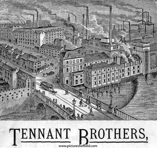
-
The Isle and Town Corn Mill, Weir & Goit
Ponytail replied to Ponytail's topic in Sheffield History Chat
The Isle was surrounded by the River Dun (Don), the tail goit and a road named Under the Water. Extract from articles and letters from The Sheffield and Rotherham Independent 1872/3, edited by Robert Eadon Leader 1875. "Reminiscences, it's Streets and its People." Pages 111&112. "Leonard: At the bottom of Newhall Street, are the offices erected some years ago by Naylor, Vickers & Co. They occupy the site of the old "horse dyke," in which lads used to bathe and paddle, and where the street watering carts were filled. Wragg: This part of Bridge Street was called " Under the Water" or " T 'under watter," and " The Isle" was where Tennant's Brewery now stands. In Water Lane, were some troughs, or rather a well — hence the name." Lady's Bridge Hotel and Tennant Brothers Ltd., Exchange Brewery, Bridge Street, established 1820. s09779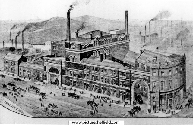
-
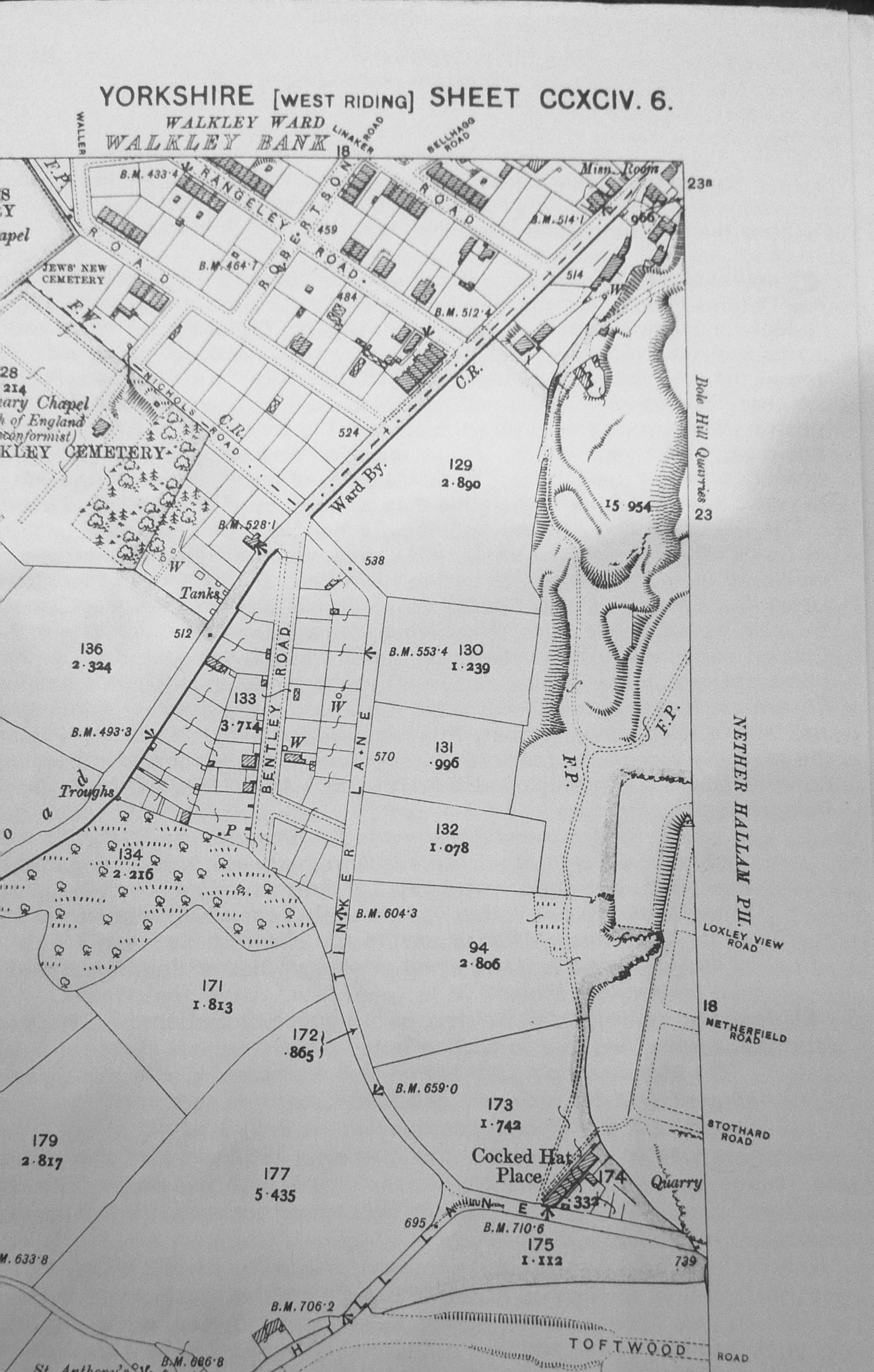
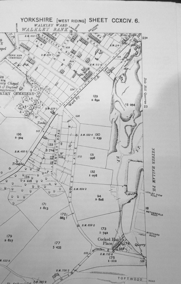
Preliminary Plan of the Walkley Land Society's Estate. 1877. https://www.picturesheffield.com/frontend.php?keywords=Ref_No_increment;EQUALS;arc06723&pos=6&action=zoom&id=105843 Shows Matlock Road, Walkley Road, Tinker Lane and Walkley Cemetery. Plan of the Upper Walkley Freehold Land Society's Estate. 1878. https://www.picturesheffield.com/frontend.php?keywords=Ref_No_increment;EQUALS;arc06724&pos=7&action=zoom&id=105844 Shows Bentley Road, Matlock Road, Walkley Road, Tinker Lane, Nicholls Road, Warren Road, Walkley Cemetery and Catholic Cemetery. Were the Allotments originally anything to do with the Walkley Land Society? ... These were plots for building on but they don't appear to have been built on by 1902 map. 1902 OS Map. 294.6.
-
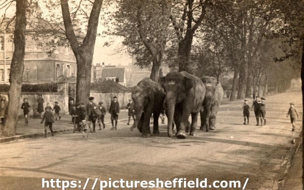
Circus Elephants in Norfolk Park. Date Period: 1900-1919. p01628 This image was originally part of the Tim Hale Photographic Collection. It was purchased at auction in September 2019 through donations from members of the public and a grant from the Graves Trust. Circus Parade, probably passing the works of Thomas William Sampson, electrical engineers. Date Period: 1940-1959. https://www.picturesheffield.com/frontend.php?keywords=Ref_No_increment;EQUALS;v04500&pos=16&action=zoom&id=69568 Chipperfield's Circus at unidentified location (Possibly Hillsborough Park 1972) https://www.picturesheffield.com/frontend.php?keywords=Ref_No_increment;EQUALS;t08901&pos=14&action=zoom&id=87634 Circus Horses at Hillsborough Park. https://www.picturesheffield.com/frontend.php?keywords=Ref_No_increment;EQUALS;t08923&pos=15&action=zoom&id=87655 Elephant at Gerry Cottle's Circus, Brightside Lane. 14th March 1990. https://www.picturesheffield.com/frontend.php?keywords=Ref_No_increment;EQUALS;s42181&pos=12&action=zoom&id=82385 Indian Circus Elephants on land near Meadowhead close to the Nag's Head Roundabout. 20th October 1993 https://www.picturesheffield.com/frontend.php?keywords=Ref_No_increment;EQUALS;s42319&pos=13&action=zoom&id=82614
-
A Plan of the Mill Sands in Sheffield divided into Gardens and Tenements held of the Earl of Surrey. 1781. https://www.picturesheffield.com/frontend.php?keywords=Ref_No_increment;EQUALS;arc02092&pos=162&action=zoom&id=76129 A large plan of the whole area between the Town Mill Dam and the River Don including the Town Mill and the Steel Furnace; most of the Tenements (coloured) are Gardens but there are some Houses, Smithies, Skinner's Yards, etc; also Cutlers Grinding Wheel, the Tail Goight, Steel Furnaces; numerical list with Tenants names, descriptions and measurements. The Isle, held by John Goulden and John Froggatt of the Burgesses, showing Land taken for widening the street in 1795. https://www.picturesheffield.com/frontend.php?keywords=Ref_No_increment;EQUALS;arc03800&pos=1337&action=zoom&id=99444 Marked: Castle Green; Street called Under the Water; Waingate; Weir; bye Wash; bye Goit; River Dun (Don) & Lady's Bridge. Town Land in Waingate, Castle Green and Bridge Street, c.1780 - 1790. https://www.picturesheffield.com/frontend.php?keywords=Ref_No_increment;EQUALS;arc04279&pos=4&action=zoom&id=105930 Marked Castle Green Head, Wain Gate, Castle Green, New Hall Street, Under the Water, Water Lane. John Marshall (warehouse and steel furnace, tenements and workshops), Earl of Surrey’s land, [?new] Shuttle, Town Mills Tail Goight, Well, Samuel Morris Tenement, Wear [Weir], The Isle, arched watercourse. Also marked are 74 Jeremiah Ward; 76 Ann Castleton; 77 J. Spooner; 80-81 Dr Hawksley; 82 William Poles; 83 William Lord; 84 Ezra Twigg, William Parker, William Haworth; 86 Poor House belonging to the Town; Margaret [Lowe?], Widoe Chapman; Barnard Hanson; 86 Paul Wilkinson. [No No.] Thomas Wilde; 87 Charles Littleworth, John Spooner; 89 Late George Morton now Stephen Smith; 90 Joshua Wigfull; 91 Thomas Wilde; ; 94 - Martha Springfield, 96 John Scholey / Aughton / late John Turner, water land / well, Thomas Wilde William [Pill?]; 97/97a Samuel Genn and James Smith; 99 – Town land (houses and several workshops), James Kenyon, 101 - Henry Crawshaw. Plan of the Orchard and Garden in the Mill Sands belonging to the Duke of Norfolk, c. 1770-1778. https://www.picturesheffield.com/frontend.php?keywords=Ref_No_increment;EQUALS;arc03058&pos=27&action=zoom&id=96543 Full title: A Plan of the Orchard and Garden in the Mill Sands belonging to the Duke of Norfolk, the tenant right whereof is convey'd from [M.] Bridden to J. Marshall; and of the parcel of Town Land and tenements thereon contiguous to the said Orchard Property between Mill Sands, the Mill Tail Goight and the River Dun [Don]. Includes The Isle. Also shows a bridge. Named: Widow Broadbent; Dennis Pepper. Two tenements in Under the Water occupied by Robert Turner and Nanson and Co. 1804. https://www.picturesheffield.com/frontend.php?keywords=Ref_No_increment;EQUALS;arc03801&pos=154&action=zoom&id=99472 Plan of the Cutler’s Grinding Wheel belonging to the late John Vickers at the Town Mill showing also some adjoining property. 1828. https://www.picturesheffield.com/frontend.php?keywords=Ref_No_increment;EQUALS;arc03657&pos=149&action=zoom&id=99207 Marked: Bridge Street; Colson Crofts; Mill Lane; Water Wheel; Grinding Wheel & Goight (Goit).
-
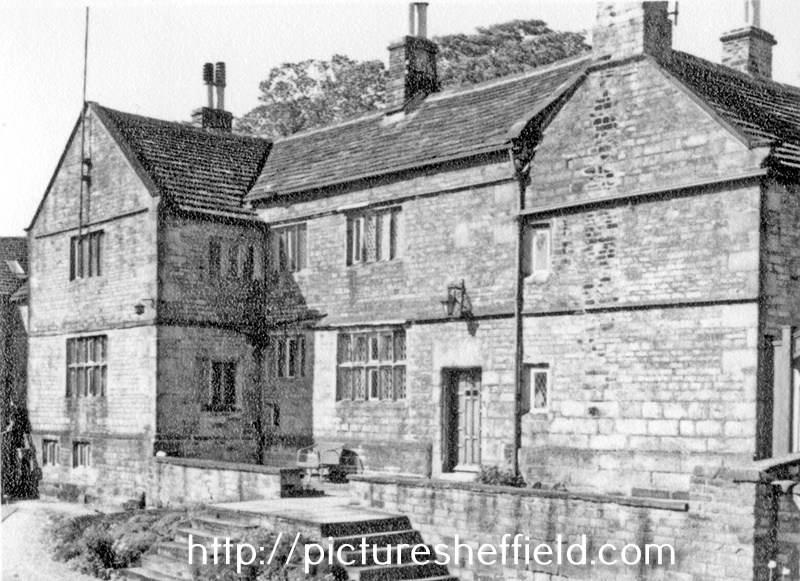
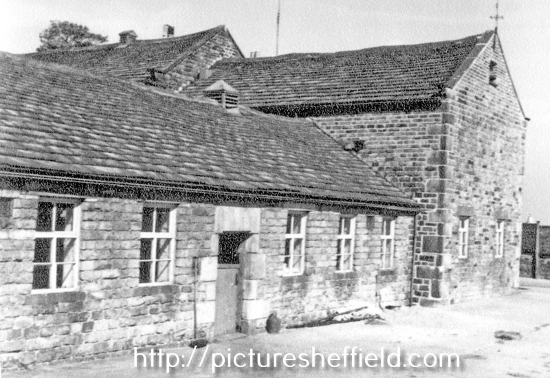
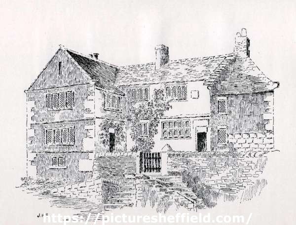
Fulwood Hall, Harrison Lane. 27th May 1952. t01618 Photographer: N V Bell. Mentioned in deeds of the time of Henry VII, although has a date stone of 1620, probably the date of some alterations. Home of the Fox family until 1707. In 1942, became the residence of the Fairest family. Artists Impression of Fulwood Hall, Harrison Lane 1924.y14229 J. H. Stainton (illustrator) Image from The Making of Sheffield, J. H. Stainton (E. Weston and Sons, 1924) (page 264) (Sheffield Local Studies Library: 942.74 S) https://www.picturesheffield.com/frontend.php?keywords=Ref_No_increment;EQUALS;p00914&pos=65&action=zoom&id=97539 https://www.picturesheffield.com/frontend.php?keywords=Ref_No_increment;EQUALS;p00915&pos=66&action=zoom&id=97540 https://www.picturesheffield.com/frontend.php?keywords=Ref_No_increment;EQUALS;p00916&pos=67&action=zoom&id=97542 Outbuildings at Fulwood Hall, off Harrison Lane. t01622 Fulwood Hall Estate in the Parish of Sheffield - the property of Thomas Watson and others. 1781. https://www.picturesheffield.com/frontend.php?keywords=Ref_No_increment;EQUALS;arc03971&pos=1372&action=zoom&id=102546 Refers to Long Oakney, Three Nook'd Oakney, Square Oakney, Great Okaney, Calf Croft, Fir Yard, messuage called Fulwood Hall and the outhouses, gardens, etc, Stubbing, Meadon, Hall Field, Bank, Broad Field, Dan Field, Water Stubbing, Ing Meadow, Well Field; Bower Hill, Broomh. Cottage [Broomhall Cottage], Catherine Offley rsquo;s land, land of Richard Palfrey and others, land occupied by William Woodhouse, junior.