Search the Community
Showing results for 'coal pit lane'.
-

Birley Collieries Branch Line
Lemmy117 replied to Paolo Coopio's topic in Sheffield Buses, Trams and Trains
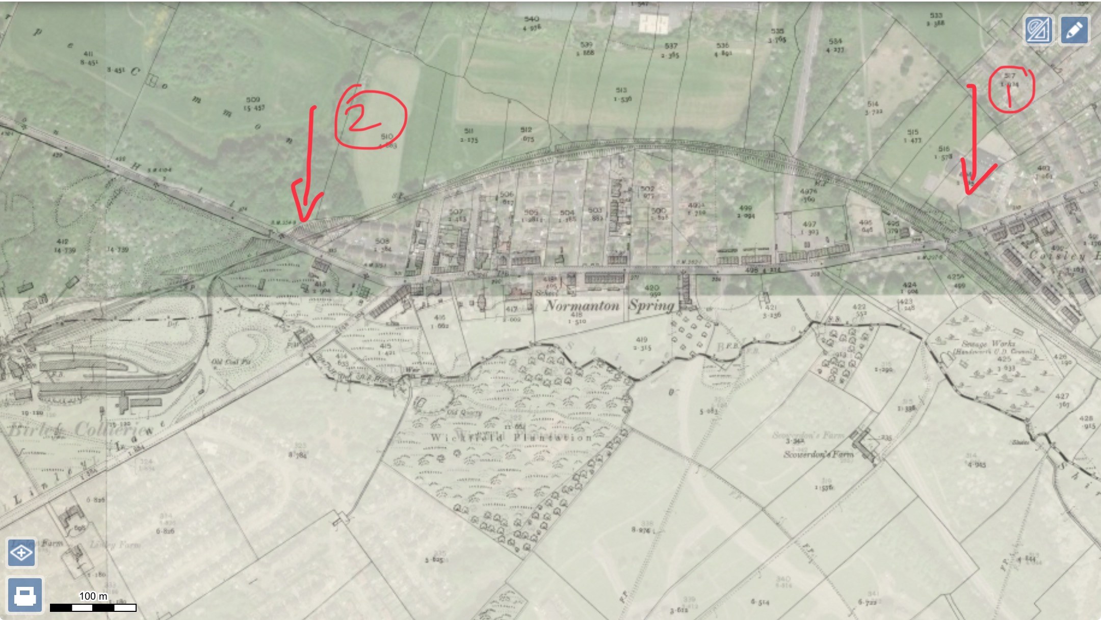
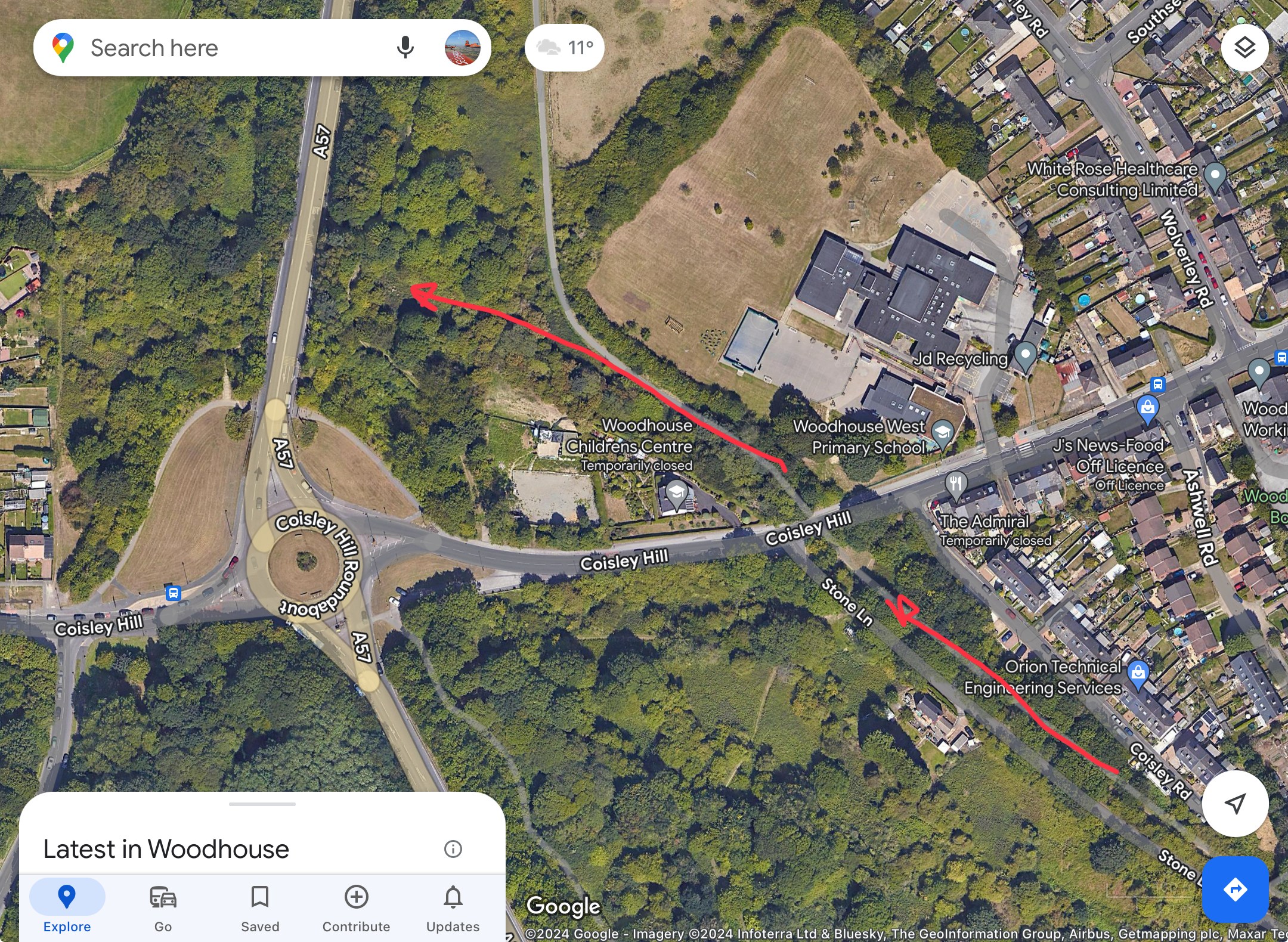
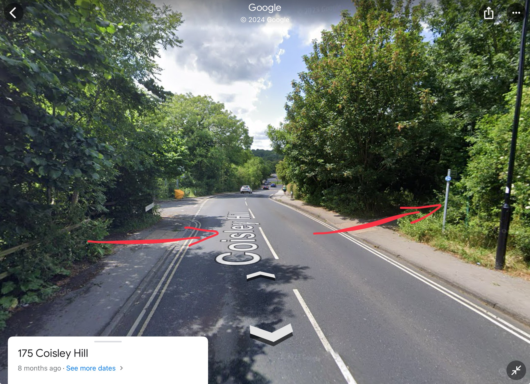
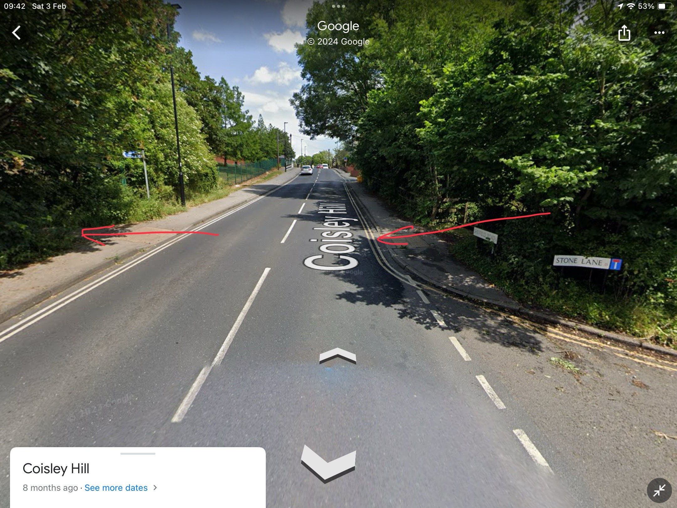
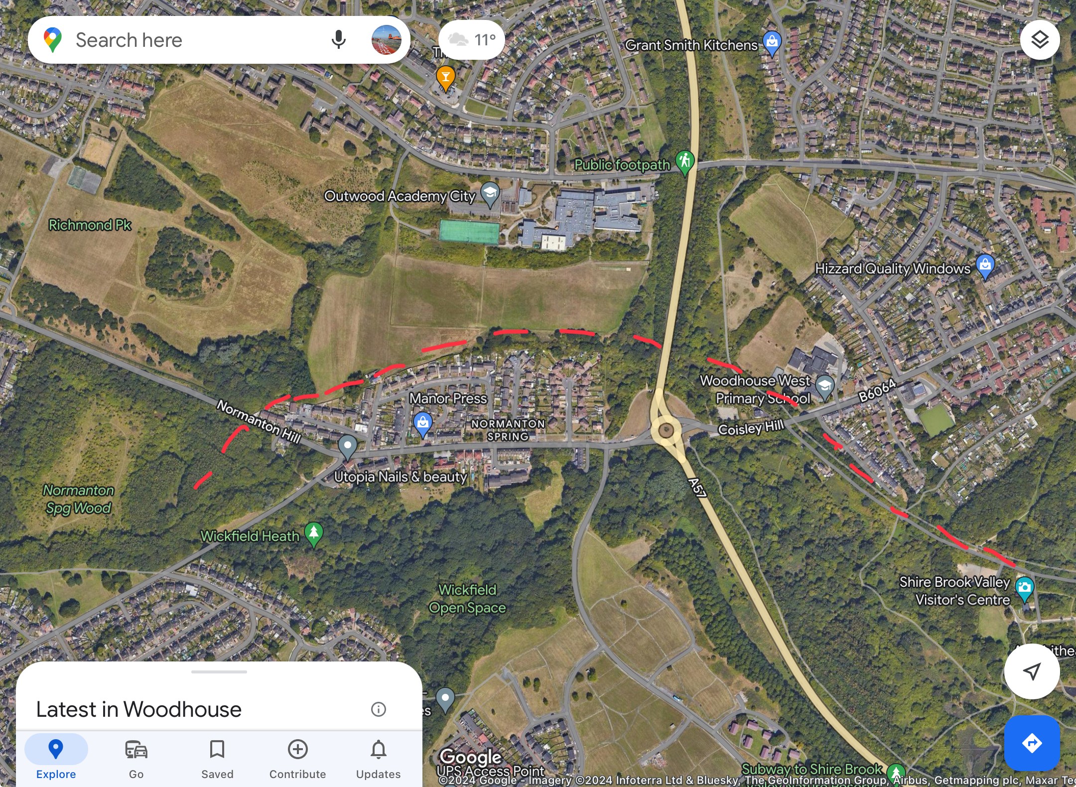
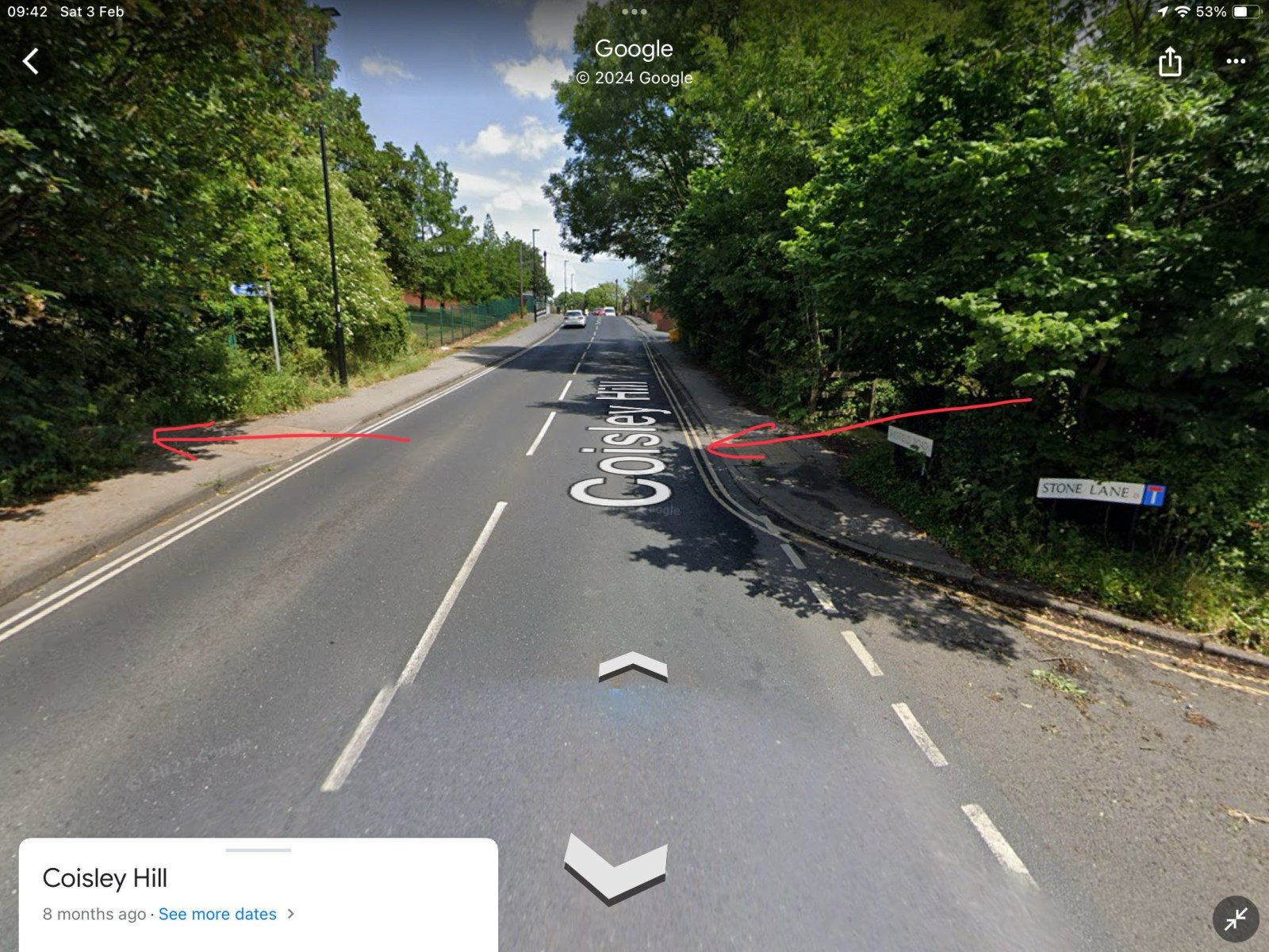
Thanks to that map it seems there was a bridge on Coisley Hill which I was not aware of. From the current pictures it seems the cutting has been filled in next to Stone Lane to bring the path up to road level. That's the good thing about this site, you learn something new every day! -

Birley Collieries Branch Line
RLongden replied to Paolo Coopio's topic in Sheffield Buses, Trams and Trains
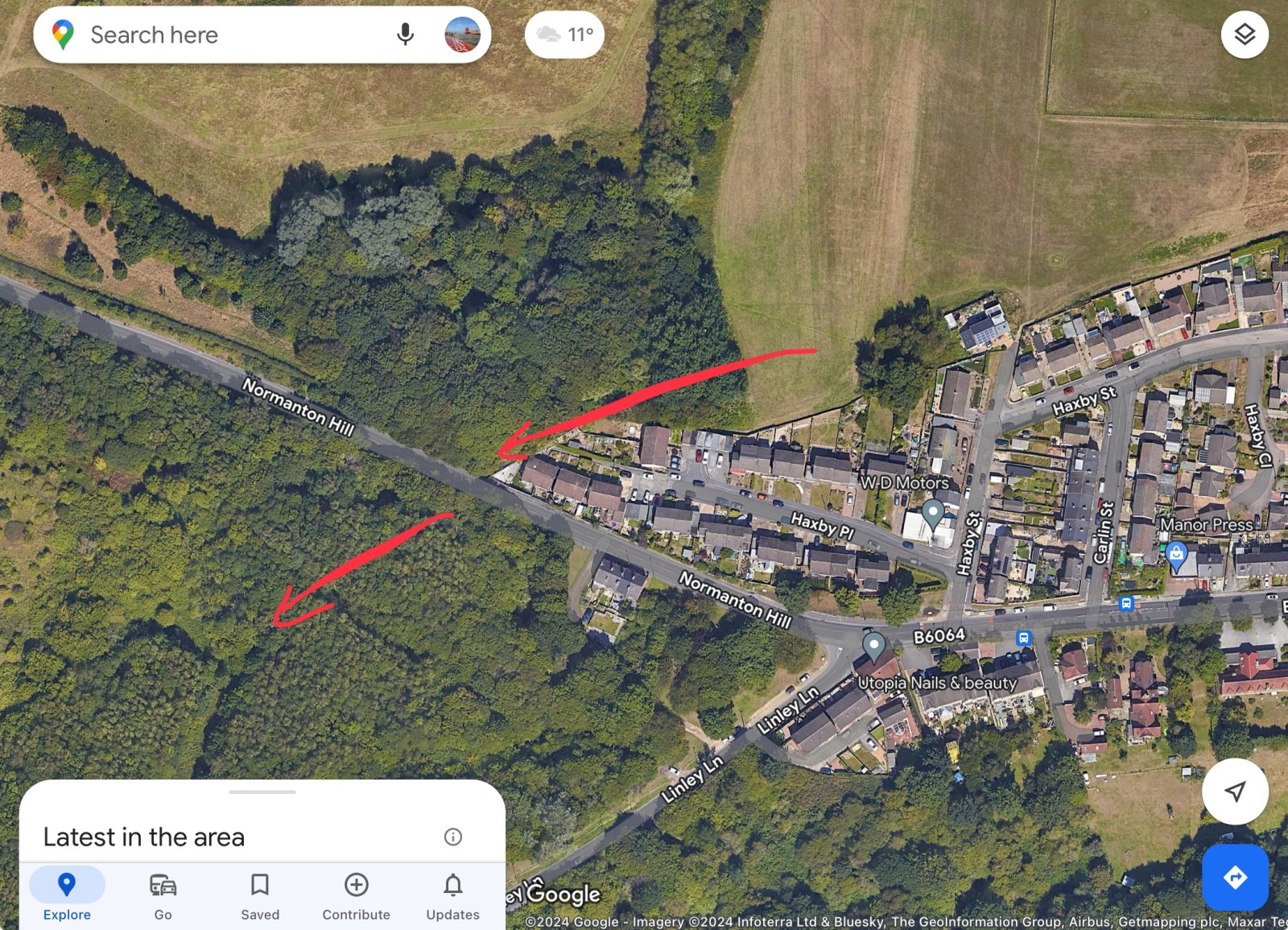
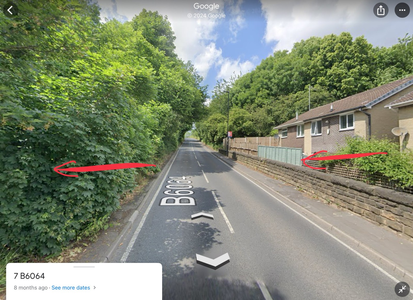
The line cut the road at 2 points. 1) Coisley Hill and 2) Normanton Hill. 1) You can see where the track bed was, as it’s now a part of the Trans Pennine Trail. It crosses Coisley Hill just up from Stone Lane, where the kerbs have been dropped either side 2) Just above the end house on the right going uphill, you can see the wall either side and the ‘drop’, where the tunnel cut under the road. Assume the level of the ground was backfilled to accommodate the houses, though if you peer over the wall/fence, it is still well below road level The trace of the line can still be seen in the vegetation, wall and property boundaries Hope this helps to visualise the route and crossing points?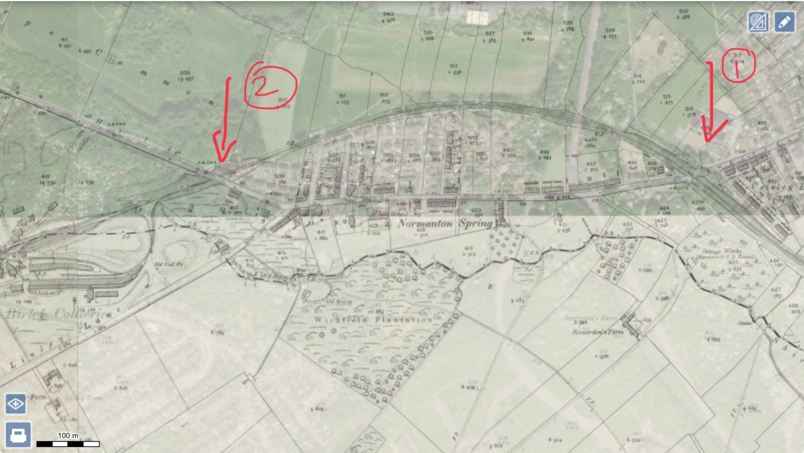


-

Birley Collieries Branch Line
boginspro replied to Paolo Coopio's topic in Sheffield Buses, Trams and Trains
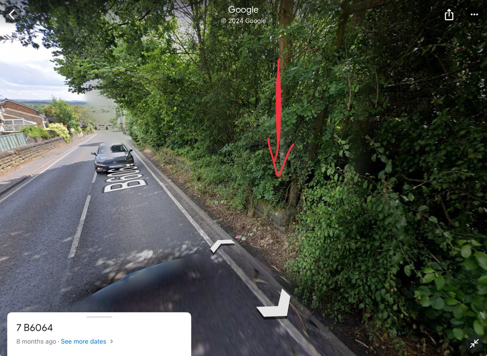
I may be wrong here and apologise if I am but the original picture put on by History dude looks to me like the tunnel/bridge at Coisley Hill just below the Block Houses on Coisley Road. If that is so as kids it was always known as The Tunnel though I think it was just quite a long under bridge. It seems to me to have been accepted as the bridge under Normanton Hill into Birley West pit but if you look at the 1938 picture above of a wagon loading coal at the land-sale site of the old Birley West site you can see how steep that hill is and the difference in gradient to the first picture. -
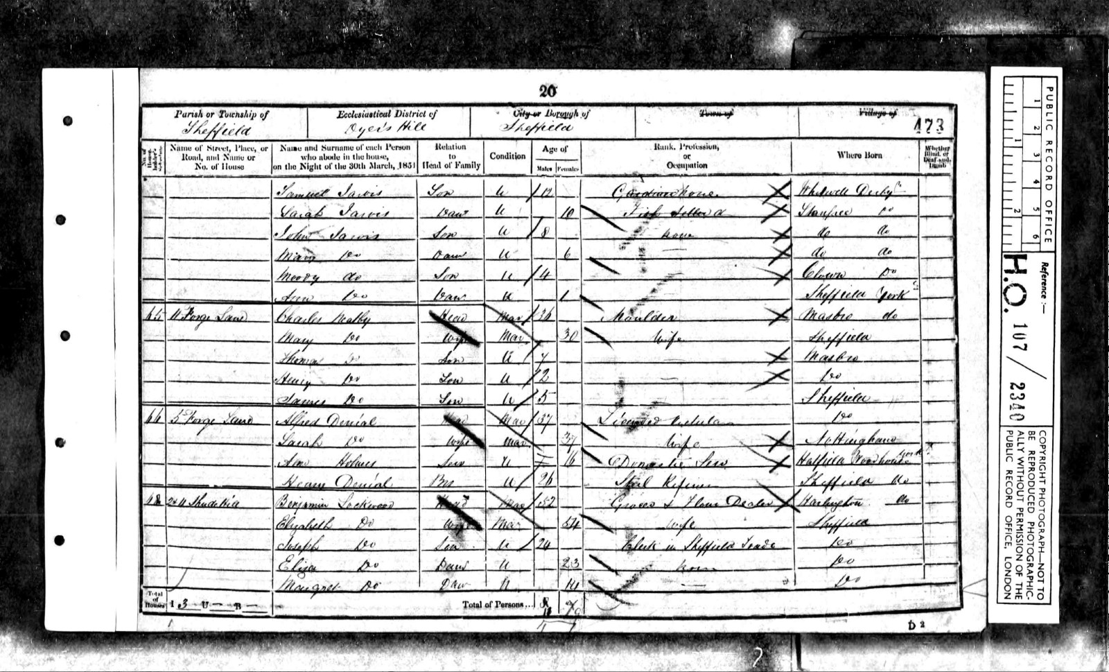
Plan of freehold premises in Forge Lane agreed to be purchased by William Gregson Hinde, Thomas Marrian and Henry Bolsover of William Webster. September 1837. https://www.picturesheffield.com/frontend.php?keywords=Ref_No_increment;EQUALS;arc03568&pos=178&action=zoom&id=98910 "A right of Road from Forge Lane through the covered passage into the yard at the back of the Public House is sold to these Premises and which road is to be used in Common with the other Premises of William Webster." Marked: Forge Lane; Golden Lion Public House; covered passage; joint wall; grate; midden; privy; passage & brewhouse. Also marked: John Grundy & late James Shemeld. A Map of the dams, goights and other works belonging to the Pond Forge Co together with some other intermediate properties. 1820. Shows Forge Lane and Premises marked T Rawson & Co., probably the Golden Lion. https://www.picturesheffield.com/frontend.php?keywords=Ref_No_increment;EQUALS;arc04213&pos=22&action=zoom&id=105197 Forge Lane later named Shude Hill. Golden Lion situated next to Ponds Works and backed onto Ponds Dam. Shude Lane, derelict premises, opposite Ponds Works, building on extreme left was No 2, Golden Lion public house. s02113 Shude Lane, Left Image, Shude Lane from junction of Shude Hill and Pond Street, Marsh Brother's Pond Works, right, second building on left, No 2, Golden Lion public house, Right Image, Shude Lane looking towards Shude Hill from junction with Shemeld Croft. 1889. s02112 Photographer: Marsh Brothers Chimney belongs to Electric Light Works. Buildings on right were demolished several years later. Shude Lane, derelict premises, looking towards Shude Hill, premises on right include No 2, former Golden Lion public house. s02114 Shude Lane, derelict premises, opposite Marsh Brother's Ponds Works, No 2, former Golden Lion public house, left. s02115 Sheffield History A-Z Public Houses. Golden Lion 3 or 5 Forge Lane (also 2 Shude Hill) Open. 1822 Closed. Comments. 1882 Old Golden Lion 1822 Mary Webster 1825 Mary Webster 1828 George Greaves 1830 William Swallow 1833 William Swallow 1834 James Askam 1837 Samuel Gray 1839 James Bland 1841 John Branch 1845 John Askham 1846 John Askham 1849 Alfred Denial 1851 Alfred Denial (5, Forge Lane - census) 1852 Alfred Denial 1854 George Elliott 1856 J. Staniforth 1859 F. Middleton 1862 William Etches 1864 Mary Baxter Alfred Denial - 1851 census. 5 Forge Lane.
-
Estates of the late Joseph Ellin, esquire, very valuable freehold building land, villa residences, works and dwelling-houses in and near Sheffield. 1868. (property near Sylvester Wheel) https://www.picturesheffield.com/frontend.php?keywords=Ref_No_increment;EQUALS;y11246&pos=59&action=zoom&id=82993 Bramall Lane; New Hereford Street; Sylvester Street; River Porter; Jessop Street; Eyre Lane; Jessop Lane; Arundel Street; tail goit. Messrs Robertson & Carr; Executors of the late William Butterell & John Snow.
-
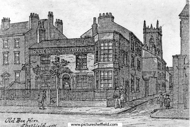
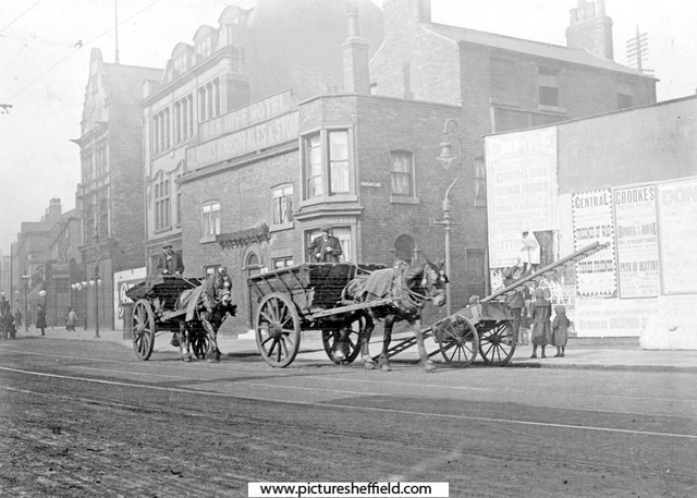
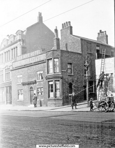
Artists Impression of the Bee Hive Hotel, No 240, West Street. Portland Lane, right. St. George's Church in background. The railings were there 1870-1880.s06859 Extract from: Reminiscences of old Sheffield, it's Street and its People. Editor Robert Eadon Leader, from articles and letters in The Sheffield and Rotherham Independent 1872/3. Page 155. "I well remember the time when the house, now enlarged and occupied as the Bee Hive public-house, was built in the cross garden walk (now Glossop Road) just mentioned, which terminated at the top of Broomhall Street. (then called Black Lamb Lane) It was erected by a shoemaker, named Thomas Rose. He was a little man, wore top boots, and kept a hive of bees in the garden beside the house. He got a license for the house and called it the Bee Hive. His pear tree (in the sketch) on the front yet retains enough vitality to show yearly a few leaves. With the exception of the old houses with gardens and palisades at the top of West Street, and the large house in Broomhall Street, beside which until lately the rooks have built, there were, I believe, no houses (except some garden cottages) from Portobello down to Holy Green, and the top of Bright, Gaol, and Young Streets. All the intervening space was occupied with fields and gardens." It was in 1817 that the Town Trustees agreed to lend towards the making of a Turnpike Road from Glossop to Sheffield providing the said road enters the town through West Street. and as the Beehive was earlier than Glossop Road we can fix the date of its erection somewhere in the opening years of the nineteenth century. s00470 Photographer: B E Drury There was also stabling to the rear. Photographs by C H. Lea of the Bee Hive Hotel in 1913.y01684 Night soil carts passing the Beehve Hotel, Portland Lane, right. Night Soil Carts collected the human waste from the Earth Closets, Water Closets (WC's) gradually replaced them. y01682 A Bill Poster on West Street at the junction with Portland Lane; balancing on his ladder across from the Beehive Hotel. y01683 Ordnance Survey Map, sheet no. Yorkshire No. 294.7.25. 1889. Bee Hive Hotel top left. https://www.picturesheffield.com/frontend.php?keywords=Ref_No_increment;EQUALS;q00075&pos=7&action=zoom&id=107161 Bee Hive Hotel, 10th February 1982. https://www.picturesheffield.com/frontend.php?keywords=Ref_No_increment;EQUALS;s21408&pos=3&action=zoom&id=24014 In the 1990s, The Bee Hive was extended and renamed the Foundry and Firkin. No 248, West Street Post Office, (later incorporated into the Foundry and Firkin) https://www.picturesheffield.com/frontend.php?keywords=Ref_No_increment;EQUALS;t09986&pos=3&action=zoom&id=90513
-
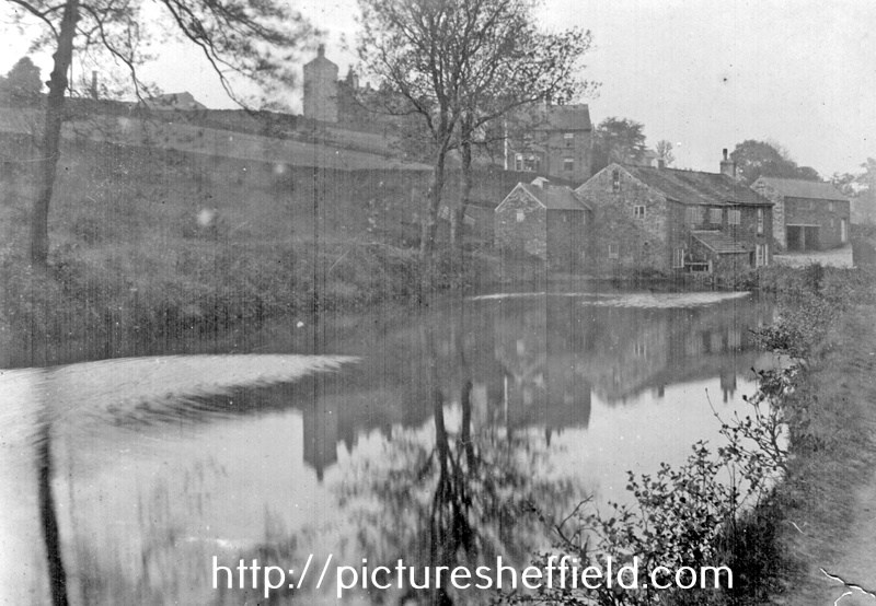
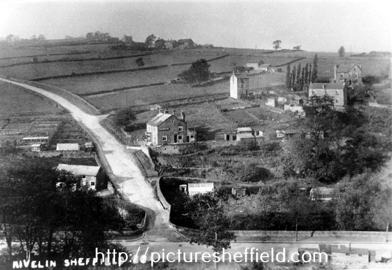
Holly Bush Inn, Hollins Lane, Stannington. 1973.u11810 Elevated view of Rivelin Valley Road (bottom) and Hollins Lane at Hollins Bridge, River Rivelin with Hollins Bridge Corn Mill (Riverlin Bridge Wheel) left; Holly Bush Inn (centre) and Hollins Farm (left) u05747 Holly Bush Inn, Hollins Lane, viewed from Walker Lane. 19th April 1978.s21806 Rivelin near Woodend View, Hollins Bridge Corn Mill, (known earlier as Rivelin Bridge Mill, prior to conversion to corn mill) and Dam, Holly Bush Inn, Holly Lane, behind Mill, Hollins Farm (side view) in background. u01693 Map of the Rivelin Valley Estate. https://www.picturesheffield.com/frontend.php?keywords=Ref_No_increment;EQUALS;y10390&pos=8&action=zoom&id=66881 Taken from a Report of Special Conference regarding the Development of the Rivelin Valley, Sheffield City Council, Sep 1934. Rivelin Mill, Rivelin Valley Road, Rivelin Hotel, St Michael's RC Cemetery, The Hagg, Roscoe Wheel, Hollins Bridge Mill, Holly Bush Inn, Walkley Bank Tilt, Walkley Bank Plantation, Mousehole Forge, Holme Head Wheel. E Partington, Estates Surveyor. Geography, photograph every grid square. The Holly Bush SK3288. https://www.geograph.org.uk/photo/1701642 Star Pubs & Bars, Holly Bush, includes photographs of the interior. https://www.starpubs.co.uk/pubs/holly-bush-sheffield
-
Norwood Grange, junction of Longley Lane, Herries Road and Norwood Grange Drive. 15th March 1983 s38698 December 1988.s38697 December 1988s38696 Norwood Grange now a Care Home. https://www.norwoodgrange.co.uk/
-
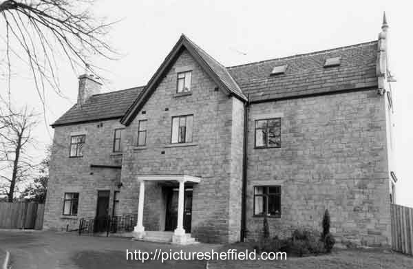
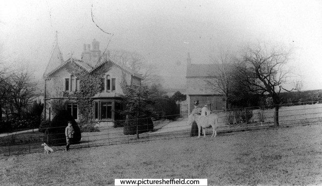
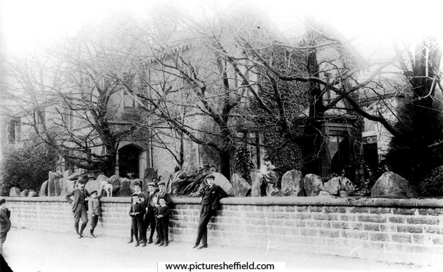
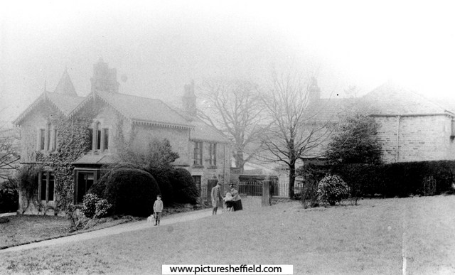
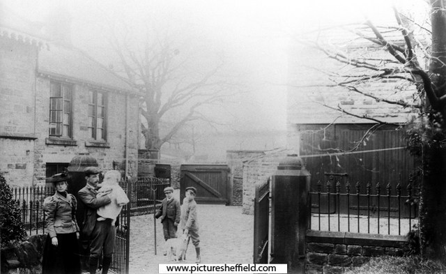
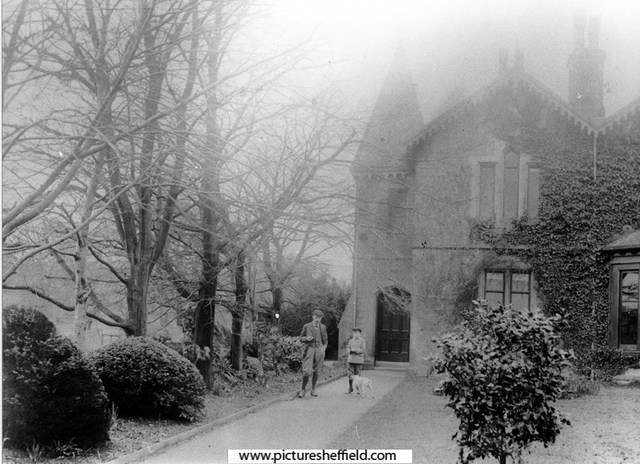
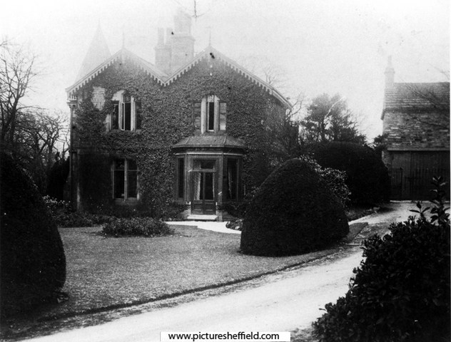
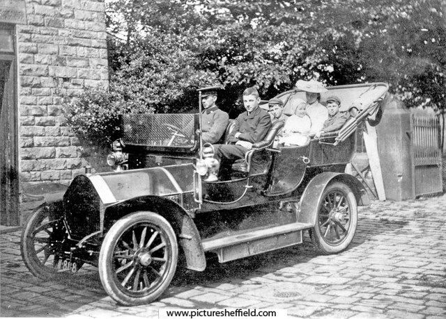
Greenoak House, Baslow Road, Totley At the time of the photographs (about 1900), rented from Ebenezer Hall of Abbeydale Park, by Athol Capron and family. The house was formerly a Farm and Greenoak Inn. Converted and extended into a family residence in the late c19th. See 'Totley District in Old Photographs', by Brian Edwards, Cat. No. 942.74 S. Mickley Lane, Totley, with a view of the buildings on Baslow Road including Greenoak House (the former Greenoak Inn). The smaller part in the middle was the original Greenoak Inn, built 1812. The extension on the right was added much later when it became Greenoak House. The part on the left was added early 1900's. s11439 The family of Athol Capron (consisting of his wife, 4 children and donkey) moved into Greenoak House in 1899, paying £90 p.a. rent to Ebenezer Hall of Abbeydale Park. Greenoak House from Baslow Road. s06092 Family of Athol Capron in Humber car at Greenoak House, Maurice (front seat), John (behind), Clare (on lap) and Gérard. 1906. s09007 From Donkey Field. Mrs. Capron and Maurice.s06089 Greenoak House from Baslow Road. A. C. Capron, Maurice (son) and Roy (dog) with village boys.s06087 Mr and Mrs Athol Capron with children, Maurice (with Roy the dog) and either John or Gerard in pram. s06088 In the yard, Greenoak House, Mr and Mrs Athol Capron with children- Gerard? in Father's arms. Maurice with the garden boy and Roy the dog.s06090 Mr Athol Capron, Maurice (son) and Roy the dog. 1906.s06091 General View of Greenoak and Heatherfield, Totley, leading to Main Avenue, before houses were built.s11438 Early construction of Heatherfield Estate, Baslow Road, Totley Rise. The Crescent, left. Greenoak Toll House is behind the telegraph pole. y01872 Photographer: R Sneath
-
Ivy Cottage/former Catch Bar Cottage, Barnsley Road
Ponytail posted a topic in Sheffield History Chat
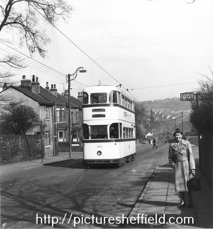
Ivy Cottage, Osgathorpe, corner of Barnsley Road and Batley Street with houses on Crabtree Lane in the background. 1905. s13399 u10512 Photographer: J.E.Vickers Former Pitsmoor Side-Bar or Catch-Bar. Ivy Cottage was built to catch Wayfarers travelling up Barnsley Road, who'd by-passed Pitsmoor Toll Bar by turning up Osgathorpe Road. Hence the phrase Catch-Bar as they 'had' to pay here. Tram No. 512, Barnsley Road looking towards Fir Vale, showing No. 307 Ivy Cottage, former Pitsmoor Side-Bar or Catch-Bar at the from the junction with Batley Street (left) and the junction with Osgathorpe Road (right). April 1960.s25156 Photographer: Mr. D.J. Smithies.
-
Link to: Little Man's Museum /Grapes Inn, Furnace Lane. https://www.sheffieldhistory.co.uk/forums/topic/12408-little-mans-museum-grapes-inn-furnace-ln/
-
Snippets of information about Furnace Hill from an extract of: Reminiscences of old Sheffield, it's Street and its People. From letters Editor Robert Eadon Leader, from articles and letters in The Sheffield and Rotherham Independent 1872/3. Pages 129-131. Twiss: There is a curious story told of the manner in which the further part of Westbar was raised to its present level. At one time, it is said, that portion between Westbar Green and Gibraltar Street was so low, that a person standing at the bottom of Furnace Hill might with ease have leapt upon a load of hay passing down the street. There was then a converting furnace at the bottom of the hill, which was worked with only one box or pot. By some mismanagement the whole mass of iron was melted together in one huge solid block of steel, there being in the furnace at the time some ten tons of metal. Nothing could be done with this when it was cold, and after it had lain in the yard a great number of years, proceedings began to be taken for filling up the road below. The best employment that could be thought of for the mass of steel, was to let it go towards filling up the road. The tradition has been handed down by very old men, and if there be any truth in it the steel is still there, waiting to astonish some antiquaries of the future. Wragg: The Bower Spring troughs were reputed to contain the best drinking water in the town. It came from Furnace Hill, as was proved when Messrs. Hudson & Clarke erected their engine. That stopped the water, and Messrs. Gaunt & Turton's works were then built where the troughs had been. Johnson: It was Mr. Turton who built the Bower Spring works in the old Workhouse gardens, leaving Mr. Gaunt on Furnace Hill. This would be between the years 1825-8. The history of Mr. Gaunt 's business is worth tracing. It was sold to Richard Griffiths, who, having come to the town from his native Wales as a carter to Brittain and Wilkinson's, of Carver Street, got initiated into the mysteries of steel converting, and ultimately became manager at Sanderson's. His son, for whom the business was intended, died; his son-in-law let it slip, and it was sold to Thomas Gatley, the son of a gardener at Attercliffe who had kept one of the stalls on the King Street side of the market. Young Gatley was himself apprenticed to Isaac Deakin, penblade maker (son-in-law of George Merrill, fork maker, Harvest Lane), and afterwards had a scrap shop in Gibraltar Street, near "The Cherry Tree." Then he was at the bottom of Furnace Hill, late Mr. Joshua Wortley's. Having acquired money, he bought Gaunt's business, and subsequently sold it to Mr. Wm. Jackson, Sheaf Island Works. He acquired much of the property about here. Like so many other worthies whom we have had to notice, Mr. Gatley was connected with Queen Street Chapel — until 1834, when he seceded and was the means of establishing Mount Zion Chapel, the congregation of which met in a room over a shop in Carver Lane while the chapel was building. Leighton: Furnace Hill was formerly called "t' Cock Tail;" I haven't the remotest notion why. "The Cock Tail Lady" was celebrated by Mather; and "Buck Hathard," the son of a tailor, was also one of the "characters" it produced. Mr. Peech, a scissor manufacturer here, was the father-in law of Henry Steel, who has made himself a name among the frequenters of the turf, and "t' Cocktail" had the honour of contributing a soldier to the Life Guards in the person of Samuel Wragg, who, and his son as well, was a cutler here. Wragg: The Quaker family, the Broadheads, have been associated with Westbar and the neighbourhood throughout the present century. Mr. John Broadhead, then a maltster, was in Scotland Street, next door to the chapel. Then he came to the bottom of Furnace Hill, subsequently crossing to the other side of Westbar, where the grocer's shop has been ever since. Mr. John Broadhead died in 1838. It is a little singular that not only did his son Alfred succeed to his own grocery business, but that four of his five daughters married grocers. Johnson: Two trade notes may be made here. One is that "frame polishing" may be said to have had its birth in Furnace Hill — that is polishing spring knives without the aid of steam or water power. It was originated by l Mark Blackwell (landlord of "The Grapes") and his brother George, by way of resisting a strike of the grinders. And it succeeded too. The other is that the first nail cut in Sheffield is said to have been made down the yard by the "Dog and Partridge the old public-house almost opposite to the bottom of the hill. Wragg: The Andrew family is closely identified with this locality. Old Joseph Andrew was a prosperous grocer and tallow chandler in Furnace Hill before this century began. Three of his sons, Isaac, Matthew and Joseph, were grocers, the first-named in West bar at the corner of Hicks Lane, the second in Charles Street, and the third, first (1825) in Paradise Square and afterwards (1833) in West Bar Green. Two other sons, twins, were William Henry and Albert George. They succeeded to the business of Messrs. George Butler and Co., spring knife cutlers, in Trinity Street, which was afterwards removed to Trinity Works, Eyre Street, the old premises becoming Mr. Longden's foundry. Isaac Andrew was, in his later years, blind. His brother Joseph was the father of John Henry Andrew, steel manufacturer, a member of the present Corporation, and of Mrs. Crowther, Fargate. The Butlers employed a larger number of men than any other house in the trade when the "statements" of 1810 and 1814 were made.
-
Dixon Lane, bridge over the river.
Ponytail replied to Roger Stevenson's topic in Sheffield History Chat
The Canal Basin measured for the Duke of Norfolk, with the line of Exchange Street plotted, [1817] https://www.picturesheffield.com/frontend.php?keywords=Ref_No_increment;EQUALS;arc04186&pos=50&action=zoom&id=104945 Marked: The Wicker, Blonk Street, Ladys Bridge, weir, River Dun [River Don], intended bridge [Blonk Bridge], Wain Gate, Town Hall, Castle Hill, Castle Street, Castle Folds, Hay Market, Tontine [Tontine Inn], Dixon Lane, Sheaf Bridge, River Sheaf [intended bridge], Broad Steet, hospitals and chapel [Shrewsbury Hospital], shuttle, warehouses, [canal] Basin, Soap House. Plan of Sheffield Castle about 1700 (1706?) drawn in the 1930s https://www.picturesheffield.com/frontend.php?keywords=Ref_No_increment;EQUALS;y09509&pos=56&action=zoom&id=64229 A plan of the House, Croft, etc. near the Hospitals held under the Duke of Norfolk by George Crook, containing in all 3a [acres], 3r [rods], 3p [perches] 1769. https://www.picturesheffield.com/frontend.php?keywords=Ref_No_increment;EQUALS;arc03384&pos=61&action=zoom&id=98620 Land between Broad Street, the River Sheaf and South Street. Crookes [Crook's] Croft, on the west bank of the Sheaf, south of the Shrewsbury Hospital; new Coal Road marked, with acreage taken for it; buildings, summer house and well; acreage of the whole. Coloured, on parchment. (Sheaf Lane, Sheaf Street, Granville Hill, South Street, Shrewsbury Hospital) -
Dixon Lane, bridge over the river.
Ponytail replied to Roger Stevenson's topic in Sheffield History Chat
Property on the corner of Castle Folds and Broad Street, on the bank of the River Sheaf, [1821-1827] https://www.picturesheffield.com/frontend.php?keywords=Ref_No_increment;EQUALS;arc03421&pos=3&action=zoom&id=98685 The site of Castlefolds Market. Shows Dixon Lane & Hospital Bridge. Needs a bit of manipulation to view. Scanned upside down. Plan of the property on the west bank of the River Sheaf, between the Hospital bridge and the bridge leading to the Canal basin [Exchange Street], [c. 1817-1821] https://www.picturesheffield.com/frontend.php?keywords=Ref_No_increment;EQUALS;arc03420&pos=2&action=zoom&id=98683 Premises numbered and listed with tenants and yardages. Tontine Inn. (site of Castlefolds Market). Dixon Lane. -
Dixon Lane, bridge over the river.
Ponytail replied to Roger Stevenson's topic in Sheffield History Chat
The Canal Basin measured for the Duke of Norfolk, with the line of Exchange Street plotted, [1817] https://www.picturesheffield.com/frontend.php?keywords=Ref_No_increment;EQUALS;arc04186&pos=5&action=zoom&id=104945 Marked: The Wicker, Blonk Street, Ladys Bridge, weir, River Dun [River Don], intended bridge [Blonk Bridge], Wain Gate, Town Hall, Castle Hill, Castle Street, Castle Folds, Hay Market, Tontine [Tontine Inn], Dixon Lane, Sheaf Bridge, River Sheaf [intended bridge], Broad Steet, hospitals and chapel [Shrewsbury Hospital], shuttle, warehouses, [canal] Basin, Soap House. -

Dixon Lane, bridge over the river.
SteveHB replied to Roger Stevenson's topic in Sheffield History Chat
Pond Hill (Dyer's Hill), and Harmer Lane, Bedford Dam (south), Ponds Dam (north). c.1853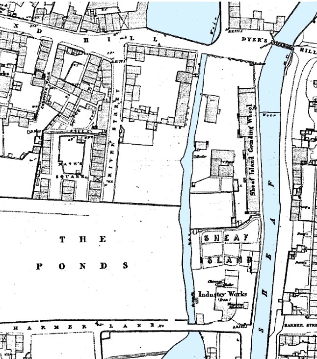
-
Dixon Lane, bridge over the river.
Ponytail replied to Roger Stevenson's topic in Sheffield History Chat
Plan of part of the town of Sheffield, comprising the site of the present and proposed corn, hay and cattle markets, also various improvements connected with the latter. 1827. https://www.picturesheffield.com/frontend.php?keywords=Ref_No_increment;EQUALS;arc04183&pos=13&action=zoom&id=104936 With illustrations of proposed Corn Exchange, elevation of the houses fronting the new Hay Market, and an elevation of the bridge over the Dun [Don]. Reference a - proposed corn exchange and office, b - erections on each side of Corn Exchange, c - weighing machine, d - row of shops. Inns in the immediate vicinity of the present Hay and Corn Markets 1 George, 2 King’s Head, 3 Angel, 4 Commercial, 5 Yellow Lion, 6 Tontine, 7 Healeys Hotel. The sites of the present Hay, Corn and Cattle markets are coloured red, and proposed are coloured blue. Other improvements are shown in yellow. Marked are: Market Place, Angel Street, Angel Inn, old corn market, King Street, post office, Change Alley, Kings Head, Fruit Market, Market Street, Norfolk Street, John Street, Commercial Inn, Hay Market, Yellow Lion, Pond Lane, Shude Hill, Fish Market, Dixon Lane, Tontine Inn, Castle Folds, Castle Hill, Healeys Hotel, Sheaf Bridge, River Sheaf, canal bridge, proposed Hay market, proposed Corn Market, Broad Street, Canal Basin, Canal Warehouse, market for fat cattle, lean cattle and milch cows, pig market, sheep market, River Dun [River Don], Willey Street, Blonck Street, Wicker, Cattle Market, Ladys Bridge, Bridge Street, Wain Gate, Town Hall, Killing Shambles and Castle Street. Plan of part of the town of Sheffield showing the existing markets, the property of His Grace the Duke of Norfolk, and the projected improvements. 1847. https://www.picturesheffield.com/frontend.php?keywords=Ref_No_increment;EQUALS;arc04187&pos=14&action=zoom&id=104946 Marked: Change Alley, Norfolk Street, Bakers Hill, Pond Lane, Market Street, Shude Hill, present Shambles, King Street, Old Hay Market, Angel Street, Post Office, Castle Street, Snig Hill, Town Hall, Waingate, Killing Shambles, Castle Hill, Castle Folds, Dixon Lane, proposed market [Norfolk Market Hall], River Sheaf, new market ground, fountain, Corn Market, Broad Street, Hay Market, Exchange Street, canal warehouse, Canal Wharf, Canal Basin, Blast Furnace Road, Sheaf Works, Wharf Street, Effingham Street, Maltravers Street, fair ground [fairground], cattle market, River Don, reservoir, Willey Street, Blonk Street, Wicker, Nursery Street, Wicker Lane, Stanley Street, Stanley Lane, Andrew Street, Johnson Street, Walker Street, Manchester Sheffield and Lincolnshire Railway, Midland Railway Station [Wicker Railway Station] and railway station [Bridgehouses Station]. -
Dixon Lane, bridge over the river.
Ponytail replied to Roger Stevenson's topic in Sheffield History Chat
This Map shows Dixon Lane and the "Bridge" known as Hospital Bridge and the confluence of the Rivers Sheaf & Don. A map of the dams, goights and other works belonging to the Pond Forge Co together with some other intermediate properties. 1820. https://www.picturesheffield.com/frontend.php?keywords=Ref_No_increment;EQUALS;arc04213&pos=15&action=zoom&id=105197 Boardman's Bridge, wear [weir], Porter Brook, goight, River Sheaf, Upper Dam, Sheaf Lane, bridge, Upper Forge Wheel, dam, Upper Forge, Sheaf Mill, steam engine, Lower Forge, grinding wheel, arched goight, tail goight, Shude Hill, Hospital Bridge, hospitals, Sheaf Bridge, Castle Orchards Wear [weir], River Dun [River Don], Pond Street, Forge Lane, Pond Well Hill. Late Joseph Ward, John Hounsfield, Josiah Blackwell, late Abraham Wright, S. Woodcock and Sons, Joseph Blackburn, Thomas Mearbeck and Co., S. Rawson and Co. [?Thomas Rawson and Co], Joseph Shimmeld, John Vickers, Sheffield Gas Light Co., S. and S. Darwin, Sarah Beeley, Widow Beardsall, John Hale, Widow Badger, and J. B. Ward. -
When was the course of the river in the Ponds and the Dixon Lane area covered over ? I'm talking about the stretch from Pond Hill to the junction of the River Don When open to view, were any photos taken ? Remains of the bridge over the river at the bottom of Dixon Lane were discovered when the new building at that location was being constructed. Time wasn't allowed by contractors for a detailed examination, what a shame !
-
Thomas Otley & Sons, a Chinaman and Teapot.
Ponytail replied to Kalfred's topic in Made In Sheffield
Looking towards Howard Street and Eyre Lane from Howard Street (Dinner Hour) Club for Working Women and Girls (left), former premises of Thomas Otley and Sons, Britannia Metal Manufacturers, left. 1963. s15501 Photographer: P Fletcher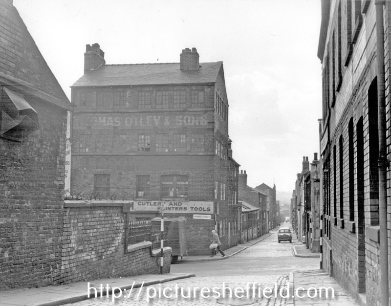
-
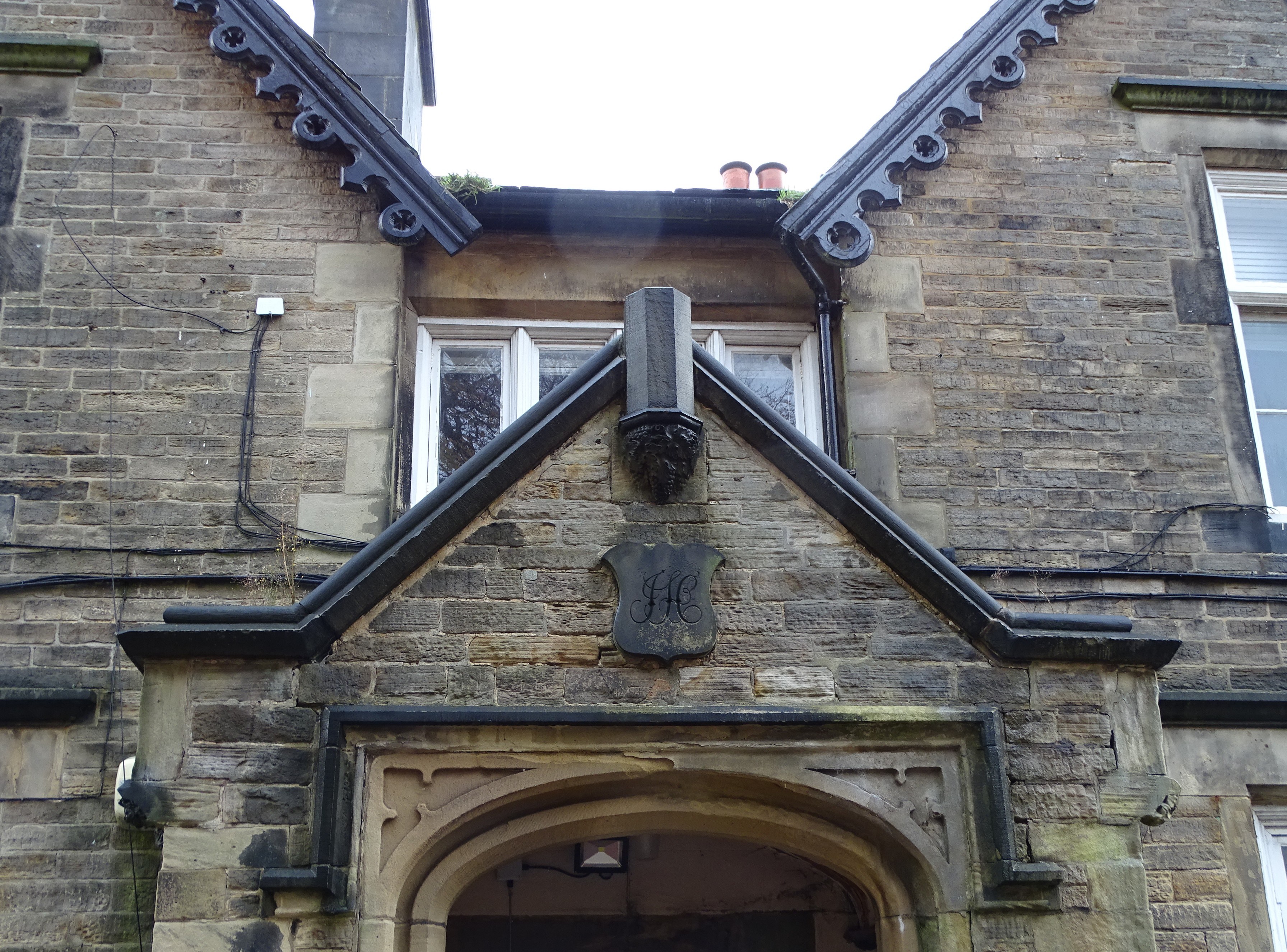
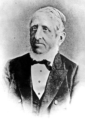
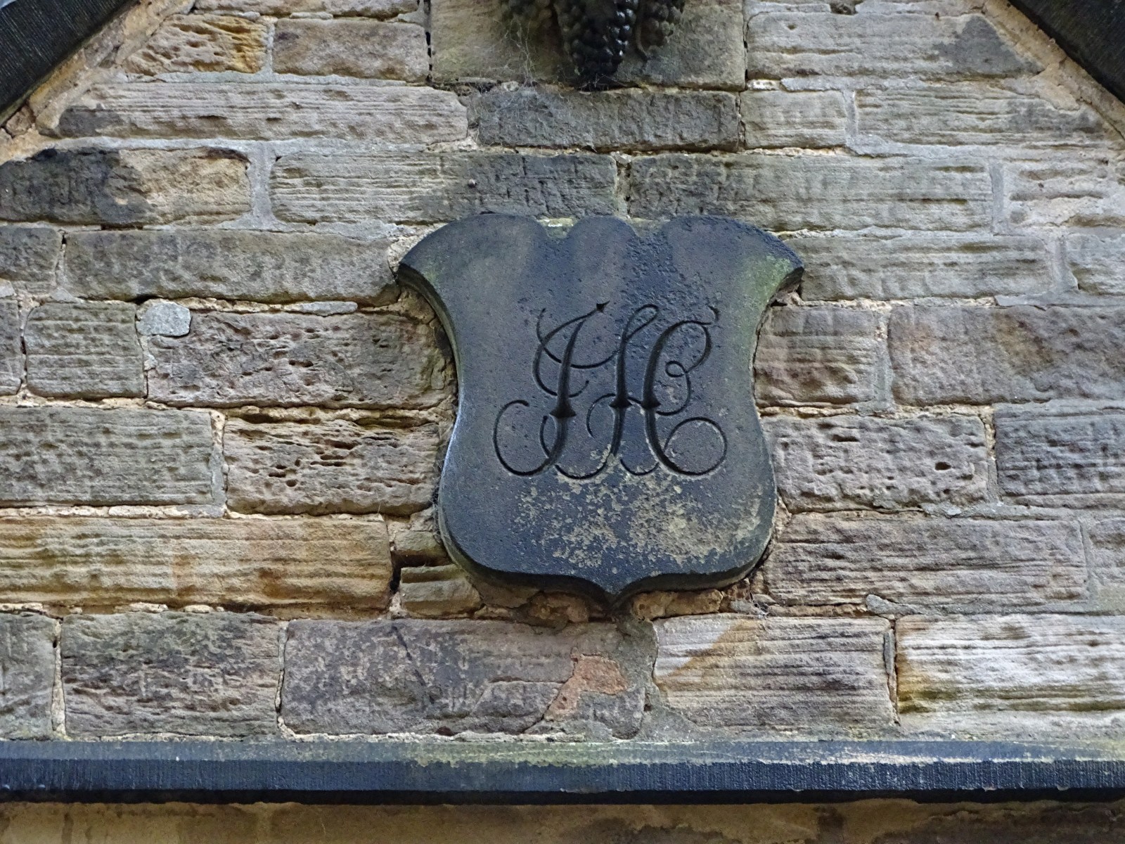
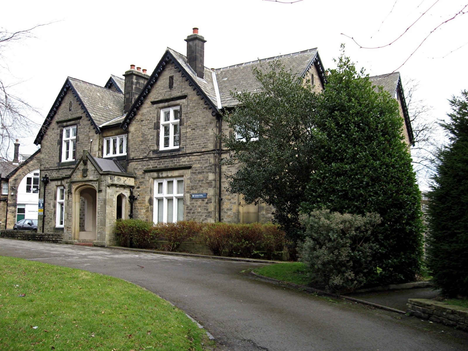
Mr John Hobson Scissor Manufacturer 38 Taptonville Road The finely worked initials of J H can be seen over the entrance to what was John Hobson’s front door at 38 Taptonville Road, the following pre-amble is from the great work done by the Broomhill Social History Group. In 1850 Sheffield was entering a period of major expansion and Broomhill was a favoured location for the homes of successful manufacturers and professional classes. In the 18th century the fields now occupied by Taptonville Rd were owned by Samuel Shore Esq., a local gentleman who lived in Tapton Grove, situated on Shore Lane where Tapton Hall (the Masonic Hall) now stands. A comparison of the 1851 map of the area with the present day illustrates how the pattern of the modern streets closely follows the pre-development field boundaries and lanes. Typically, the streets run through the centres of the original fields and the field boundaries are along the back garden walls of the houses. In 1850, Scissor manufacturer John Hobson purchased the fields that would become Taptonville Road and planned the development of the road, placing his own family home, Tapton Elms, in prime position on the highest ground at the head of the road. The gentility of the neighbourhood was assured by laying out the street with sizeable plots that were developed during the 1850s and 1860s with large, elegant houses of individual design standing in spacious gardens. Many of the successful industrialists in Sheffield were investing in property during this period. • No.1: was built in 1853 by Joseph Wright Bishop, one of a pair with 246 Fulwood Rd. • No’s 2, 4 and 6 were all built in 1855 by Robert Booth (originally a tailor, then property developer). • No’s 3, 5 and 7: were built in 1852 by William Greenwood, (property investor), who lived for a time in no.3 and then later in no. 5. • No.8 Built in 1861 by Charles Fleming (an engraver) as his own family home • No.10 Built in 1870 by J F Littlewood (a cooper) as his own family home • No’s 9 to 19: Built 1852 by George Deakin (originally a silversmith, then property developer) who lived for a while in no.17. The Hobson’s originated from Bradfield, the founder of the scissor empire, Joseph married a certain Miss Hinchcliffe who’s father was already making a good living producing scissors, Joseph Hobson is listed in the 1787 directory of the town, he was still in Bradfield at that time along with his son George, sometime before 1825 he had moved to Sheffield as he’s listed as a fine scissor maker, producing scissors from his works at 8 New Church Street, the yard where he made is scissors was named Hobson’s Yard after him, this street along with the yard was demolished and the present town hall was built over it, Josephs house was at 3 Surrey Street, it’s a strong possibility that he had access to the rear of his works from the rear of his house, by 1845, Joseph died on the 14th of September 1847 aged 75, the production was moved to 71 Arundel Street, his son John also moved house to 18 Surrey Street. I don’t know the circumstances but in 1879 John is working at 95 Arundel Street which probably stood near to where the Cossack stood, his old premises at 71 Arundel Street became the Talbot public house, which was run by two women, Miss Mary Norris and Miss Agnes Parsons in 1878ish. John Hobson’s family house was started in 1851 and completed in 1853. The gardens of Tapton Elms dominate the vistas north and south along Taptonville road. The ornamental garden to the south of the house’s principal façade has been lost under the two L-shaped disused student residence blocks now standing within this area. Further south, the half-acre walled kitchen garden of Tapton Elms has a highly decorative entrance gateway facing the street; all four boundary walls and gateways of this garden are still intact. Tapton Elms was the home for more than 70 years of the Hobson family. They were an old Sheffield family with a long history in the scissor manufacturing industry dating back to the 17th century .The Hobson’s’ business enterprises linked them to several of Sheffield’s best-known companies through a series of alliances and mergers, as well as trading under their own name for many years. For nearly half a century John Hobson drove the family business, it was known for its fine tailors shears and scissors, in the census of 1871 the firm employed 120 people half of which were women. John the driving force of the firm retired in 1882 and he died unexpectedly at Tapton Elms on the 20th of February 1889, after visiting his friend Frederick Mappin ( Mappin & Webb / Mappin's Brewery) at Thornbury, now Thornbury Hospital, as Tony Morton now knows after brilliant surgery there. The business was passed on to one of his sons, Albert, when John retired, who was just 21, this young man was severely crippled and could not walk without two strong walking sticks, when his father died he sold the business and order book to Joseph Rodgers, Albert along with his brother Wilfred joined the board of directors. Albert suffered great loss in the WW I his two sons, Leslie aged 19 was killed on 12th of July 1915 and his other son Alan lost his life on 28th of August 1916 age 23, for what? Tapton Elms is now being turned into flats by the look of it a sad end to a great house. I must point out that the history of Hobson & Son was gleaned from Geoff Tweeddale’s Directory of Sheffield Cutlery Manufacturers , thanks Geoff.

-
The Pheasant Inn (Beerhouse) / Stumble Inn
Ponytail replied to dunsbyowl1867's topic in Sheffield Pubs and WMC's
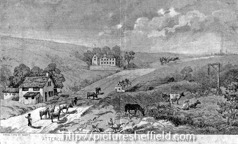
Artists impression of Attercliffe Common at the close of the 18th Century, near Greenland Engine Road (now Broughton Lane), buildings shown are the Arrow Inn, now pulled down, the Pheasant Inn and Carbrook Hall and gibbet post of Spence Broughton. t00983 Hides, engraver. On February 9, 1791 Spence Broughton along with John Oxley robbed the Sheffield to Rotherham postboy and stole the postbag containing a Bill of Exchange payable to Joseph Walker of Rotherham. Broughton was executed at York Tyburn and gibbeted at the scene of his crime where his remains hung for 36 years. Another Artists impression of Attercliffe Common at the close of the 18th Century. s13124 Engraver, Hides.
-
Morton Wheel, Philadelphia Works & Bacon Island
Ponytail replied to Ponytail's topic in Sheffield History Chat
Portrait of William Butcher (1791-1870), steel, cutlery, edge tool manufacturer and American trader. Painted in 1869 in the possession of Sheffield Town Trust. https://www.picturesheffield.com/frontend.php?keywords=Ref_No_increment;EQUALS;u02736&pos=34&action=zoom&id=38319 In 1819 brothers William and Samuel Butcher first became partners in a warehouse, workshop and yard in Eyre Lane producing a variety of edge tools; 1835 expanded to the neighbouring steel works of Mitchell Brothers and Co. in Furnival Street; 1845 steelmaking and forging at Philadelphia Works on the River Don and in early 1850's a recently vacated premises adjoining the Eyre Lane Works. Butcher Works are being now restored 2003/4. For more information see Giants of Sheffield Steel Ref: 923.842 S. Memorial to Eliza, wife of William Butcher of Five Oaks, died 23 May, 1833, aged 37, Also to James Thomas, son of Eliza and William, died 7 Jul 1822, aged 7 months, All Saints Church, Ecclesall. a04572 Photographer Pete Evans 2018. W. & S. Butcher Ltd. https://hawleysheffieldknives.com/n-fulldetails.php?val=butcher&kel=325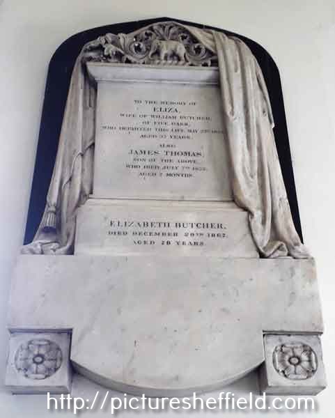
-
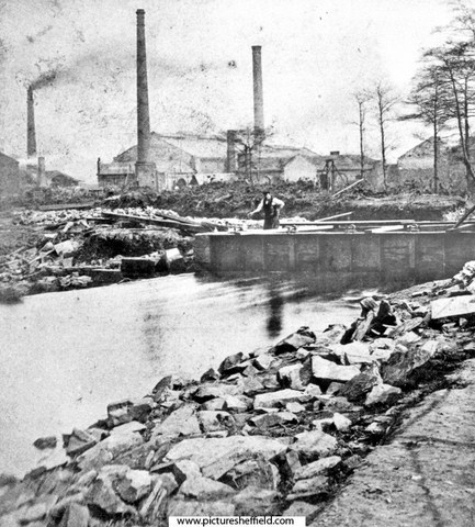
Morton Wheel, Philadelphia Works & Bacon Island
Ponytail replied to Ponytail's topic in Sheffield History Chat
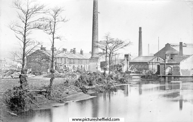
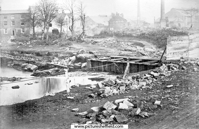
Sheffield Flood showing damage at Philadelphia after the inundation, searching for the bodies. Works belonging to William and Samuel Butcher, Steel Tilters and Rollers, Philadelphia Steel Works, Bacon Island, in background. 1864. u03594 From Sheffield Telegraph, 12/03/1938. For more information see: The Great Sheffield 1864 Harrison Ref: 942.74 S. The Collapse of the Dale Dyke Dam 1864, Geoffrey Amey Ref. 942.74 SST Damage at William and Samuel Butcher, Steel Tilters and Rollers, Philadelphia Steel Works, Bacon Island. y00945 Taken from 'Sheffield Inundation, 1864', Ref. 942.74 SQ. Remains of the 'Shuttle House', residence of James Sharman, at the head of Bacon Island; so called because he had charge of the shuttle by which the water was supplied to some mills and factories a little lower down. William and Samuel Butcher, Steel Tilters and Rollers, Philadelphia Steel Works, in the background. s00950 Remains of the 'Shuttle House', residence of James Sharman, head of Bacon Island, William and Samuel Butcher, Steel Tilters and Rollers, Philadelphia Steel Works, in background. House in background, left, is 'The Grove' y00944 Taken from 'Sheffield Inundation, 1864', Ref. 942.74 SQ. Extract from the Great Flood at Sheffield on 12th and 13th March 1864. Pages 58-64. THE FLOOD AT BACON ISLAND. A little lower down an island is formed by the river dividing into two branches,and this low-lying piece of land is called Bacon Island. The destruction here was very great, as the water swept completely over the island. In one of the houses there lived Mr. Howe, metal smith. The inmates were aroused by the Flood sweeping over the house; but it was strong enough to withstand the shock, and all the family escaped by getting up into the top bedrooms. The water filled the house up to the chamber floors. A large greenhouse was carried away, as was also the back kitchen. Doors were burst open, windows broken in, and all the furniture damaged or destroyed. On the south side of the island a stable, occupied by Mr. Greaves, treacle boiler, was knocked down by the flood, and such was the force of the shock that the stable wall dashed through the wall into the next house. A pony, belonging to Mr. Greaves, was drowned in its stall. The adjoining house was occupied by George Shaw, a miller’s labourer, and his family. The water filled the lower rooms, and floated the beds in the chambers. A portion of the foundation gave way, the house tottered, and its inmates every moment expected to be engulfed in the torrent which raged around. Their fears were happily not realised; for the house stood, and all was saved. GALLANT RESCUE OF A FAMILY BY A WATCHMAN. At the head of Bacon Island was the residence of Mr. James Sharman, known as the “Shuttle House,” so called because he had charge of the shuttle by which the water was supplied to some mills and manufactories a little lower down. In the house was Mr. Sharman, his wife, a daughter, two daughters-in-law, and four grand children, one of them being a baby. When the flood burst upon the island they were all asleep; but they were aroused by Police Constable John Thorpe, who was on duty in the neighbourhood, and saw the danger to which the Sharmans were exposed. Thorpe heard the roar of the Flood approaching, and with praise worthy promptitude and courage, he went to the rescue of others, even at the imminent peril of his own life. When the Sharmans were called up the lower rooms of the house were filled with water, and the bedrooms were being filled rapidly. The only means of escape was through the bedroom window; but even this means of egress was closed by an iron bar which had been placed across the window frame for greater security. By this time several people had come to the aid of the watchman, including George Walker, of Philadelphia, and his brother. Sharman, seeing that it was a question of life and death to himself and family, seized hold of the iron bar, and with the strength of desperation wrenched it from its holdfast. The window was now opened, but it was still a difficult matter to get out, as the water surrounded the house. The watchman and the two Walkers, however, stood on an elevation, and were not so much submerged as to be in personal danger. The watchman told the mother of the baby to throw it out to him, and she did so, though not without some hesitation lest her little one should fall into the Flood which was swelling and raging beneath. Her fears on that head were soon relieved; for the watchman caught the baby in his arms as neatly as though he had been an experienced nurse and not a protector of the nocturnal peace. The babe was deposited in a place of safety, and the next thing was to get out the remaining inmates of the house. It has been stated that a ladder was obtained, and that in this manner they escaped; but, it appears, there was no ladder in the question. One by one, the members of the family got out of the window, and were lifted down by the watchman and other persons who were helping. Of course the Sharmans had nothing on but their night clothes, and the awkwardness of their predicament may be imagined. Although there were nine people in the house all this occupied very little more time that it takes to narrate the incident. The last person had hardly been lifted out of the window when the house fell down with a loud crash. It was swept away so completely that not a vestige of it remains except the foundation. The Sharmans have since expressed the most lively gratitude to Thorpe, the watchman, for his intrepid bravery, which has also received notice in the form of one or two presentations from parties who thought that such conduct ought to be recognised and rewarded. After their narrow escape the Sharmans were taken to the house of a neighbour, where they were provided with clothing and other requisites. Of course they lost all their furniture, and everything they possessed. The following is Policeman Thorpe’s own account of the affair. He says:– I was coming down from Hillfoot about 12.30 p.m. I heard a great noise on the river as if a great rush of water was coming down through the gardens opposite to the old barrack wall. I saw that Bacon Island was in danger, and I ran with all speed to awaken the people, and warn them of the danger. I looked over the wall on the bridge leading to Bacon Island, and saw that the water was coming over the shuttle gates. I knew that the water had no business coming over there, so I rapped the family up and told them to get up as there was a flood coming and their house would be washed away. I then ran down Bacon Island, to awaken the other people, but I could only get half-way before the water was up to my waist, and pieces of timber and rubbish floating about my legs: so I ran back as fast as I could through the water, and tried to break open Mr. Sharman’s door, but I could not; and I told them to get through the chamber window, and I would catch them. The first they threw out to me was a young child. I ran up George Street, and knocked up a neighbour, and gave her the child. I then ran back, and received a second child; I did the same with it. I then ran back nine successive times and got them all out safe; the father being the last to leave the house. As soon as I received the father, I said to him “Run, now, for your life !” We had no sooner got on the main road than the house fell, and took the bridge with it, leaving nothing to be seen but one vast sheet of water. I then went and knocked the people up at the bottom of George Street. The following is the statement of an eye-witness:– I am a resident in the neighbourhood, and I was awoke out of my sleep by the cries of the unfortunate family of the Sharmans; I immediately got up and looked through my chamber window, and saw the watchman, up to his waist in water, carrying a young child in his arms up George Street. I got dressed immediately to go to his assistance, but before I could get to him he had saved the whole family, nine in number, and there was not a vestige of the occupier’s house remaining. After saving these, he roused up some occupants at the bottom of George Street, all the time up to his waist in water. He succeeded in rescuing them before the water got too deep in their houses. There were either four or five families at the bottom of George Street flooded in their houses, but owing to his timely aid he got them out, and locked their doors. When he had done all that possibly could be done, he remained true to his duty, in his wet clothes, shaking with the cold. The man seemed quite exhausted with fatigue; and being wringing wet through, there he stood till the sergeant came to him, two hours afterwards. I heard the watchman ask the sergeant if he could go home and change his wet clothes. The reply was— “I don’t know; I’ve got no order about that.” I thought that very hard indeed; but the man never murmured, but did his duty in his wet clothes from 12.30 until five a.m., when he went home. I write this on behalf of the bold watchman, who risked his own life nine successive times to save his fellow creatures. I understand he was a soldier before joining the police. He has served in the Crimea and India in the 33rd Regiment, and he bears a very good character in the neighbourhood of Hillfoot and Philadelphia for being a good watchman. It may here be stated that some time afterwards, the Inundation Relief committee voted £100 to reward John Thorpe, and other policemen who had made extraordinary exertions during the flood. SHOCKING DEATH OF A FAMILY AND EXTRAORDINARY ESCAPE OF A CHILD. On the South side of Bacon Island were two houses, which stood crosswise to a row of buildings previously referred to, in which lived George Shaw, and others. One of these houses was occupied by Geo. Wright, a furnace man, employed at Messrs. Butchers’, and the other by a family named Mappin. Wright was awoke in the middle of the night by the rush of the waters. He at once got up, and knocked at the partition wall to alarm his neighbours. Mrs. Mappin replied by knocking again, and in a moment afterwards she heard a loud shriek. Then all again was still, except the noise of the wind and the roar of the flood. When the water had subsided, it was discovered that the gable wall of Wright’s house had been carried away. At first it was not known exactly what loss of life there had been in this house. Mr. Wright had been to a funeral the day before the flood, and the neighbours were not aware whether he had returned or not. There is, however, No doubt that Wright was in the house at the time of the flood, and that he perished in its waters. There were also in the house Mrs. Wright, her young child, and an older child, a visitor, the daughter of Mr. Johnson, pork butcher, Sheffield Moor, with whom Mrs. Wright had formerly lived as servant. Mrs. Wright was drowned, and so was the visitor, the child of Mr. Johnson. Mrs. Wright’s child had a most extraordinary escape. After the subsidence of the waters, a young man climbed on a pole through the bedroom window, and there he found the little child asleep in its bed, unconscious of the danger it had escaped, and the terrible bereavement it had sustained. Even the candle which its parents had lighted in their terror when the flood came, was burning near the child, disclosing on its features the soft and peaceful slumbers of infancy. The young man took the child up, and said to it, “Where are your dada and mamma?” “They have gone out of the window,” replied the little innocent. The child was taken out of the ruins of its father’s house and conveyed to a place of safety. Afterwards the Johnsons applied for the child, thinking that it was their child that had escaped. Their distress on finding that their child was the lost one may be imagined. We understand, however, that Wright’s child which escaped has been handed over to Mr. Johnson, and that he has undertaken the care of it in place of his own. Johnson’s child was not found till more than two months afterwards, when it was got out of the river Don at Kilnhurst. The body was in an advanced state of decomposition, and the features were unrecognisable. One of the fingers of the left hand had been taken off a few years ago, which led to the identification. THE INCIDENTS AT BACON ISLAND DESCRIBED BY AN EYE WITNESS. An eye-witness of the thrilling scenes at Bacon Island described them as follows:– I was seated at my fireside, a little after twelve o’clock, when my attention was arrested by a strange noise, together with the shouting of many people. Alarmed, I hastened to my front door;— upon opening it, I was completely bewildered by the frightful sound that fell upon my ears; it has never yet been truly described, nor can it ever be. The nearest approach to a correct definition of it, that I have heard, was that of a poor man whose house withstood the storm that swept away his furniture, &c. “Sir,” said he to me, “I heard it coming just like hissing thunder.” I was so stupefied by this horrid sound, that I did not see the wild waters immediately before me, nor did I dream of the nature of the calamity by which I was threatened, until I actually stepped into the water at my garden gate. I at once mounted the railings, and was terrified by the sight of the rushing flood. Sharman’s house was immediately opposite, only across the road. My eye had but just caught the waters foaming at its base, when the end fell into the flood, affording a glimpse of the rooms, furniture, &c.; it was but a glimpse, for in a moment the remainder of the house fell towards the road, and “sank as lead in the waters,” not leaving the slightest vestige visible. As I was not aware that Sharman and his family had escaped a few minutes before, I supposed they were all lost; a thrill of horror came over me, that caused me to turn my head from the deep that had, as I supposed, swallowed them up. I then perceived that the waters had risen, and surrounded me in my garden— I at once leaped into them and retreated into my house, which is considerably elevated above the road. The stream rose rapidly, until it reached four feet above the level which it had attained when it swept away Sharman’s house. As it had now reached my door step, I requested that my children should be taken out of their beds and carried to a neighbouring house on higher grounds. Before this could be done, I fancied the waters ceased to rise; presently I had the happiness to see that they were subsiding, so that my family and myself were safe; still I was oppressed with the thought of others. When the flood invaded it rose rapidly, but when it retired it seemed to sink slowly, very slowly. At length the road was clear of water (not of mud). We then perceived that the bridge leading to the island was swept away. Anxiety to know the fate of the cottagers on the island constrained some to creep over the top of the shuttle. I essayed to follow, and succeeded. Upon reaching the other side we found we were landed in chaos, and had to grope our way (the darkness was terrible) through thick mud, under and over trees, Timber, stones, and wreck of every kind. Upon reaching the cottages we were rejoiced to find all their inhabitants safe, excepting poor Wright, his wife, and the little girl who was visiting with them. The end of Wright’s house jutted out into the stream which brought down a beam that broke a large hole through it; into this the stream poured until it threw down the front of the house, carrying away the door, the stairs all the furniture, and we think Wright, his wife, and the child too; but as the Flood never reached the chamber in this house, we were driven to the conclusion that the three persons who perished must have been down stairs. Besides, one of the neighbours across the yard thinks that Wright must have been carried by the stream to his door if not actually into his own house, for he declared it was not from the other side of the yard, but from his own room down stairs, that he heard him cry, “Mr. Shutt, Mr. Shutt, save me, oh! do save me!” Mr. Shutt promptly called out “Where are you?” Alas! there was no response. As speedily as possible we supplied the poor sufferers with candles, but this was no easy matter, the lower rooms being filled with furniture, wreck, mud, &c., to such a height that the inhabitants could neither get down stairs to us, nor we up to them, but with the greatest difficulty. At length we succeeded in every case, and had the happiness of seeing bright lights in those abodes which, an hour before, we feared had been overtaken with the darkness of death. After we had supplied these poor sufferers with lights a young man climbed by a pole up into Wright’s chamber. He there found the drowned man’s little child asleep in her bed. Upon taking her up, and asking her where her dada and mamma were, she replied, “They have gone out of the window.” This led us to suppose that Mr. and Mrs. Wright must have been looking out of the chamber window when the front of the house gave way and carried them with it; but upon inquiry I learn that there was no chamber window at the front of the house. They must therefore have been swept out of the room below. Had they been upstairs they would have been as safe as their child was. Having done what we could for these unfortunate cottagers we left them and “waited for the break of day,” which, when it came, revealed to us scenes of wretchedness and ruin of which they will have but faint conceptions who have only visited the island since Saturday morning. A little lower than Bacon Island is a district called Philadelphia, which is occupied by mills, large manufactories, and other buildings, which were nearly all flooded to a greater or less extent. From the mill of Mr. Joseph Rodgers the torrent swept away sixteen pigs, and their sties, but five of the animals were recovered near the Infirmary, lower down the stream. The water filled the mill up to the second floor, and four horses were drowned in their stable. Some men had been at work in the mill all day and all night filling bags with flour, and were just about beginning to draw them to the upper story when the rush of water burst into the room. They had just time to get up the stairs before the flood reached them, and were saved. The flour floated about the mill, and for all practical purposes was destroyed. A wagon and some carts were floated away — the wagon being left in the yard of Messrs. Butchers’ works below, and the carts resting on the low outbuildings in the neighbourhood. Much valuable timber was carried away, including an oak log of two tons weight, which was deposited near the New Inn, Shales Moor. The partition wall between the stable and shed was broken, and a newly erected tilt — Mr. Rodgers being a manufacturer of steel as well as flour — was carried away bodily with the exception of one gable end. A number of cottages near the mill yard were flooded to such an extent that the bedrooms were some depth in water. The window of Aaron Dearden, flour dealer, was burst in, and he and his family had a narrow escape. The occupants of all the adjacent houses were in a perilous position, but fortunately the walls withstood the violence of the flood except those of one unoccupied house The works of Messrs. W. and S. Butcher, a little lower down, were greatly damaged. Walls and gates were swept quite away; a crinoline mill and workshops entirely disappeared, and along with them a boiler, forge, and tilt, the chimney, which stood in the middle, being alone left to mark their site. The heavy bridge which crossed the goit running through the works is destroyed. Part of the rolling mill, beyond the bridge, was carried away, and the blacksmith’s and other shops were greatly damaged. The machinery, buildings, and the stock of steel have been seriously damaged. In Messrs. Butchers’ works the body of a woman, perfectly naked, was found after the flood. On the premises of Messrs. Butcher lived Mr. Henry Walker, manager, and his family, consisting of a wife, four daughters, a son, and a nephew. The water dashed with such fury against the house that a kitchen and front wall of the building were entirely swept away, much damage being also done to the inner walls. When the flood came the members of the family hastily assembled in a front and back bedroom. The house rocked, and in a few moments the whole wall fell down. The nephew was standing at the front bedroom window when the wall fell, and only escaped by throwing back his hand and catching hold of one of the bed posts. Very fortunately the main portion of the house stood, and none of the inmates perished. The house was handsomely furnished; but scarcely a wreck of the valuable contents of the lower rooms remained. An expensive piano- forte and the other costly furniture, totally disappeared. Two pigs, two goats, and twenty-five fowls were drowned. The dog was saved. Two valuable horses belonging to Mr. William Butcher were destroyed. The works of Mr. William Butcher, jun., were damaged, but not so seriously. Several other large manufactories in this district suffered; but it is not within the scope of this narrative to enter largely into a mere enumeration of property or buildings destroyed. AN INCIDENT AT PHILADELPHIA. The following incident is related by the Rev. Mr. Wright, of Philadelphia House, curate of St. Philip’s Church. Mr. Wright’s garden is separated from the road by a wall about eight feet high. The flood rose some eighteen inches higher than the wall, but not high enough to extinguish the street lamp by the road side. Inexplicable sounds were heard from the garden during the night, and when day dawned the garden was found to be covered over with a deep bed of mud, in which was a horse in a half erect position. It had been carried on the crest of the wave over the wall. It was found to be alive, though in a greatly exhausted state. Some food was given to it, and after a time it recovered. The animal had on his halter, which was attached to a stone of some 16 lbs. weight. The stone had evidently been dragged from the wall of the stable, and the wonder is that it did not insure the drowning of the horse. The owner of the animal has not been ascertained." The scene the morning after the Flood must have been horrendous for everyone connected to the Philadelphia Works, some fearing for employment, livelihood and the Butchers devasted by the damage done to the business they had built up. No amount of compensation could ever replace the lives lost, the trauma of the night nor the precious possessions of the families. Some would be fearful of ever living or working there again. On the upside the properties which remained would be repaired or rebuilt and the business would eventually thrive again. The extent of the damage done can be seen in the Flood Claims. William Butcher of Five Oakes, Sheffield & Samuel Butcher of Banner Cross, merchants. Claim for extensive damage to Philadelphia Works and other tenanted properties amounting to £6,203/17/5d. https://sheffieldfloodclaimsarchive.shu.ac.uk/claimSummary.cfm?claim=3-2692 Freehold Estate - the Site of which belongs to William & Samuel Butcher and the Buildings, Machinery & Stock belonging to Samuel Butcher only. Lists damage done to "New Works" A total claim for £3,235/9/6d assessed at £2,499/10/- https://sheffieldfloodclaimsarchive.shu.ac.uk/claimSummary.cfm?claim=3-2693 Flood Claims of those mentioned in the Flood Report, Employees and other residents of Bacon Island the night of the Flood. William Howe, electropate manufacturer, Walkley, late of Bacon Island. https://sheffieldfloodclaimsarchive.shu.ac.uk/claimSummary.cfm?claim=1-19 James Sharman, smith, 34 George Street, Philadelphia Estimated losses sustained at "Shuttle House" Bacon Island. https://sheffieldfloodclaimsarchive.shu.ac.uk/claimSummary.cfm?claim=7-6101 Samuel Greaves, sugar refiner. Philadelphia or Penistone Road, Sheffield. In the report the "Mr. Greaves the Treacle Boiler" including "Damage at the place of Business situate on Bacon Island, Philadelphia Sheffield" https://sheffieldfloodclaimsarchive.shu.ac.uk/claimSummary.cfm?claim=6-5153 George Shaw, carter, Cross George Street. Late Bacon Island. https://sheffieldfloodclaimsarchive.shu.ac.uk/claimSummary.cfm?claim=3-2780 James Shutt, 45 Cross Bedford Street late of... Left bank but probably an address on Bacon Island Personal Property including loss of wages for him and 2 sons. https://sheffieldfloodclaimsarchive.shu.ac.uk/claimSummary.cfm?claim=3-2780 Joseph Rodgers, miller. Philadelphia Steam Corn Mill. https://sheffieldfloodclaimsarchive.shu.ac.uk/claimSummary.cfm?claim=4-4067 Aaron Dearden, bookeeper and traveller, Oxford Street late of Philadelphia, Sheffield, shop keeper. https://sheffieldfloodclaimsarchive.shu.ac.uk/claimSummary.cfm?claim=7-6134 Aaron Dearden, millers clerk, 2 Lower Oxford Street, Sheffield, Claim for injury. https://sheffieldfloodclaimsarchive.shu.ac.uk/claimSummary.cfm?claim=9b-124 Joseph Rodgers, Miller and engineer and Aaron Dearden, Miller of: [Joseph Rodgers] Philadelphia Steam Corn Mill; [Aaron Dearden] Oxford Street. As Executors under the Will of Mr. William Rodgers late of ~ Philadelphia deceased Owner of the Real and Personal Property mentioned in the annexed Column. Valuation of damage done by the recent Flood to Messrs. Rodgers' Property situate at Philadelphia, Sheffield. Property including Forge; Mill; 5 cottages; 1 Sales shop and dwelling house (Deardens house); 1 dwelling house (Rodgers house); stable and cart shed. https://sheffieldfloodclaimsarchive.shu.ac.uk/claimSummary.cfm?claim=4-4074 Henry Walker, steel manager, Philadelphia Steel Works, residing at 39 Malinda Street, Sheffield. https://sheffieldfloodclaimsarchive.shu.ac.uk/claimSummary.cfm?claim=2-1588 William Garnett, engine tenter. Philadelphia. Late of Bacon Island. https://sheffieldfloodclaimsarchive.shu.ac.uk/claimSummary.cfm?claim=4-3691 George Tetley, steel weigher. 50 George Street, late of Bacon Island. https://sheffieldfloodclaimsarchive.shu.ac.uk/claimSummary.cfm?claim=1-388 Robert Ford, cutler, Court 73.Infirmary Road, late of Bacon Island. https://sheffieldfloodclaimsarchive.shu.ac.uk/claimSummary.cfm?claim=5-4412 Thomas Yardley, wheelwright and joiner, Infirmary Road, late of Bacon Island. https://sheffieldfloodclaimsarchive.shu.ac.uk/claimSummary.cfm?claim=5-4699 John Shaw, steel melter, Bacon Island. https://sheffieldfloodclaimsarchive.shu.ac.uk/claimSummary.cfm?claim=6-5115 Edwin Goodwin, crucible maker. 21 Daisy Walk, late of Bacon Island. https://sheffieldfloodclaimsarchive.shu.ac.uk/claimSummary.cfm?claim=7-5796 Robert Scholey, File Cutter, Wentworth Street.late of Bacon Island. https://sheffieldfloodclaimsarchive.shu.ac.uk/claimSummary.cfm?claim=7-5817 William Mottram, white metalsmith, Siddal Building's.Orchard Street, Harvest Lane, late of Bacon Island. https://sheffieldfloodclaimsarchive.shu.ac.uk/claimSummary.cfm?claim=7-6074 William Mottram also claimed for an "Injured person" his wife, Martha. https://sheffieldfloodclaimsarchive.shu.ac.uk/claimSummary.cfm?claim=9b-329 James Allott, wagoner, Furnace Yard, Albert Terrace Road, Infirmary Lane, late of Bacon Island. https://sheffieldfloodclaimsarchive.shu.ac.uk/claimSummary.cfm?claim=8-6284 John Short, No. 3 Court, Stanley Street. rod roller at Messrs Butchers, Philadelphia Works. https://sheffieldfloodclaimsarchive.shu.ac.uk/claimSummary.cfm?claim=1-239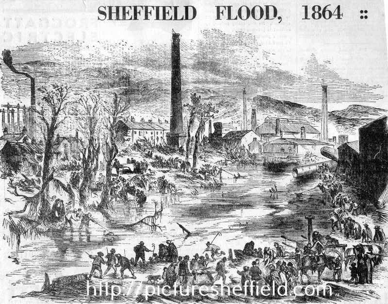
-
Morton Wheel, Philadelphia Works & Bacon Island (Isle) Morton Wheel is recorded in the earliest surviving Norfolk rentals in 1581, but let as north and south ends, which usually suggests 2 halves of one structure. Robert Hobson rented the south end for 20/- and Hugh Attwell the north. 1604, the tenants: Ellis Younge & Robert Shawe paying £4/20/- 1637 Harrison Survey: Thomas Wright, James and Robert Creswicke and William Walton renting 'one half of Morton Wheel' with Robert Sorsby, George Hobson and Edward Creswick the other half. List of Wheels 1641: The two Creswickes, Walton and Matthew Webster rented, 'one cutler wheel called Morton Wheel' for £ 7/10/- Sorsbie, Hobson and Edward Creswicke the same amount for 'the other Morton Wheel' suggesting there were two wheels; not until the middle of the c18th were two separate sites are identified. The Creswickes continued to lease until 1720s. Two groups of tenants took a 21year lease 1666. The Norfolk Estate woodward accounts records repairs in 1676 1716, Leases to cutlers and scissor smiths include Samuel Creswick. An inventory for George Greaves, scissor smith dated 1739 lists. 'goods, working tools, 4 grinding stones, 4 caulks valued at 15/-; 4 glazers; 9 pulleys, 2 horsings, 4 axle trees, a wheel band, a wheel kitt and trough value £2/10/- and 'the goodwill of one original grinding trow at Morton Wheel' £70. Another source; 1760 Rate Assessment reveals: the lease of 1738 instead of the tenant, the landlord paid Land Tax, Poor Rate & Highway Assessment. In 1759 Bradshaw, Overseer of the Poor wanted to double the rate, when the Norfolk Estate refused, he distrained goods at the wheels, the tenants of which then had grounds for 'action of trespass' as none of the 'goods' belonged to the Estate. The document listing the stones removed identifies 'first; second; third and Nether Wheel.' 1739 rentals, records 'New Wheel' which is probably refers to the now named Nether Wheel. 1789 Lease separates "Upper & Lower" Wheels. 1794 recorded separately, with 41 troughs at Upper and 16 at Lower, Samuel Smith working them both. 1800 Nether Hallam Rate Book, Smith recorded for the first time. Land of Samuel Ashton & Co. and George Sybray, at Morton Wheel, [Penistone Road] 1794. https://www.picturesheffield.com/frontend.php?keywords=Ref_No_increment;EQUALS;arc03682&pos=5&action=zoom&id=99253 Map of two parcels of ground near to the Morton Wheel. 1795. Ground between Penistone Road and the Morton Wheels Dam. Yardage and owners given. https://www.picturesheffield.com/frontend.php?keywords=Ref_No_increment;EQUALS;arc02714&pos=4&action=zoom&id=91681 1801 Smith, Hoole & Co., were working 87 troughs. 1807 Norfolk Estate sold the Wheels; over 30 years shares changed hands several times; by 1814 named Philadelphia Works, main partners being Parkin & Hounsfield after 1828 the Butchers; 1844 William & Samuel Butcher alone. 1850 and 1865 Rate Books record a steam corn mill and a tilt forge in part of the works;. indications that Water Power no longer used as no head and fall recorded. The other part, water power still available for the tilt forge and rolling mill. Water power still available 1874 & 1901, William Bury & Co. in occupation at the forge & rolling mill with engine house included with the head and fall still recorded. Little to be seen of the site apart from the Weir and shuttle into the former head-goit. Upper Dam was built over, no buildings remain. Tail-goit which also took water from the lower wheel also built over. Head goit of Nether Wheel not shown on 1892 OS map, nothing remains of the dam either. Buildings and overflow from the dam to the river shown up to 1843 maps have also disappeared. Information from: Water Power on the Sheffield Rivers, edited by David Crossley with Jean Cass, Neville Flavell & Colin Turner. Shown on this Plan of part of the townships of Sheffield and Nether Hallam which is in dispute. 1826. https://www.picturesheffield.com/frontend.php?keywords=Ref_No_increment;EQUALS;arc03896&pos=3&action=zoom&id=97354 The ground concerned includes Upperthorp [Upperthorpe], Port Mahon, Nether Thorp [Netherthorpe] and the land between White House Lane (Infirmary Road) and Morton Wheels. Includes John Addy's house, Lidgate Field, Shales Moor Close, White House Lane or Walkley Road, Penistone Turnpike Road, old road from Owlerton to Sheffield, Green Lane, Cleakham [Cleakham Inn], Morton Wheel and Morton Wheel Dam, River Dun and Bacon's Island, Waterworks, Poor House, Bellefield House, Daniel Hill, Infirmary, Philadelphia, West Dun, Barracks (old Cavalry), Bowling Green, a Tavern [possibly the Cambridge public house], St Philips Church, Globe Works, Roscoe Place, Hoyle Street, Dun Street, Moor Fields, Green Lane, etc. Ordnance Survey Map, sheet no. Yorkshire No. 294.3.25. 1889. Philadelphia Works bottom left. https://www.picturesheffield.com/frontend.php?keywords=Ref_No_increment;EQUALS;q00037&pos=8&action=zoom&id=103541