
Search the Community
Showing results for 'coal pit lane'.
-

Old Sheffield tram routes - bit of confusion !
Lemmy117 replied to Roger Stevenson's topic in Sheffield History Chat
As above, there was a plan to have a route over Psalter Lane, in fact a junction was installed at the Ecclesall Road for a few years. There were also electricity feeder cables for the tramway that didn't necessarily follow the actual route, this could be one forming part of a link between Ecclesall Road and Nether Edge. -

Old Sheffield tram routes - bit of confusion !
Edmund replied to Roger Stevenson's topic in Sheffield History Chat
The Sheffield Corporation Act of 1900 gave powers for a number of tram routes to be constructed, some of which were never followed up. One of these was the route from the junction of Cemetery Road and Washington Road, along the upper part of Cemetery Road and Psalter Lane to Banner Cross, with a link along Cowlishaw Road and Junction Road to Hunters Bar. Discussion of this progressed as far as a proposal in May 1900 to pave Cemetery Road in granite when the tram lines from Washington Road to Sharrow Head were laid. During 1908 Psalter Lane residents held meetings against the proposed extension, they said that the existing Ecclesall and Nether Edge services were adequate and that Psalter Lane was the only main route out of Sheffield unspoiled by tramcars. There were calls in council meetings to veto the extension, for which authorisation had been renewed in a 1907 Act, and in 1909 the plan for this extension was abandoned. By then the Corporation were trialling motor buses for new routes, for which they had received the authorisation in 1907 . The electricity supply system was initially shaped by the huge requirements of the tramways. In 1902 the Sheaf Street power station was changed over to 50Hz generation, more suitable for lighting. In 1904 the Neepsend power station came into use. -
Old Sheffield tram routes - bit of confusion !
Viners replied to Roger Stevenson's topic in Sheffield History Chat
Just had a look at some of the old route maps and posts on the subject and saw mentions of routes being changed and extended. There's a reference to there once being an 'Ecclesall terminus' and the route being extended 'to Millhouses Lane'. Perhaps the answer is the trams did go that way at one time but they re-routed it as the network was extended? If the maps tend to show the final layout of the system, it might not show how it changed over time? https://www.mediastorehouse.co.uk/sheffield-city-archives/maps-plans/sheffield-corporation-tramways-parks-14050142.html -
Old Sheffield tram routes - bit of confusion !
Roger Stevenson posted a topic in Sheffield History Chat
Out walking yesterday ( Tues 20 Feb ) I noticed in the footpath on Cemetery Road at Sharrow Head, the junction of Psalter Lane and Sharrow Vale Road, the service box shown in the attached photo. as far as I am aware and I have just looked at a map of the old tram network on the web, the trams didn't run up Cemetery Road to the top, but turned at the Washington Road junction to proceed to Nether Edge. What's the reason for that box outside 309 Cemetery Road ? I'm intrigued, may be a straightforward answer.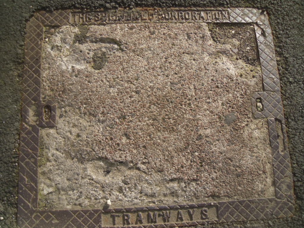
-
Lancasterian Special School Shalesmoor and Wales Court
Ponytail replied to winter64's topic in Sheffield History Chat
Moorfields. Plan of the ground between Green Lane and Gibraltar. 1824. By John Leather, land surveyor. https://www.picturesheffield.com/frontend.php?keywords=Ref_No_increment;EQUALS;arc04168&pos=105&action=zoom&id=104372 Shows: Green Lane, Dun Street, New Street [Dun Fields or Acorn Street], Ebenezer Square, Ebenezer Chapel, Bowling Green Street, Hunters Lane, Ebenezer Street, Spring Street, Cotton Mill Walk, Lancastrian School Gibraltar, Chapel Street, Moor Fields [Moorfields], school, Allen Street, Holmes Lane. Owners / tenants marked: Abraham Ibbotson, Thomas Cornshaw, James Parkinson, Richard Holmes, John Brown, James Jenkinson, Richard Holmes, and Joshua Fowler. The property where Lancastrian School is shown on 1824 Map is No. 56, John Hinchliff on the 1782 Map. The Earl of Surrey’s tenements in Long Croft, Gibraltar [Street] and Bower Springs 1782. https://www.picturesheffield.com/frontend.php?keywords=Ref_No_increment;EQUALS;arc04123&pos=100&action=zoom&id=103838 The names of a later date have been added by Josiah Fairbank, and the line of Russell Street and Green Lane, and Bowling Green Street, added. Kelham Wheel marked. List of tenants given: John Anderton, - Lenthwaite, Hannah Patten, John Hughes, Joseph Broomhead, William Thompson, Robert Owen, Robert Milnes, John Stacey, Charles Kelk, Widow Jewel / William Jewet, Joshua Jackson, John Tricket, John Henfrey, John Ashwell, John Brownell, George Goodlad, John Ellis, Ruth Brewster, George Dyson, Joseph Dyson, Widow Jackson, Thomas Francis, Joseph Yeadon, Mary Yeadon, John Brownell, William Fowler, Benjamin Wood, Josh. Staniland, Jon. Wilde, Mary Yeadon, Thomas Kippax, Thomas Pinder, Thomas Pindar, Ellis Morton, Godfrey Rowley, William Bradshaw, Robert Dore, Stephen Gibson, Matthew Ingram, William Simpson, Overseers of Sheffield Poor, The Town of Sheffield, Joseph Ashforth, John Ibberson, John Goodall, Charles Stewardson, Charles Townsend, George Wilkinson, Elizabeth Holden, Joseph Swan, Thomas Bell, John Parkin, John Taylor, John Hinchcliff, John Brownell, William - , Jonn. Wa-, John Read, Joseph Bower. Gibraltar Street - draft of the widening scheme, 1837 https://www.picturesheffield.com/frontend.php?keywords=Ref_No_increment;EQUALS;arc04122&pos=84&action=zoom&id=103833 Marked: Bowling Green Street; Lancastrian School; Gibraltar Street; Trinity Street; Copper Street; Cupola Lane; Bower Spring; Furnace Hill; West Bar Green. If this is looking towards Gibraltar Street then the old Lancastrian School could be featured on the left. Drinking Fountain at the junction of Shalesmoor/ Gibraltar Street/ Allen Street and Bowling Green Street, looking towards businesses including Thomas Nixon and son, pawnbroker, Gibraltar Street. s19331 A clearer image, but is it the old Lancastrian School? Gibraltar Street from the junction with Trinity Street (right) showing businesses including No. 220/4 Thomas Nixon and Son, pawnbrokers, Midland Railway Co., parcels receiving office and Nos. 204/6 The Oriental Tea Co., Nichols and Co. s16240
-
The Workhouse, the Story of an Institution. Sheffield West Riding of Yorkshire. https://www.workhouses.org.uk/Sheffield/ Building lots between West Bar Green and Silver Street, 1794. https://www.picturesheffield.com/frontend.php?keywords=Ref_No_increment;EQUALS;arc04288&pos=825&action=zoom&id=105975 Marked: Sheffield Workhouse. Jane Taylor, William Wright, George Smith, Joseph Eyre, James Goulden, William Smith, Butcher, George Sybray, Matthew Walton, William Smith, and John Furniss. Town land, extending from Broad Lane End to West Bar, 1778. https://www.picturesheffield.com/frontend.php?keywords=Ref_No_increment;EQUALS;arc04287&pos=824&action=zoom&id=105972 The plan has notes made in 1784. Marked: Broad Lane End, Hollis Croft, Rotten Row, West Bar Green, Pea Croft, White Croft, Hawley Croft, Gregory Row, Silver Street, Hick Stile Field, Queen Street, Workhouse Croft, and Workhouse. George Hounsfield, Samuel Radford, John Birks, George Allen, George Oates, John Haywood, Hollis Hospital land, Thomas Wilkinson, Josh. Bower of Hollis Hospital, Martha Hill, John Foster, William Thornton, John Thompson, Matthew Lambert, John Goodwin, Ebenezer Wall, George Greaves, Thomas Radford, Joseph Hepworth, Mary Cowley, Samuel Crook, Widow Bradshaw, George Pears, John Holberry?, Catherine Dixon, Mark Skeltens?, John Hobson, Stephen Green, John and George Wild, [?] Green, The Overseers of the Poor in the Township of Ecclesfield, Ecclesfield Workhouse [tenants of this parcel of land], John Longden, Mary Pearson, John Darwin and Co., and Samuel Marshall. Ground Plan for the intended workhouse for Sheffield, between Broad lane and Trippett Lane, c.1791. https://www.picturesheffield.com/frontend.php?keywords=Ref_No_increment;EQUALS;arc01856&pos=268&action=zoom&id=71281 Brew house, wash house, coal house, bake house, wood store, flour store, men and boys work rooms, women and girls work rooms, dining room, boiling house, kitchen, pantry, courts and yards, matrons room, matrons store room, governor’s room, governors store room, committee room, school room, operation room, doctors shop, doctors parlour, coal store, cottages for respectable paupers and married couples and croft or garden. Plan of a proposed Workhouse for Sheffield, between Broad Lane and Trippett Lane, c.1791. https://www.picturesheffield.com/frontend.php?keywords=Ref_No_increment;EQUALS;arc01855&pos=267&action=zoom&id=71280 Shows: Work rooms, store room, dining room, laundry, brew house, kitchen, boiling house, bakehouse, oven, pantry, bread room, matrons room, store room, governors room, overseer room, doctors rooms, taylors room, poor attending on overseers [room], sick poor [rooms], bath, cells, etc. Chamber Attic Storeys for the intended Workhouse for Sheffield, between Broad Lane and Trippet Lane, c.1791. https://www.picturesheffield.com/frontend.php?keywords=Ref_No_increment;EQUALS;arc01857&pos=19&action=zoom&id=71282 Shows: Bedrooms, laundry room, porters lodging room, paupers sent for passes room, cottages for respectable paupers and married couples. Notice of Resolutions made at a General Meeting of the Inhabitants of the Township of Sheffield ... for the purpose of taking into consideration the present state of the workhouse and the best means of improving the same. 1804. Rev. James Wilkinson in the chair. https://www.picturesheffield.com/frontend.php?keywords=Ref_No_increment;EQUALS;y09967&pos=5&action=zoom&id=65482
-
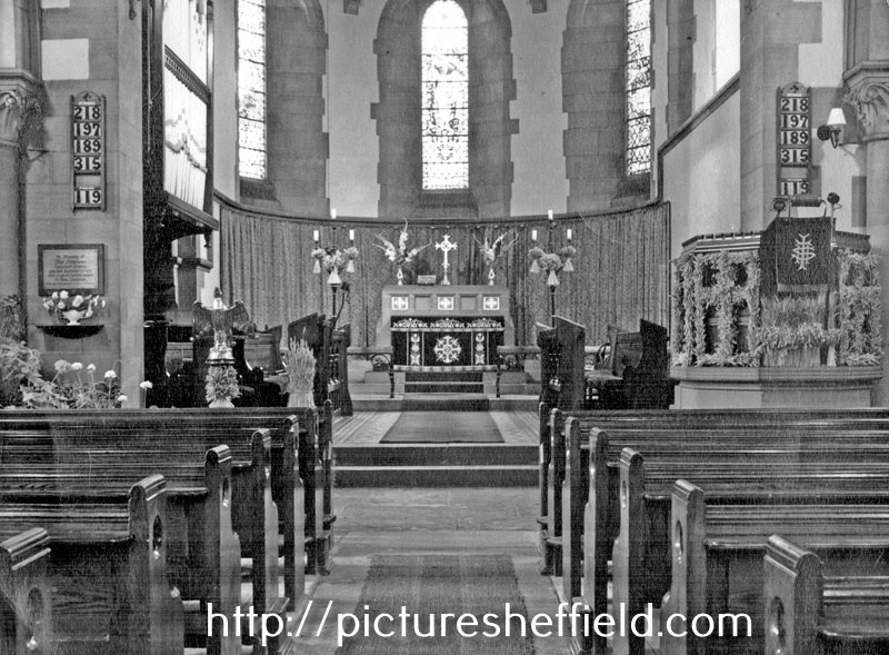
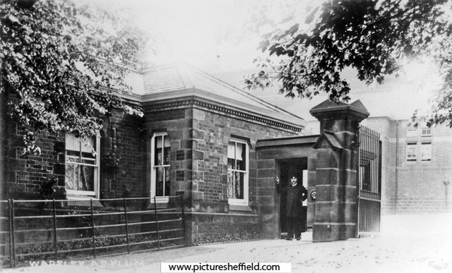
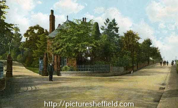
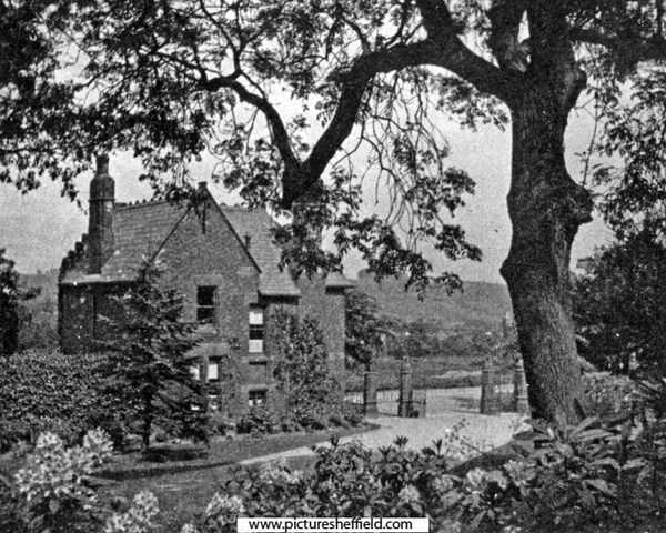
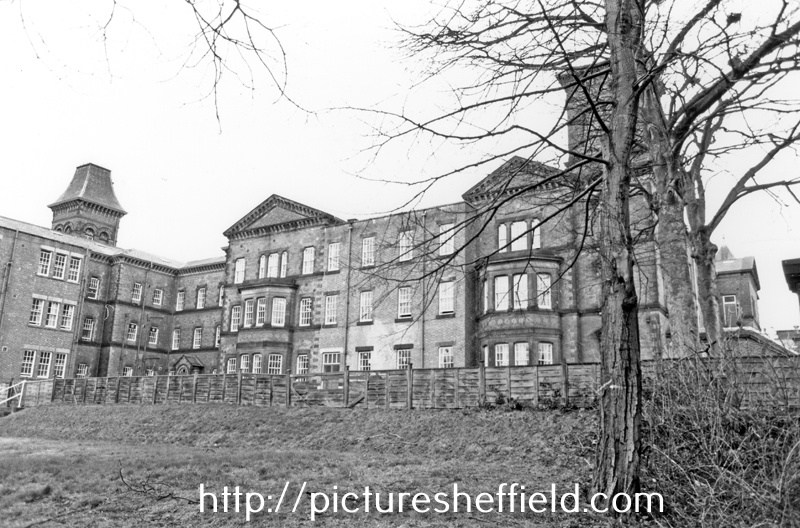
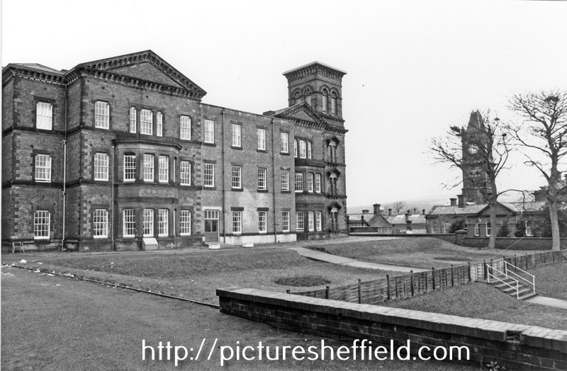
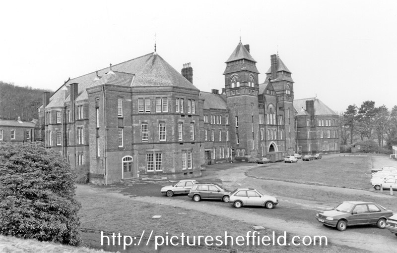
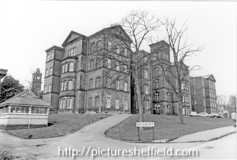
Built in 1872 as South Yorkshire Asylum; 1889-1929 The West Riding Asylum, Wadsley; Converted Spring 1915 into Wharncliffe War Hospital; 1930-1948 known as Wadsley Mental Hospital; 1948-1959 Middlewood (Mental) Hospital; 1959-1972 Middlewood (Psychiatric) Hospital. For more information see: Middlewood Hospital 1872-1972, Thorpe. Local Studies Ref: 362. 209 S. South Yorkshire Asylum - Plan of Estate. https://www.picturesheffield.com/frontend.php?keywords=Ref_No_increment;EQUALS;arc01407&pos=7&action=zoom&id=65677 Shows: Hospital Buildings, including Female and Male Wings, Administrative Block, Nurses' Residence, Laundry House and Dining Hall, as well as Airing Courts, Drying Green, Boiler buildings, Wood and Masons' Yards, Farmery, Kitchen Gardens, Isolation Hospitals (2), Church, Nursery, Gardener's Lodge and Entrance Lodge. The extent of the estate shown is bounded by irrigation land and the River Don to the north north east, Worrall Lane to the west south west, land belonging to Elijah Eaton and Mr. Newton to the north, and land belonging to Messrs. Brooke and Sons, the Trustees of George Miller, and Mr. Fowler to the south. Whilst the date of the plan is unclear, the layout of the buildings shown correspond to a period covering approximately 1889-1901. The name West Riding Asylum was used between 1889 and 1929, and it is known that a second dining hall for women, adjacent to the female detached block, was built in 1901. This hall is not shown on the plan. Printed by Pawson and Brailsford, Sheffield. Scale: 1 inch : 22 yards. Four sections pasted together. Original at Sheffield City Archives X71/2/1. Asylum Entrance Gates & Middlewood Road. t08535 The Gate, looking towards Middlewood Road. s05403 Asylum Lodge. s05404 Kingswood Block, Wards 9 - 13, February 1990.s23410 Queenswood Block Wards 25-28 with Clock Tower Administration Block in the background. February 1990.s23414 South Yorkshire Asylum, Wadsley Park- Basement Plan. Feb. 1875. https://www.picturesheffield.com/frontend.php?keywords=Ref_No_increment;EQUALS;arc07350&pos=179&action=zoom&id=106493 Marked: tailor's shop, shoemaker's shop, attendant's rooms, scullery, wc, shoe rooms, dormitories, single room, day room, ashes, coal, lavatory, bath room, dressing rooms, etc. South Yorkshire Asylum - Workshops (boilerhouse, Bakehouse, Brewhouse, Weaving Shed etc.) Plan and Section. 7th Jan. 1871. Architect: Bernard Hartley. https://www.picturesheffield.com/frontend.php?keywords=Ref_No_increment;EQUALS;arc07351&pos=177&action=zoom&id=106489 Marked: smith's shops, boiler house (with boilers), bake house (with ovens), brew house, plumber, weaving shed, joiner's shop, bread store, malt [store], painter, yard, carpenters' shop, timber yard, urinals; bookbinder, upholsterer, hair picking room, mason's shed and old metal [store]. South Yorkshire Asylum - Washhouse, Laundry, etc., Plan and Sections, c.1871. https://www.picturesheffield.com/frontend.php?keywords=Ref_No_increment;EQUALS;arc07352&pos=178&action=zoom&id=106491 Marked: laundry, yard, drying closet, wringing machines, troughs for hand washing, washing wheel, copper, stock for rough clothes, rinser of galvanised iron, W.C.s and urinals, engine, bevel wheels, stone heeping pits, ironing stove, cold air flue, sorting and folding room, office, women's distribution room, hot water cistern proposed over engine house, women's lobby, women's receiving room, men's distribution room, men's lobby, men's receiving room. South Yorkshire Asylum - Laundry Residence Ground Plan, 1884. https://www.picturesheffield.com/frontend.php?keywords=Ref_No_increment;EQUALS;arc07353&pos=181&action=zoom&id=106546 Marked: day room, scullery, kitchen, W.C.s, nurse, buckets, single rooms, dormitory, bath room, dressing room, etc. South Yorkshire Asylum - Laundry Residence Chamber Plan, 1884. https://www.picturesheffield.com/frontend.php?keywords=Ref_No_increment;EQUALS;arc07354&pos=180&action=zoom&id=106541 Marked: dormitory, stores, W.C.s, nurse, single rooms, bed room, and single rooms. South Yorshire Asylum - Male Block, Second Floor, c.1908. https://www.picturesheffield.com/frontend.php?keywords=Ref_No_increment;EQUALS;arc01414&pos=170&action=zoom&id=66496 Proposed Adaptation of Recreation Hall for Cinematograph Entertainments. 1924. https://www.picturesheffield.com/frontend.php?keywords=Ref_No_increment;EQUALS;arc01413&pos=58&action=zoom&id=66495 Proposed Hospital for Tuberculosis Patients. 1925. https://www.picturesheffield.com/frontend.php?keywords=Ref_No_increment;EQUALS;arc01415&pos=59&action=zoom&id=66497 Sanitary Accommodation for Ward 23. 1925 https://www.picturesheffield.com/frontend.php?keywords=Ref_No_increment;EQUALS;arc01410&pos=55&action=zoom&id=65680 Southwood Block Wards 14-24, February 1990.s23409 Ward and Proposed Solarium. Ground Plan & Elevations. 1926 https://www.picturesheffield.com/frontend.php?keywords=Ref_No_increment;EQUALS;arc01419&pos=63&action=zoom&id=66502 Proposed Solarium marked on Estate Plan. 1925. https://www.picturesheffield.com/frontend.php?keywords=Ref_No_increment;EQUALS;arc01412&pos=57&action=zoom&id=66494 Northwood Block, Wards 5 - 8, February 1990. s23413 South Yorkshire Asylum Church Ground Floor Plan showing dimensions and layout of pews to accommodate 631 people. 1873. https://www.picturesheffield.com/frontend.php?keywords=Ref_No_increment;EQUALS;arc01853&pos=175&action=zoom&id=3264 The Asylum Churcht06703 u01197
-
The Cotton Mill replaced an earlier Silk Mill of about 1760 which burned down 1792. After a fire in 1828 the Cotton Mill was converted to Sheffield Workhouse, part of which was utilised as a hospital for the Cholera epidemic 1832 and Sheffield Flood of 1864. William Bower leased the former named Kelham Wheel, building a Silk Mill sited to the south east of the original wheel, taking water through a secondary channel diverging from Kelham head race. Featured on 1771 Town Map of Fairbank and in more detail drawn to accompany the lease of 1773. Only functioning briefly, as Bower was declared bankrupt 1774. Plan of the ground and tenements about the junction of Spring Croft, Bower Spring Lane and the road from the Silk Mill. Surveyor: William Fairbank II. 1783. https://www.picturesheffield.com/frontend.php?keywords=Ref_No_increment;EQUALS;arc03040&pos=1&action=zoom&id=96210 A small lot between Spring Croft and the proposed Back Lane (Love Lane) 1774 the Silk Mill was converted to a Cotton Mill when Wells, Heathfield & Co. took a 21 year lease. Built on either side of the secondary race, incorporating the abandoned cutlers wheel. A valuation survey describes a water wheel 19ft diameter and 21ft wide, producing power adequate enough for 70 cutlers troughs. Fire damaged in 1792 and running again by 1794. The map of 1805 is the rebuilt second mill. Spring Street. Colson Crofts measured for the Duke of Norfolk, including the Cotton Mill, the Steam Engine Grinding Wheel, and T Holy’s land laid out in streets. 1805. https://www.picturesheffield.com/frontend.php?keywords=Ref_No_increment;EQUALS;arc04089&pos=19&action=zoom&id=103413 Shows: Cotton Mill Co., goight to footbridge, Cotton Street, Bower Street, north side of an ancient cut of fish pond, Spring Street, Water Street, Pear Street, Plum Street, Love Street, Engine Street (changed to Steam Street) and steam engine grinding wheels. The Cotton Mill was operated by Water Power until after another fire August 1810 when steam power was introduced. The freehold was sold in 1815, showing there were two Cotton Mills, the steam powered one the Silk Mill site (becoming the Workhouse in 1828) and a smaller water powered mill, converted from the Kelham grinding wheel, also housing a 20hp. Boulton & Watt steam engine. Kelham Wheel reverted to being a grinding wheel. For more information about Kelham Wheel see: "Water Power on the Sheffield Rivers" edited by David Crossley with Jean Cass, Neville Flavell & Colin Turner. Kelham Street. The Cotton Factory, the Cotton Mill (formerly Kelham Wheel) etc. in lots for sale, 1815. https://www.picturesheffield.com/frontend.php?keywords=Ref_No_increment;EQUALS;arc04087&pos=18&action=zoom&id=103381 Shows: Spring Street, Bower Street and Spinning Street. Also marked: engine, boiler, cotton mill (formerly Kelham Wheel), store, wash, nine dwelling houses, large cotton factory, palisades, counting house, two dwelling houses, kitchen, roller shop, iron turners shop, tinner’s shop, turners shop, millwright’s shop, shed, intended engine, gearing room, engine house, intended boiler, boilers, blowing room, warehouses with picking rooms over them, four houses, ten houses. Former offices of Ibbotson Brothers and Co. Ltd., merchants and manufacturers, Globe Steel Works, Alma Street at junction with Cotton Street. 1986. t01080 William Ibbotson founder of Ibbotson Brothers, steel converters, refiners, manufacturers and worldwide merchants built the aptly named Globe Works (Penistone Road) in 1824. The main building was designed to incorporate a domestic residence. The west wing was residential, the east wing counting houses and warehouses. In 1863 he moved to a site on Cross Smithfield before purchasing the former workhouse on Alma Street which he renamed Globe Steel Works. For more information see: Globe Works by Kim Streets (Sheffield Museums), August 1990. Local Studies Ref: 2867 MP. Cotton Mill Walk off Alma Street. 28th April 2007. https://www.picturesheffield.com/frontend.php?keywords=Ref_No_increment;EQUALS;t03223&pos=4&action=zoom&id=33903 Cotton Mill Walk off Alma Street runs down the side of the Fat Cat public house, formerly The Alma. The original cobbled walkway is still visible (2007) and it turns to the right just before the building in the photograph opening up into what would have been the Court which is now a car park for Kelham Island Industrial Museum. Cotton Mill Walk, from the Court entrance looking towards Alma Street with the Fat Cat public house left and the Globe Steel Works in the background. 28th April 2007. https://www.picturesheffield.com/frontend.php?keywords=Ref_No_increment;EQUALS;t03222&pos=3&action=zoom&id=33899 Cotton Mill Row from Alma Street looking towards Bower Street. 1st August 1985. s25356 Cotton Mill Walk https://sheffielder.net/tag/cottonmill-walk/ Hallamshire Historic Buildings. Remains of Sheffield’s first workhouse and only cotton mill – Cotton Street and 24 Alma Street 22/01020/FUL https://www.hhbs.org.uk/2023/01/28/remains-of-sheffields-first-workhouse-and-only-cotton-mill-cotton-street-and-24-alma-street-22-01020-ful/ Sheffield Wire. Plans to convert Kelham Island cotton mill are destroying the historic character of Sheffield, by Oliver Nunn, Feb 20, 2023 https://sheffieldwire.co.uk/index.php/2023/02/20/plans-to-convert-kelham-island-cotton-mill-are-destroying-the-historic-character-of-sheffield/
-
Oughtibridge Hall Farm, Oughtibridge Lane, in the Chapelry of Bradfield
Ponytail posted a topic in Sheffield History Chat
Oughtibridge Hall Farm, c.1910. t05322 Dates from the 16th century Plan of Oughtibridge Hall Farm, in the Chapelry of Bradfield [and] the property of the Duke of Norfolk, 1770. https://www.picturesheffield.com/frontend.php?keywords=Ref_No_increment;EQUALS;arc04453&pos=21&action=zoom&id=152230 Marked Wharncliff [Wharncliffe] Wood, The Countess of Bute's land, the Duke of Norfolk's land, common, River Don, Slitting Mill weyre [weir], breach [in the river bank], forge weyre [weir], Oughtibridge [bridge], orchard, gardens, Little Hollings Wood, Far Hollings Wood, Prior Wood, footways, Oughtibridge Lane, Stony Bank Spring, Beeley Wood, Wilson Spring, [?Lyster's] Land, Dungworth's land. Fields numbered, but no list. Neatly coloured. Small cartouche. Plan extends from the River Dun (Don) in the south west to Oughtibridge Lane. Oughtibridge Hall and Outbuildings Grade II Listed. https://historicengland.org.uk/images-books/photos/item/IOE01/01854/35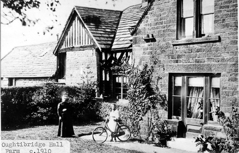
-
Sheffield United Football and Cricket Club Ltd., Bramall Lane. - Ground Plan Showing Proposed New Terracing etc. 1901. Architect: Archibald Leitch (1866-1939) 40 St Enoch Square, Glasgow. https://www.picturesheffield.com/frontend.php?keywords=Ref_No_increment;EQUALS;arc02022&pos=2&action=zoom&id=73831 Sheffield United Cricket and Football Club Ltd., Plans and a Elevations of new Terracing.1901. https://www.picturesheffield.com/frontend.php?keywords=Ref_No_increment;EQUALS;arc02023&pos=3&action=zoom&id=74837 Sheffield United Cricket and Football Club Ltd., Seated Terracing next to Pavilion. https://www.picturesheffield.com/frontend.php?keywords=Ref_No_increment;EQUALS;arc02025&pos=5&action=zoom&id=74839 New Seated Terracing next to Pavilion. https://www.picturesheffield.com/frontend.php?keywords=Ref_No_increment;EQUALS;arc02024&pos=4&action=zoom&id=74838 Sheffield United Cricket and Football Club Ltd., Bramall Lane, Sheffield - New Grandstand, amended plan of drainage. Architect: Archibald Leitch (1866-1939) 40 St Enoch Square, Glasgow. https://www.picturesheffield.com/frontend.php?keywords=Ref_No_increment;EQUALS;arc02026&pos=6&action=zoom&id=74840
-
Booth & Co., Park Iron Works, Brightside Forge & Royds Mill.
Ponytail replied to Ponytail's topic in Made In Sheffield
Plan of Salmon Pastures held of the Duke of Norfolk by Thos. Sambourne. 1792. Surveyor: William Fairbank II. https://www.picturesheffield.com/frontend.php?keywords=Ref_No_increment;EQUALS;arc02669&pos=7&action=zoom&id=91474 Shows part of the River Don, and the Goight and Foundry; (Warren Street, Royds Mill and Farm.) fields etc. lettered and listed with particulars: a. Proposed to be taken on lease for 99 years. b. Proposed to be given up to the Road. c. Lower Salmon Pastures, as proposed to be altered. d. Held by Booth & Co., part of the Netherfield. e. Island. f. Upper Salmon Pastures. g. Lower part. h. Upper part, proposed to be kept for sand. Held by John Booth & Co. A map of Salmon Pastures held of the Duke of Norfolk by Wm. and Geo. Binks.1787. Surveyor: William Fairbank II. https://www.picturesheffield.com/frontend.php?keywords=Ref_No_increment;EQUALS;arc02667&pos=5&action=zoom&id=91471 Between (Warren Street) and the goight and the Don; closes, etc., numbered and listed with particulars. Includes the Nether Field and the old wheel; numerical list with acreages; field names given on the map. (Royds Mill and Farm.) It's probable that Burton took over the Mill before 1720. 1718/19, Burton Dam appears in the Repair account. 1737 William Burton took a 21 year lease of "corn mill called Attercliffe Mill near Washford Bridge" 1756 lease still in the name of Burton, 1761 the property listed in his will. 1765, Hartop, ironmasters had a 21year lease; 1782, Binks, Booth and Hartop, the lease recording the poor condition of Royds Mill and Wheel and measures needed by the new tenants to rebuild it and improve the water supply. 1794, Booth & Co. recorded at Royds Mill & Wheel. The partnership were at this time on the south side of the River Don, developing the Park Ironworks. 1821, Royds Works advertised for sale or let by Auction described as a Corn Mill; Forge and Rolling Mill. A Map of the Turnpike Road from Westforde [Washford] Bridge to the Mill Goite, c.1760-1770. Surveyor: John Needham. https://www.picturesheffield.com/frontend.php?keywords=Ref_No_increment;EQUALS;arc02665&pos=4&action=zoom&id=91373 Outline of the mill wheel and goit; 'measurement of land required to make the road straight.' (Royd's Mill Street) Marked: Mr. Burton Lane. River Dun (Don); Weste Ford Bridge (Washford) (Royds Mill and Farm. Windsor Street.) For more information about Royds Mill and Wheel, see "Water Power on the Sheffield Rivers" , edited by David Crossley with Jean Cass, Neville Flavell & Colin Turner. -
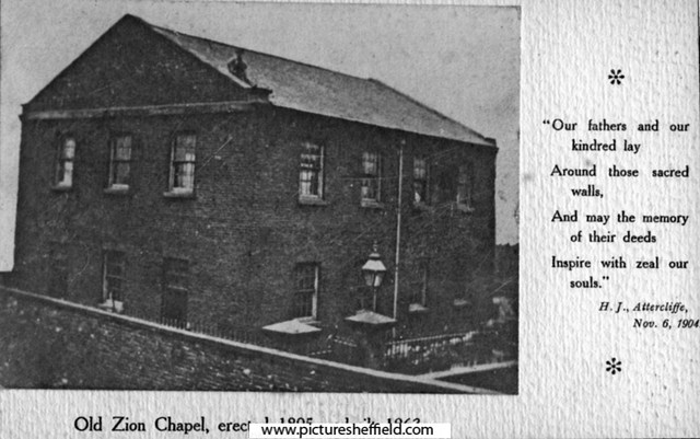
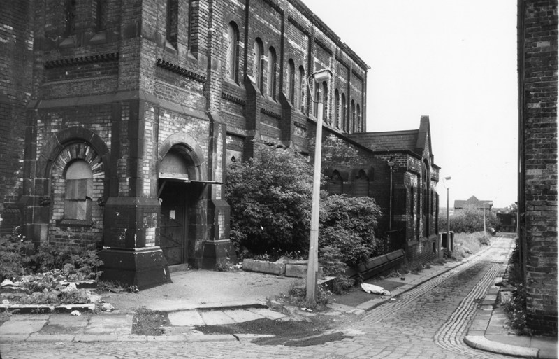
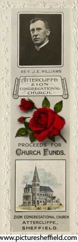
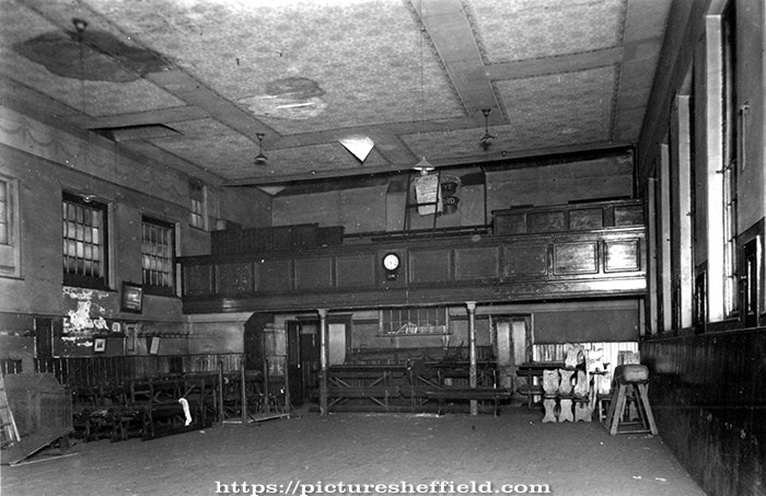
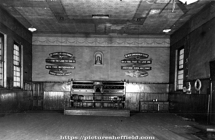
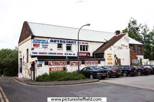
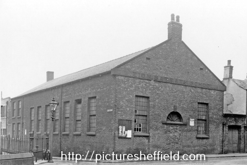
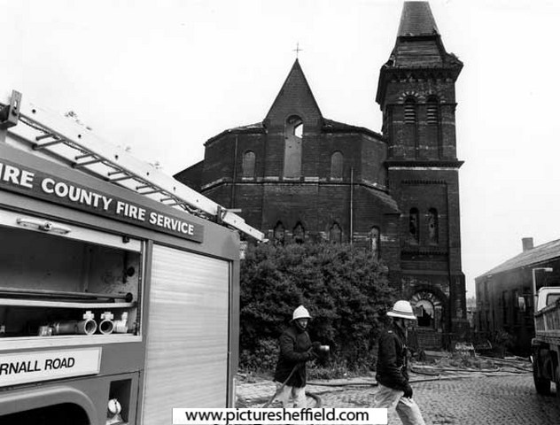
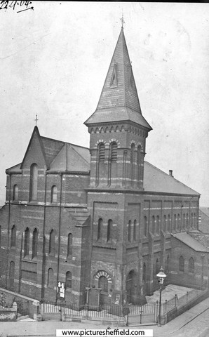
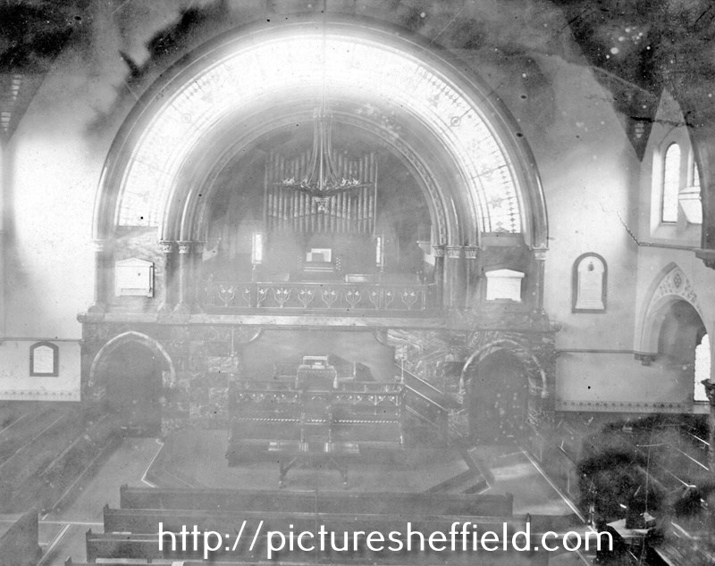
Zion Congregational Church, Zion Lane, Attercliffe
Ponytail posted a topic in Sheffield Churches & Religious Buildings
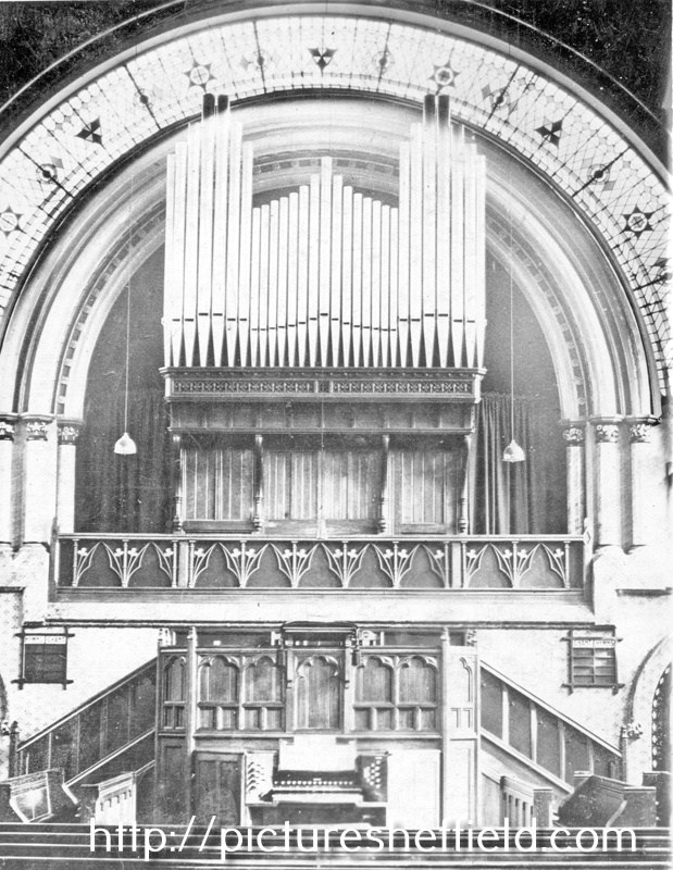
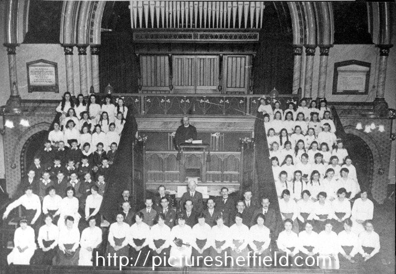
Old Zion Chapel, Zion Lane, Attercliffe erected 1805. s04904 I believe this may be a Plan of the original chapel, can anyone confirm it? David Deakin's leasehold at Attercliffe taken for Calvinist Chapel, 1806. Surveyors: William and Josiah Fairbank. https://www.picturesheffield.com/frontend.php?keywords=Ref_No_increment;EQUALS;arc02674&pos=56&action=zoom&id=91479 Marked: Land held by Robert Deakin; Ground demised to David Deakin. 1806. (another plot) Formerly devised to William R Deakin and William Hutchinson; Turnpike Road from Sheffield to Rotherham. Original chapel opened 1805, new chapel opened 4th February 1863. Zion Congregational Church, Zion Lane, Attercliffe this building opened 4th February 1863. s04902 Zion is a Hebrew word meaning fortress and was the name given to a hill south west of Jerusalem on which lay older and higher part of the Holy City, the portion often referred to as the 'City of David'. The hill served as a fortress. The Zion whose story we seek ... is no hill with a city on it but a chapel hiding down the dingiest street in all Sheffield. Hidden away at the back right off the main street and only approached by the narrowest of lanes As Canon Sydney Smith used to say 'in all my parishes I have never had a finer or more worthy folk than the people of Attercliffe, but the beggars won't come to Church.' Information from: The Gates of Zion by P.G.S. Hopwood Local Studies Ref: 285.8 SST. 22nd September 1904.s04901 Interior of Zion Congregational Church, u04918 Photographer: L. Havenhand, Attercliffe. Organ, Zion Congregational Church. u04917 t04583 Newspaper Cutting under the heading, Praiseworthy Work at Zion Congregational Church, Attercliffe. 30th March 1912. https://www.picturesheffield.com/frontend.php?keywords=Ref_No_increment;EQUALS;u01072&pos=34&action=zoom&id=36799 A practical effort is being made at Zion Congregational Church to relieve some of the distress in the city. The schoolroom has been devoted to the work, and through out the day is thronged by men who are out of work. Dinner and tea were served yesterday to 350 men. (1) Playing dominoes and draughts during the day. (2) The willing kitchen helpers (3) Dinner-time. Zion Congregational Church, Zion Lane looking towards Church Lane. 29th May 1980.s27037 The Sabbath School was probably built 1805-1806.The first Sunday School Anniversary Sermon 25 Jun 1809. Zion Sabbath School, Zion Lane. t03190 Interior of Sabbath School, Zion Lane. t01392 t03191 About 1935/6 Zion Sabbath School became F. Melling Ltd, Chapel Printing Works. Autostart, former Zion Sabbath School, No.10 Zion Lane, Attercliffe. 2013. c04612 Photographer: Alex Ekins. Autostart Sheffield (formerly the Zion Sabbath School), No.10 Zion Lane and junction with Lawrence Street. 2003. https://www.picturesheffield.com/frontend.php?keywords=Ref_No_increment;EQUALS;t10447&pos=9&action=zoom&id=91408 Commemorative book mark sold in aid of church funds showing Rev. J. E. Williams and Attercliffe Zion Congregational Church. y05680 Original at Local Studies MP 4501 S. Fire at Mathews Warehouse (former Zion Congregational Chapel), Zion Lane, Attercliffe. 22nd June 1987.u07048 Photographer: SCC Engineers and Surveyors The church was demolished soon after a fire in 1987. Plan of a plot on Attercliffe Road, bounded by Zion Lane, Church Lane and High Street.1881. https://www.picturesheffield.com/frontend.php?keywords=Ref_No_increment;EQUALS;arc02675&pos=42&action=zoom&id=91514 Marked: Zion Lane; High Street; Church Lane; Attercliffe Church Yard.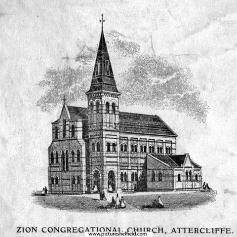
-
History of Attercliffe and the Benjamin Huntsman steelworks
Ponytail replied to a topic in Sheffield History Chat
A Plan of two Closes, Buildings, etc. held under the Duke of Norfolk by Samuel Scholey and W. Scrapper. 1763. https://www.picturesheffield.com/frontend.php?keywords=Ref_No_increment;EQUALS;arc02680&pos=75&action=zoom&id=91520 Surveyor: William Fairbank II. This is one of the enclosed strips south-west of Worksop Road; acreages listed; explanation of the buildings. Marked: Close in Saml Scholey's possesion. Close in W. Rapper's possesion. Included in the next strip: B. Huntsman's Furnace; a. Part of Benjamin Huntsman's Yard; b. A shed erected by him; c. Part of a Mill House built by him; d. A piece of Ground proposed to be taken by him for enlarging his Works; e. g. Buildings; f. a Yard; h. h. i. Gardens, held by William Crapper. k. Another part proposed to be taken by Benjamin Huntsman for enlarging his works. the etc. in the next strip. Also marked: Lands vested in the Capitol Burgesses of Sheffied; Attercliffe Green; (Attercliffe Steel Furnace, Worksop Road, Shirland Lane.) -
Tsavo posted 10th April 2007 Come on Richard, put me out of my misery! Who was it? RichardB posted 10th April 2007. I was sure you were going to get this, you even mentioned the authors name in a posting, saying you hoped for more time now your family had gone back home !!!! At the top of the street, next to the Church Gates, on the site of Pawson and Brailsford's present premises, was the iron- monger's shop of Thomas Heaton, Town Trustee and Church Burgess. When the old Town Hall was built, close to him, in I700, he supplied the "chaines" for the hall candlestick. He was elected a member of the Town Trust in I724. A tombstone in the churchyard records that he died December I9, I734, in the 48th year of his age, and tells us that " He was easy and agreeable in every path of private life, and useful to the publick as a member of the three publick bodies of the Town, the Church, and the Free School, and died generally lamented." Then follow the names of his wife and of a number of their daughters, who long remained in occupation of the High Street premises, ending with " Hellen, the last survivor of this truly Respectable Family, who departed this life, the I8th June, I795." We get an instructive glimpse of the High Street of the past in a reference to Mr. Heaton's property in a document dated I726.* In that year Heaton leased to the Rev. John Balguy " part of his garden adjoining the Boys' Charity School." On this Mr. Balguy built a dwelling-house, and it is evident that Mr. Heaton's garden had extended behind his shop, for the whole length of the churchyard, to the Charity School. Mr. Balguy was at one time a teacher in the Grammar School, where his father had been headmaster from I664 to I696; and mention of him brings us into connection with another High Street worthy and Town Trustee, Mr. Christopher Broomhead, for the Rev. John Balguy married one of Christopher Broomhead's daughters; Mr. Robert Drake, surgeon, another; and Mr. Christopher Robinson, headmaster of the Gran mar School, and the author of various theological books " Local Notes and Queries," Sheffield Indepenednt, March I5, 1877. + Gatty's Hunter's " Hallamshire," pp. 250,255, 308-9. Ante, p. 174. Source : REMINISCENCES OF SHEFFIELD by R. E. LEADER CHAPTER 13 - HIGH STREET and OLD INNS. This is the property of the Heaton's and surrounding. Information from The Story of Sheffield High Street, from 16th Century to Modern Times, by Pat Dallman. "At the beginning of the 1700's the house next to the church gates, which in the previous century has belonged to the Creswick and Joshua Bayes, came into the possession of Joseph Banks, the attorney. He sold it in 1710 to Thomas Heaton, an ironmonger and his shop with its post and chains across the front, became a well known feature of the town centre. Thomas was born in 1686 and married wife Sarah in 1718." They had 7 daughters, one of which, Helen lived there until her death 1795. Advertised for Sale in the Iris 28th August 1795. "Most eligible and advantageous situated in High Street, Sheffield; near the old Church, and consists of two Dwelling Houses with Shops to the front and one other Dwelling House fronting the Church Yard, with several Outbuildings an Appurtenances thereto adjoining and belonging; also a Carriage Road from the uppermost part of the Yard to Campo Lane. The extent of the front to High Street is about 19 yards and fronting the Church near 80 yards." Plan of the tenements and ground belonging to the late E. Heaton (now to John Butcher and John Frith in 1806), extending from the High Street to the Hart's Head, c. 1795 https://www.picturesheffield.com/frontend.php?keywords=Ref_No_increment;EQUALS;arc04144&pos=23&action=zoom&id=103990 Marked: The Hart's Head [Hartshead], John Hoyland's freehold, road common to the Charity School, Samuel Turner, Butcher and Frith, [property of] the trustees of the Charity School / [Dr?] Drake, late John Winter's leasehold, the property of the heirs of Thomas Vennor, High Street, [property] sold to Samuel Turner, [property sold to W. H. Saunders, Town Hall. A plan of the tenements and ground purchased by S Broadbent of W Battie, with a scheme for opening a communication betwixt the High Street and the Hartshead. (not dated.) https://www.picturesheffield.com/frontend.php?keywords=Ref_No_increment;EQUALS;arc04313&pos=25&action=zoom&id=107173 Marked: High Street, Hartshead, brewhouse, property of the late Widow Heaton deceased, Thomas [?] Shaw’s freehold, William Webster’s freehold, John Barlow’s freehold, charity school, and Campo Lane. Part of the property (believed to be The Crown public house) of Thomas Vennor, a draper, made way for York Street in 1770. His drapers shop had bow windows. (Proposed) Plan of a new street along Fig Tree Lane from York Street to West Bar. 1820. https://www.picturesheffield.com/frontend.php?keywords=Ref_No_increment;EQUALS;arc04108&pos=9&action=zoom&id=103671 Note: the suggested improvement was to make a straight wide street of York Street, Figtree Lane and New Street, but it was never carried out. Shows High Street, York Street, Hartshead, Campo Lane, Figtree Lane, Queen Street, Bank Street and West Bar. Also shows Boys Charity School. Names marked: Gunning, W. and G. Foster, John Hoyland, late Joseph Binney, H. Tudor's executors, late Joseph Ward, John Turner, William Cowley, T. C. Burgesses, A. A. Hardy, John Parkes, Ashforth, Widow Pears, Daniel Holy, Sykes, Marchinton, John Fawcett, William Davis, Dyson, Tippet, Mary Seaton, Francis Allwood, and Joseph Fowler.
-
Map of the Estate of Samuel Staniforth in the township of Attercliffe-cum-Darnall. 1832. https://www.picturesheffield.com/frontend.php?keywords=Ref_No_increment;EQUALS;arc03905&pos=103&action=zoom&id=100165 Full title: Map of the Estate of Samuel Staniforth in the township of Attercliffe-cum-Darnall made for the purpose of ascertaining the title to the several parts thereof as far as can now be done and shewing what parts thereof were entailed by the will of John Staniforth deceased dated 11th March 1700. The following are marked: Top left: Pale Side Field, Upper New Close, Partridge Flatts, Little Wood Close, Green Meadow, Bashforth Close, Calf Close, Barber Close, Lower New Piece, Long Close and Great Old Cotes. Bottom left: Goose Dole, The Acre, Park Field, Lock Close, Old Town Flatt, Hanging Bank, Bowden Housestead Wood, Hollinhurst, Pingle, Six Acre or Rodger Close, Black Hedge, Stone Delf, Ash Close, Two Part Field, Hibberd Field, Owler Greave Close, an allotment, Pease Field, Croft, Near Turner Corft, Far Turner Croft, Near Town Field Close, Turners Flatt, Little Close, Stoop Gate Field, Cockers oak, Great Kirk Bridge. Also shows road from Worksop. Top right: Cow Pasture Tongue, Spring Field, Cow Pasture, Dickawood Close, Stacye Field, Straw Mill Close, Nicholson Croft, Little Town Field, an allotment, Darnall to Sheffield Road Bottom right: Makin Croft, Pit Hill Close, Darnall Hall. Plan of a Freehold Estate at or near Darnal [Darnall] purchased by Samuel Staniforth of Ibbotson Walker. 1839. https://www.picturesheffield.com/frontend.php?keywords=Ref_No_increment;EQUALS;arc03940&pos=10&action=zoom&id=101830 Includes: Little Park Field, Great Park Field or Three Part Field, Green Lane, New Close, Owler Greave Close or Please Land Close, Lock Close, Long Close, Broom Close or Hanging Bank, Far Ley Lands, Near Ley Lands, Broom Close or Hanging Bank, Winter Croft. Land owners include: Church Burgesses and William Deakin. Surveyor: J. Fairbank and Son. Made from the survey made at the time of the Inclosure. The following map fills in some of the gaps on Staniforths map dated 1832. A Map of an Estate in Darnall in the Parish of Sheffield, the property of John Smelter. 1813. https://www.picturesheffield.com/frontend.php?keywords=Ref_No_increment;EQUALS;arc03936&pos=11&action=zoom&id=101852 Includes reference to: Acres Hill Close, Stone Delves, Hollinhurst, Pellet Sick, Bottoms, Footway Field, Rough Close, Little Old Cotes, Horse Pasture, The Acre, Croft, Barn, Stables, stackyard and garden, houses and gardens, allotment on Owler Greave. Samuel Staniforth is mentioned several times as a landowner.
-
Storthfield, Storth Lane/ 237 Graham Road now Ranmoor House
Ponytail posted a topic in Sheffield History Chat
T. W. Sorby, Esquire - "Storthfield," Storth Lane (renamed Graham Road) Trade Directory of 1905, Thomas William Sorby lived at Storthfield, No. 237 Graham Road of Thomas Sorby & Sons, iron merchants, steel convertors and importers of Swedish Iron & Steel, Mowbray Street. 1879 Directory, Thomas William Sorby, (Thomas Sorby & Sons) 269 Western Bank. Thomas & Sons, steel manufacturers, English & foreign iron merchants (and Swedish iron merchants) Boro Steel Works, Mowbray Street. The following Plans of "Storforth" by Architects, (plans before 1901) Flockton Gibbs & Flockton, (after) Gibbs & Flockton, 15 St. James Row. Also names building etc. contractors. T. W. Sorby, Esquire - Storthfield - Details for Bay Window. 30th April 87. Marked with signatures: Edward Proctor; H. Loxley & Sons; John Cullabine; Charles Chadwick. https://www.picturesheffield.com/frontend.php?keywords=Ref_No_increment;EQUALS;arc02973&pos=11&action=zoom&id=94104 1905 Directory, John Cullabine, gas lamp manufacturers, plumbers & gas fitters, 96 Devonshire Street & 61 Machon Bank Road. Edward Proctor, ? H. Loxley & Sons,? Additions to Storthfield House, Ranmoor - Plan of Drains. February 1897. https://www.picturesheffield.com/frontend.php?keywords=Ref_No_increment;EQUALS;arc02977&pos=12&action=zoom&id=94105 Office Copy: Additions to Storthfield House, Ranmoor - Ground Floor and Chamber Plan. 1897. Chamber Plan: Bedroom, Wardrobe; showing you 3 other Bedrooms; Bath & W.C.; Nursery; Ornamental Screen. Ground Plan: Dining Room; Drawing Room; Breakfast Room; Lavatory; W.C.; Kitchen; Scullery; Butlers Pantry; Cooks Pantry; Tool House. Marked with signatures: James Richerby; J B. Corrie & Sons; John T. Robertson; Edmund Smith; C. Chadwick & Sons. https://www.picturesheffield.com/frontend.php?keywords=Ref_No_increment;EQUALS;arc02974&pos=10&action=zoom&id=36178 1905 JT. Robertson, joiner, builder & undertaker, 85 William Street. 1905 James Richerby & Sons, builders & contractors, 45 Stalker Lees Road. 1905 JB Corrie & Sons, plumbers, glaziers & gas fitters, 33/35 Carver Street. 1905 Charles Chadwick & Sons, slaters, plasterers & painters & paper hangers, builders contractors & concrete floor layers etc. Victoria Street. 1901 180 & 182 Devonshire Street & Victoria Street. Additions to Storthfield House, Ranmoor - Elevation and Sections. February 1897. Front Elevation; End Elevation; Elevation of Ornamental Arches. https://www.picturesheffield.com/frontend.php?keywords=Ref_No_increment;EQUALS;arc02976&pos=14&action=zoom&id=94141 Office Copy: Additions to Storthfield House. Basement, Attic and Roof Plans and Sections. Feb.1897. Basement Plan: open old opening from stable; Marked with signatures: James Richerby; J B. Corrie & Sons; John T Robertson; Edmund Smith; C. Chadwick & Sons. https://www.picturesheffield.com/frontend.php?keywords=Ref_No_increment;EQUALS;arc02975&pos=13&action=zoom&id=94140 T.W. Sorby, Esquire - "Storthfield", - Site Plan. Jan. 21st.1901. Marked: Storth Lane. https://www.picturesheffield.com/frontend.php?keywords=Ref_No_increment;EQUALS;arc02976&pos=14&action=zoom&id=94141 Office Copy: New Stable and Coach House, Elevation and Section. Feb. 1901. Musgrave's Patent Bricks; Hayloft; Loose Box; Harness Room; Carriage House; Washing Space. Marked with signatures: B. Powell & Son; John T Robertson; S W. Braithwaite &? Co?; Chas. Chadwick. https://www.picturesheffield.com/frontend.php?keywords=Ref_No_increment;EQUALS;arc02972&pos=3&action=zoom&id=94103 1905 B Powell & Sons, builders, 37 Cavendish Street. S W Braithwaite & Co. ? Office Copy: New Stable and Coach House, Elevation and Section. Feb. 1901. Musgrave's Patent Bricks. Marked with signatures: B. Powell & Son; John T Robertson; S W. Braithwaite &? Co?; Chas. Chadwick. https://www.picturesheffield.com/frontend.php?keywords=Ref_No_increment;EQUALS;arc02971&pos=2&action=zoom&id=94102 1/2 Detail for New Billiard Room. May 1903. https://www.picturesheffield.com/frontend.php?keywords=Ref_No_increment;EQUALS;arc02982&pos=8&action=zoom&id=94147 Office Copy: 1/2 Detail for New Billiard Room. May 1903. Marked with signatures: ? (possibly Exors?) of P. Robertson; Richerby & Sons; Ellis & Wetherill; J B. Corrie & Sons; John Fox; John Walsh Ltd. https://www.picturesheffield.com/frontend.php?keywords=Ref_No_increment;EQUALS;arc02981&pos=7&action=zoom&id=94146 1905 John Walsh Ltd., 44 - 64 High Street 1905 Eliis & Wetherill, slaters & slate merchants.48-50 Fitzwilliam Street. John Fox, ? T W. Sorby "Storthfield" Ranmoor. Office Copy: Ground Floor Plan, Roof Plan and Sections. May 1903. Elevation to Lane; Plan of Basement showing Cycle Room; Plan of Ground Floor Level: Scullery; Coals; W.C.; Lavty (Lavatory); Billiard Room; Conservatory. Marked with Signatures: The E(xors?) of JT Robertson; J. Richerby & Sons; Ellis & Wetherill; J B. Corrie & Son; John Fox; John Walsh Ltd. https://www.picturesheffield.com/frontend.php?keywords=Ref_No_increment;EQUALS;arc02978&pos=4&action=zoom&id=94143 Clerk of Works Copy: Ground Floor Plan, Roof Plan and Sections. May 1903. Elevation to Lane; Plan of Basement showing Cycle Room; Plan of Ground Floor Level: Scullery; Coals; W.C.; Lavty (Lavatory); Billiard Room; Conservatory. https://www.picturesheffield.com/frontend.php?keywords=Ref_No_increment;EQUALS;arc02979&pos=14&action=zoom&id=94144 Mr Sorby's Copy: Ground Floor Plan, Roof Plan and Sections. May 1903. Elevation to Lane; Plan of Basement showing Cycle Room; Plan of Ground Floor Level: Scullery; Coals; W.C; Lavty (Lavatory); Billiard Room; Conservatory. https://www.picturesheffield.com/frontend.php?keywords=Ref_No_increment;EQUALS;arc02980&pos=6&action=zoom&id=94145 Plan of Existing Outbuildings. March 1903. Plan at Ground Floor Level: Coals; Conservatory. Plan of Basement. https://www.picturesheffield.com/frontend.php?keywords=Ref_No_increment;EQUALS;arc02983&pos=9&action=zoom&id=94148 Storthfield name changed to Ranmoor House. Ranmoor House, No. 237 Graham Road. 15th March 1989.u12340 https://themovemarket.com/tools/propertyprices/ranmoor-house-237-graham-road-sheffield-s10-3gs Now the premises of Peter Hoare & Co. (Insurance Brokers)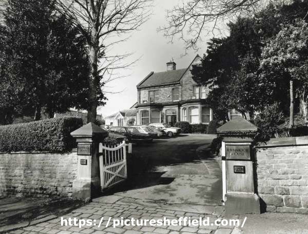
-
Sheffield Water Works Company conduit remains
Ponytail replied to Calvin72's topic in Sheffield History Chat
Plan of an Estate near Fulwood. 1868. Architects: Fowler and Son, Sheffield. Pawson and Brailsford, Lithographers, Sheffield. https://www.picturesheffield.com/frontend.php?keywords=Ref_No_increment;EQUALS;y11281&pos=49&action=zoom&id=104296 Shows Brown Hills Lane; also Sheffield Water Works conduit from Redmires to Sheffield. (at the top of the map) Owners / tenants: John Sheldon, esquire, Joseph Green and Sprotley School, Stephen Fox, Samuel Shore, esq., John Broomhead, The Duke of Norfolk, and William Waterfall, esq. Original at Sheffield Local Studies Library: Sale Plans 4 August 1868. -
Plan of several Estates the property of [William - changed to James] Boothby situate at West Grove near Sheffield, 1828. https://www.picturesheffield.com/frontend.php?keywords=Ref_No_increment;EQUALS;arc04200&pos=12&action=zoom&id=105084 Marked: Birley's Charity Land, Turnpike Road from Barnsley to Sheffield [Pitsmoor Road], Harvest Lane, proposed streets; land [belonging to George Bustard Greaves Esquire, Mr Duke’s property, Jonathan Marshall, Esquire; Mr Harmer, Thomas Naylor, Pie Bank [Pye Bank], pleasure ground, farm yard, Middle Field Garden, Far Field, gardens occupied by Mr Needham, Lingard, Hewitt, Rawson, Richardson and Wostenhome, Robinson, Kent, Bingley, Twigg, and Kitchen.
-
Booth & Co., Park Iron Works, Brightside Forge & Royds Mill.
Ponytail posted a topic in Made In Sheffield
History of Booth & Co. https://www.gracesguide.co.uk/Booth_and_Co#General A Map of the Lands and Works in the north park of Sheffield Park. 1788. https://www.picturesheffield.com/frontend.php?keywords=Ref_No_increment;EQUALS;y09966&pos=2&action=zoom&id=65481 Amongst others named: John Booth & Co. 19. Little Bank with House. 21.The Meadow. 22 & 20. Furnace Foundry and other Works. Road to the from Attercliffe Bridge, Dam and other Watercourses, Banks above the Dam and by the River. (Property near to Royds Mill Weir) Also Marked: River Sheaf; Hospital Grounds; Land held by Wm. Shipley; Road to the Farms in the Park, Cricket Inn Road; Castle Orchards; wear (weir); River Dun (Don); Simon Wheel Upper Dam; Simon Wheel Lower Dam; Simon Wheel; Walk Mill Wear (Weir); Royds Mill Wear (Weir); Furnace Dams; Dewee Close; Other Tenants: Thomas Taylor; Isaac Mower; Robert Rawson at Castle Orchards; Thomas Rodgers; Benjamin Blonk & Co. at Simon Wheel; John Woollas; John Froggatt; Benjamin Taylor; Samuel Revil; Hannah Hodgkinson; William Shipley; James Furniss; William Lord; R. Magnall and Ric'd Falkner; John Barber; James Kaye; John Steer; William Smith; William Kent & John Jowel. (Top of left of Map think it says) "Pencil? Numbers? Harrison Survey 1639. Also (parts listed) Surveyed W Fairbank 1789. A Plan of the Forges Tenements and works Brightside held of the Duke of Norfolk by John Booth and Co, drawn 1790, updated c.1810. (dated 2nd September 1811) https://www.picturesheffield.com/frontend.php?keywords=Ref_No_increment;EQUALS;arc01852&pos=1&action=zoom&id=18564 "The Fall from the top of Brightside Forge Wear (Weir) to the top of Brightside Paper Mill Wear to the middle of the wear at (a) is 8ft 7 1/2. From (d) to the south end of the wear at (b) is 8ft 5 1/2." "Held by the first long lease along with the Goights and Dam marked *. No. 3 New Forge and Rolling Mill with the Ground. No. 4 Dwelling House and Garden. No. 5 Close or Croft. No. 6 Forge and other buildings Dam Gardens & Lane leading to the Forge." Coloured Green (gives measurements) "Held by the second long lease Coloured Yellow No. 2 Two Houses with Gardens and other Ground." "Held by Common Lease No.1 A Close called The Holme. No. 7 The Island." (gives measurements) "* From the Compting House corner to the Company's Hedge next Lucy Southerons is Four Feet. August 5th 1804." Marked: River Dun (Don); Brightside Forge Wear (Weir); Forge & etc (Brightside Forge); Garden; Charcoal Yard; Road to Sheffield; Brightside Green; Road to Tinsley and Rotherham; New Forge & Brightside Paper Mill Wear (Weir). Also named: Earl Fitzwilliam's Land; John Whetham Esq.; Duke of Norfolk and late John Hartops. A Plan of the Houses and Ground near Brightside demised to J. Booth and Co. 1789. (Between Weedon Street and the River Don.) https://www.picturesheffield.com/frontend.php?keywords=Ref_No_increment;EQUALS;arc02690&pos=2&action=zoom&id=91532 Marked: Lane from Carbrook to Brightside & The Dun (River Don). Other Tenants: William Binks, tenant; Close held by the Widow of John Hartop. House, Garden, etc proposed to be taken of the Duke of Norfolk for the term of 99 years by John Booth and Co. 1796. (Between modern Effingham Road and the Park Furnace Dam.) https://www.picturesheffield.com/frontend.php?keywords=Ref_No_increment;EQUALS;arc03392&pos=3&action=zoom&id=98631 Also marked: Furnace Dam & Road to the works of J. Booth & Co. Iron Works of William Booth & Co, https://www.picturesheffield.com/frontend.php?keywords=Ref_No_increment;EQUALS;arc03547&pos=1&action=zoom&id=98880 Heald (Held) by a Common Lease: Upper Meadow; Lower Meadow; Little Bank; Above the Dam including the road and road by the River; upper part of H. Hodgkinsons Close. Heald by the first long lease: Old Dam with the goight leading to it from the River. Heald by second long lease: New Reservoir Banks & Watercourses round it. Furnace and other Works & Ground about them. House & Garden. Booth & Co. Park Foundry: (Copy) Minutes of meeting of the partners (Sayle, Shore, Binks, Hartop and Booth). 6th Jan 1825. https://discovery.nationalarchives.gov.uk/details/r/39bd2d25-afae-4ae7-9af9-8a1f07e8159d -
S. Newbould’s premises on Little Sheffield Moor, and John Taylor’s house, 1787. https://www.picturesheffield.com/frontend.php?keywords=Ref_No_increment;EQUALS;arc03771&pos=28&action=zoom&id=99407 Land purchased of the Duke of Norfolk by Samuel Newbould and Thomas Holy at Little Sheffield. 1803. https://www.picturesheffield.com/frontend.php?keywords=Ref_No_increment;EQUALS;arc04083&pos=7&action=zoom&id=72460 Several fields between Broom Hall Lane and The Moor, across which Clarence Street was afterwards made. The line is indicated on this plan. Shows Broomhall Lane, Younge Street and Samuel Newbould’s property. William brother of Samuel Newbould. (Information from Grace's Guide, "The second son William (1749-1802) married Sarah, daughter of Thomas Holy, button manufacturer, and was in partnership with his father-in-law.") Ground on Little Sheffield Moor demised by the Marquis of Rockingham to T Holy and William Newbould, 1776. https://www.picturesheffield.com/frontend.php?keywords=Ref_No_increment;EQUALS;arc03770&pos=27&action=zoom&id=99406 House, workshops, erected on the leasehold ground of Thomas Holy and William Newbould, [The Moor], 1790. https://www.picturesheffield.com/frontend.php?keywords=Ref_No_increment;EQUALS;arc04259&pos=23&action=zoom&id=34922 Marked: William Newbould, T. Holy's house, warehouse, etc. (Information from Grace's Guide "The Newboulds were tilting at Loxley. Miller remarked: “Old Wheel Dam . . . would seem to have run both a tilt and a grinding wheel in the early part of the nineteenth century, when for seventy or eighty years, the property was owned by the Newboulds. Messrs. Samuel Newbould and Co. were tilters here for a considerable period but the Dentons leased the forge from somewhere about 1845 to 1885.”) Plan of an Estate situated at the Old Wheel in the Parish of Bradfield the property of S Newbould. 1820. https://www.picturesheffield.com/frontend.php?keywords=Ref_No_increment;EQUALS;y09601&pos=4&action=zoom&id=3529 Plan of land at Loxley intended to be sold to Samuel Newbould (part between Old Wheel Dam and Storrs Wheel), by W. and J. Fairbank. 1825. https://www.picturesheffield.com/frontend.php?keywords=Ref_No_increment;EQUALS;y09598&pos=6&action=zoom&id=44514
-
Maps of the Parish of Handsworth, based on the Enclosure Award Maps (1805) and corrected up to 1855.
Ponytail replied to Ponytail's topic in Sheffield Maps
Map of Woodhouse Junction area, c.1855. https://www.picturesheffield.com/frontend.php?keywords=Ref_No_increment;EQUALS;arc02940&pos=1&action=zoom&id=93148 Includes: Green Gate Lane; Birley Vale Branch Railway, Beighton Branch Railway, Manchester Sheffield and Lincolnshire Railway; River Rother; Woodhouse Colliery; Woodhouse Mills; Shirecliffe Brook; Cinderhill Green Road; Furnace Lane, Woodhouse Junction Station; Shaft. From a volume of Maps of the Parish of Handsworth, based on the Enclosure Award Maps (1805) and corrected up to 1855. Dimensions of original: 34 x 51cm. Original at Sheffield City Archives: CA369/1. -
Maps of the Parish of Handsworth, based on the Enclosure Award Maps (1805) and corrected up to 1855.
Ponytail replied to Ponytail's topic in Sheffield Maps
Map of Beighton Lane area, c.1855. https://www.picturesheffield.com/frontend.php?keywords=Ref_No_increment;EQUALS;arc02939&pos=2&action=zoom&id=93343 Includes: Birley Vale Branch Railway, Beighton Lane, Lamb Croft Lane, Quarry, Ochre Dyke, Cliff Bridge and Green Gate Lane. From a volume of Maps of the Parish of Handsworth, based on the Enclosure Award Maps (1805) and corrected up to 1855. Dimensions of original: 34 x 51cm. Original at Sheffield City Archives: CA369/1. -
Maps of the Parish of Handsworth, based on the Enclosure Award Maps (1805) and corrected up to 1855.
Ponytail replied to Ponytail's topic in Sheffield Maps
Map of Woodthorpe Common, c.1855 https://www.picturesheffield.com/frontend.php?keywords=Ref_No_increment;EQUALS;arc02932&pos=6&action=zoom&id=93431 Includes: Woodhouse Road, Richmond Road, Normanton Hill, Four Lane Ends, Birley Vale Branch Railway and Intake. From a volume of Maps of the Parish of Handsworth, based on the Enclosure Award Maps (1805) and corrected up to 1855. Shows: Coke Ovens. Dimensions of original: 34 x 51cm. Original at Sheffield City Archives: CA369/1. -
Maps of the Parish of Handsworth, based on the Enclosure Award Maps (1805) and corrected up to 1855.
Ponytail replied to Ponytail's topic in Sheffield Maps
Map of Richmond, Woodthorpe, etc. c.1855 https://www.picturesheffield.com/frontend.php?keywords=Ref_No_increment;EQUALS;arc02933&pos=7&action=zoom&id=93433 Includes Woodhouse Road, Richmond Road, Normanton Hill, Four Lane Ends, Birley Vale Branch Railway and Intake. From a volume of Maps of the Parish of Handsworth, based on the Enclosure Award Maps (1805) and corrected up to 1855. Shows: Coke Ovens. Dimensions of original: 34 x 51cm. Original at Sheffield City Archives: CA369/1. -
Dore Enclosure Map. 1822. https://www.picturesheffield.com/frontend.php?keywords=Ref_No_increment;EQUALS;arc07355&pos=15&action=zoom&id=106542 Marked: Manor of Hathersage, Burbage Brook, Burbage Rocks, Road from Buxton, Fox House, Buxton Turnpike Road [Hathersage Road], Road from Dronfield, Road from Stoney Middleton, Wooden Pole Road Stony Ridge Road], Dore Turnpike Road, Totley Moors, Dore, Chapel, Oxen Green, Road from Totley, Newfield Lane Road, Limb Gate [on Limb Lane], Standhills, Limb Dyke, Barber Fields, Spring, Ringing Low [Ringinglow], Site of Ringinglow Toll House and Norfolk Arms pub, Ringing Low Road [Long Line], Sparrowpit Gate Turnpike Road [Ringinglow Road], Ox Stones, Oxstone Dale Road, Parkinsons Spring, Red Car Road [Sheephill Road], Aqueduct, Sheep Hill Sping, Me and Jane [Meg and Jane?] Spring White Low Spring, White Low Road, Round Seats, Strawberry Lee Road, Upper Causeway Head, Intake Road [Ash House Lane], Nether Causey Head Road [Parkers Lane / Causeway Head Road], Whirlow Road [Rushley Road]. Tenants / owners marked: Numerous plots - Duke of Devonshire; 29, 30 James Wagstaff; 42 John Frith; 41, 44 Vicar of Dronfield; 50 Curate of Dore; 2, 36, 36a and 85 John Shearwood; 74, 75 Charles Greenwood; 65, 65a, 78, 79 School and Poor; 66 G. B. Greaves; 63, 86 Samuel Shore; 51, 87 Thomas Biggin; 31, 88 Hollis's Hospital; 73, 89 Edward Sampson; 62, 90 W. C. Bagshawe; 52, 91 John Cartledge; 34, 93 John Unwin; 93a I. Shepherd; 14, 32, 94 Henry Hancock; 61, 95 Thomas Fernehough; 6, 33, 96 Robert Moss; 37, 98 and 98 William Cunliffe Shawe; 49, 99 Sir George Sitwell; 48, 100 Dr Ewes Coke; 101 Thomas Bingham, clerk; 102 Joseph Badger's devisees; 103-104 George Canning Esquire; 71 W.G.; 70 P.T.?; 69 P.P.; 68 J.D.; 76 H.M. Scale: approx 5 inches : 1 mile. Surveyors: W and J Fairbank. Signed by the Enclosure Commissioners. Original at Sheffield City Archives: CA361/2.
