Search the Community
Showing results for 'coal pit lane'.
-

Godfrey Maps of Sheffield 1901 - 1905 Index of names dwellings L-R
Stuart0742 replied to Stuart0742's topic in Sheffield Maps
Oliver Wheel Off Green lane Sheet 288.08 Ecclesfield 1901 -
Godfrey Maps of Sheffield 1901 - 1905 Index of names dwellings L-R
Stuart0742 replied to Stuart0742's topic in Sheffield Maps
Olive Terrace Black lane Sheet 294.02 Sheffield (Loxley Valley) 1902 -
Godfrey Maps of Sheffield 1901 - 1905 Index of names dwellings L-R
Stuart0742 replied to Stuart0742's topic in Sheffield Maps
Oaks, The Shirecliffe lane Sheet 294.04 Sheffield (North) 1905 1901 census link http://www.sheffieldhistory.co.uk/forums/i...ost&p=40881 -
Godfrey Maps of Sheffield 1901 - 1905 Index of names dwellings L-R
Stuart0742 replied to Stuart0742's topic in Sheffield Maps
Nursery House Richmond lane Sheet 295.10 Sheffield Handsworth -
Godfrey Maps of Sheffield 1901 - 1905 Index of names dwellings L-R
Stuart0742 replied to Stuart0742's topic in Sheffield Maps
Nunnery Farm end of Nunnery lane Sheet 295.05 Sheffield (Darnall) 1903 -
Godfrey Maps of Sheffield 1901 - 1905 Index of names dwellings L-R
Stuart0742 replied to Stuart0742's topic in Sheffield Maps
Norwood Rise Cockshutt lane Sheet 288.16 Sheffield (Longley) 1902 -
Godfrey Maps of Sheffield 1901 - 1905 Index of names dwellings L-R
Stuart0742 replied to Stuart0742's topic in Sheffield Maps
Norwood Hall Norwood lane Sheet 288.16 Sheffield (Longley) 1902 -
Godfrey Maps of Sheffield 1901 - 1905 Index of names dwellings L-R
Stuart0742 replied to Stuart0742's topic in Sheffield Maps
Norwood Grange Piper lane Sheet 288.16 Sheffield (Longley) 1902 -
Godfrey Maps of Sheffield 1901 - 1905 Index of names dwellings L-R
Stuart0742 replied to Stuart0742's topic in Sheffield Maps
Norwood Farm Piper lane Sheet 288.16 Sheffield (Longley) 1902 -
Godfrey Maps of Sheffield 1901 - 1905 Index of names dwellings L-R
Stuart0742 replied to Stuart0742's topic in Sheffield Maps
Nether House Storth lane Sheet 294.10 Fulwood & Ranmoor 1903 -
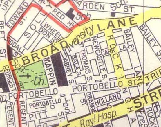
I'm trying to find Bala Street (It's where my great grandfather lived) on the alphabetical maps. Its Portobello - Broad Lane. St Thomas Street. Just can't find the section that it's in. It should be around Map no. 274, or No.3 or No.2 area I've scoured everything around there but no luck. Any help appreciated. I've found it on another map -- Below -- but the others seem a bit more detailed, showing individual properties. I managed to find a photo on picture Sheffield.

-
hi dunsbyowl could you put the next one up from map 5 towards broughton lane? i lived at newton terrace over the wall from st barts church the side of clifton st but the map just falls short of it. thank you. great detailed maps.
-
REVISED 02/07/09 Hi, Ref.again, the photo that started this topic. About 18 months ago, on Sheffield Forum, there was request for information regarding the location of an Annex to the Children's Hospital that was in the Wicker Area. I understand the Hospital's records make reference to its existance but don't give any details. Where ever it was, it was closed in 1931. We do know that it was called the East End Branch and first located at 86 Wicker in 1893, then moving to a, supposedly, purpose-built building on Nursery Street in 1913. Now, there were only three buildings on the old Nursery Street that had ever seen the hand of an Architect. These were: The Coronor's Court building at the corner of Wicker Lane, Holy Trinity Church at the corner of Johnson Street and the front section of the GH Lawrence property. What do you think? Regards
-
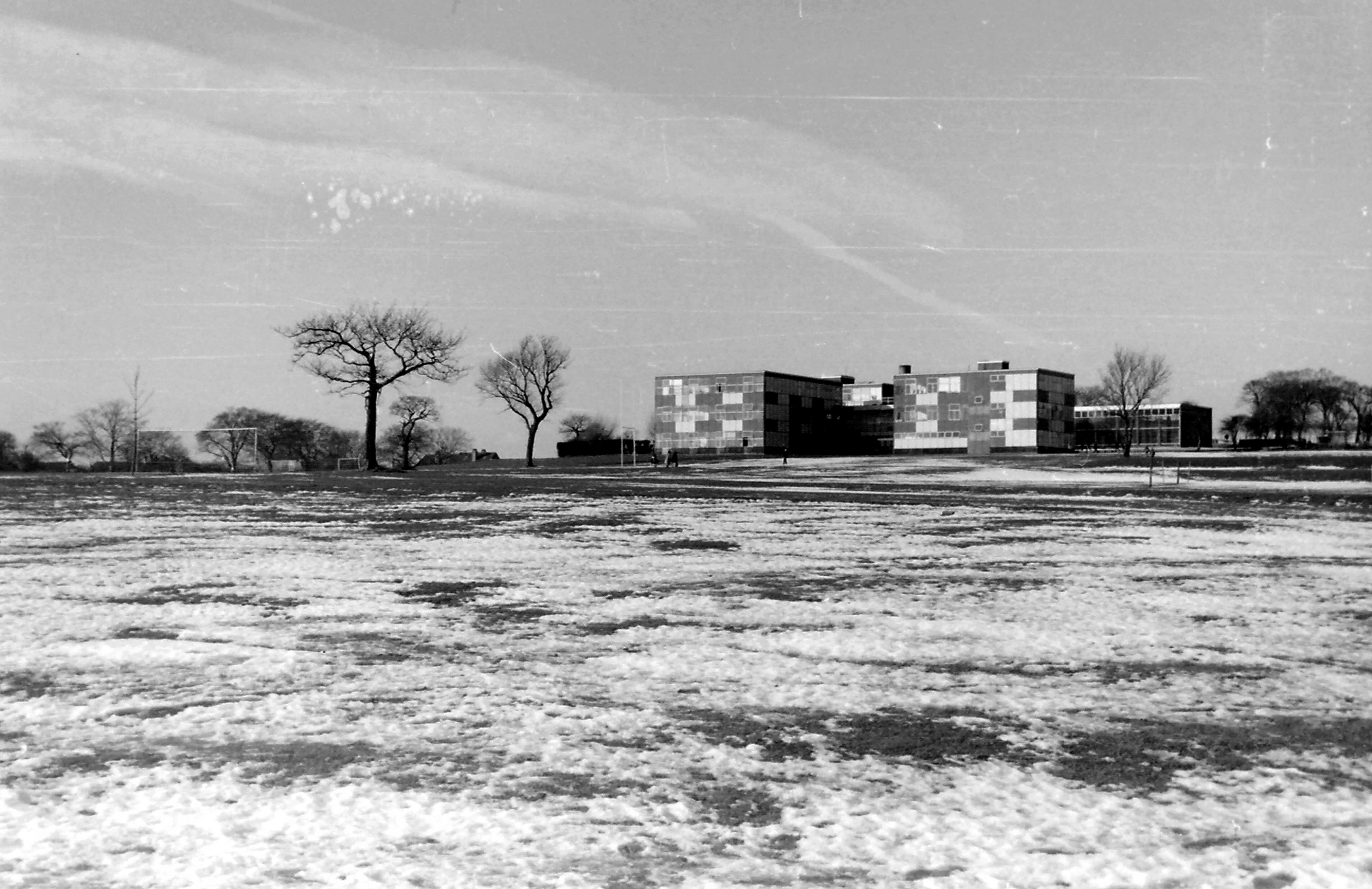
This is Ashleigh lower school in January 1973 on a cold, snowy day. Ashleigh lower was, before it became comprehensive in 1969, Hurlfield Girls School on Hurlfield Road near the water works and Hag lane tanks. The building was demolished in 1984 and replaced with a small private housing estate in 1988 Ex students of Ashleigh will know that as well as being the lower school for years 1-3 (or 7 - 9 as they are now) it was also the centre for the art department, it had the best hall of the 2 buildings witha proper stage and a depressed hall "dancefloor" and, worst of all, to get to the upper school (ironically at a lower level down the hill) you either had to walk across that muddy dirty field, or take a longer route on a footpath which went past a smelly old pigstye.

-
Godfrey Maps of Sheffield 1901 - 1905 Index of names dwellings L-R
Stuart0742 replied to Stuart0742's topic in Sheffield Maps
Myrtle Bank Grange lane Sheet 295.10 Sheffield Handsworth -
Godfrey Maps of Sheffield 1901 - 1905 Index of names dwellings L-R
Stuart0742 replied to Stuart0742's topic in Sheffield Maps
Myers Grove House Myers Grove lane Sheet 294.02 Sheffield (Loxley Valley) 1902 -
Godfrey Maps of Sheffield 1901 - 1905 Index of names dwellings L-R
Stuart0742 replied to Stuart0742's topic in Sheffield Maps
Mount, The Glossop Road/ Newbould lane Sheet 294.11 Ecclesall & Sharrow 1903 -
Godfrey Maps of Sheffield 1901 - 1905 Index of names dwellings L-R
Stuart0742 replied to Stuart0742's topic in Sheffield Maps
Moonshine Moonshine lane Sheet 288.15 Sheffield (Hillsborough) 1902 -
Godfrey Maps of Sheffield 1901 - 1905 Index of names dwellings L-R
Stuart0742 replied to Stuart0742's topic in Sheffield Maps
Marsh House Junction of High Storrs Road & Haig lane Sheet 294.14 Ecclesall Village 1902 -
Godfrey Maps of Sheffield 1901 - 1905 Index of names dwellings L-R
Stuart0742 replied to Stuart0742's topic in Sheffield Maps
Manor Lodge (Ruins) Manor lane Sheet 294.12 Sheffield Park 1903 -
Godfrey Maps of Sheffield 1901 - 1905 Index of names dwellings L-R
Stuart0742 replied to Stuart0742's topic in Sheffield Maps
Manor Cottage off Manor lane Sheet 295.05 Sheffield (Darnall) 1903 -
Godfrey Maps of Sheffield 1901 - 1905 Index of names dwellings L-R
Stuart0742 replied to Stuart0742's topic in Sheffield Maps
Lydgate Hall Marsh lane Sheet 294.06 Sheffield (Rivelin Glen) 1902 -
Godfrey Maps of Sheffield 1901 - 1905 Index of names dwellings L-R
Stuart0742 replied to Stuart0742's topic in Sheffield Maps
Longley House Carr lane Sheet 288.16 Sheffield (Longley) 1902 -
Godfrey Maps of Sheffield 1901 - 1905 Index of names dwellings L-R
Stuart0742 replied to Stuart0742's topic in Sheffield Maps
Longley Farm Carr lane Sheet 288.16 Sheffield (Longley) 1902 -
Godfrey Maps of Sheffield 1901 - 1905 Index of names dwellings L-R
Stuart0742 replied to Stuart0742's topic in Sheffield Maps
Lodge Opposite lane End Farm Sheet 282.15 High Green & Thorncliffe 1903