Search the Community
Showing results for 'coal pit lane'.
-
St Mary's on what I think is the junction of Bramhall Lane and St Mary's Gate.
-
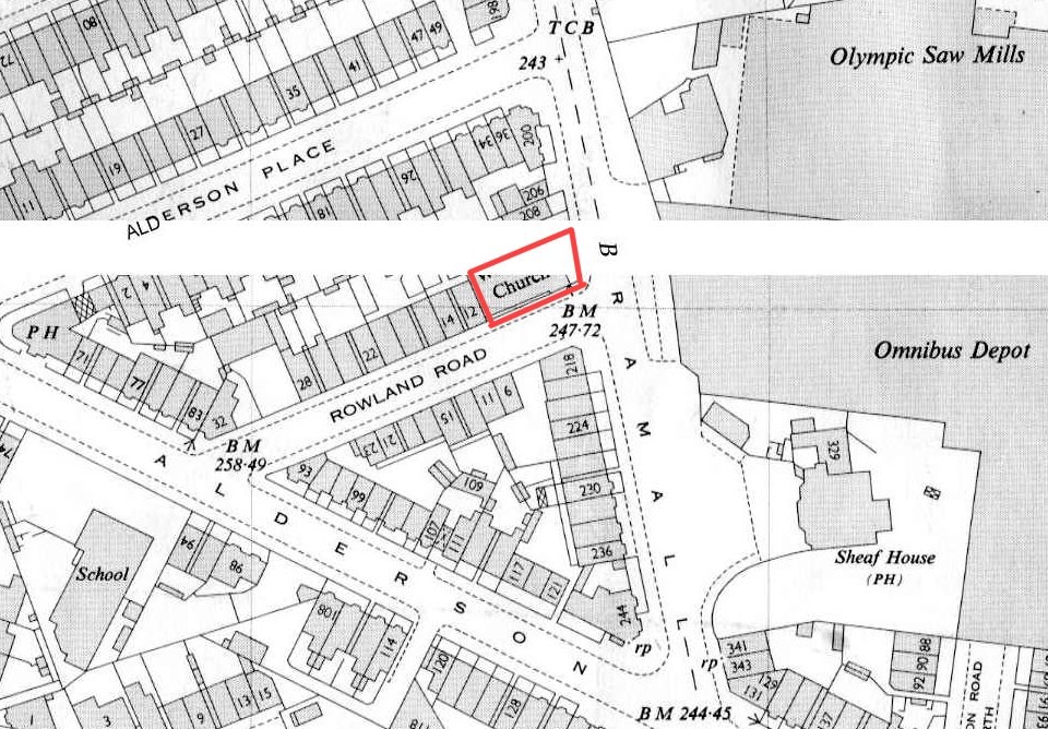
Can someone put a name to this church on the corner of Rowland Road and Bramall Lane, please.
-
Thanks - it's the ones actually on School Green Lane that I'm looking for (and the 2 or 3 in my list)
-

Os Maps Of Sheffield And District (1950's) - Over 300 Of Them !
SteveHB replied to RichardB's topic in Sheffield Maps
Map 23 - Bramall Lane, S.U.F.C. ground, Shoreham Street, Hill Street, Alderson Road, Holland Road, St Mary's Road (part of) area. © Crown Copyright 1953, Reproduced by kind permission of the Ordnance Survey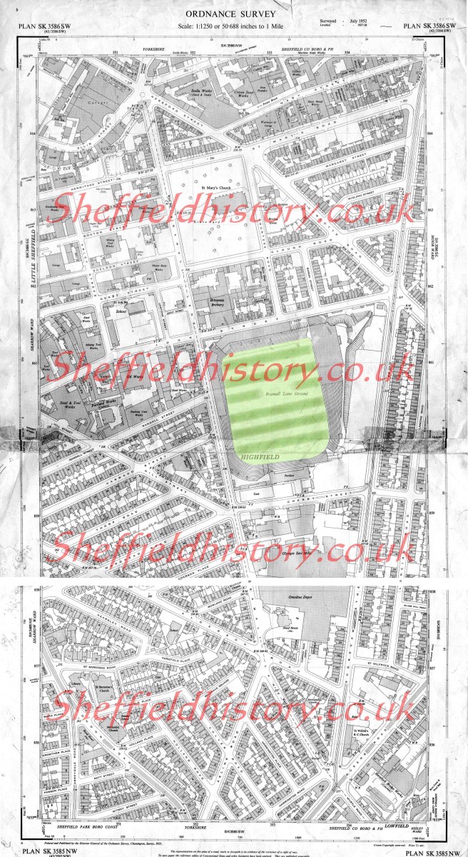
-
Hi i know its a long shot, but does anyone have any old photos of Weddings that took place at St Barts Church, Carbrook - the top of carbrook street from 1950's-onwards. I lived over the wall from there Newton terrace and saw many a wedding stood in our yard with my chin on our wall looking over .. My Grandad was the caretaker. What it is i have searched and searched but can't find a picture of the row of houses I lived in if someone took a photo of a wedding maybe they might have took the picture of our house as well. Since back then there was no cropping or enhancing pic's so I might get lucky.. I also tell people where i lived but no one seemes to remember these houses there was a row of houses at the front of us. just before clifton street going towards broughton lane. i lived there from 1955-69 when we had to move as was being demolished. but my aunt had the house before us before taking over the Excelcior pub top of Carbrook Street. Ii am also looking for any photo's taken on the same side of the church looking across. where all the row of shops was. for example. Lants chip shop./samick motors etc... but lower if anyone has them passed Carbrook St where Jacksons chip shop was... here's hoping.. Thanks
-
Gilmour Pubs in the Sheffield area. Broughton Inn, 343 Attercliffe Common . Dog & Partridge, 56 Trippet Lane. Hillsborough Hotel, 54 Langsett Road. New Barrack Tavern, Penistone Road. Norfolk Arms*, Carlisle Street East. North Pole*, Sussex Street. Old Crown, 137 London Road. Red Deer, Pitt Street. Lion Hotel, (Riverside Court Hotel) 2 Nursery Street. The Lodge Inn, Spital Hill. Rutland Arms, 86 Brown Street. The Pheasant, (Stumble Inn) 436 Attercliffe Common. The Bull & Mouth (Tap & Barrel), Waingate. White Lion, 615 London Road. Woodseats Hotel, (The Woodseats) 743 Chesterfield Road. Rivelin Hotel, Tofts Lane. Anymore out there ?
-
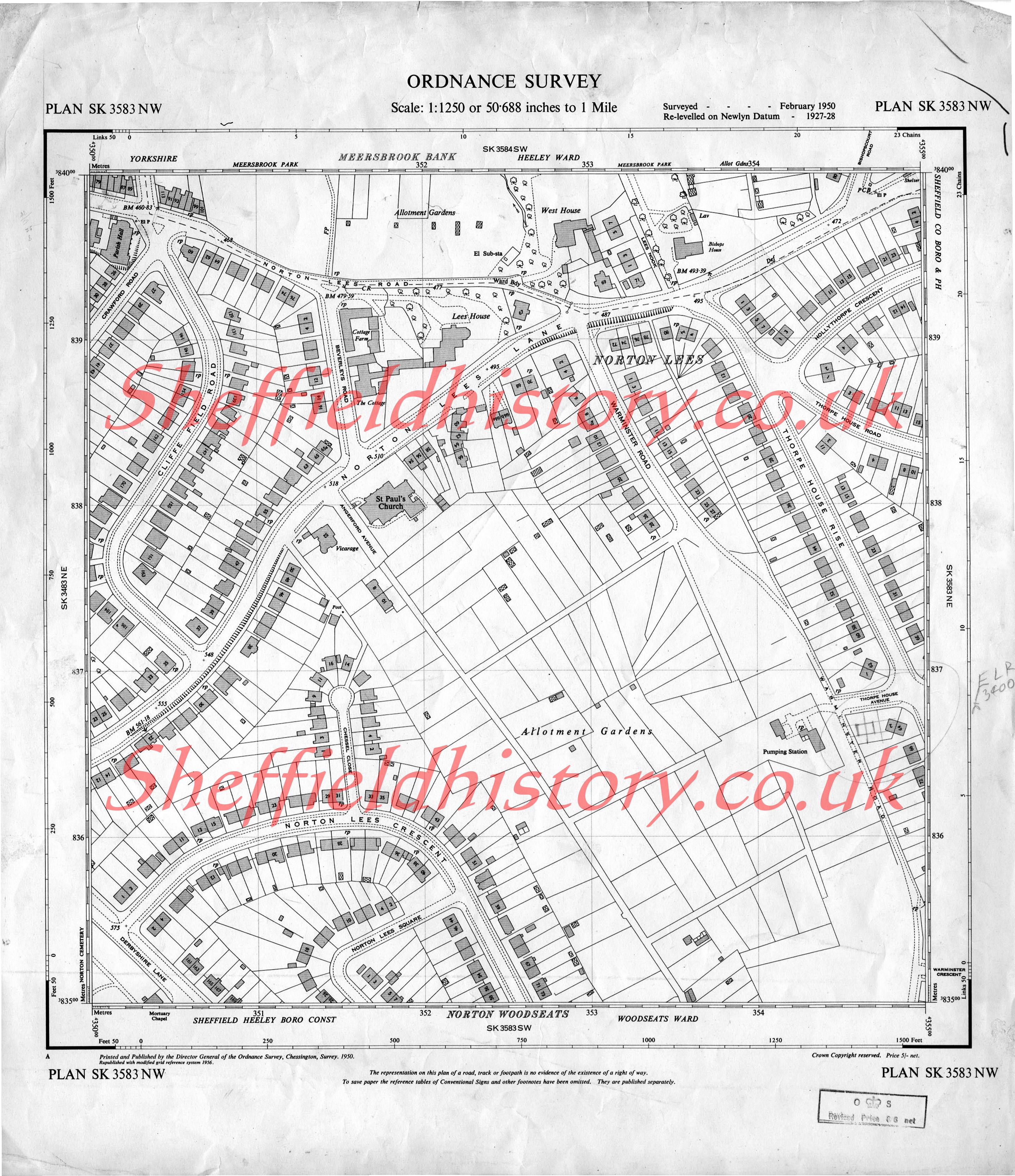
Os Maps Of Sheffield And District (1950's) - Over 300 Of Them !
SteveHB replied to RichardB's topic in Sheffield Maps
Map 16 - Norton Lees Road/Lane, Thorpe House Rise, Warminster Road, Norton Lees Crescent (part of), area. SK3583NW © Crown Copyright 1956, Reproduced by kind permission of the Ordnance Survey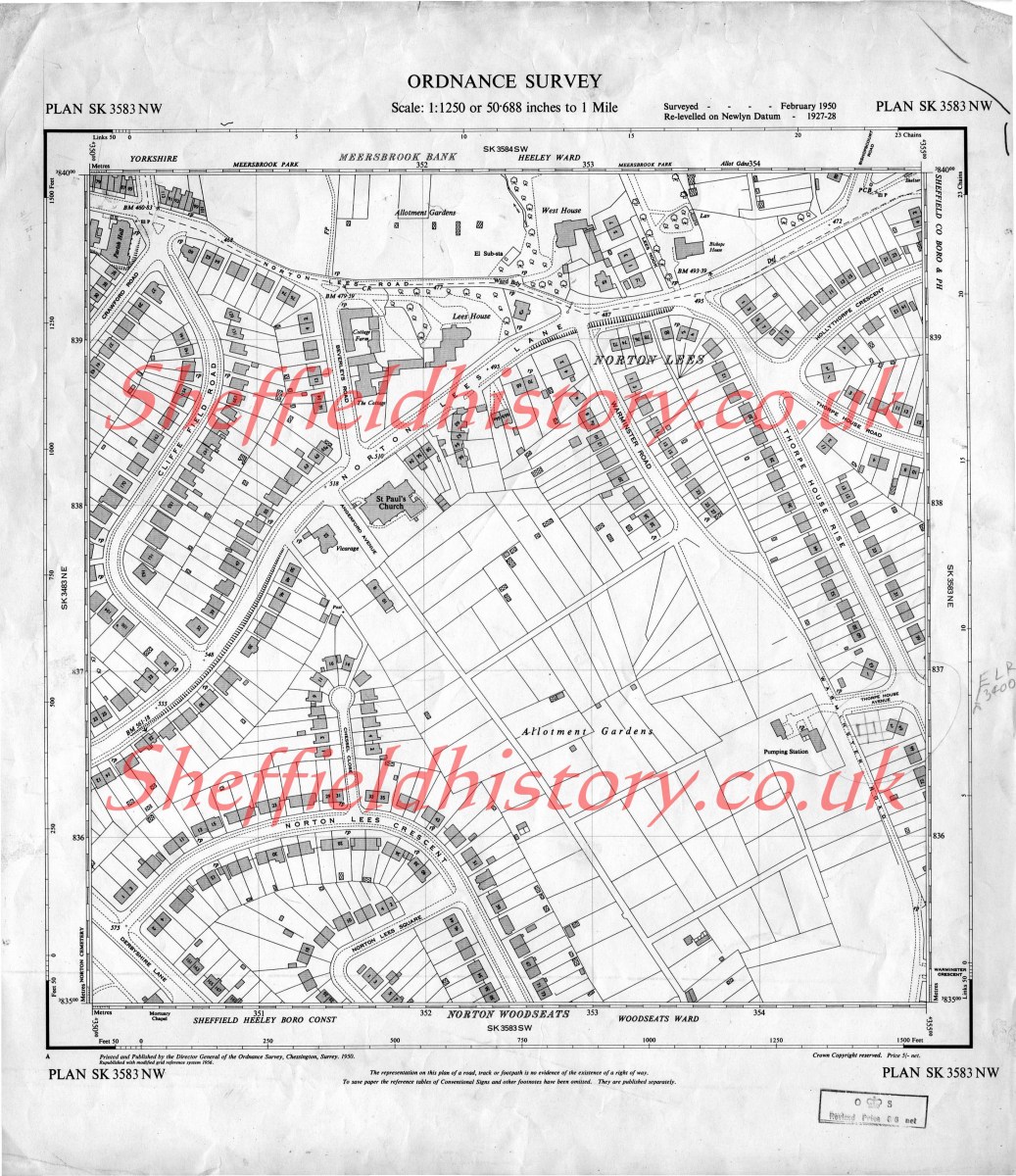
-
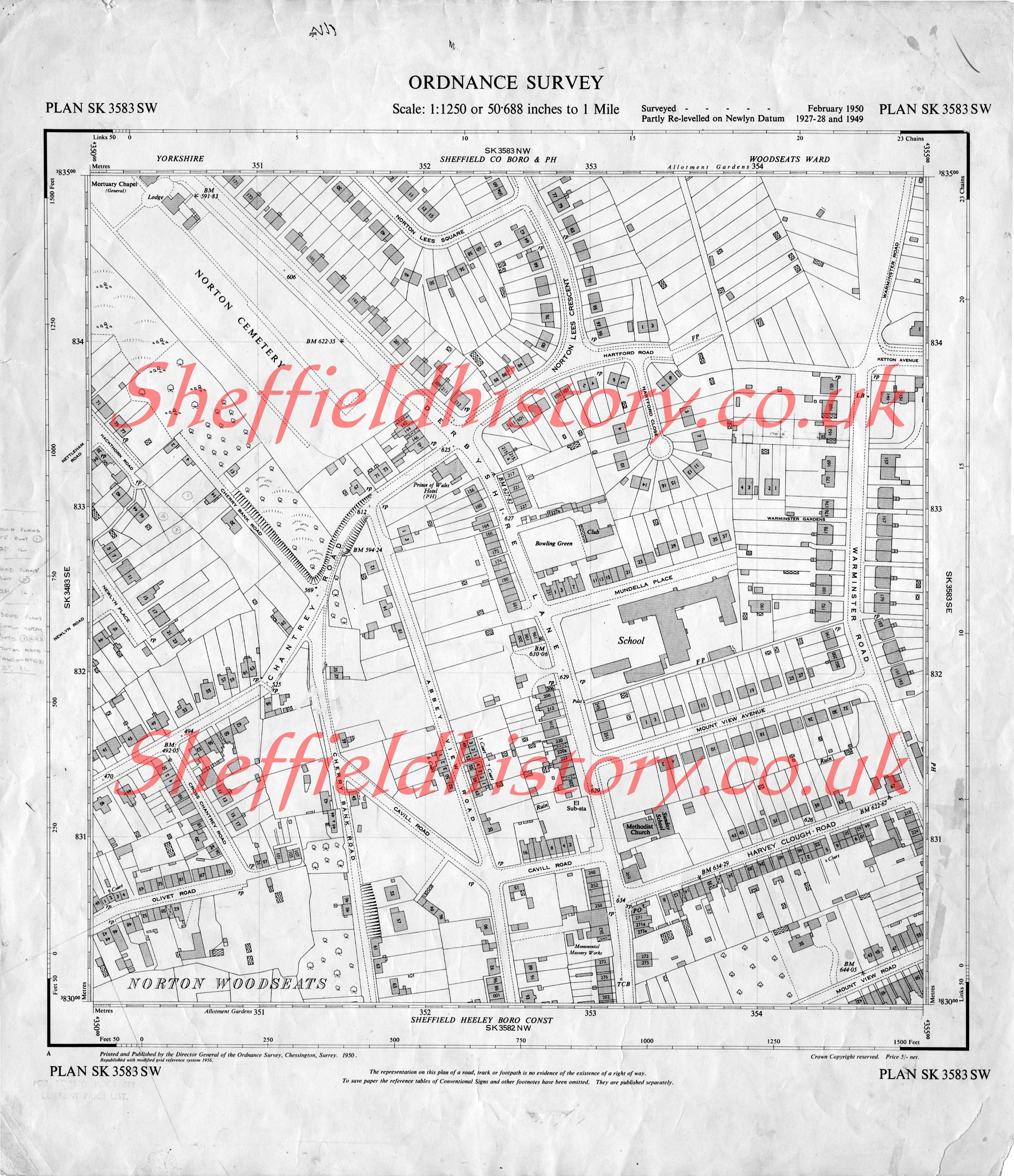
Os Maps Of Sheffield And District (1950's) - Over 300 Of Them !
SteveHB replied to RichardB's topic in Sheffield Maps
Map 15 - Deryshire Lane, Warminster Road, Chantrey Road, area. SK3583SW © Crown Copyright 1956, Reproduced by kind permission of the Ordnance Survey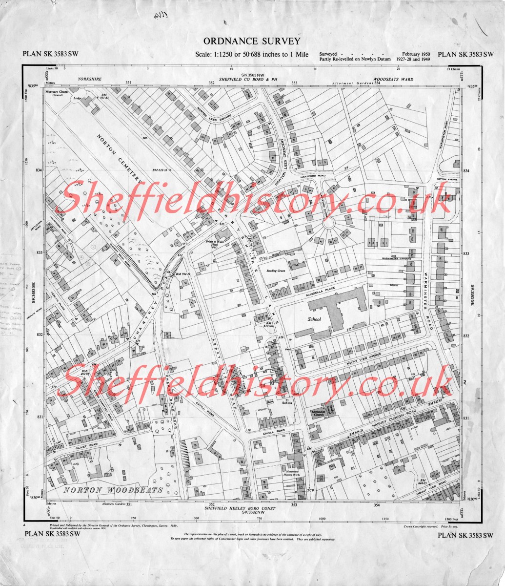
-
David Lane Farm is just off School Green Lane. Other farms in the area- Priest Hill Low Farm Bore Hill Farm New May House Farm Brown Hills Lane Farm Mill Lane Farm Bower Hill Farm Mill Views Farm
-
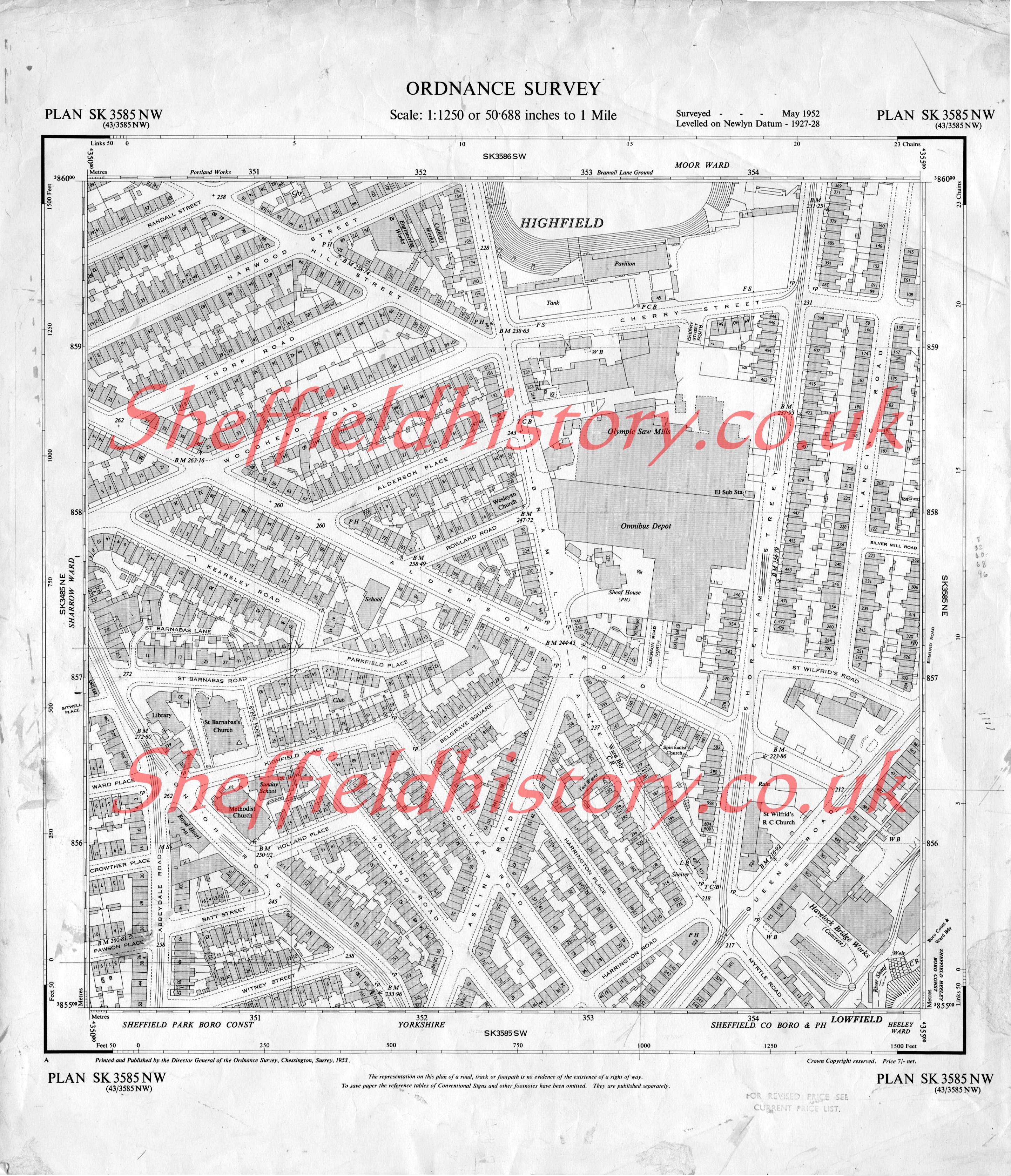
Os Maps Of Sheffield And District (1950's) - Over 300 Of Them !
SteveHB replied to RichardB's topic in Sheffield Maps
Map 13 - Bramall Lane, Shoreham Street, area. inc: Abbydale Road and Queens Road (part of) SK3585NW © Crown Copyright 1953, Reproduced by kind permission of the Ordnance Survey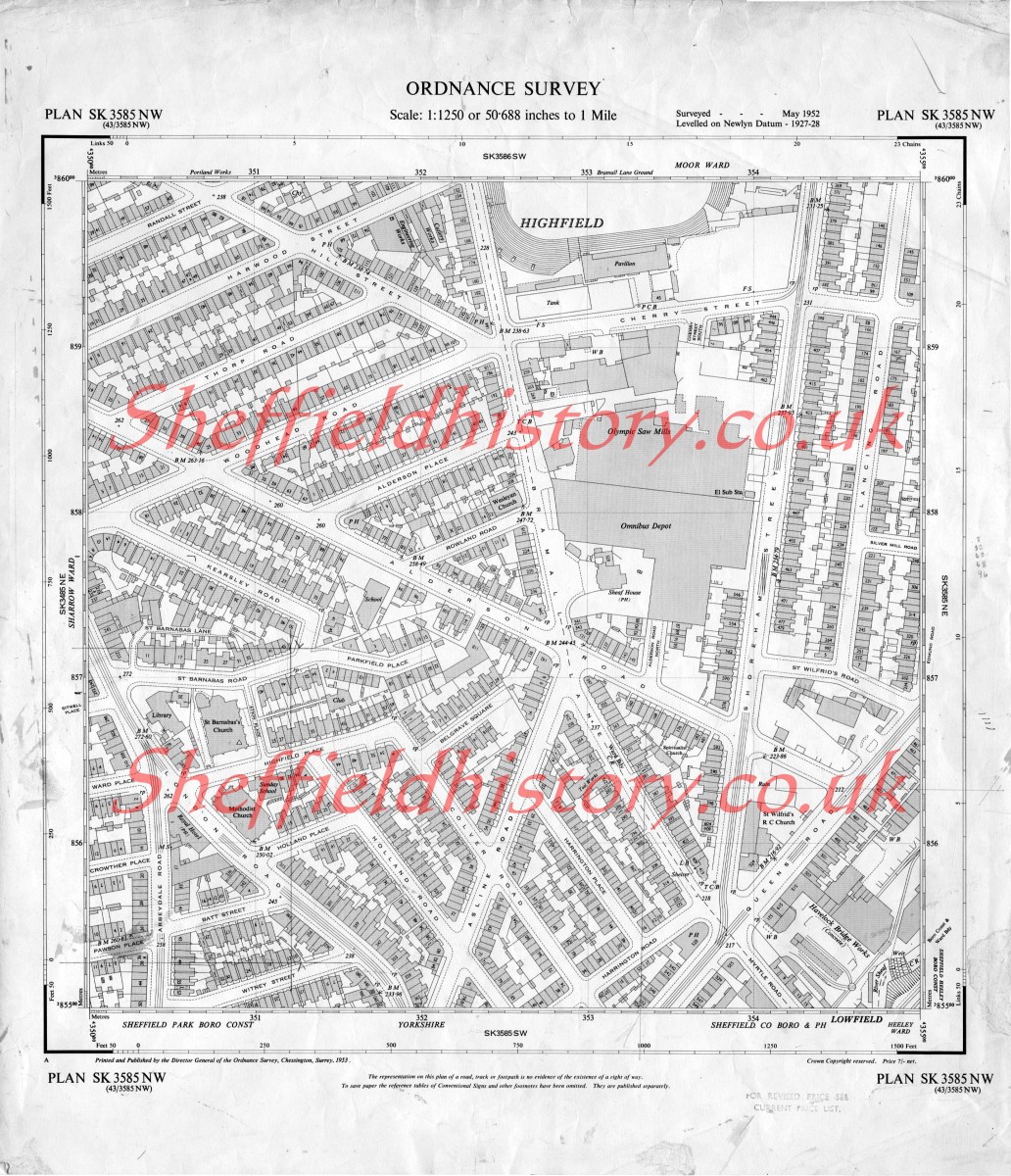
-
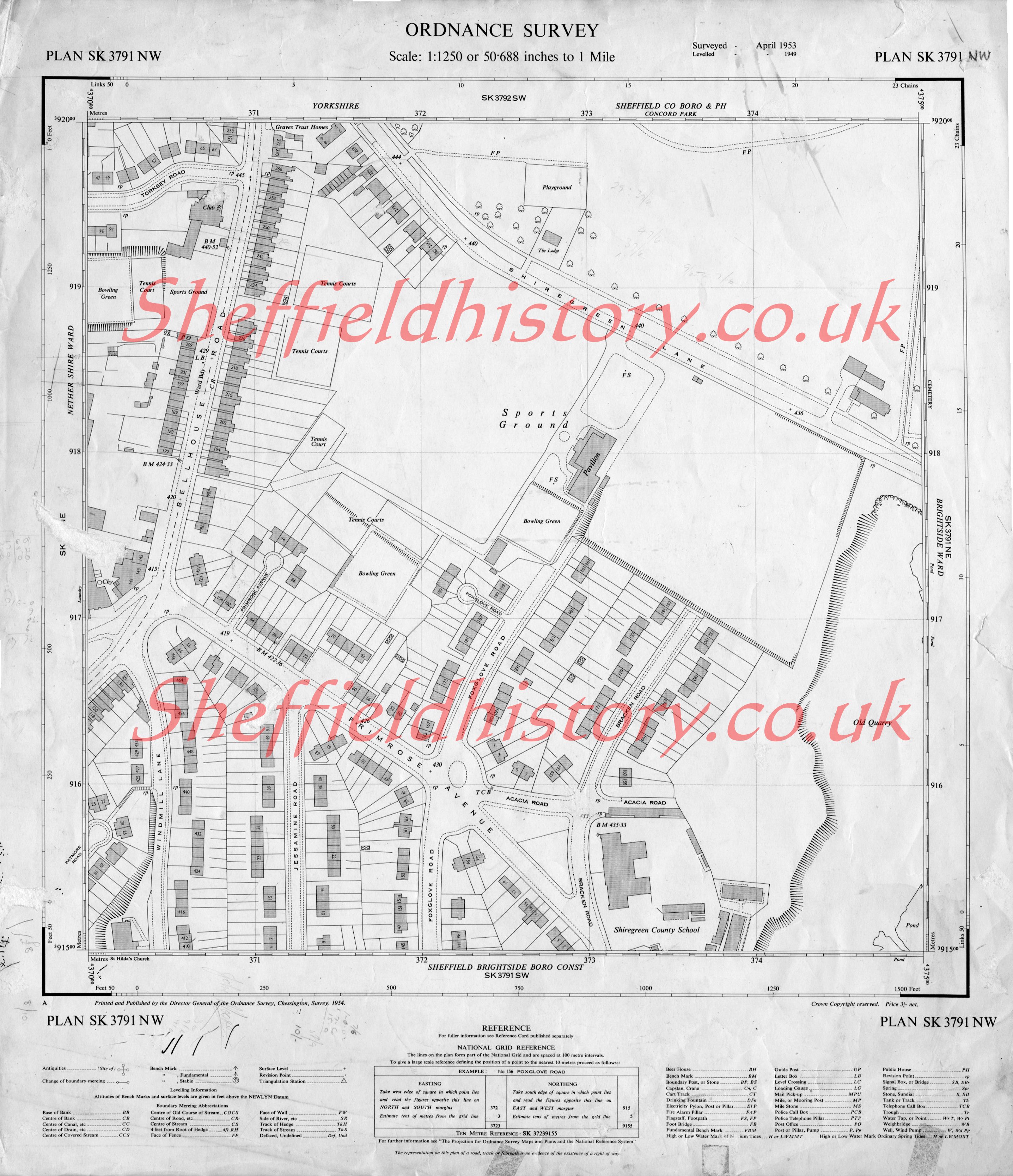
Os Maps Of Sheffield And District (1950's) - Over 300 Of Them !
SteveHB replied to RichardB's topic in Sheffield Maps
Map 7 - Shiregreen Lane, Bellhouse Road, Primrose Avenue, area SK3791NW © Crown Copyright 1954, Reproduced by kind permission of the Ordnance Survey
-
Does anyone know where these farms were? Lowfolds Oldfolds Old Field and which farms were on School Green Lane (as well as Jowett Farm)?
-
Thank you for putting the facts right POPPYCHRISTINA, think my knowledge of pubs compares to Richards photo editing capabilities And I was just thinking ... I worked across from the Lion Hotel when It's name changed So thanks to POPPYCHRISTINA we now have 14 ... Dog & Partridge, 56 Trippet Lane. Hillsborough Hotel, 54 Langsett Road. New Barrack Tavern, Penistone Road. Norfolk Arms*, Carlisle Street East. North Pole*, Sussex Street. Old Crown, 137 London Road. Red Deer, Pitt Street. Lion Hotel, (Riverside Court Hotel) 2 Nursery Street. The Lodge Inn, Spital Hill. Rutland Arms, 86 Brown Street. The Pheasant, (Stumble Inn) 436 Attercliffe Common. The Bull & Mouth (Tap & Barrel), Waingate. White Lion, 615 London Road. Rivelin Hotel, Tofts Lane. Can anyone add anymore ?
-
Old theatre - Upwell Street Grimesthorpe?
johnm replied to dunsbyowl1867's topic in Sheffield CInemas and Theatres
The Victory Cinema ( or "Bughut" as we all called it) was on the left hand side of Upwell Street going from Upwell Lane ( where Reform Chapel was on the corner ) towards Brightside, and was just before Chambers Lane intersected on the opposite side. I seem to recall there was a Doctors surgery close to it as well as the sweet shop. The building shown in the earlier photo was as you say a theatre - it was on the same side of Upwell St as Reform Chapel. I can't remember the name but I am sure someone on the Sheffield Forum website Grimesthorpe thread will know. I will ask. The Victory was great - all the kids went on Saturday mornings . I went to Reform Chapel and Grimesthorpe School ; my grandma lived on Rothay Road. -
Here are some of them, can anyone add the rest? Dog & Partridge, 56 Trippet Lane. Hillsborough Hotel, 54 Langsett Road. New Barrack Tavern, Penistone Road. Norfolk Arms*, Carlisle Street East. North Pole*, Sussex Street. Old Crown, 137 London Road. Red Deer, Pitt Street. *Riverside Court Hotel (Brown Cow/Riverside, Mowbray Street) Nursery Street? Rutland Arms, 86 Brown Street. The Pheasant, (Stumble Inn) 436 Attercliffe Common. The Bull & Mouth (Tap & Barrel), Waingate. White Lion, 615 London Road. Rivelin Hotel, Tofts Lane. ps. I have *'Riverside Court Hotel' Nursery Street, before it became the 'Brown Cow' ... needs checking out please
-

Old theatre - Upwell Street Grimesthorpe?
dunsbyowl1867 replied to dunsbyowl1867's topic in Sheffield CInemas and Theatres
Reading a book last night I came across reference to the theatre referred to as the "Palace of Variety" not the Regent? It also said it was the Victory cinema which was known as a flea pit or the "Bug Hut"! -
Duncan Gilmour was born in Scotland on the 21st of October 1816. At the age of 16 he moved to Ireland and learnt the trade of wines and spirits. In 1854 he moved to Sheffield where he set up buisness as Duncan & Gilmour and Co. wine & spirit merchants at 56-58 Queen Street which was known as the Murrays Arms. In 1860 he bought premises in Dixon Lane and started brewing in 1884. In 1891 it was registered as a limited company. In 1883 Duncan Gilmour retired and passed the company to one of his son's who was also named Duncan Gilmour. On the 11th of January 1889 he died at Sandygate and was buried at christ church, Fulwood in Sheffield.
-
Hi, Can anyone help me out. The first football match I every attended was at Bramall Lane with my Dad. I can't remember exactly what year it was but would have been mid-late 1950's. The game was a charity match between SU and an All Star team. Again all I can remember is that Mike & Bernie Winters and Tommy Steele were in the all star team. Can anyone tell me the year and who played for the All Star team? Yoadbear
-

70sheffieldlad still looking for pictures of Chippingham street
Guest posted a topic in Sheffield History Chat
Hi All Still looking for old photos pre 1980 before the demolition of Chippingham st.Also around the canal at Shirland Lane. Not found any so far only a few at the library.Hope you can help. Thankyou Andy M Please look at my Attercliffe youtube videos And New Attercliffe black and white pictures below - Thankyou -
Does anyone have any info on Frank Shaw Barker. What I do know is that he was born around 1881 and his Father Joseph was believed to be a glass blower. Frank was married to Sarah Coupland, late Cartwright, formerly Liversidge and the family lived in Surrey Road, Darnall. After Sarah's death in 1926, Frank re-married Frances Congreve, formerly Franks. Frank Barker was a Coal Miner and lived in or around Darnall from at least 1908 and may have worked at Tinsley Park Colliery, he died in 1948 and is buried in Coventry Road Cemetery. Have tried the Census returns, BMD entries all to no gain. Frank was my Great Grandfather and I'm keen to learn more about him and his parents as my family tree on his line has come to an abrupt halt. Hope someone out there can help, thanks for taking the time to read this.
-
Old theatre - Upwell Street Grimesthorpe?
dunsbyowl1867 replied to dunsbyowl1867's topic in Sheffield CInemas and Theatres
Thank you Steve. I recall there was a newsagent across the road called 'Victory Stores' which all sounds a bit like Orwell's 1984. My Grandad did say it was a bit of a 'flea pit'. -
RichardB .Someone mentioned Stubbin lane, in fact there is an estate called Stubbin ,runs parallel with Stubbin lane, l know this co's l was the housing inspector for the area, it stretches from the top of Stubbin lane ,down Barnsley rd to Horninglow rd , then back to Stubbin lane , giving that this estate may be named after a hamlet named Stubbin, this could be the answer. Skeets
-
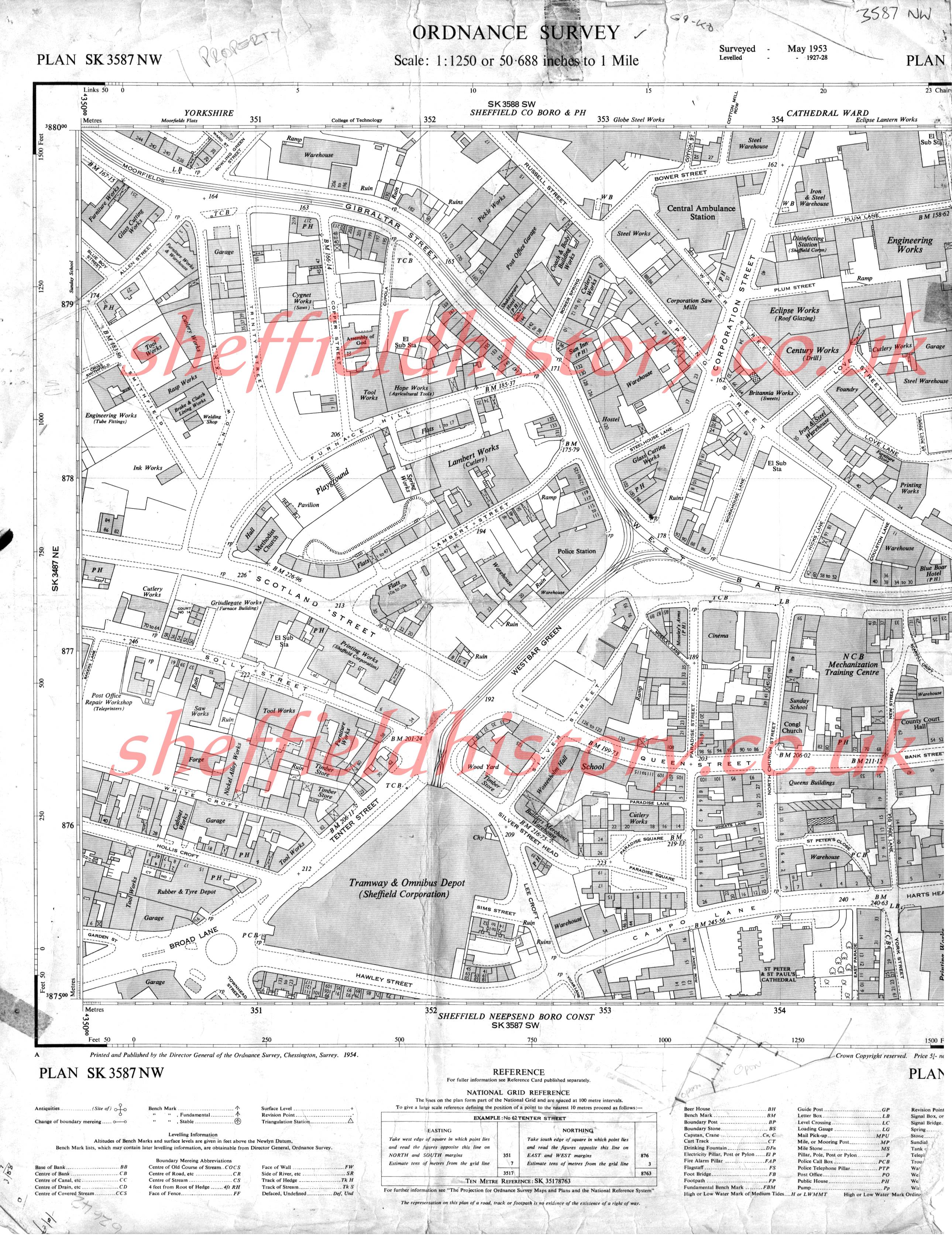
Os Maps Of Sheffield And District (1950's) - Over 300 Of Them !
SteveHB replied to RichardB's topic in Sheffield Maps
Map 3 - Gibraltar Street, West Bar, Campo Lane. Area © Crown Copyright 1954, Reproduced by kind permission of the Ordnance Survey SK3587NW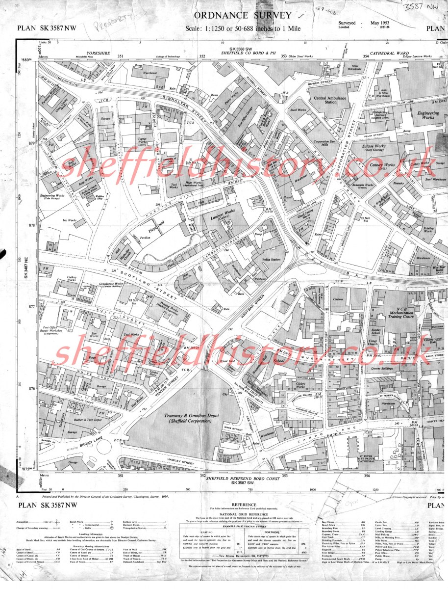
-

Os Maps Of Sheffield And District (1950's) - Over 300 Of Them !
RichardB posted a topic in Sheffield Maps
Google Interactive Map Click here to see a larger map Map Index of 1950's Ordnance Survey Maps Abbeydale 263 Abbeydale - 52 Abbeydale Park - 307 Aperknowle village -146 Archer Rd - 261 Area NW of Aperknowle - 331 Aston - 114 Attercliffe - 178 Attercliffe - 180 Attercliffe - 181 Attercliffe - 66 Attercliffe - 87 Attercliffe - 92 Attercliffe - 93 Attercliffe Common - 142 Attercliffe/Darnall - 183 Attercliffe/Hyde Park - 95 Attrercliffe - 94 Banner Cross - 202 Banner Cross - 205 Barlow area. - 49 Beauchief - 216 Bellhouse Road - 58 Bellhouse Road - 59 Bents Green - 302 Bents Green - 313 Birkendale - 237 Birley Car - 248 Birley Carr/Foxhill - 249 Botanical Gardens - 242 Botanical Gardens - 243 Bradway - 213 Bradway - 330 Bradway - 337 Bradway/Totley Rise - 212 Bridgehouses - 10 Brightside - 160 Brightside - 174 Brightside - 175 Brincliffe - 229 Brincliffe - 56 Brinsworth - 151 Brinsworth - 155 Broomhall - 273 Broomhall/City Centre - 271 Broomhill - 230 Broomhill - 232 Broomhill/Tapton - 207 Burbage (part of), Hathersage Rd - 326 Burncross - 38 Burngreave - 5 Burngreave - 86 Burngreave Road - 11 Carbrook - 176 Carbrook - 177 Carbrook - 179 Carlisle Street East - 64 Carterknowle - 57 Chancet Wood - 258 Chapeltown - 26 Chapeltown - 293 Charltonbrook / Burncross - 39 Charltonbrook / Burncross - 39 b Chesterfield (part of) - 74 City Centre - 1 City Centre - 2 City Centre - 272 City Centre - 4 Coal Aston village (part) - 101 Coming later - 303 Concorde Park - 148 Crookes - 219 Crookes - 235 Crookes/Broomhill - 186 Crookes/Walkley Bank - 187 Crookesmoor - 233 Crosspool - 208 Crosspool/Broomhill - 283 Dalton - 116 Damflask - 209 Darnall - 123 Darnall - 125 Darnall - 143 Darnall - 144 Darnall - 166 Darnall - 182 Darnall - 184 Darnall - 191 Deepcar / Old Haywoods - 328 Derbyshire Lane - 15 Derbyshire Lane - 45 Dore - 266 Dore - 278 Dore - 279 Dore - 309 Dore - 310 Dore - 311 Dore & Totley Station - 214 Dore Moor - 343 Dronfield - 41 Dronfield - 42 Dronfield (part of), Chesterfield Rd, - 325 Dronfield/Quoit Green - 43 Dronfield/Snape Hill - 44 Ecclesall - 203 Ecclesall Woods (part) - 215 Ecclesall Woods (part) - 217 Ecclesall/High Storrs - 204 Ecclesfield - 24 Ecclesfield - 25 Ecclesfield - 294 Ecclesfield - 332 Ecclesfield - 76 Ecclesfield / Shiregreen - 77 Firth Park - 147 Firth Park - 300 Firth Park - 81 Firth Park - 85 Firvale - 83 Firvale - 84 Folderings / Onesacre - 158 Frecheville - 170 Fulwood - 222 Fulwood/Goole Green - 281 Fulwood/Stumperlowe - 280 General Infirmary (Northern General) - 82 Gleadless - 124 Gleadless - 145 Gleadless Common - 105 Gleadless Rd - 73 Gleadless Townend - 128 Glossop Rd - 231 Greenhill - 225 Greenhill - 227 Greenhill - 254 Greenhill - 51 Greenhill, Meadowhead - 342 Grenoside - 251 Grenoside - 28 Grenoside North West of - 200 Greystones - 192 Greystones Cliffe - 292 Grimesthorpe - 60 Grimesthorpe - 63 Hackenthorpe Estate (part) - 132 Hackenthorpe Estate (part) - 163 Hackenthorpe old village - 133 Hackenthorpe South of - 298 Hallamhead - 286 Hallamhead - 320 Handsworth - 156 Handsworth - 159 Handsworth - 161 Handsworth//Darnall - 167 Handsworth/Darnall - 140 Harley Village - 75 Harthill village - 107 Heeley - 100 Heeley - 20 Heeley - 21 Heeley Green - 19 High Wincobank - 172 High Wincobank - 62 Highfields - 13 Highfields - 23 HighGreen - 253 Hill Foot Bridge - 31 Hillfoot - 33 Hillsborough - 195 Hillsborough - 196 Hillsborough - 211 Hillsborough - 239 Hillsborough - 241 Hillsborough - 244 Hillsborough Park - 246 Holmesfield South of - 277 Hoyland Common - 40 Hunters Bar - 228 Hurlfield - 70 Intake - 127 Intake - 168 Intake - 169 Jordanthorpe - 297 Killamarsh (part) - 118 Killamarsh (part) - 119 Kimberworth - 134 Kiveton Park (part) - 106 Lees Hall - 14 Longley Lane - 47 Low Wincobank - 126 Low Wincobank - 171 Lowedges / Batemoor - 327 Lower Bradway - 296 Lower Bradway - 50 Lower Walkley - 240 Loxley - 288 Malin Bridge (part) - 193 Malinn Bridge (part) - 194 Manor Estate (part) - 185 Manor Top - 104 Meadowhead - 255 Meersbrook - 17 Meersbrook - 264 MeersBrook - 71 Meersbrook Park - 190 Middlewood Hospital - 199 Middlewood/Beeley Wood - 340 Millhouses - 218 Millhouses - 53 Millhouses - 55 Millhouses Park - 54 Millhouses/Whirlowdale - 201 Millthorpe, Cordwell Ln. - 339 Mosbrough (part) - 103 Nether Edge - 262 Nether Edge/ Little London - 265 Nethergreen - 88 Netherthorpe - 109 Netherthorpe - 274 Netherthorpe/Walkley - 275 Norfolk Park - 97 Norfolk Park - 98 Normanton Springs - 162 North Anston - 322 Northern General Hospital - 138 Norton - 299 Norton Lees - 16 Norton Lees - 290 Norton Lees - 291 Norton/Meersbrook - 46 Orgreave - 153 Oughtibridge - 335 Owler Bar, Baslow Rd - 328 Owler Bar, Baslow Rd - 329 Owler Lane - 61 Owlerton - 238 Owlerton - 245 Park Hill - 96 Parkwood Springs - 32 Parson Cross - 22 Parson Cross - 34 Parson Cross - 35 Parson Cross - 36 Philadelphia - 29 Pirate Sheffield - 250 Pitsmoor - 8 Pitsmoor - 89 Pitsmoor - 90 Pitsmoor/Grimethorpe - 91 Plumbley village - 102 Queens Road - 12 Ranmoor - 206 Ranmoor - 210 Ranmoor - 284 Richmond, Stradbroke Rd - 341 Ridgeway (part) / Ford - 164 Ringinglow Rd, Limb Valley - 334 Ringinlow - 221 Rivelin - 287 Rivelin Valley Rd - 189 Roe Wood - 48 Roe Wood - 9 Rotherham Bradgate - 135 Rotherham Canklow and Ickles - 150 Rotherham Clifton Park - 120 Rotherham Hilltop - 165 Rotherham Holmes - 154 Rotherham Meadowbank - 137 Rotherham Morgate - 121 Rotherham Town Centre - 149 Rotherham, Warren Vale - 324 Rotherham. Whinney Hill, Doncaster Rd - 323 Salmon Pastures - 67 Salmon Pastures - 68 Sandygate - 285 Shalesmoor - 6 Sharrow - 226 Sharrow - 267 Sharrow - 268 Sharrow - 269 Sharrow - 270 Sharrowvale - 224 Sheffield and Tinsley Canal - 65 Sheffield Park - 69 Shirecliffe Rd - 333 Shiregreen - 301 Shiregreen - 78 Shiregreen - 79 Shiregreen / Firth Park - 80 Shiregreen Lane - 7 Sky Edge - 99 Sothall - 122 Spring Bank - 234 Stannington - 223 Stannington - 282 Stannington - 318 Stocksbridge, Deepcar - 344 Stocksbridge - Works, Garden Village, Stocksbridge - 345 Swallownest - 117 Swinton - 115 Thorncliffe - 27 Thorpe Salvin West of - 129 Tinsley - 136 Tinsley - 139 Tinsley - 141 Totley - 305 Totley - 306 Totley Rise - 308 Totley West of - 220 Totley, Baslow Rd - 336 Ulley village - 112 Ulley village South of - 113 Unstone Village - 72 Upperthorpe - 30 Wadsley Bridge - 247 Wadsley/Hillsborough - 198 Wadsley/Hollowmoor - 197 Wales - 108 Wales Court - 110 Wales village (part) - 111 Walkley - 236 Walkley Bank. Bole Hill Rd - 188 Well Road - 18 West Bar - 3 West of Grenoside - 252 Wharncliffe Side - 276 Wharncliffe Side - 317 Whirlow - 312 Whitley - 37 Whitley - 37 b Wincobank - 173 Wisewood - 314 Wisewood - 319 Wisewood/Wadsley - 316 Woodhouse - 130 Woodhouse / Beaverhill area - 157 Woodhouse Mill - 152 Woodhouse/Coisley Hill - 131 Woodseats - 256 Woodseats - 257 Woodseats - 259 Woodseats - 260 Worrall - 289 Worrall Village - 304 Worrall/Wadsley - 315 Wybourn - 295 Alphabetical_Maps.txt