Search the Community
Showing results for 'coal pit lane'.
-
Unidentified housing (1900's) Suggestions include Court on Granville Lane, however does not match maps. http://www.picturesheffield.com/cgi-bin/pi...ff.refno=s06056
-
I'm not great on the area; plus it was before I was born, begins with "M" and it's a Street, not a Road/Walk/Lane etc.
-
Carwood Lane/Terrace?
-
Extract : John Dodsley Webster (1840-1913) was much more typical of the unsung local architect than W. J. Hale. The scope of his work encompassed the whole range open to an architect: churches, public and commercial buildings, villas and small houses, additions and extensions. Capable of working in a variety of different styles at the behest of his clients, it would be unfair to compare his designs with those of the leading London-based architects. Nonetheless, he created well-crafted buildings appropriate to their settings, often on a limited budget. Webster's Churches : http://www.lookingatbuildings.org.uk/citie...s-churches.html Ranmoor Wesleyan (1870) St Paul, Norton Lees Lane (1875-7) Trinity Wesleyan Church, London Road (1879) St James, Retford Road, Woodhouse Mill (1892) Christ Church, Sheffield Road, Hackenthorpe (1899) St Augustine, Brocco Bank (1897) St Cuthbert, Fir Vale (1902-5) St Oswald, Abbeydale Road (1909-10) St Timothy, Slinn Street (1910-11) ------------------------------------------------------------------------------------------------------------------- Hospitals : http://www.lookingatbuildings.org.uk/citie.../hospitals.html Jessop Hospital for Women (1878) Medical School, Leopold Street (1888) additions to the Royal Infirmary for the Outpatients Department and Nurses Home Children's Hospital, Western Bank (1902) ------------------------------------------------------------------------------------------------------------------- Commercial : http://www.lookingatbuildings.org.uk/citie...commercial.html Davy's Shop, Fargate (1882) Bainbridge Buildings, Surrey Street (1884) St Paul's Parade (1898) ------------------------------------------------------------------------------------------------------------------- Housing : Many houses in Ranmoor during the busiest phase of its development in the 1870's West Lea (1870) Ranfall (1871) Italianate Lodge, Ranmoor Road (1874) Ranmoor Terrace, Fulwood Road (1876) Webster.bmp
-
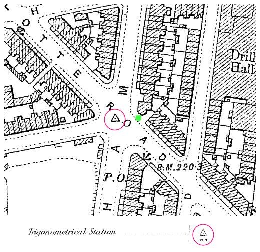
I have been studying the 1950's OS maps and have come up with a possible answer, the plate set in the pavement is a 'Ward boundary mark' EW= Eastern Ward? Don't think I've ever been through it or noticed it, come to that, but my guess is: that it's not very far from your last Mystery Location (STANCH) on Bailey Lane.
-
Free Writing School John Eadon Master Freewriting School Campo Lane Gales & Martin 1787 Job Cawood Free Writing School 14 School Croft White's 1833 Henry Kelvey Master, Boys Free Writing School School Croft Pigot's 1841 Henry Wild Free Writing Schoolmaster 20 School Croft White's 1852
-
Allotments off Hanover Street, looking towards Broomspring Lane, 1855-1860, photographed by Arthur Hayball from his house in Hanover Street (1850's photo) http://www.picturesheffield.com/cgi-bin/pi...ff.refno=y00521
-
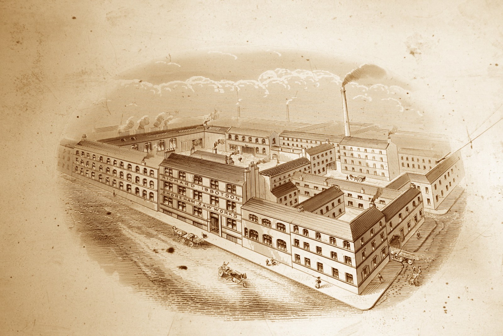
Hello everyone, I'm new to all this so hope I am posting this to the right place and that it is relevant! My 4x ggrandfather was a flaxdresser/farmer called Christopher Ibbotson, many of whose descendants were fairly prominent industrialists during Victorian times. I have collected large amounts of information about the various branches but am interested here in knowing whether anyone can provide any information about the attached photograph of a printer's plate: I bought it recently on ebay because Richard Ibbotson, Saw Maker, was one of my 4x great uncles. I know from trade directories that his factory was located for many years at "24 Norfolk lane & 183 Norfolk street". This was still the address in 1881, the year after he died. By 1905 the company (no longer in the family) was located at "Shoreham Works, White Croft". Apart from the attached, I have yet to find any photographs or prints of the factory and don't know whether the two locations above are one and the same and, if not, which one is represented in the picture? I would appreciate any information anyone may have to help me with this, Many thanks, John Ibbotson
-
A couple of wild guesses Jacob Cook Victualler 31 Burgess Street -- > Yorkshireman’s Arms Widow Goodlad Victualler 18 Paradise Square -- > Q in the Corner James Kay Innkeeper 1 Change Alley -- > Old King’s Head William Law Victualler 61 Trippet Lane -- > Dog and Partridge Ann Richardson Victualler 15 Paradise Square -- > Old Cock Jeremy
-
Red Hill John Eadon Schoolmaster Red Hill; h. Broad Lane, St George's White's 1833 ----------------------------------- Leader family tree anyone ? I, for one, would love to see it, no relation but a big part of true Sheffield history.
-
Shefield United play cricket at the old Firth Vickers sports ground on Bawtry Road. It is next to the Aurorar sports ground. It is a very extensive sports ground, on the right as you are going away from Tinsley and towards Brinsworth. Brilliant cricket ground! But the main ground is just one of several. Well worth a visit if you are interested in cricket. (They should still be playing at Bramall Lane, really, but the footie crowd on the board, forgetting it started as a cricket ground, kicked them out in 1973. Shame.)
-
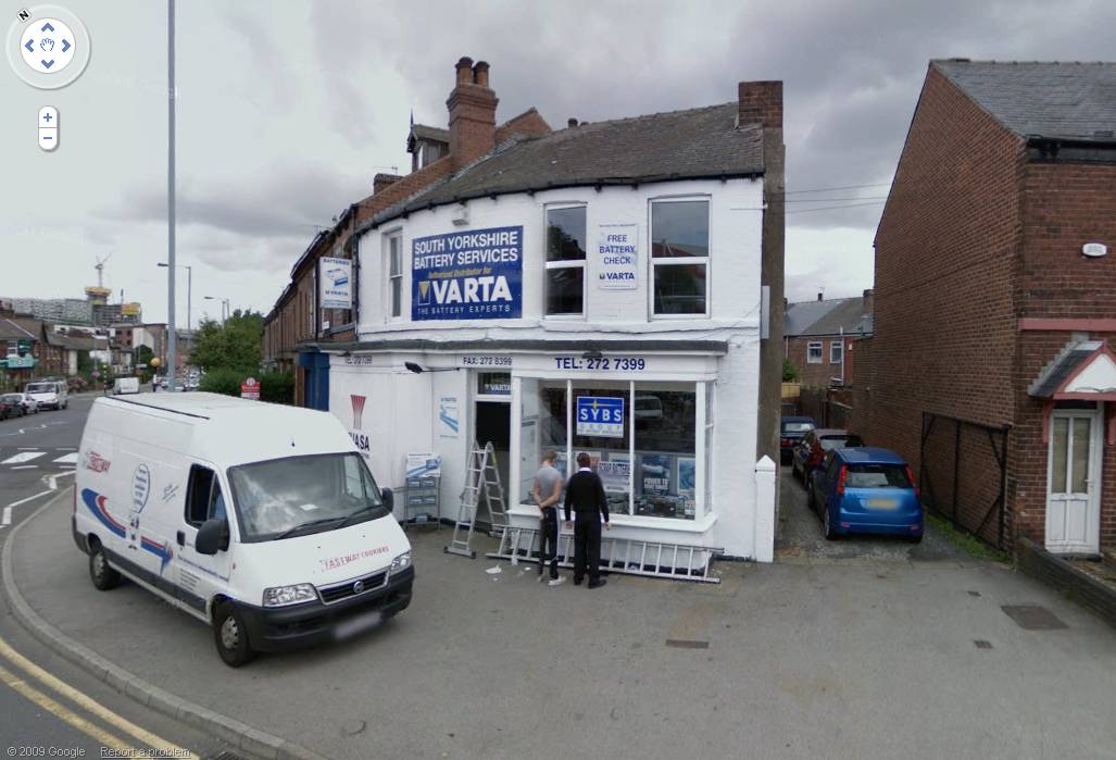
OK its NOT Brammall Lane its Shoreham Street, but the shop is actually on Charlotte Road Think this is the location.

-
Car batteries in the window Not that place on the corner of Charlotte Road and Brammall Lane then is it? Only shop I know with a window display of car batteries.
-

Sheffield Parks Recreation Grounds and Open Spaces
Stuart0742 replied to Stuart0742's topic in Sheffield History Chat
Wood Lane Countryside Centre Map Ref 87 -
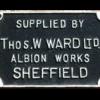
This is the Dog Brand trademark of J & Riley Carr Ltd the manufacturing company that occupied the building until the 1950's. The business was established by Riley Carr in 1806 in Bailey Lane but relocated to Herries Road South in 1954. Originally the company were concerned with merchanting steel and making steel and saw fenders but later manufactured saws, files and machine knives. The phrase "a stanch (or staunch) dog" means a good, reliable hunting dog. http://images.google.co.uk/imgres?imgurl=h...sa%3DN%26um%3D1
-
Map 23 shows Bramall Lane bus depot quite clearly, between the Olympic Sawmills and the Sheaf House Pub. http://www.sheffieldhistory.co.uk/forums/i...amp;#entry22507 It can be seen from the air in several photos on Picture Sheffield: the best is probably this one, where it is the large dark-roofed building. As far as I can tell, it became a transport depot in 1926 and closed in 1963, when East Bank garage was opened. The only photos I can find are in Sheffield Transport by Chas C Hall ( Transport Publishing Co, 1977, ISBN 0-903839-04-0). None of them shows much of the building, unfortunately.
-
The slag is from the Neepsend Power Station. (Picture Sheffield image) It spills over into the cemetery and may cover some graves. The slagheaps now have lots of landfill over them, They come right down to Club Mill Lane and cover the footpath leading to the 'subway'. There might be some sign of the subway the other side of the railway. Hugh
-
This has been mentioned in a post on Seffield Forum, I was one of the inspectors who used to work in campo Lane at the time, I remember six buses on the 51 route at that time, the Dennis of course, who no one had heard of in bus circles it has to be said, the M C W, a Leyland, I think named an Olympian, a Seddon which had very poor brakes, the Ailsa, which was radicaly different to all the others with it's front mounted engine, a Foden, which I remember little about, and they were "messing about" with the gas engine bus. I found the Dennis interesting because of it's choice of engine, the Rolls Royce Eagle, being a great fan of the famous RR aero engines I was suitably impressed, we normally saw new buses of different brands using Gardner engines, good and reliable, but very "plodding" engines. The Ailsa was pretty useless on the 51 route as it had a very slow acceleration, only speeding up as revs built, and the turbo kicked in, a bus needs to be able to get away from a stop smartish, top speed has no relevance. The gas engine bus was amazingly fast, almost like a car performance, but could only carry enough fuel for two trips, once again, a RR engine, a straight six converted from a Daimler scout car. The fact that the Dominator has given such a long and popular service probably points to the right choice being made when this was picked, it was a very controversial decision at the time, many and vociferous were the critics.
-
There was a Garage on this Street/Road/Lane?Boulevard (1950's) ... not that it helps much. It has a mention on PictureSheffield but hardly worth it, more like the "ghost of Mrs Miggins Road" than a useful image. It shows two buildings standing and the streets that ran either side in the distance, already part demolished.
-
Holme Lane/Loxley New Rd - near the tram terminus?
-
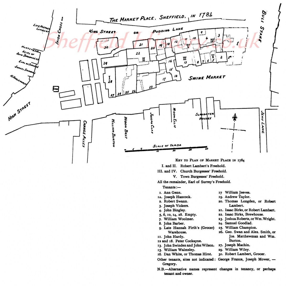
Market Place and Butchers Shambles in 1784 The accompanying plan will give a far better idea of the curiously irregular arrangement of the old market buildings and the surrounding streets. The lines of the numerous market tenements, and of King Street and the Fruit Market, show a survival of the happy-golucky indifference of the old days to symmetry, and of the manner in which houses were placed anyhow, according to the fancy of the builders and the long-suffering of their neighbours. The Market Cross stood at the top, not in the centre, but somewhat nearer to Change Alley than to King Street, and below it the wooden sheds or stalls of the butchers ran, some down, then others across. The shambles, most dismal, were then made of wood, The sheds of the stalls, almost closing amain, Form'd an archway for customers out of the rain ; Down the centre a channel, the filth to convey ; And some lighted candles, almost at midday. The more permanent erections, of all shapes and sizes, saleshops, workshops, houses, warehouses, brew-houses, and what not; occurred below them in the most promiscuous manner, now receding, now projecting, and occasionally separated by narrow passages. One block, the shop of Mr. Robert Lambert, grocer, at the north-west corner of King Street, stood boldly detached, with thoroughfares all round. Below it, the buildings on both sides of the present Shambles area trended east by north, making the bottom end of Pudding Lane (King Street)very narrow where it joined Bull Stake (Old Hay- market), While on the other (now Fitzalan Square) side, the buildings receded so far as to leave an open space used as the Swine Market, and opposite to this (afterwards Market Street) stood the gruesome slaughter-houses " a nuisance to all that pass'd by the place."
-

Other Maps/Plans/Layoutshttps://www.sheffieldhistory.co.uk/forums/topic/4458-other-mapsplanslayouts/
Guest replied to RichardB's topic in Sheffield Maps
That is a copy of the 1855 6in OS map to which has been added some of the field/plot numbers in the Wadsley Bridge area. I think these field/plot numbers were used on the larger scale map but omitted from the 6 in version for a cleaner impression, although they may not have been introduced until the 1890s survey. Some boundaries have also been overdrawn so it may have been used in connection with rating valuation etc. Edit to add that Leppings lane bridge was built in 1891 and widened from 22 feet to 45 feet in 1913.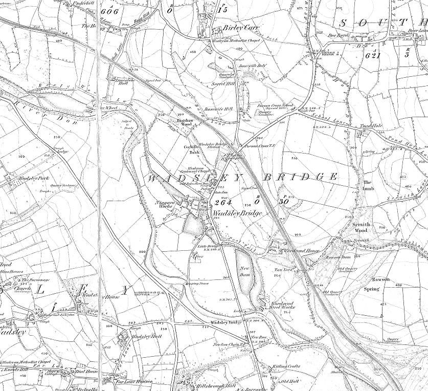
-
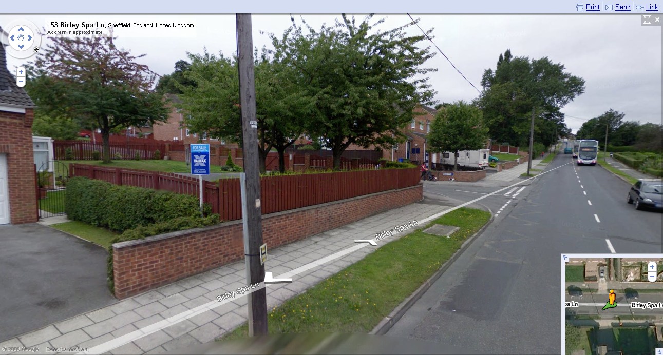
Rainbow Forge Primary School, technically this school has not closed, merely moved sites when Carter Lodge Comprehensive closed. Birley spa Lane
-
Sorry, Seems I was probably a bit out. I was going on hearsay. I worked at Atkinsons, (across the road from Brightside lane depot) for a while and that's what they referred to it as. According to UK Company records, your Stevenson Road location is the one. J.H.CHARLESWORTH Ltd Registered No. 00633957 ATTERCLIFFE GOODS DEPOT, STEVENSON RD., SHEFFIELD., S9 3XG
-
I can more accurately place a few of the hits. For instance the Derbyshire Lane one, Tavistock Road, and some others, all of which relate to my family. For a mad moment I thought of using the 50's map to place my "deffinites" and move others which are obviously wrongly placed to more likely places recorded as ruins on the 50's map. Also I've visited a few "Hit Sites" and found evidence of missing buildings, and obvious damage/repair work. Not 100% proof but very likely. It then dawned on me what a massive undertaking that would be and shelved the idea. Maybe after I retire. (If I ever do. I'm one of those ill advised pension scheme victimes) Anyway someone may have already done it on Richard's map. I don't know if the map Richard has is more accurate, he doesn't say.