Search the Community
Showing results for 'coal pit lane'.
-

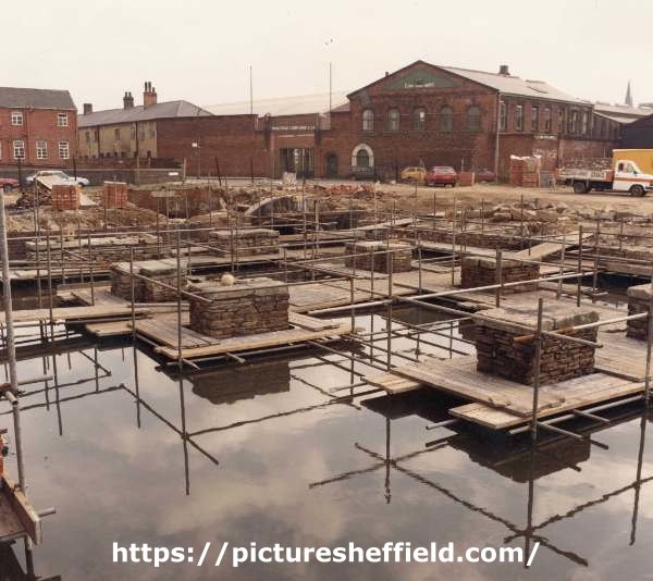
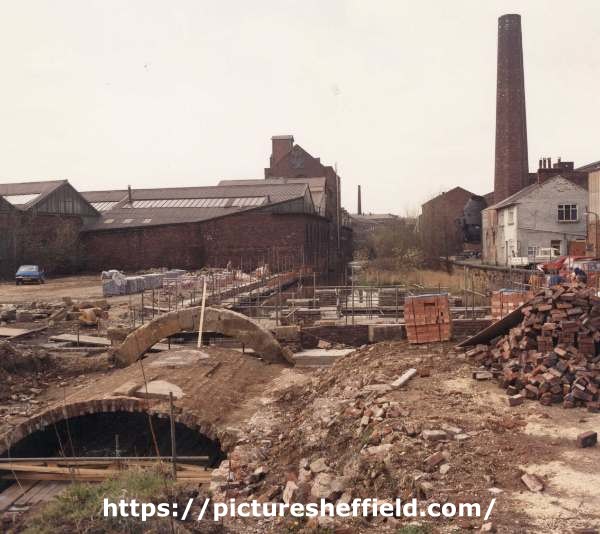
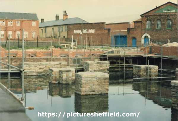
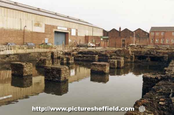
New Era Square off London Road - what used to be there?
Ponytail replied to Sheffield History's topic in Sheffield History Chat
Area around New Era Square in earlier times showing proposed streets. Note some streets changed names. Little Sheffield (London Road) Completed layout of the streets in Rowland Hodgson's land, c. 1818. https://www.picturesheffield.com/frontend.php?keywords=Ref_No_increment;EQUALS;arc04154&pos=17&action=zoom&id=104100 Marked: William Stratford, William Cooper, Samuel Johnson, James Richardson, Samuel Mather, William Staley, Henry Lester, John Reaney, Thomas Burton, Henry Hewitt, John Cadman, Thomas Hounsfield, George Carnall, William Flockton, Catherine Younger, William Staley, Robert Marples, Jackson Frow, Michael Butler, David Craven, William Bunting, John and William Bridgens, Thomas Booker, T. Worstenholme, James Bowen or Bower, Robert Green, William Steadman, John Webster, William Cooper, William Beardstall?, Roger Brown and Sons, Jos. Garlick, George Turton, John Richardson, William Ashall, James Merryweather, George Hall, Jno. Gallimore, Joseph Bower, John Jackson, Joseph Hutchinson, Machin and Hall, Jos. Priest, William Hallewell, Young Sick Society, George Wild, Samuel Rogers, John Wright, William Roper, John Shead, Charles Gallimore, John Mayman, John Hewitt, Robert Walker, Joseph Twells, Joseph Bower, and Jno. Sheldon. Also Marked: River Porter, Little Sheffield; Hermitage Streeet; George Street; Clinton Street. Plan of the late Thomas Booker's leasehold. Properties in the streets between London Road and Brammall Lane (sic) Not dated. https://www.picturesheffield.com/frontend.php?keywords=Ref_No_increment;EQUALS;arc04152&pos=89&action=zoom&id=104092 Shows: Turnpike Road [London Road], Hermitage Street, Clinton Street, George Street, Sheldon Street, Thomas Street, John Street, and Brammall Lane [Bramall Lane]. Refers to the late Rowland Hodgson and the late John Sheldon. Land measured for Rowland Hodgson, with new streets laid out - Hermitage Street, George Street (now Boston Street) and George Lane, 1817. https://www.picturesheffield.com/frontend.php?keywords=Ref_No_increment;EQUALS;arc04153&pos=1&action=zoom&id=104099 Marked: 1 Samuel Newbould, 2 Samuel Johnson, 3 and 4 Thomas Jacklin, 5 Jonathan Crookes, 6 Jonathan Sherwood, 7 William Needham, 8 Thomas Worstenholm, 9 William Brown and George Carnall; also shows William Smith and Rowland Hodgson's gardens; and River Porter. Also: White House Lane (Bramall Lane) Plan of part of the land of the late John Sheldon between George Street and Sheldon Street showing several encroachment. 1843 https://www.picturesheffield.com/frontend.php?keywords=Ref_No_increment;EQUALS;arc04246&pos=95&action=zoom&id=105406 Marked: George Street, Sheldon Street, and Clinton Street; Joseph Prince, William Hallewell, late George Wild now - Webster, late John Wright now Henry Broomhead, late John Sheard? [now?] Michael Butler, Charles Gallimore, John Maynam, and late Mr Sheldon's land. A survey of several closes (in their present state) belonging to the heirs of Samuel Sheldon [London Road] 1791. https://www.picturesheffield.com/frontend.php?keywords=Ref_No_increment;EQUALS;arc03639&pos=31&action=zoom&id=99190 Marked: Turnpike Road from Chesterfield. Plan of a lot of ground in Sheldon Street intended to be taken for a school. 1838. Marked: Sheldon Street; Clinton Street. https://www.picturesheffield.com/frontend.php?keywords=Ref_No_increment;EQUALS;arc03744&pos=11&action=zoom&id=99357 -
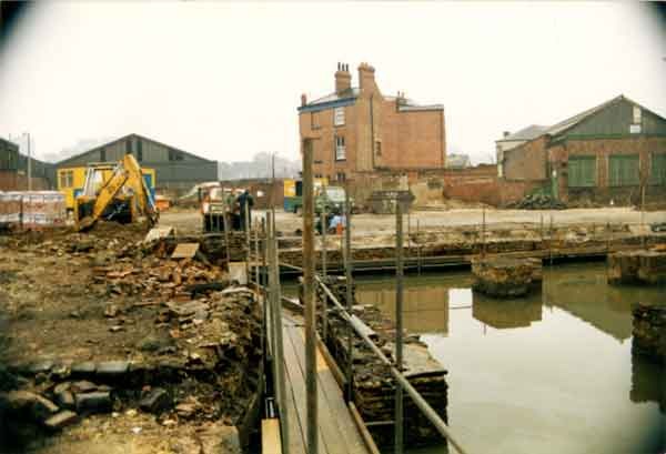
New Era Square off London Road - what used to be there?
Ponytail replied to Sheffield History's topic in Sheffield History Chat
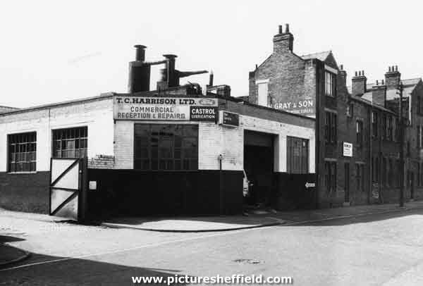
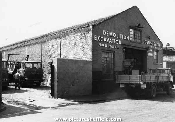
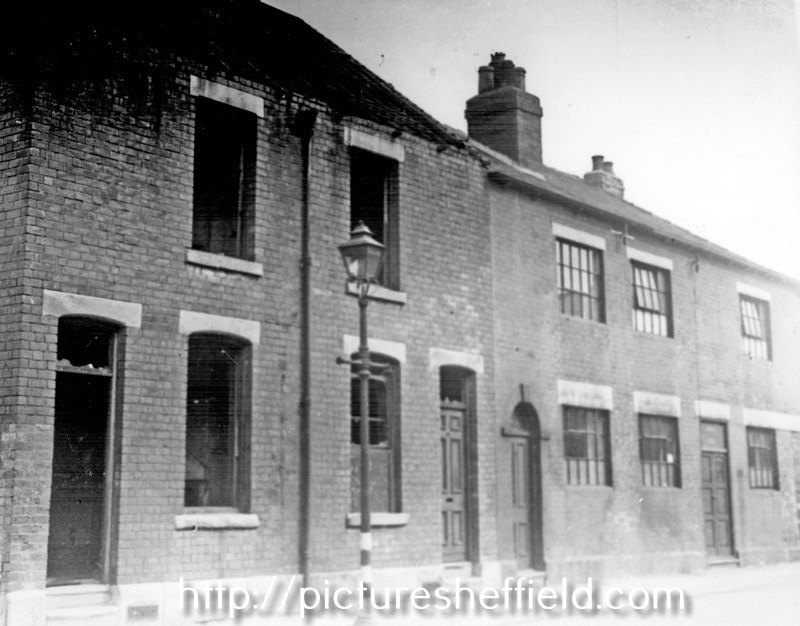
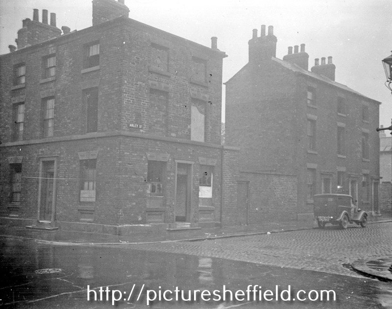
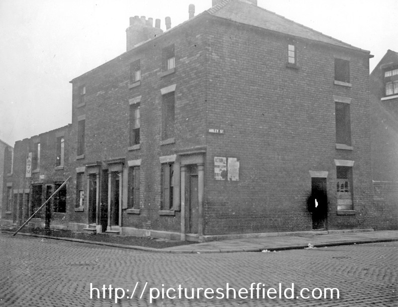
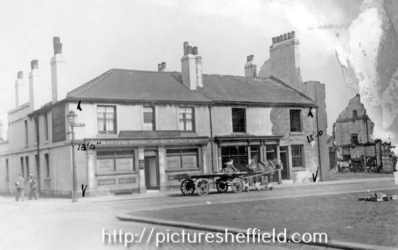
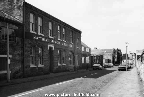
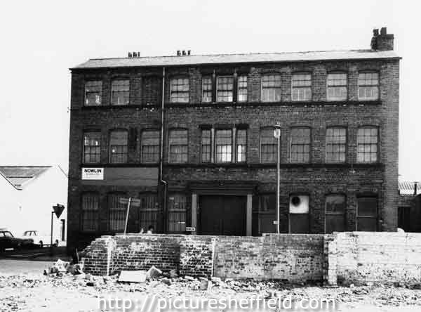
Derelict properties, Denby Street (formerly New Thomas Street) and Arley Street junction. 1937. s14851 Estates Surveyors Dept Nos 18-22, George Lane, Highfield looking towards Arley Street junction. Court Nos 3 and 5 at rear of these properties. September 1938.s16228 Estates Surveyors Dept. Nos 3-7, Arley Street (formerly Cross George Street) at junction of Nos 49-51, Hermitage Street. September 1938. s13025 Nos 17-23, Arley Street at junction of Sheldon Street. Nos 21-23, August 1943. Premises of Philip Sunderland, Silver Plater. Court No. 9 (Boston Street) at rear of houses on left. 23 Arley Street was the Grey Horse Inn. u00962 City Engineers Dept. Angler's Rest, No 50, Boston Street (formerly New George Street), at junction of Arley Street. Nos 44-46, prior to demolition, right. Back to back houses already demolished. August 1939. u02480 Estates Surveyors Dept T.C. Harrison, commercial vehicle repairers, Arley Street. May 1975. s34864 Joseph Smith (Sheffield) Ltd, haulage, demolition and plant hire, Arley Street frontage. May 1975.s34840 Matthias Spencer and Sons Ltd, mining machinery manufacturers, Arley Street. May 1975.s34863 H. L. Nowlin and Son Ltd, surgical instrument manufacturers, Boston Street at the junction with Arley Street. May 1975.s38017 See Picture Sheffield for more images of the area. https://www.picturesheffield.com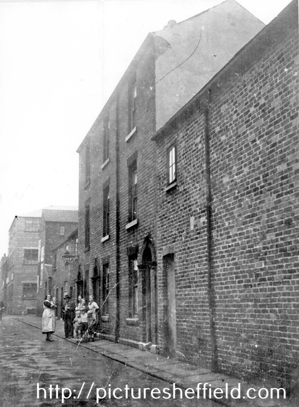
-

New Era Square off London Road - what used to be there?
southside replied to Sheffield History's topic in Sheffield History Chat
Wasn't Denby Street somewhere in that location? I remember meeting some mates in a pub on Denby Street on the way to the Lane in the early 60s. -
The Ringinglow Estate, the property of the late Thomas Rawson, 1827. https://www.picturesheffield.com/frontend.php?keywords=Ref_No_increment;EQUALS;arc03946&pos=1&action=zoom&id=101954 Git Mottram: 1. Rough Smeltings and Croft, 2. House and garden, 3. Upper Smeltings, 4. Lower Smeltings. In hand, 5. New planting, 6. Bank plantation, 7 and 8. plantations, 9. Weigh house, 10. Rough plantation toll house and part cultivated, 11. Stack Garth Plantation, 12 - 14. Plantations, 15. Upper Lumb, 16. Lower Lumb, 17. Plantation adjoining Porter Brook. 18. plantation in Angram Lane. Richard Whitworth 19. Ringinglow Inn [later the Norfolk Arms], homestead, out buildings, yard and garden, 20. Stack Garth, 21. House Field, 22. Upper Planting field, 23. Cow Pasture, 24. Lamb Field, 25. Low Rye Field, 26. Rye Field. 27. Horse Pasture, 28. The Rough Banks; James Creswick, 29. Bottoms, 30. Well Bank, 31. Well Field, 32. Middle Common Piece, 33. Four Acre, 34. Barley Field, 35. Wiggin Field, 36. Bennet Field and Calf Croft, 37. Anise Field, 38. Planting Field, 39. Croft, 40. Homestead, house etc., 41. Old Field; Benjamin Fox, 42. Bank., 43. [black], 44. Broomhead Field, 45. Pingle. Thomas Watson, 46. Allotment. Also shows Colliery, road from Grindleford Bridge [Sheephill Lane], Ringinglow Road, Barber Fields, road to Fulwood [Fulwood Lane], site of [Norfolk Arms], [toll house], house field, Angram Lane, road to Birks Green and road from Bower Hill [Cottage Lane?].
-
Interestingly the Dyson brothers, Joseph and James crossed the paths of history in later life - in 1864 thanks to the Sheffield flood. The 2 brothers hailed from Thurgoland and in 1864 they were both employed at a wireworks on Bradfield Road, Hillsborough. Joseph (the manager there) and his family lived in Brick Row, Holme Lane where James lodged during the week while his family lived in Thurgoland. On the night of Friday March 10 / 11 the Dale Dike dam at Bradfield burst and the flood killed over 200 people in the Sheffield area. The flood destroyed Brick Row and Joseph and most of his family were killed - one child was away that night and survived - but James escaped by breaking through the roof and he escaped and was reunited with his own family a couple of days later - his wife had come by train to Sheffield to try and find him and he caught the train back home! My partner is James’s g-g-granddaughter and every time we go into the Norfolk Arms we think of him, his relatives and their experiences of that terrible night.
-
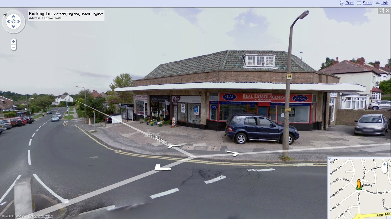
Butchers shown is number 147, the 1965 directory lists that whole building as S&E Co op Ltd., (no street number) the house to the left in the photograph, is number 141 Bocking Lane. Something has changed?
-
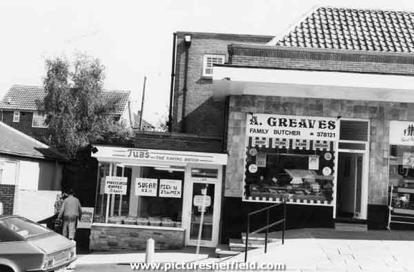
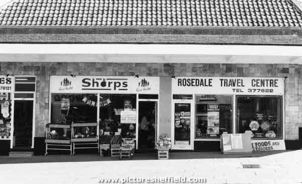
Bocking Lane. Not sure which of the above shops was the Co-op Shop or were they all Co-op at one time. Shops on Bocking Lane, Greenhill showing Tubs, grocers and A. Greaves, Butchers. 1987. s35231 Sharps, greengrocers and florist and Rosedale Travel Centre. 1987. s35232
-
Judging by this previous thread on SH about Co-Op’s, the Bocking Lane branch doesn’t look anything like the photo???
-
Thank you very much Stenner, I don't know the area at all and other photographs aren't helping to confirm. Does anybody have any photographs of the shops on Bocking Lane? Or can see what it is over the doorway? I only have a mobile phone to work with.
-
This looks very much like the S&E Coop that was in Greenhill village, top of Bocking Lane just before the roundabout - I used to live on Lowedges at that time and for a short time went to the school on the other section of the roundabout (the school on Lowedges Road hadn't been finished at the time - that must have been about 1954/5)
-
A plan of Hemmingway Farm near Sheffield: the property of the Duke of Norfolk, and now or late under Lease to Isaac Nodder. 1764. Surveyor: William Fairbank II. https://www.picturesheffield.com/frontend.php?keywords=Ref_No_increment;EQUALS;arc03391&pos=213&action=zoom&id=98630 Fields between Cricket Inn Road and (modern Blast Lane), with the wheel and dam (Park Furnace) and part of the Coal-pit sough; Numerical list with field names and descriptions and acreages. Park Furnace and the Simon Wheel (the works on the south side of the River Don from the junction with the Sheaf to modern Leveson Street) (Lumley Street, Sussex Street, Effingham Road, Effingham Street) Also marked: Park Hill; Joseph Clay's Farm; Thomas Bridges's Farm; John Waites's Farm. Does anybody have any information about Hemmingway Farm? Did it have another name? When did it disappear?
-
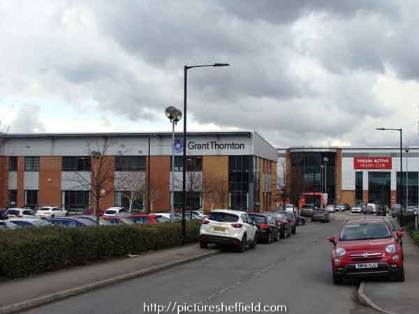
A Plan of George Hobson's Mill, Mill Dam, Weir, etc. at Heeley and of the contiguous parts of Benjamin Roebuck's Estate with description of other adjacent lands and part of Heeley, by William Fairbank. 1770. https://www.picturesheffield.com/frontend.php?keywords=Ref_No_increment;EQUALS;arc00462&pos=10&action=zoom&id=56556 Shown on the map are: River Sheaf, Little London Lane, Far Meadow, Nearer Meadow, Taylor's Grinding Wheel, Turnpike Road from Derby to Sheffield [Chesterfield Road], a Toll bar [?Heeley Toll Bar at the bottom of Albert Road] and lands of Joshua Spooner, Samuel Shore, Jonathan Wainwright, Benjamin Roebuck and William Haworth. It is believed the present day location of this area is near to 300 Broadfield Road Park, Broadfield Road, S8 0XQ. Grant Thornton, accountants and financial and management services, Unit 2 Broadfield Court showing (right) Virgin Active No.300 Broadfield Park, Broadfield Road. 2018. a04101 Photographer: Andrew Milroy.
-

Do you know my family? Swindells / Anderson / Johnson
SteveHB replied to BMJ214's topic in Sheffield Genealogy
Court 2, Harmer Lane https://maps.nls.uk/geo/explore/side-by-side/#zoom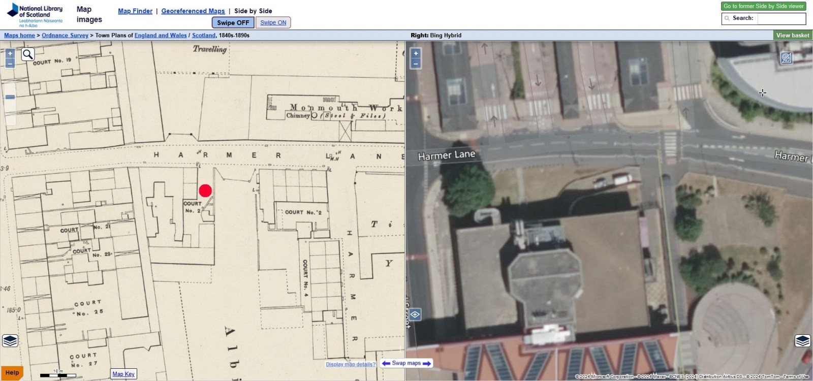
-
Do you know my family? Swindells / Anderson / Johnson
BMJ214 replied to BMJ214's topic in Sheffield Genealogy
Hi. I’m hoping someone can help me. I’ve come across a couple of addresses on Ancestry that I’m unsure about. 1. Philadelphia House, Ecclesall - 2. Tacna - 3. Harmer Lane (2 cut 1 house) 4. Fair View, Bamford Thanks in advance. -
Unidentified House & Road. Bounty Lane written on back of photograph but unable to find this location. t02554
-
Footpath leading to Parkbank Wood at Beauchief
Ponytail replied to Roger Stevenson's topic in Sheffield History Chat
Don't know how I missed this one. Abbey Dale. 1857 ov00161 Published April 20th 1857 by Wm. Ibbitt, 152 Broad Lane, Sheffield. Day and Son, lithographers to the Queen. Inscription on image reads: Respectfully inscribed to John Rodgers Esq. of Abbey Dale by his faithful servant William Ibbitt.
-
Plan of Freehold Land at Upperthorpe and an estate at Hollins, near Malin Bridge, in the hamlet of Stannington belonging to the trustees of the will of the late Thomas Blake, esquire. 1869. https://www.picturesheffield.com/frontend.php?keywords=Ref_No_increment;EQUALS;y12220&pos=3&action=zoom&id=81601 Upperthorpe: Lot 1. Four newly built dwelling houses situate at the foot of Blake Street .. in the occupation of Messrs Hemingway, Townsend, Clayton and Pechy, ... these houses are very well built and finished, and offer a most eligible investment. Lots 2. Plot of building ground with a good frontage to Blake Street. Lots 3. Building plot also fronting Blake Street. Lot 4. Plot of building ground on the opposite, or north east side of Blake Street. Lot 5. Ten freehold ground rents (the original particulars list the lessees'. Hollins: Lot 6. Farm house, outbuildings and garden ... at Hollins in the occupation of Benjamin Slack. Lot 7. Grass land known as Near Back Field. Lot 8. Grass lands known as Far Back Field. Lot 9. Land called Hollins Bottom, fronting Spooner's Wheel Lane. Lot 10. Land called Middle Hollins and land called Upper Hollins, both fronting Hollins Road. Original at Sheffield Local Studies Library: Sale Plans 9 March 1869.
-
Many local steelworks had their own barges. Tinsley Rolling Mills brought coal to the works on their own craft until , I believe, the 1920s. One was wrecked and it’s remains could be seen when the River Don was in low water. One of the companies long serving workman, Darkie Hercock ,was actually born on one of the Companies barges.
-
It looks to me like something put out by the Canal companies about the impact of railways on their business. However, I would take the rail figures with a pinch of salt. As we know, the Railways slaughtered the canal traffic and the cost by rail and being cheaper was enough for them to get scared of this new method of transport. With something like that document, you have to take in the motives of who would pay for the expense of publishing it. The document does say "probable" costs. It might be something to do with the canal interests trying to stop Coal Companies actually backing or investing in future rail developments! Showing they wouldn't save much on the short distances and loose on the long ones. There was often some strong opposition to rail expansion.
-
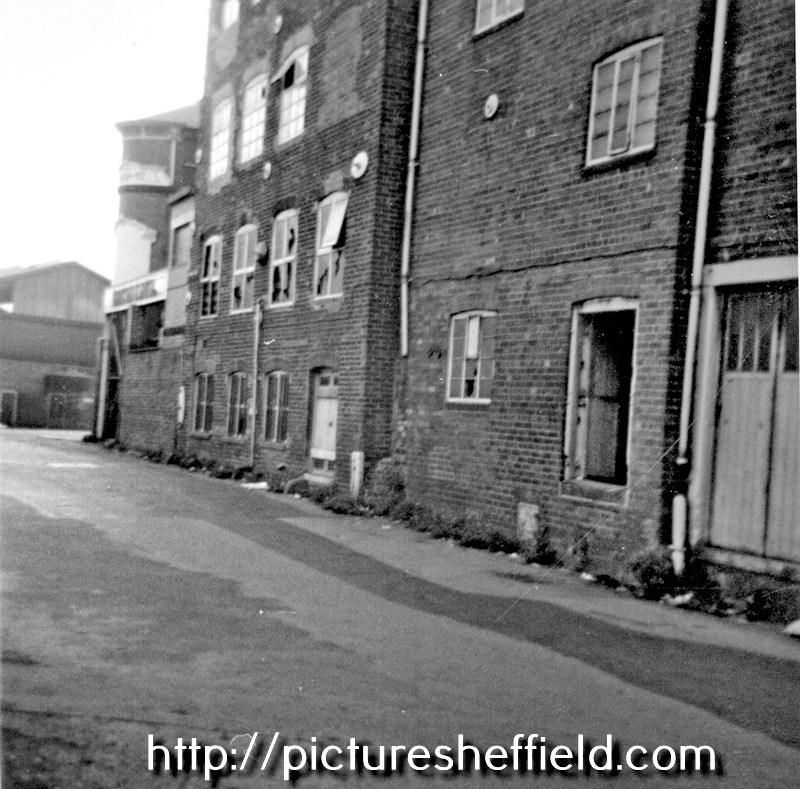
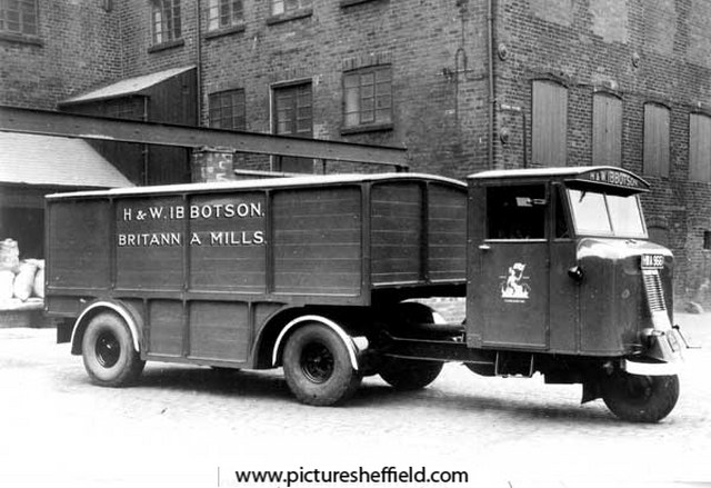
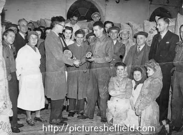
Britannia Mills 1879, 1901 & 1905 White's Directories H & W, Ibbotson, corn millers & corn merchants, Britannia Corn Mills, Alma Street & No. 19 (1901) 44 (1905) Corn Exchange. 1879, Henry and William Ibbotson living at Somerset Villa, 57 Burngreave Road. 1901, Henry and William Ibbotson, corn millers living at Shirecliffe House, 108 Shirecliffe Lane. 1905, Charles; Henry D; William, corn millers & Susan Ann Ibbotson living Shirecliffe House, 108 Shirecliffe Lane. Morning Telegraph Obituary Index. Henry Ibbotson of Britannia Corn Mills 27th December 1903 Henry Davis Ibbotson of H & W Ibbotson, Britannia Flour Mills 29th November 1930. H. and W. Ibbotson, Britannia Mills, corn millers, Alma Street, Kelham Island. t03724 Lorry belonging to H and W Ibbotson, corn millers of Alma Street, Kelham Island. t07661 Photograph from records of the Hallamshire Tyre and Motor Company at Sheffield Archives. Registration no. HWA 996. Presentation to the foreman, Mr. Johns who was leaving to take up a position at another mill. Part of caption on reverse reads: 'all office and work people together'. u10814 Extreme back (in arch with cap on) Aaron Rianowski? (original is difficult to decipher) Ibbotson's Boundary Line Plaque, Kelham Island, September 1978. w01425 Photographer David Cathels.
.jpg.6d51ac02997701b3a8ae404e39d22051.jpg)
-
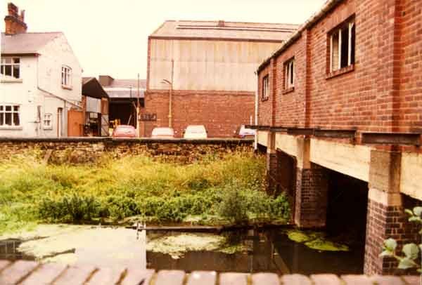
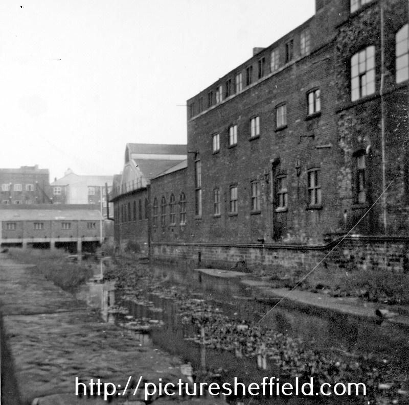
A plan of 1751 refers to the Mill Dam at Kellam Wheel as Clayton Dam. A map of part of the Close in William Aldam's possession proposed to be taken into the Lane near Clayton Damm containing 166 superficial yards, with the lane, etc adjoining. 1751. https://www.picturesheffield.com/frontend.php?keywords=Ref_No_increment;EQUALS;arc03303&pos=16&action=zoom&id=98496 A simple plan including only the cartway and additions, a footway, a potato-piece and the Butts in Clayton Dam. Kelham / Kellam Wheel, also known as the Clayton Dam; this was on the River Don near Green Lane. Kelham Wheel The name derived from Kellam Homer, the town armourer, who along with George Smedley and John Swyfte were, in 1604 the earliest recorded tenants of the grinding wheel positioned on the head goit to the Town Corn Mill on the land of Earl of Shrewsbury. From the Court Leet of 1609, the tenants of the grinding wheel were required to open the by-pass goit when their wheel wasn't working to ensure a supply of water to the Town Mill. Tenants recorded: 1637; 1641 George Smedley & John Swyfte. 1650 & 1654 recorded as destroyed. 1664-1695, Kellam Homers' son, Kenhelm followed by his wife. 1701 & 1704, Mrs Whatmoore. 1715, James Crawshaw, 21year lease with a rent of £15 had to rebuild the wheel and also ensure the water supply to the Town Corn Mill. A series of repairs from 1712 in the Woodwards accounts suggests major rebuilding. 1736, Walter Briddon on behalf of Johanna Crawshaw. The wheel had two ends of 6 and 5 troughs. Goslings Map 1736 the wheel is shown built across the race. 1758, Mary Briddon was paying £30 rent for 8 and 7 troughs. 1760, William Bower the silk mill builder. The Earl of Surrey’s tenements in Long Croft, Gibraltar [Street] and Bower Springs. 1782 The names of a later date have been added by Josiah Fairbank, and the line of Russell Street and Green Lane, and Bowling Green Street, added. Tenants named. Kelham Wheel marked. https://www.picturesheffield.com/frontend.php?keywords=Ref_No_increment;EQUALS;arc04123&pos=12&action=zoom&id=103838 Spring Street. Colson Crofts measured for the Duke of Norfolk, including the Cotton Mill, the Stream Engine Grinding Wheel, and T Holy’s land laid out in streets, 1805 https://www.picturesheffield.com/frontend.php?keywords=Ref_No_increment;EQUALS;arc04089&pos=6&action=zoom&id=103413 Shows: Cotton Mill Co., goight to footbridge, Cotton Street, Bower Street, north side of an ancient cut of fish pond, Spring Street, Water Street, Pear Street, Plum Street, Love Street, Engine Street (changed to Steam Street) and steam engine grinding wheels. For more information regarding The Silk and Cotton Mill see separate post: "Cotton Mill Co., Cotton Street" Kelham Street. The Cotton Factory, the Cotton Mill (formerly Kelham Wheel) etc in lots for sale, 1815. https://www.picturesheffield.com/frontend.php?keywords=Ref_No_increment;EQUALS;arc04087&pos=11&action=zoom&id=103381 1815, after a fire 1810 the freehold was sold, the larger of the two Cotton Mills became the Workhouse in 1828 and the smaller water powered Mill converted from the Kelham grinding wheel, also housed a 20hp Bolton and Watt steam engine, reverted to its original grinding use. 1822; 1828 & 1833 occupied by John Parkin, pen & pocket knife maker. John Parkin & Company https://hawleysheffieldknives.com/n-fulldetails.php?val=p&kel=2240 1835, 1837/8 Thomas Dunn of Dunn Wheel Co. A plan of a piece of land agreed to be purchased by Messrs Peace of Thomas Dunn. Land at edge of Kelham Wheel, 1837-1844. Shows Kelham Wheel Dam. https://www.picturesheffield.com/frontend.php?keywords=Ref_No_increment;EQUALS;arc03643&pos=9&action=zoom&id=99194 1841 and 1850 Directories record John Pearson, a wood turner and circular sawyer. 1845 Rate Book records Dunn had bought the wheel and it was he as owner who made the Flood Claim in 1864 when the goits were not too seriously damaged. Thomas Dunn, coal owner of Richmond Hill, Sheffield, claimed for damage to Kelham Wheel, Dam & Sluice. https://sheffieldfloodclaimsarchive.shu.ac.uk/claimSummary.cfm?claim=6-5362 After the Flood, the Wheel converted to a Corn Mill and was operated in 1875 by owner James Crossland and William Smith. 1879 White's Directory H & W, Ibbotson, corn millers & corn merchants, Britannia Corn Mills, Alma Street & Corn Exchange. Alma Street. Plan of Kellam Cottage and land adjoining as divided into lots for sale. No date. https://www.picturesheffield.com/frontend.php?keywords=Ref_No_increment;EQUALS;arc04159&pos=14&action=zoom&id=104122 Marked: Marked: River Dun [River Don], Kellam Wheel Goight [Kelham Wheel Goight], Green Lane, shuttles, Kellam Wheel [Kelham Wheel], wash, Kellam Cottage [Kelham Cottage]. Tenants / owners: John Yealdon / Yeadon, John Crowley, Emmanuel Pearson, George Hattersley, James Armitage, William Charles, John Charles, William Charles junior and Henry Travis. Ordnance Survey Map 1890 (294.8.6) shows buildings astride the goit and named Britannia Corn Mills (top of map).The buildings were demolished 1975 but the nine stone piers are still visible. https://www.picturesheffield.com/frontend.php?keywords=Ref_No_increment;EQUALS;q00077&pos=1&action=zoom&id=108114 Water still flows from the shuttles at the head goit into the side race culvert, that formerly fed the silk and cotton mill was still being used for cooling in the rolling mill at Apollo Steels until 1986*. Nothing remains of the main Cotton Mill but traces of ancillary buildings in Globe Steel Works, Alma Street. Kelham tail goit is culverted beneath Alma Street and the outfall to the River Don, Nursery Street. * Information from: "Water Power on the Sheffield Rivers" edited by David Crossley with Jean Cass, Neville Flavell & Colin Turner. W.A. Tyzack and Sons Co. Ltd., Horsemans Works, Alma Street looking across the Mill Race from Kelham Island. t03710 Entrance to Kelham Island showing the rear of the Britannia Corn Mills. t07951 Kelham Island remains of the Britannia Mill and Mill Race. https://www.picturesheffield.com/frontend.php?keywords=Ref_No_increment;EQUALS;u04111&pos=1&action=zoom&id=39621 Redevelopment of Kelham Island showing (background) the Fat Cat public house, No. 23 Alma Street t07955 Renovation work, Kelham Island showing (centre) Woodhead Components Ltd. and the Globe Steel Works, Alma Street. 1987 u12859 u12858 Renovation work, Kelham Island showing (back) Richardson Sheffield Ltd., cutlery manufacturers and Globe Steel Works, Alma Street. t14243 t08050 Renovated bridge, Kelham Island with Kelham Island Museum in background (right) t08039 Kelham Wheel. https://sheffielder.net/tag/kelham-wheel/
-
Not always. Many collieries had their own staithes, but then other collieries had rail loading facilities. Wagons are often shunted and spend time in sidings awaiting the next train, boats keep going. Large consumers or merchants may have a private basin, then again they may have a rail connection. You'd need to know the detailed provision for each trip to get an idea of speed. The document is dated 1800-1850, but the start date is way too early, the S&D opened in 1825 and the L&M five years later so what the earliest rail to Sheffield was I don't know. At that early date what speed did railways operate at? Finally, coal does not deteriorate in the timescales we are talking about so does speed matter at all? 30 miles is a day's canal journey, but then add lockage time, may be a couple of days.
-
A Statement of the probable cost of the carrying Coal along several Railways compared with the River Dun Navigation and the Canals connected with it. https://www.picturesheffield.com/frontend.php?keywords=Ref_No_increment;EQUALS;arc07567&pos=81&action=zoom&id=154933 Printed by G. Ridge, Sheffield, no date. Refers to Mr Chambers' Coal, Earl Fitzwilliam's Coal, Silkstone Coal, and Lord Fitzwilliam's Coal.
-
Thought these images from Picture Sheffield may be of interest and jog a few memories. Mr. Hill features in some of the Staff photographs. Myers Grove Secondary School, Wood Lane, Stannington, 17th December 1964, later renamed Forge Valley Community School. https://www.picturesheffield.com/frontend.php?keywords=Ref_No_increment;EQUALS;s31116&pos=7&action=zoom&id=64165 18th February 1975. https://www.picturesheffield.com/frontend.php?keywords=Ref_No_increment;EQUALS;s31117&pos=8&action=zoom&id=64166 Was there a connection with Sheffield Rugby Union FC to Myers Grove School? This newspaper report from 1966 probably gives a clue as to why Rugby was so keenly followed. As was always the case in those days, depended on the PE teacher as to the sport preference https://www.picturesheffield.com/frontend.php?keywords=Ref_No_increment;EQUALS;s28748&pos=3&action=zoom&id=51627 Caption with the photograph, Sheffield Rugby Club's key to success, indoor training at Myers Grove Comprehensive School. wee pipe Pearson, (left) evades Clive Standring after taking a pass from Bob Wall as the backs swing into action. See Sheffield Morning Telegraph Friday 4th February 1966. Staff at Myers Grove Secondary School? Date possibly 1960/70'st08169 Left to right: Peter Jackson, Don Flockton, Doug Sawyer, Unknown, Unknown, Unknown, Doug Sanders, Unknown. These Staff photographs probably earlier than 1966 but were any still teaching at Myers Grove. t08170 Back Row: Unknown, ? Richards, Norman Southard, Don Flockton, John Milner, John Monkman, Cliff Priestley, Stuart Furniss and Cyril Russell Middle row: Philip Wardle (?), Peter Jackson, Dorothy Haydock, Janet Jeffrey, Chris Barnard, Joanne Jackson, Margaret Wright, Mrs. Hazlewood, Mel Jones, Joe Osgathorpe and Philip Wardle (?) Sitting: David Sanders, George Hunt, Mr. Hill, John Wray, Mike McGowan and Brain Sutcliffe. . t08171 Back row: Unknown, Howard Baxter, ? Richards, Unknown, Colin ? 2nd from back row: Philip Watson, Gordon Reece, Cyril Russell, Unknown, John Holyland, Doug Wardle, Bill Jamieson, Cliff Priestley, Peter Jackson, Stuart Furniss, Unknown, John Milner, Unknown. 3rd from back row: Chris Barnes, Unknown, Don Flockton, Mike Savage, John Monkman, Mary Russell, Mrs. Laundy, Erica Singleton, Dorothy Haydock, Jean Ward, Christine Baker, Margaret Wright, John Smith, Shirley Hedley Front row: Pat Robson, Doug Saw, Unknown, Brian Sutcliffe, George Hunt, John Wray, Mr. Hill, Molly Hattersley, Mike McGowan, David Sanders, Doug Emmett, Mel Jones, Janet Jeffrey. t08172 From back row: Peter Jackson, Unknown, Unknown, Unknown, Dave Marsh. 2nd row from back: Unknown, Norman Blaby, Unknown, Cliff Priestley, Dave Vincent, Unknown, John Smith, Unknown, Dave Crookes, Howard Baxter, Unknown, Unknown, Unknown, Unknown. 3rd row from back: Unknown, Unknown, Les Marshall, Stuart Furniss, Unknown, Unknown, Unknown, Doug Wardle, Barry Sampson, Philip Wharton, John Holyland. 4th row from back: Jim Ford, Eric Ward, Dilys Neat, Unknown, Unknown, Unknown, Unknown, Unknown, Carol Rutherford, Unknown, Unknown, Unknown, Mrs. Meakin, Unknown, Unknown. 5th row from back: Unknown, Ann Pilly, Daphne Green, Kath Bennett, Unknown, Helen Blaby, Mary Russell, Unknown, Dorothy Maddock, Sue ?, Josie Hutton, Unknown, Unknown, Chris Barnard, Mrs. Leaf. Front row; Doug Saw, Muriel Price, Unknown, Mel Jones, Doug Sanders, George Hunt, John Wray, Mr. Hill, Shirley Headley, Ken Mundon, Roy Yates, Brian Sutcliffe, Doug Emmett, Pat Robson, Tony Early. t08173 Back row: Joe Osgathorpe, Peter Jackson, John Monkman, Cyril Russell, Don Flockton, Mel Jones, Cliff Priestley, Unknown, Unknown. Middle row: Muriel Price (Secretary), Joanne Jackson, Pat Robson, Unknown, ? Richards, Unknown, Norman Southart, Philip Wharton, Carol Rotherforth, Janet Jeffrey, Margaret Wright, Chris Barnard. Front row: Mrs. Haywood/Hazlewood, Doug Wardle, David Sanders, John Wray, Mr. Hill, George Hunt, Dorothy Haydock, Stuart Furniss, Les Marshall.
-
Philip Ashberry, Pewter and Britannia Plate
Ponytail replied to Kalfred's topic in Made In Sheffield
Architects Drawing by T. H. Jenkinson, 4 East Parade for P. Ashberry and Sons Ltd., manufacturer of spoons and Britannia metal goods, etc, Bowling Green Street. 1870's Site Plan. Marked: Cottage houses intended to be taken down for further extensions; All the W.C. soil pipes will be carried up above roof full size; The Lavatories will empty on open grates; The drains under cellar floors will be jointed with, tar rope and cement and bedded in cement concrete. https://www.picturesheffield.com/frontend.php?keywords=Ref_No_increment;EQUALS;arc07340&pos=17&action=zoom&id=106480 Marked: Bowling Green Street, Ebenezer Square / South Parade, Russell Street, Green Lane, edge of Ebenezer Wesleyan Chapel. Elevation next Bowling Green Street. https://www.picturesheffield.com/frontend.php?keywords=Ref_No_increment;EQUALS;arc07343&pos=21&action=zoom&id=106484 Marked: signatures: William Smith; (Charles Black, crossed through); Stainforth & Lee; George Thickitt; Samuel Stevenson; James Puttrell; William Holden (probably the tradesmen who worked on the site) Elevations. https://www.picturesheffield.com/frontend.php?keywords=Ref_No_increment;EQUALS;arc07342&pos=19&action=zoom&id=106482 Marked signatures: J. S. Hawthorn;, William Smith. (probably the tradesmen who worked on the site) Floor plans, 1870s, by Firth Brothers and Jenkinson, Architects, 4 East Parade, Sheffield. Marked: Basement Plan;Third Floor Plan; Roof Plan; Ground Plan; Rolling Mill; Staircase; Stamp Room; First Floor Plan; Buffing Shop; Staircase; Spinning Shop; Making Up Shop; Second Floor Plan; Buffing; Landing; Top Making Up Shop https://www.picturesheffield.com/frontend.php?keywords=Ref_No_increment;EQUALS;arc07341&pos=18&action=zoom&id=106481 Marked signatures: J. S. Hawthorn;, William Smith. (probably the tradesmen who worked on the site) Second Chamber Floor Plan, 1874. Marked: House Garret, Pattern Room, Teapot Rubbing Room, and Spoon Rubbing Room; Closet. https://www.picturesheffield.com/frontend.php?keywords=Ref_No_increment;EQUALS;arc07347&pos=24&action=zoom&id=106487 Also marked: signatures: William Smith; (Charles Black, crossed through); Stainforth & Lee; George Thickitt; Samuel Stevenson; James Puttrell; William Holden (probably the tradesmen who worked on the site) Roof Plan, 1870s Marked: Skylight; Ventilator, Flagstaff; Cistern Chamber; Fall Pipe. https://www.picturesheffield.com/frontend.php?keywords=Ref_No_increment;EQUALS;arc07344&pos=22&action=zoom&id=106485 Also marked: signatures: William Smith; (Charles Black, crossed through); Stainforth & Lee; George Thickitt; Samuel Stevenson; James Puttrell; William Holden (probably the tradesmen who worked on the site) Section on line A-B. 1874 https://www.picturesheffield.com/frontend.php?keywords=Ref_No_increment;EQUALS;arc07345&pos=20&action=zoom&id=106483 Section on line C-D, 1874. https://www.picturesheffield.com/frontend.php?keywords=Ref_No_increment;EQUALS;arc07346&pos=23&action=zoom&id=106486