Search the Community
Showing results for 'coal pit lane'.
-
Yes, I do remember Bucklows, proper ice cream. I think it closed down completely for a long time after they finished. As a small child I remember the first time going into the shop and she was weighing out sweets from a big jar into the metal weigh pan for a customer and the noise it made has stayed with me all my life. So much so the rare occasions I hear it now I'm transported back to that first time. Crazy how a sound can provoke a memory. I went to primary school with their grand daughter Margaret and we were train bearers together aged about 4 years old for Top Chapel's Sunday School Queen and Captain. Referring back to Jim Smiths, greengrocers, I understand now why I don't remember them, can't remember mum shopping on Stubbin Lane apart from Wilds for eggs up the little alleyway leading up to the Oval. Shopping trip in the 1950's was always "the Meadow", (where I was indulged with a custard cream from the assistant, that was up to being 5 years old) Friedriches, Spencer the butchers, Styans bakers, Wilds and returning up the hill again, the Chemist (always came away with a scented box) Matthews wool shop and finishing off with the Co-op at the top of Bellhouse for the cheese. Up until grandads death Dec 1956 (dad side of the family) we had fresh veg from his garden, afterwards I think mum shopped at the Market in "Town" but on occasion at Roses. Every one of those shops it was a queue to wait in, gossip to be exchanged and as a small child you had to learn patience as there was always conversation with someone in the street as well.
-
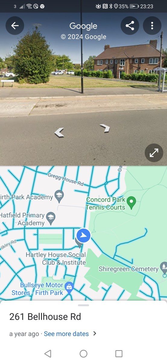
The pic of Smiths grocer reminds me of the shop on the corner of Bellhouse Rd. and Shiregreen Lane…near the gated entrance to Concord Park where, in Summer, ice creams and ice lollies were on sale. Can you remember , Ponytail?
-
In the mid / late 1950s I went to FPGS with Roses son, John , a product of Oakwood private school.whom I think became a solicitor..His family ,by my Council house standards, were “posh”( they had a Yacht moored at Bridlington and took part in sailing regattas) and lived in a detached house at Firvale ….next to St. Cuthberts Church.Their shop was definitely at the bottom of Bellhouse Rd…near to Rotherys fish mongers and the Terminus. Jim Smiths ….a much more down to earth character,shop was on Stubbin Lane. His produce tended to be cheaper than Roses…which was why Mum always did her greengrocery shopping there! Whether or not Smiths took over Roses business later, I couldn’t say…by the time I left school I had other things to contend with than shopping with Mum!
-
I'm sure Rose's was there in the 1950's but the only "Smiths" I remember was on Bellhouse Road going down to Nethershire. If my memory serves correctly there were 2 brothers so one may have had a shop at Firth Park end. Seem to think one was called Jimmy. Their mother lived next door to us on Bellhouse Road in the 1950's/60's. She had the sweetshop next to Hatfield House Lane I & J School and their dad (named Jim?) not a well man, I think was of retiring age and must have worked for the council because he used to tend the flower beds at the school. Don't think he was ever in the shop trade possibly an ex-steelworker.
-
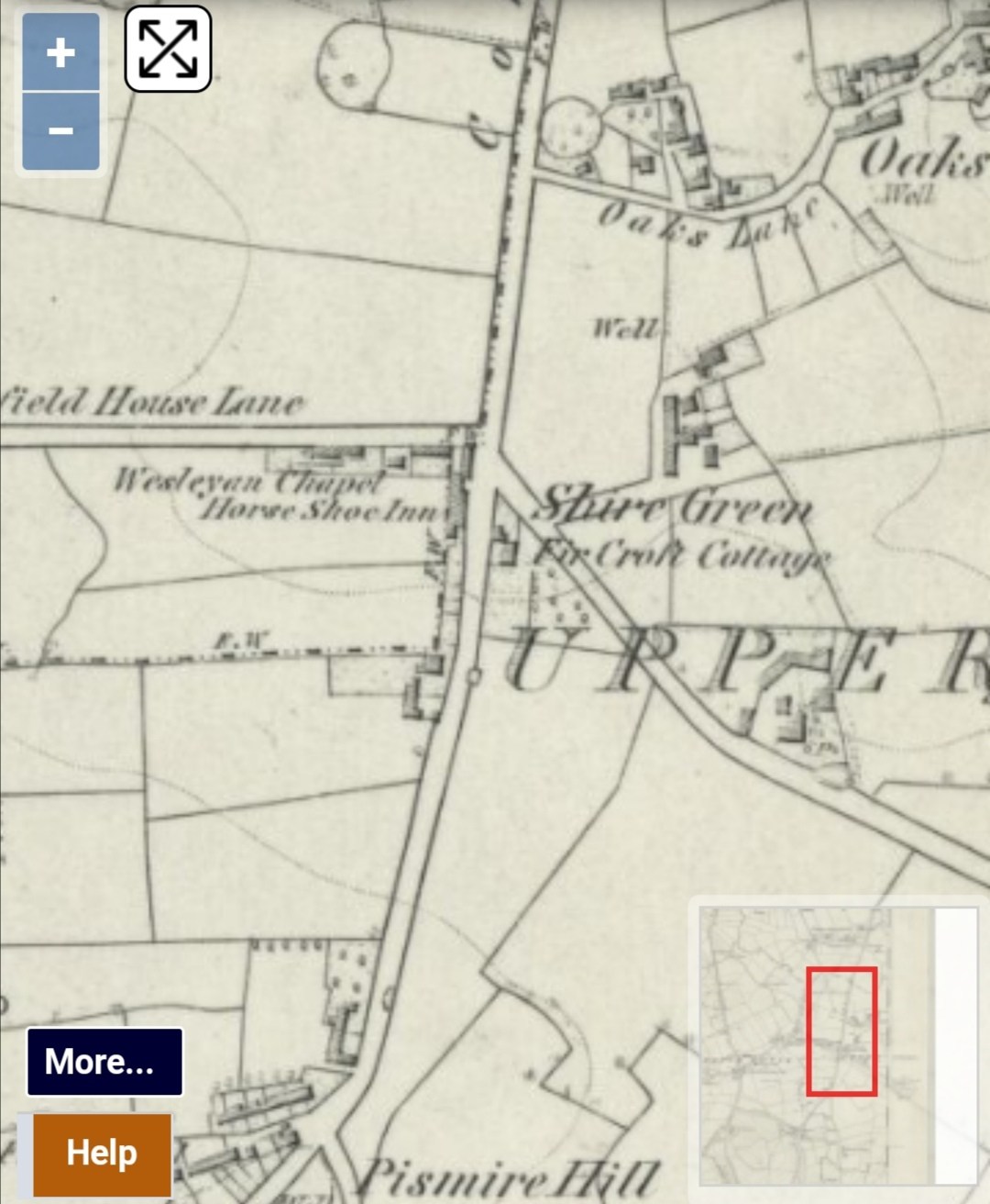
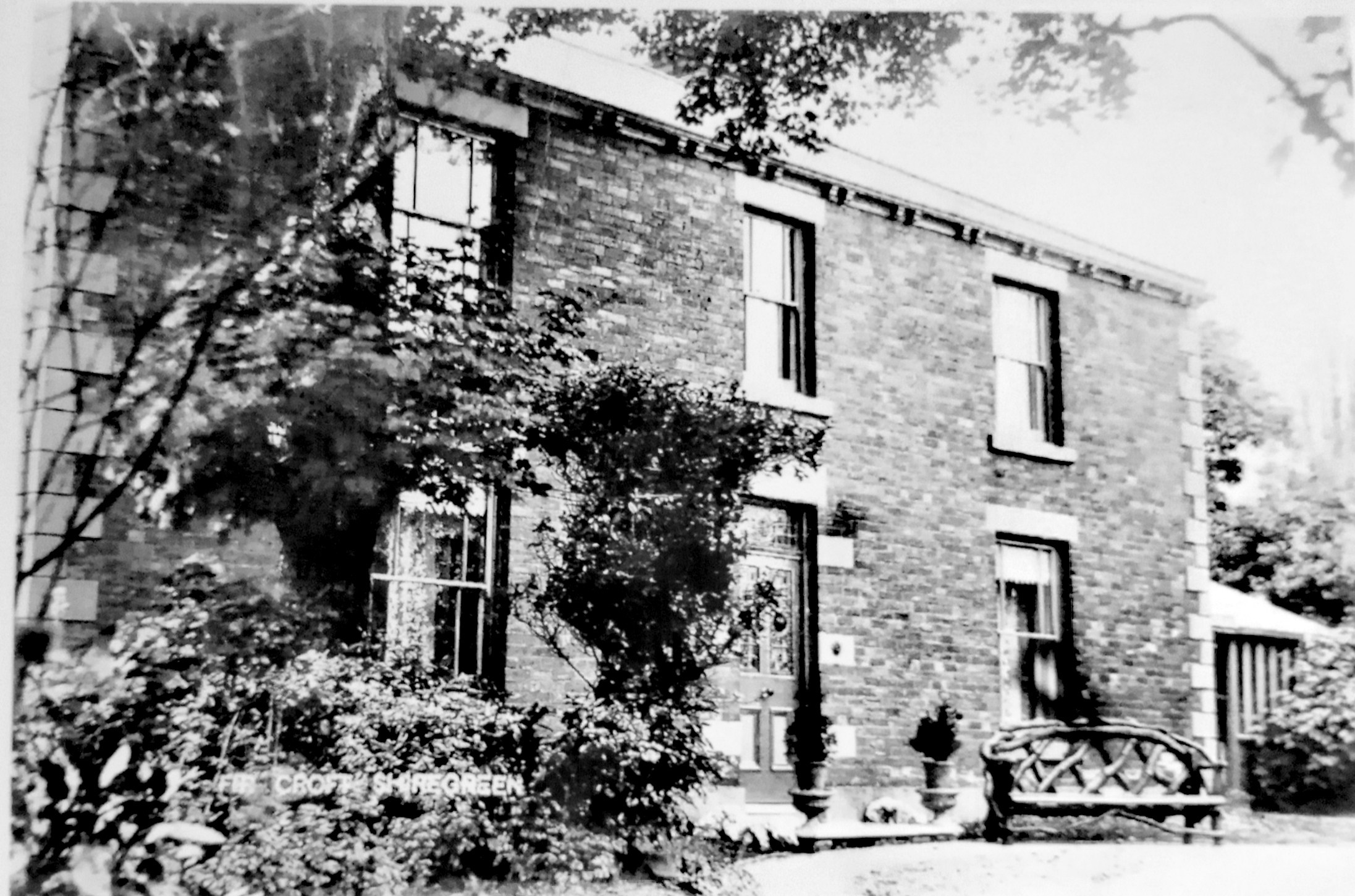
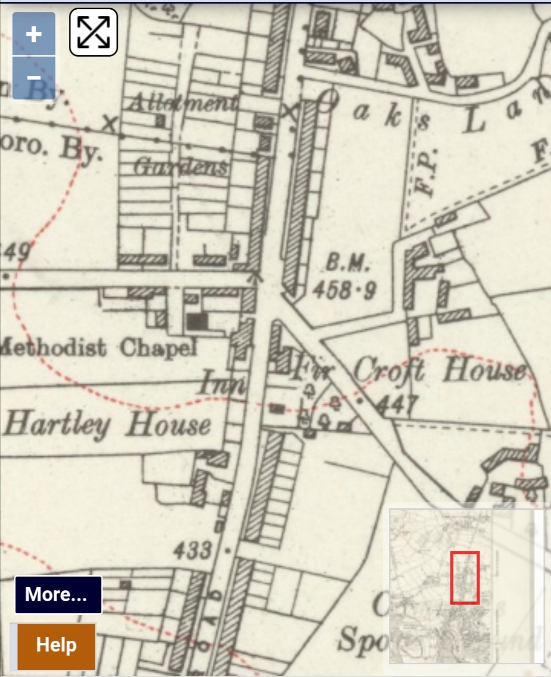
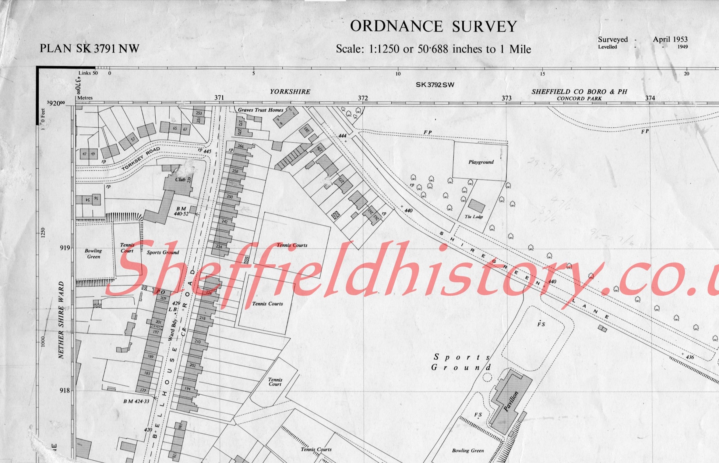
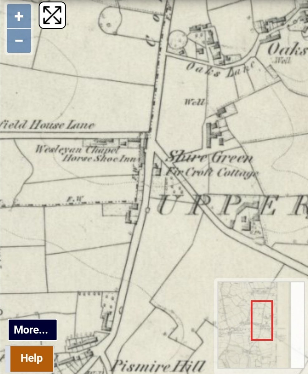
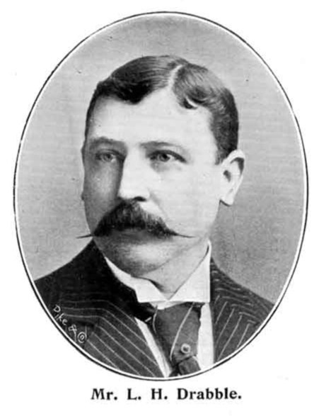
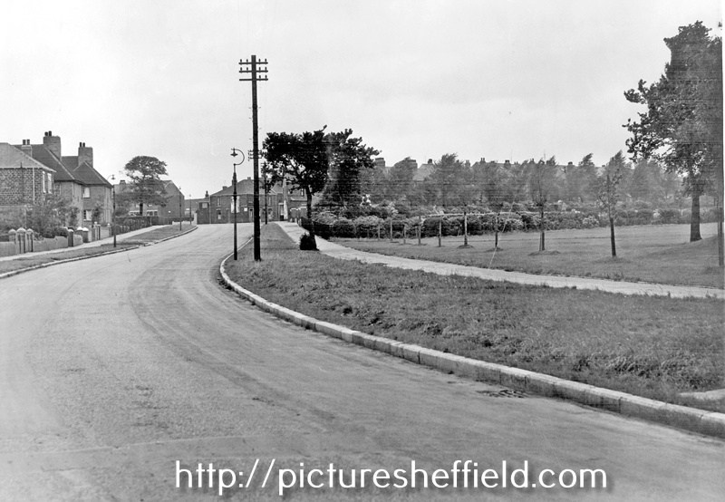
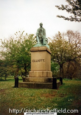
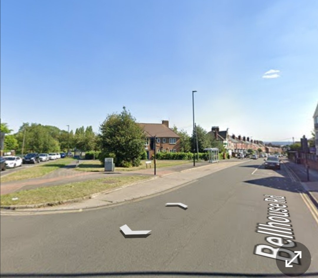
My first thought Fir Croft House was connected to farming, but it appears not; unless anyone knows different. https://www.picturesheffield.com/frontend.php?keywords=Ref_No_increment;EQUALS;v00719&pos=1&action=zoom&id=42527 Bryan Woodriff in his book, "Shire Green, Wincobank and Ecclesfield, writes, "It is said that Ebenezer Elliott, the Corn Law Rhymer, lived here for a while when he left Masboro (Masbrough, Rotherham) He wrote some wonderful verses about Wincobank Hill." A statue of Elliott (1781-1849) was first erected in Market Place, Sheffield but later removed to Weston Park 1875. t03901 Photographer: Michael Beach. Situated at the S.E. corner of Bellhouse Road and Shiregreen Lane, Fir Croft House was not too far from Wincobank Hill. Shown on the OS Map of 1850 marked Fir Croft Cottage but not identified in the 1856 or 1862 Directories. Whites 1879 Directory records Thomas Tweedale, colliery proprietor, Brightside and Grimesthorpe, living at Fir Croft House. By the Directories of 1901, 1905 & 1911, Luther Heaton Drabble (b.1857), dental surgeon is resident at Fir Croft. y08254 1911 identifies Fir Croft, Shiregreen Lane, Shiregreen and Luther Heaton, Drabble has a dental surgery, 69 Wicker, Sheffield. OS Map CCLXXXVIII 1924. Marked Fir Croft House. Bryan Woodriff recounts Drabble was the last owner of Fir Croft House. Later demolished, the Graves Trust Houses were built on the site. Shiregreen Lane looking towards Bellhouse Road, showing clear vista into Concord Park after removal of privet hedges with the Graves Trust Houses visible on the left. 9th September 1954. s19450 A Dentist Surgery was in operation from one of the houses further back down Shiregreen Lane. Although a patient in the 1960's my memory fails me as to the name of the dentist. On the former House site at the junction of Bellhouse Road /Shiregreen Lane there used to be a big tree, fenced off shrubbery and a well used telephone box (at least up until the late 1960's early 70's) with Hoskins chip shop and Slaters grocery shop, (later incorporated the P. O.) Bellhouse Road, below the Trust Houses. Google It's probably my memory playing tricks with me but these aren't the Graves Trust Houses I remember; perhaps they were demolished? I'd like to discover when and who built Fir Croft House and any information connected with the property or the residents, especially the possible Ebenezer Elliott connection. Some years ago I researched Thomas Badger, solictors Bill Books and found his accounts related to various business he carried out over a number of years for Elliott in both Rotherham area and Sheffield but I don't remember coming across a reference to Fir Croft.


-

Clarity Lack, "Lustre Silver" EP Trademark's Owner.
Edmund replied to Kalfred's topic in Made In Sheffield
Frederick Green and Sons were at 84 Bridge street in September 1895, Henry Brooksbank was the manager there, advertising for a youth about 17 years old, used to filing spoons and forks. In June 1896 Greens wanted a girl for polishing and wrapping, and were at the London Works, 7 Eyre Lane - still there in May 1900 when the works were advertised to let . (From 1862 to 1895 7 Eyre Lane had been occupied by Briddon Brothers, silversmiths). -

Clarity Lack, "Lustre Silver" EP Trademark's Owner.
Kalfred replied to Kalfred's topic in Made In Sheffield
Thank you Boginspro and Ponytail for your suggestions and additions regarding Lustre Silver. Thomas H. Blake would be a candidate as he had by 1885 launched his business in Holly Lane as an electro-plate spoon and fork manufacturer, but I do not think the "THB" is Thomas H. Blake. I see "TH" as the "concern" and a "B" for electroplate grade quality. That quote for Frederick Green & Sons, as shown by the respected site "silvercollection.it" could fit but I can not find the Sheffield trade directory entries that back up that sites suggested dating. I checked Sheffield directories around the suggested last decade of the 19th century dates that I could see on line, but found no Frederick Green & Sons. There will be directories that are not on line of course that may have the positive evidence that proves the suggestion. I just think the "Lustre Silver" question needs more answers. Kalfred -
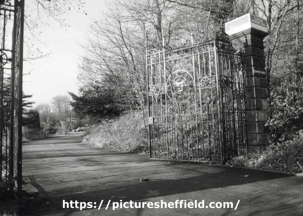
Gates at the entrance to Tapton Masonic Hall, Shore Lane. 19th November 1987. u12334 Interior of Masonic Hall, Tapton Hall, Shore Lane. 4th September 1999. https://www.picturesheffield.com/frontend.php?keywords=Ref_No_increment;EQUALS;u10053&pos=7&action=zoom&id=71205 https://www.picturesheffield.com/frontend.php?keywords=Ref_No_increment;EQUALS;u10054&pos=8&action=zoom&id=71206
-
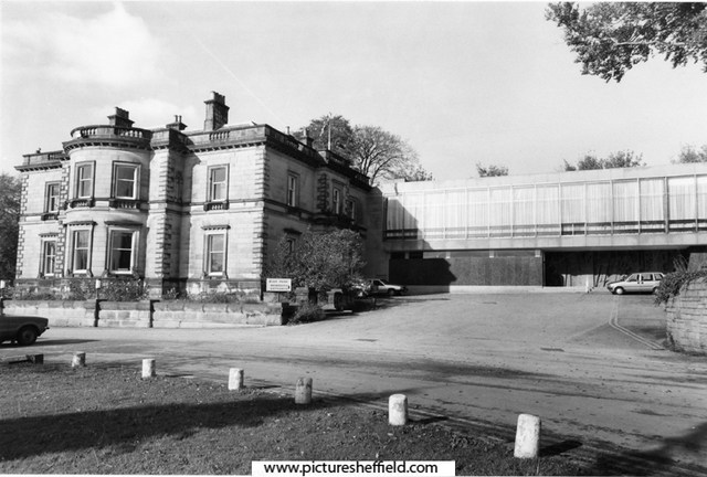
Tapton Hall, Shore Lane showing extension built 1968 by Hadfield, Cawkwell and Davidson. October 1988. s29369 s29367
-
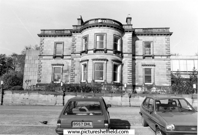
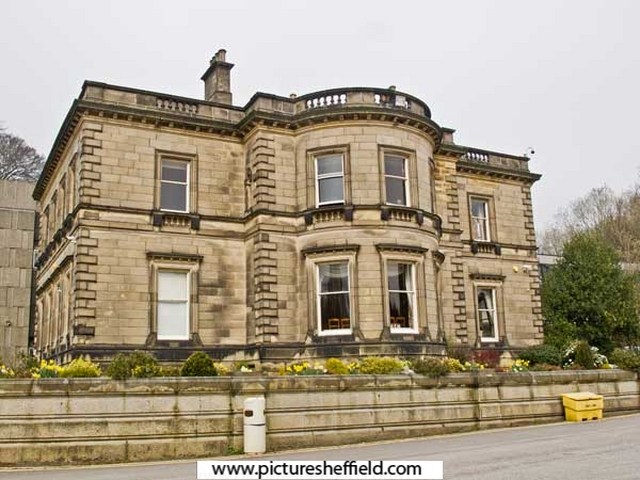
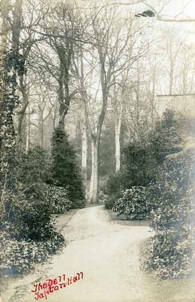
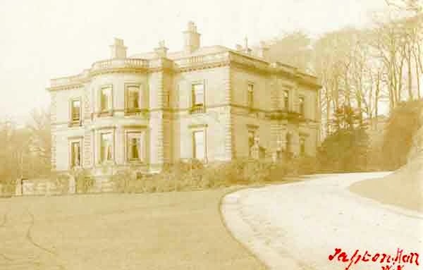
Tapton Hall, Shore Lane., 21st March 2012. c04059 Photographer Alex Ekins. Grade II Listed Tapton Hall, was built in 1855 for Edward Vickers by William Flockton on the site of Tapton Grove, home of the Shore family. Built by Joseph Badger, the Grove was bought by Sheffield banker William Shore in 1790, who enlarged it. William & his wife Mary, nee Evans, were the Grandparents of the famous Florence Nightingale (Mary was the daughter of Anne Evans nee Nightingale). William & Mary's son, William Edward Shore on his coming of age, his Gt. Uncle Peter Nightingale's estate at Lea Hurst, Derbyshire, there after he assumed the 'Nightingale' name & Arms. He married Frances Smith in 1818 and had two daughters, Frances Parthenope b.1819 and Florence b.1820. William Shore died in 1822, and Mary in 1853, after which the Grove was bought by Robert B Mitchell who then sold it on in 1855. Information: S. Hedges. Converted to a Masonic Hall 1966, extension built by Hadfield, Cawkwell and Davidson 1968. p01057 These images were originally part of the Tim Hale Photographic Collection. It was purchased at auction in September 2019 through donations from members of the public and a grant from the Graves Trust. The Dell, Tapton Hall, Shore Lane. p01229
-
Plan of Land near Portobello agreed to be leased by Benjamin Withers to Samuel Sharman and others. 1835. https://www.picturesheffield.com/frontend.php?keywords=Ref_No_increment;EQUALS;arc03848&pos=38&action=zoom&id=99542 Marked: Glossop Road; Withers Street; Withers Lane; Cavendish Street.
-
© GEZ
-
Plan showing West Hill, home of Fairbank. (left side of plan) Broomhall Street. The Burgesses land between West Street and the Moor (Blacklands, Lee Close), [1793], [1816] https://www.picturesheffield.com/frontend.php?keywords=Ref_No_increment;EQUALS;arc04065&pos=113&action=zoom&id=97106 On this have been plotted the streets laid out up to 1816, and measures of the coalpit added. The additions include Earl Fitzwilliam’s and the Duke of Norfolk’s allotments. Shows Glossop Road, West Street, Devonshire Street, West Hill, West Field Terrace, Division Street, Rockingham Street, Blackland Street, Button Lane on Little Sheffield Moor, Carver Street [and Fitzwilliam Street]. [Site of Devonshire Green]. Also James Bowden’s Land, J. T. Younge’s land, James Kirkby’s house, Upper, Middle and Lower Blacklands Close.
-
West Field House not identified on this Plan but comparing it to the previous map posted it's probably the grey shaded property next to West Field Terrace. Broomhall Street. The Burgesses land between West Street and the Moor (Blacklands, Lee Close), [1793], [1816] https://www.picturesheffield.com/frontend.php?keywords=Ref_No_increment;EQUALS;arc04065&pos=30&action=zoom&id=97106 On this have been plotted the streets laid out up to 1816, and measures of the coalpit added. The additions include Earl Fitzwilliam’s and the Duke of Norfolk’s allotments. Shows Glossop Road, West Street, Devonshire Street, West Hill, West Field Terrace, Division Street, Rockingham Street, Blackland Street, Button Lane on Little Sheffield Moor, Carver Street [and Fitzwilliam Street]. [Site of Devonshire Green]. Also James Bowden’s Land, J. T. Younge’s land, James Kirkby’s house, Upper, Middle and Lower Blacklands Close. Royal Hospital - Ground Plans showing how the site was developed. 1930. Plans of 1833 building (Westfield House), 1860, 1880, 1895, 1912 and 1927. https://www.picturesheffield.com/frontend.php?keywords=Ref_No_increment;EQUALS;h00010&pos=26&action=zoom&id=3905
-
It appears the widening of Snig Hill was in the planing for a number of years. Plan of proposed street widening at Bridge Street, Coulson Street and Snig Hill. 1845. https://www.picturesheffield.com/frontend.php?keywords=Ref_No_increment;EQUALS;arc06809&pos=12&action=zoom&id=106240 Marked No. 2. Also shown are West Bar, New Hall Street, Love Lane, Spring Street, Bank Street, Water Lane, Angel Street and Castle Street. From a volume of plans of new streets and street improvements, made by Flockton, Lee and Flockton, 1845. Plan for improving Snig Hill and Coulson Street [Colson Steet], [1830s] https://www.picturesheffield.com/frontend.php?keywords=Ref_No_increment;EQUALS;arc04249&pos=8&action=zoom&id=53522 Marked: Bridge Street, Coulson Street, New Hall Street, Spring Street, West Bar, Snig Hill, Bank Street, Angel Street, Castle Street, Angel Inn, and Bank. Plan for improving Snig Hill and Coulson Street; and Plan for improving Shude Hill and Bakers Hill. 1837. https://www.picturesheffield.com/frontend.php?keywords=Ref_No_increment;EQUALS;arc04248&pos=7&action=zoom&id=48088 Marked: Marked: Bridge Street, Colson Street, New Hall Street, Spring Street, West Bar, Snig Hill, Bank Street, Angel Street, Castle Street, Angel Inn, and Bank. Inset - Pond Street, Shude Hill, Bakers Hill. Houses of John Frith and Joseph Frith at Snig Hill, with adjacent property wanted for street improvement. 1836. https://www.picturesheffield.com/frontend.php?keywords=Ref_No_increment;EQUALS;arc04247&pos=10&action=zoom&id=95321 Marked: West Bar, Snig Hill, Colson Street, Three Travellers, Snig Hill, Black Swan, Bank Street, property of Joseph Firth and John Frith, Bank [Bank Street], Angel Street, Angel Inn, Castle Street and Water Lane.
-
This Sale Plan of Norton House, although not part of the Norton Hall Estate, may be of interest to someone as it fits nicely into the gap of the Map and bordered by Norton Church and Maugheray. Plan of Norton House situate in the parish of Norton and County of Derby. 1868. By Fowler and Son, Sheffield. https://www.picturesheffield.com/frontend.php?keywords=Ref_No_increment;EQUALS;y11283&pos=3&action=zoom&id=104274 Shows [Norton Lane, Cinderhill Lane, School Lane], Norton Church, Chantry monument, Norton House, Maugherhay, The Oakes, Norton Hall estate, and a school.Owners / Tenants: Norton Glebe (Rev Henry H. Pearson, vicar), William Gascoigne, James Jenkin, James Addy, Frances W. Bagshawe, H. Cunliffe, James Rhodes, Charles Cammell and Norton Hall Estate.
-
Norton Estate as Allotted for Sale. 1849 https://www.picturesheffield.com/frontend.php?keywords=Ref_No_increment;EQUALS;y10811&pos=87&action=zoom&id=72807 Includes: A floor plan of Norton Hall (see also y11091); Little London Works; Meersbrook; Cliff Field; Four Lane Ends; Norton Lees; Norton Woodseats; Bolehill; Little Norton; Lightwood; Coal Aston; Land near Coal Aston & the Coal under; Greenhill; National School. Enlarged Plan of Maugheray. Sheffield Local Studies Library: S (25) 6A L.
-
St Hilda's Windmill lane. Dances, guides, brownies, fetes, fancy dress, jumble sales. Shows etc. always something going off and our early life revolved around church. Another church now gone - we got married there and celebrate our 60th anniversary next month. Shiregreen school on Bracken road after school - called a play centre. Dancing, different rooms had different interests be it just reading, craft work, jigsaws, games.
-
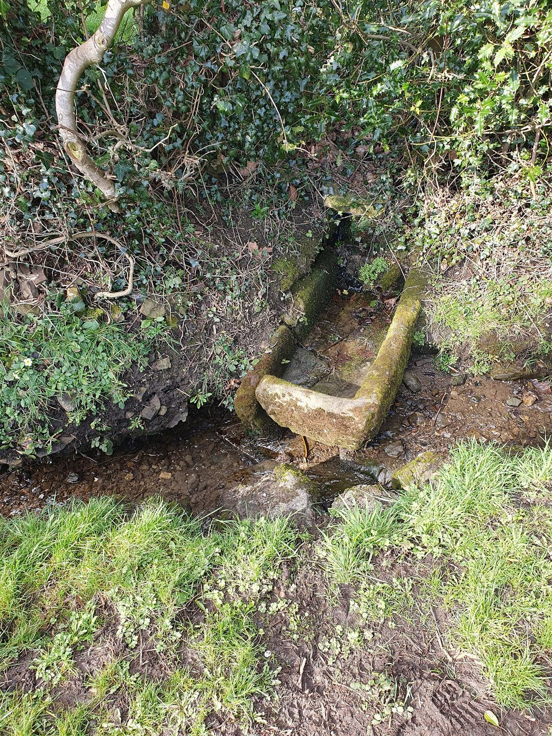
Not sure if this counts? Located in a stream towards the bottom of Carter Hall Lane near Town End, past Charnock Hall school. Photo taken from Facebook..

-
Auction of Public Houses, Shops, Farm, Dwellings & Land of William Staniforth
Ponytail replied to Ponytail's topic in Sheffield History Chat
Link to: Building on Carter Hall Lane. https://www.sheffieldhistory.co.uk/forums/topic/19823-building-on-carter-hall-lane/ -
Auction of Public Houses, Shops, Farm, Dwellings & Land of William Staniforth
Ponytail posted a topic in Sheffield History Chat
Plan of Various Properties formerly belonging to William Staniforth, Esquire, deceased; dated 25th June 1856. https://www.picturesheffield.com/frontend.php?keywords=Ref_No_increment;EQUALS;y10746&pos=6&action=zoom&id=70377 Local Studies Library: Sale Plans 25 June 1856. Particulars of Freehold and Leasehold, Shops, Public Houses, Dwelling Houses, Ground Rents and Vacant Land, Sheffield & Farm at Carter Lane, Eckington, Derbyshire, formerly belonging to William Staniforth, Esquire, deceased; dated 26th June 1856. https://www.picturesheffield.com/frontend.php?keywords=Ref_No_increment;EQUALS;arc01182&pos=10&action=zoom&id=62387 To be Sold at Auction by Schofield & Son at their Auction Mart, East Parade, Wednesday 26th June 1856 at 2pm. Listed: Lot 1. Castle Street junction with Water Lane, shop, house & workshop and outbuildings in the occupation of Edward Bussey, furniture broker. Lot 2. Castle Street, shop, house & premises adjoining Lot 1 in the occupation of Mr. Henry Hills, grocer. Lot 3. Castle Street, shop, house & premises adjacent to Lot 2 in the occupation respectively of Mr. C.H. Hamm, pork butcher & Mr. White. Lot 4. Castle Street, shop, house & premises adjoining Lot 3 in the occupation of Mr. J. Bennett, grocer. Lot 5. Water Lane, all the messuage & Public House, (adjoining the property in Castle Street above described) called the Soldier's Return in the occupation under tenancy of Mr. Matthew Wilson, brewer or his under tenant. Lot 6. Dixon Lane, all the messuage and dram shop at the bottom of Dixon Lane called the Norfolk Arms in the occupation under a tenancy of Mr. William Bradley or his under tenant. Lot 7. Occupation Road, all the messuage and premises called the Gardeners' Arms with garden attached, situated on the east side of Occupation Road in the occupation under a tenancy of William Bradley or his under tenant Mr. Stones. Lot 8. Occupation Road, two closes of land the west side of Occupation Road lying directly opposite the Gardeners' Arms, now in the occupation of George Bates. Very eligible for a Building Club or for Club Gardens. Contains a valuable Bed of Stone which is now being worked by George Bates. Lot 9. Allen Street & Jericho, ground rent of land at the junction of Allen Street & Jericho demised in 1817 to Mr. Joshua Crowder. Lot 10. Allen Street, ground rent of land demised in 1816 to Mr. Benjamin Whittington. Lot 11. Allen Street, ground rent of land on Allen Street demised in 1816 to Messrs Rayson & Taylor. Lot 12. Well Meadow Street, ground rent of land on Well Meadow Street demised 1816 to Joseph Goodlad. Lot 13. Well Meadow Street, ground rent of land on Well Meadow Street demised 1817 to Joseph Morton. Lot 14. Well Meadow Street, a piece of building land at present unoccupied (save for a small workshop in one corner formerly in the occupation of J. Bland now Jubb) having a frontage to Well Meadow Street. Lot 15. Crossland Square, Allen Street, all those 23 messuages, 7 fronting to Allen Street and 16 situated on Crossland Square, now in the several occupations of Charles Fletcher, Frederick Oates, Thomas Chrichley, David Wall, Henry Raynes, Elisabeth Hall, Amos Atkinson and others. Further houses may be built upon it. Lot 16. Allen Street, all those 8 shops and messuages at the junction of Allen Street with Morpeth Street now in the respective occupations of Joseph Middleton, Henry Marples George Lee, John Watson and others. 5 of these fronting Allen Street and the rest are in the yard at the back. Lot 17. Morpeth Street, the range of workshops, yard and sheds situated in Morpeth Street at the back of Meadow Works and recently in the occupation of Messrs Blake and Parkin and now of Mr. Bramhall. Lot 18. Carter Lane, all that Farm called Carter Lodge situated at Carter Lane, Ridgeway in the Parish of Eckington, Derbyshire now in the occupation of Mr. Phillip Sayles comprising the following particulars: Scott Field; Far Field; Far Field ( woody part; Stubbin Cliff Hill; Stubbin Cliff Bottom; Square Close; Wood and Lane; Tongue; Meadow; Upper Croft; Homestead and Garden; Lower Croft; Briery Field; Bamforth Field; Shepherd Field. -
Plan of the Storth Crescent Estate as laid out in building allotments.1862. Marked: Water Lane; Graham Road; Upper Ranmoor Road; Ranmoor; Gladstone Road; Jenkins Lane; Chantrey Road (added Fulwood Road); Nether Green Lane; Nether Green; Brook; Mr. John Hill; Mark Firth Esq; H. Hutchinson Esq; F. Hobson; John Hallam; Mr. W.H. Eadon; https://www.picturesheffield.com/frontend.php?keywords=Ref_No_increment;EQUALS;y10783&pos=12&action=zoom&id=72969 S .F. Holmes, Surveyor, Sheffield. Original at Sheffield Local Studies Library: Sale Plans 1862.
-
The last time I travelled along Nether Shire Lane …..a few years ago…the old farmhouse was still there……the only non Council House on the road. I wonder what is it’s history and is it still standing?
-
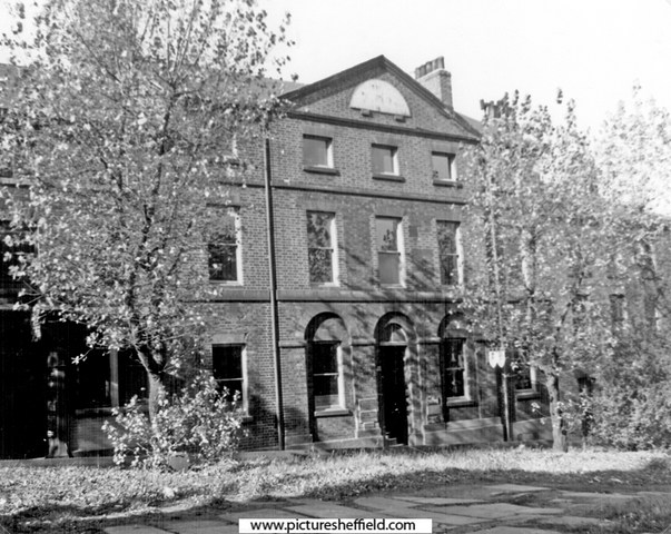
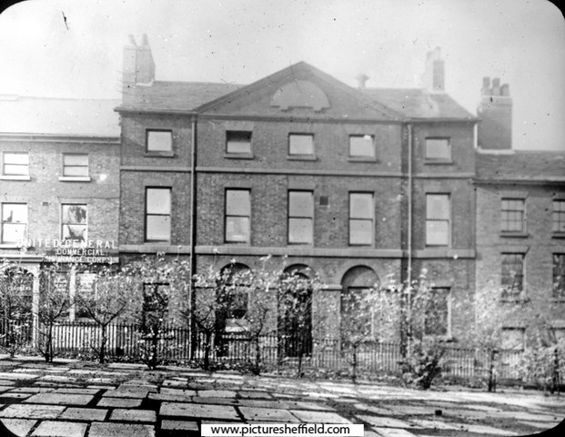
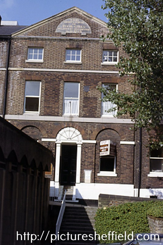
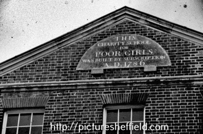
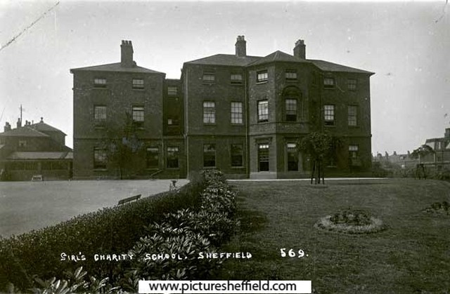
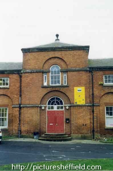
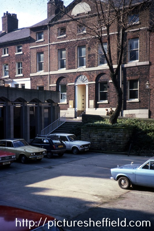
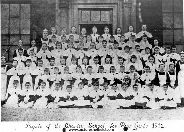
A plan of the Girls' Charity School and premises between it and Campo Lane. 1823. https://www.picturesheffield.com/frontend.php?keywords=Ref_No_increment;EQUALS;arc04072&pos=19&action=zoom&id=80486 Shows Campo Lane, Charity School, [St James Row], glebe land, along with tenants or owners: Samuel Hadfield, Widow Hall, late George Foster, Sarah Foster, Thomas Dixon, - Needham, - Bright, and late Thomas Newton now John Fordham. Land purchased by the Town Trustees. Under lease to the Girls' Charity School, 1840. Shows Campo Lane, Girls Charity School, glebe land and land / property of John Fordham. https://www.picturesheffield.com/frontend.php?keywords=Ref_No_increment;EQUALS;arc04073&pos=18&action=zoom&id=80471 Former Girls' Charity School, No 15, St. James' Row. At the time of this photograph the owner was Mr. Shepherd and was occupied by Messrs. Shepherd, Fowler and Marshall. The school, established in 1786, relocated to Sharrow Lane in 1874. y02117 Photographer: R E Wilson A plain brick, three storey building of no special architectural merit. At the apex of the gable there is a semi-circular-sandstone tablet, of an estimated radius of 3', much weathered, with the inscription; This Charity School for Poor Girls was built by subscription AD 1786. Described in 1950s as in good condition. s06596 April 1977.w01852 Photographer: David Cathels. August 1984w01945 Photographer: Howard Smith Plaque reads: This Charity School for Poor Girls was built by subscription AD 1786. The school was established in 1786 and was removed from St. Jamesand Row to Mount Pleasant, Sharrow Lane in 1874. w00675 Mount Pleasant House, Sharrow Lane (Girl's Charity School)t06680 Entrance to the stable block, Mount Pleasant, Sharrow Lane (formerly Girls' Charity School) January 2000.v04636 Pupils of the Charity School for Poor Girls, Sharrow Lane. 1912.s09127 Children from the Girls' Charity School, Sharrow Lane. s06595 Photographer: T. Firth. Historic Sheffield City Centre Girls’ School becomes Apartment Complex. 13th July 2017. https://www.linkedin.com/pulse/historic-sheffield-city-centre-girls-school-becomes-john-highfield
-
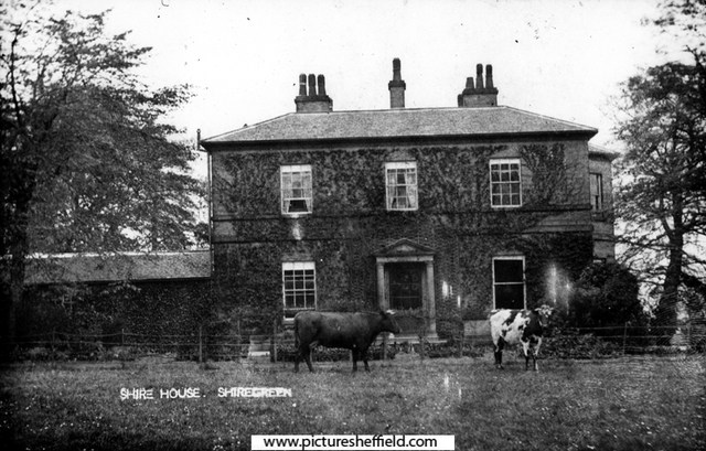
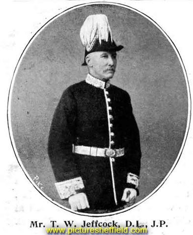
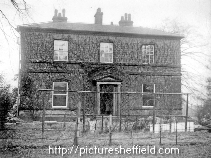
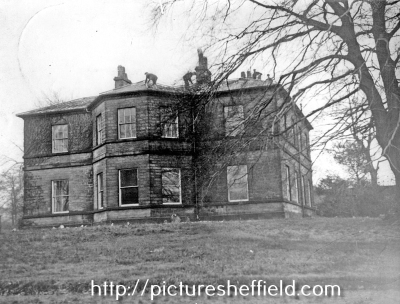
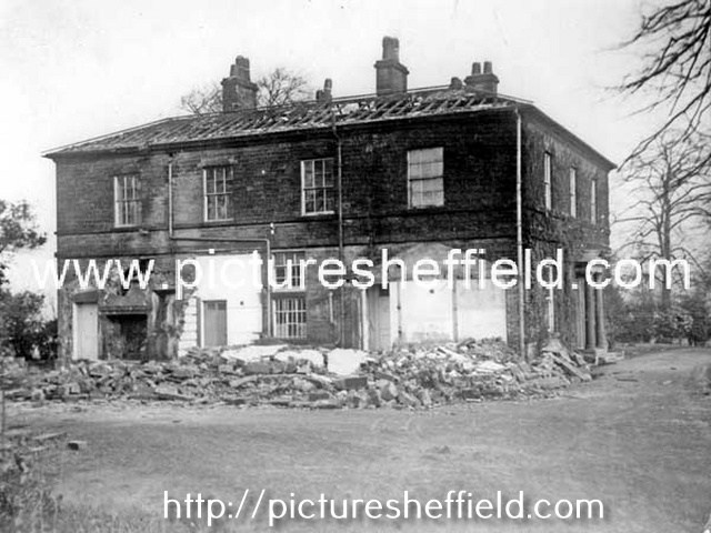
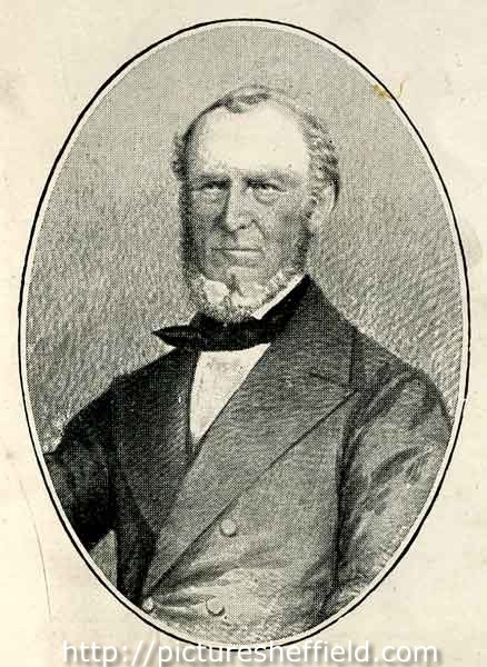
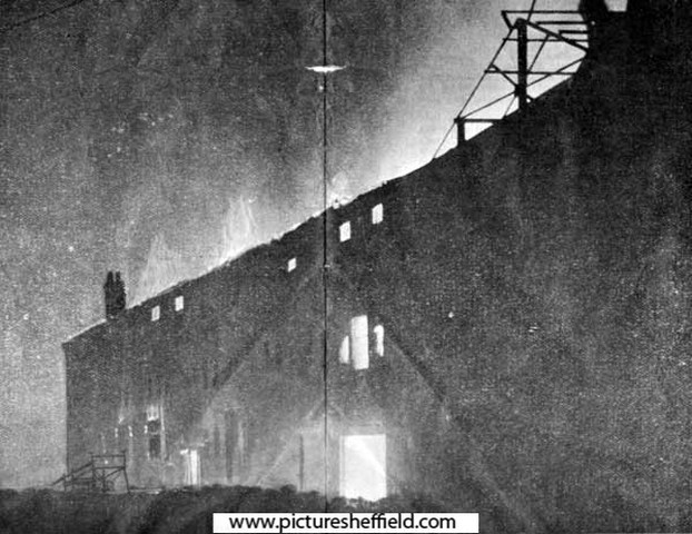
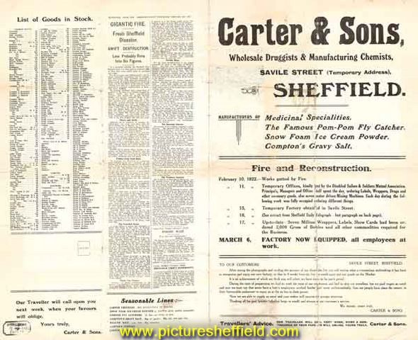
Shire House, Nether Shiregreen. u01160 1910s05982 u01159 Shire House/ Shire Hall, front view. https://www.picturesheffield.com/frontend.php?keywords=Ref_No_increment;EQUALS;v00806&pos=24&action=zoom&id=42608 See also: Sale of superb furniture and choice stock of wine and other valuable effects of Mr. A.A. Hardy dec Wednesday August 5th 1829 Local Studies Sale Catologues Vol 5 Ref: 017.3 S Shire House, (built by Hugh Mellor about 1810, Shiregreen, Wincobank & Ecclesfield, by Brian Wooodriff) isn't mentioned in the 1825 Directory, but there is Andrew Allen Hardy, solicitor and coroner for West Riding of Yorkshire, 19 Bank Street, Sheffield. He had succeeded John Foster of High Green who'd died 4th October 1822 aged 72 years at the Bull & Mouth, Waingate after being taken ill presiding at an inquest. A. A. Hardy held the post until quite suddenly he left the town, leaving large amount of debts unpaid; it was reported he died at Liverpool 20th June 1829, although it was whispered that he was after that date seen alive in America. Thomas Badger, solicitor of Rotherham with offices in High Street Rotherham and Bank Street, Sheffield followed in the role of Coroner, 20th July 1829 after Mr. Hardy's "death." Thomas Badger held the office of Coroner for the next 33 years. Information from the obituary of Thomas Badger, Rotherham Advertiser 2nd August 1862. From White's Directory of 1833 "Shire Green & Nether Shire are neighbouring hamlets 3 miles north of Sheffield and form another seat of the table fork manufacture." In Nether Shire, situated below Nethershire Lane with an entrance off Bellhouse Road, "Shire House a large and pleasant mansion is now the seat of Richard Greaves of Sheaf Works." OS Map 1850. https://maps.nls.uk/view/102345193#zoom=6&lat=4852&lon=14460&layers=BT Richard Greaves died at Shire House, 26th April 1835 aged 55 and buried in the family tomb, Upper Chapel. William Greaves & Sons, Sheaf Works. https://www.hawleysheffieldknives.com/index.php?val=g&kel=1556 Next recorded occupant, 1849 Directory, Capt. Caper, but in 1852 Directory he is recorded as Capt. Capel, staff officer, Shire House. Was he Captain of a Volunteer Brigade, does anybody know anything about him. 1856 Directory the occupant is Henry Hall, Henry, silver plater, Shire House, Shiregreen & Sheffield; Walker & Hall, electro plater & etc. 11 Howard Street. Henry Hall is recorded as a gent, Shire House, 1862 Whites Directory. Henry Hall (c.1802 - 1889), partner of Walker and Hall Ltd. y11266 Image from Walker and Hall, Electro Works Sheffield pamphlet, c.1900 (Sheffield Local Studies Library: 338.4 SST page 11) Walker & Hall Ltd. https://www.hawleysheffieldknives.com/index.php?val=w&kel=367 Change of occupant by the 1879 Directory, Captain Thomas William Jeffcock J.P. (1839-1900) Shire House. Thomas William Jeffcock JP (1839 - 1900), colliery owner, late of Shire House, below Nether Shire Lane, Shiregreen. y08626 For biographical details see 'Sheffield at the Opening of the 20th Century: Contemporary Biographies', S. O. Addy, 1900 (Local Studies 920.04274 SQ 1901 Directory recording "Shire House now unoccupied." Directory 1905, Shire House now in the occupation of James W Dixon. 1911 Directory he had become Major Jas. Willis Dixon. FRGS. Died 1917. James Dixon & Sons Ltd. https://www.hawleysheffieldknives.com/index.php?val=d&kel=372 Link to: Definitely not Victoria most probably. Carter & Sons Glass Bottle. https://www.sheffieldhistory.co.uk/forums/topic/11371-definitely-not-victorian-most-probably/ 1919 see above Sheffield History Link. Geoffrey Cecil Carter, manufacturing chemist (Carter & Sons), Shire House. Former premises of Carter and Sons Ltd., manufacturing chemists, Attercliffe Road. 1987t08420 https://www.picturesheffield.com/frontend.php?keywords=Ref_No_increment;EQUALS;u08477&pos=3&action=zoom&id=90329 Fire at Carter and Sons, wholesale druggist and manufacturing chemists, Attercliffe Road, Sheffield: advertisement for temporary store (at Savile Street) following the fire at the Attercliffe Road store on 10 Feb 1922. y10022 Original at Sheffield Local Studies Library: MP 1705 VL. Carter and Sons, wholesale druggist and manufacturing chemists, Attercliffe Road: on fire at approx. 9.30 pm 19th Feb 1922. y05297 y10023 Demolition of Shire House. u01158 Who was Hugh Mellor, the builder of Shire House? Was there any other occupants? What was the date of demolition.