Search the Community
Showing results for 'coal pit lane'.
-
Clay Wood (or Park) windmill was taken down in 1797/8 at about the same time as the one at Western Bank. The site of the moved Shrewsbury Hospital was close to the old windmill location. George Hill of the Attercliffe windmill assisted the demolition and took some of the recovered machinery back to Attercliffe. But if the above is correct, it was presumably rebuilt very soon afterwards. In 1840 James Crossland, gentleman and corn factor, lived at Talbot Cottage, which was the house with the windmill at the bottom of its garden: Fairbanks 1808 plan: Whites 1838 map: In Sheffield Archives there is an Arundel Castle document (ACM/15/274) titled "Counterpart lease of Pit Hill and Wind Mill closes late Messrs. Booth, Binks and Co." which is a lease dated 30 September 1802 for 21 years to Robert Burnand, broker, the rent being £12 12s, one boon work day. Booth, Binks and Co. were operating the Park Furnace in 1790. Document (ACM/15/262) is dated 4th October 1806 and titled "Counterpart lease of a parcel of land containing 2 roods adjoining Pit Hill field in the Park, with messuage and wind mill, newly erected" which is a lease for 99 years to Robert Burnand of Sheffield, broker, at rent of £4 4s. There was a further lease (ACM/15/315 dated 23 Nov 1814 for 9 years to Thomas Hague of Sheffield Park, builder, the rent was £20 10s one boon work day. By now the area was named as Pit Hill field or Wind Mill Close. The Fairbanks collection has a plan of 1814 (FC/P/SheS/826S) titled "South Street, Park. Wind Mill House in the Park with the ground now proposed to be demised to - Hague by the Duke of Norfolk" which presumably relates to this lease.


-
This also shows "Foresters" (left) don't know whether it something I'm doing/not doing, unable to get the Zoom to work to enable text legible. Possibly reads John Green. Plan of Messrs Brownell's freehold property in and near Carver Street, Sheffield. 1845. https://www.picturesheffield.com/frontend.php?keywords=Ref_No_increment;EQUALS;arc04077&pos=8&action=zoom&id=98738 By J. Fairbank and Son. Endorsed: This plan is drawn from an old survey. Shows Rockingham Street, West Street, Carver Street, Rockingham Lane, and Division Street. Tenants / owners: John Green, Samuel Laycock’s executors, Society of Methodists [Carver Street Wesleyan Chapel], John Moulson, Joseph Moulson, William Moulson, Edwin Moulson, Henry Duke, Francis Carr, Fenton and Shore, Bush and Broomhead and Nadin, Charles Brown, and Sorby and Sons.
-
Hello I'm trying to unlock a family mystery and I hope by researching some addresses, who lived there etc in certain years will help me. Any information that would shed light. I would like advice on which records would give be the best information. I’m assuming it would involve a trip to the local studies library so I would like to have a plan before I make the journey to Sheffield. The addresses and years are; 1876 12 ct 17h Bernard St 1887 Castle Court 7 Sylvester Lane 1887 8 Castle Yard, could be 251 or 285 1891 32 ct 3h Fitzwilliam St 1909 1 Regent Lane 1913 25 ct 3h Thomas Street Also was there a different numbering system also use such as for example 13 house 2 court also referred to as 250. Many thanks!
-

SHEFFIELD | Bramall Lane and Shoreham Street in downtown Sheffield
Sheffield History posted a topic in Sheffield Videos
Another fantastic Sheffield Video! Watch video here 👉 SHEFFIELD | Bramall Lane and Shoreham Street in downtown Sheffield -
SHEFFIELD DRIVE | Arundel Gate to Bramall Lane | Sheffield Tour filmed in 4K
Sheffield History posted a topic in Sheffield Videos
Another fantastic Sheffield Video! Watch video here 👉 SHEFFIELD DRIVE | Arundel Gate to Bramall Lane | Sheffield Tour filmed in 4K -
Another fantastic Sheffield Video! Watch video here 👉 I walked through Jew Lane in Sheffield!
-
SHEFFIELD TOUR | Campo Lane and Paradise Square | Sheffield walking tour
Sheffield History posted a topic in Sheffield Videos
Another fantastic Sheffield Video! Watch video here 👉 SHEFFIELD TOUR | Campo Lane and Paradise Square | Sheffield walking tour -
SHEFFIELD TOUR | Black Swan Walk : The SECRET hidden lane on Fargate you didn't know about!!
Sheffield History posted a topic in Sheffield Videos
Another fantastic Sheffield Video! Watch video here 👉 SHEFFIELD TOUR | Black Swan Walk : The SECRET hidden lane on Fargate you didn't know about!! -
I have traced an ancestor living at 2 Green Square, Charles Lane on the 1851 census. The nearest I can get following the route of the census is somewhere between Eyre Lane and Arundel Street. I've used the OS 25ins 1892-1914 map & the 1906 Insurance maps but the location is not identified and I'm assuming it was developed before these dates. Does anyone have any ideas?

-
Unlike Stand House Farm which was on the other end of the long lane, Windy House didn't survive the construction of the Manor Estate. The farm was probably built around 1660 to 1700. Along with the lane which went to Stand House and from there circled back to Manor Lane and the Manor Lodge. Initially the lane would have connected to the Duke of Norfolk's Private path probably just before the 1779 turnpike road (now City Road). But when that fell out of use it would have been joined up to the Turnpike. Windy House would have been an add on to the lane, which was really a lane to the hunting "stand" where Stand House was built, from the private path.
-
I have traced my Great Grandfather living at 5 Brightside Lane in 1871. i have an early map which does not show house numbers but on the assumption that road number start nearest the city centre i have estimated number 5 as being at the intersection with Newhall road to the left of the pub on the corner (see attached map). Does anyone have a map showing house numbers or any photographs of housing on Brightside Lane around this time?

-

Catholic Church of St Charles, Attercliffe
Ponytail replied to dunsbyowl1867's topic in Sheffield History Chat
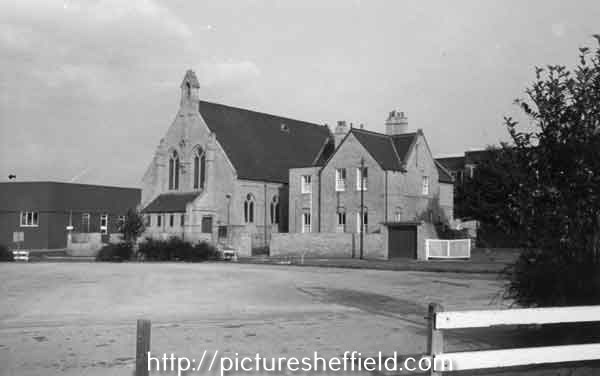
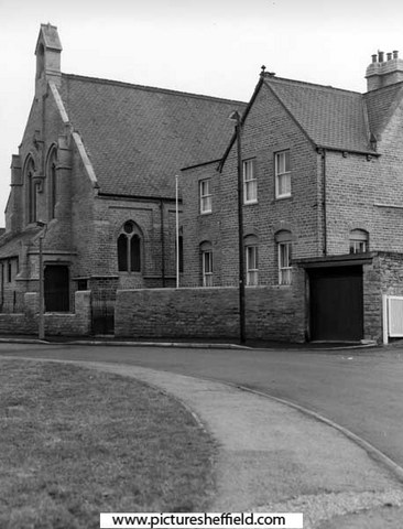
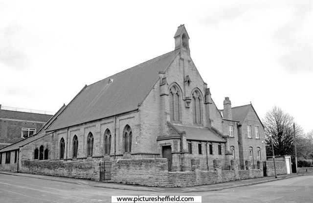
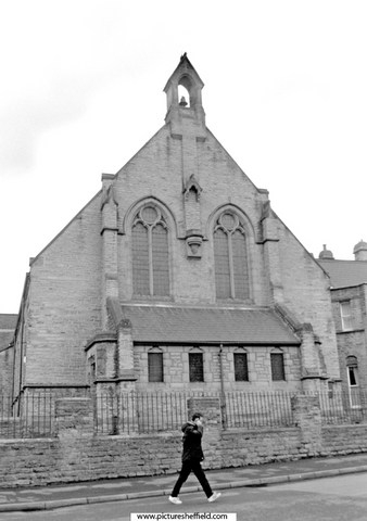
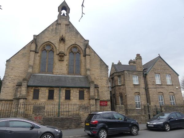
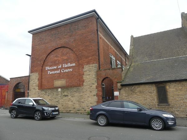
St. Charles Borromeo, Roman Catholic Church, St. Charles Street. Who was Charles Borromeo? https://en.m.wikipedia.org/wiki/Charles_Borromeo Taking Stock: https://taking-stock.org.uk/building/sheffield-st-charles-borromeo/#:~:text=It was dedicated to St,Serpentine in London in 1867. Sketch of St. Charles Borromeo Churchs05094 Plan of St. Charles' Borromeo Roman Catholic Church and School, St. Charles' Street, Attercliffe. 1876. https://www.picturesheffield.com/frontend.php?keywords=Ref_No_increment;EQUALS;arc04439&pos=94&action=zoom&id=151810 Church and Presbytery, St.Charles Street. 1987.t08439 u08403 28th January 2005.c00816 Photographer, David Bockingc00817 2021a07116 Photographer, Andrew Milroy Pastoral Centre, Roman Catholic Diocese of Hallam, St. Charles Street. 2021. a07115 PhotographerAndrew Milroy Plaque on Diocese of Hallam Pastoral Centre, Heppenstall Lane. 2006. https://www.picturesheffield.com/frontend.php?keywords=Ref_No_increment;EQUALS;t10471&pos=9&action=zoom&id=91432 St. Charles School, built 1871, rebuilt 1929 in memory of the Very Revd. Joseph Hurst V.F., founder and first rector, 1866-1905. St Charles Borromeo Roman Catholic Church, Sheffield, Parish Records. https://discovery.nationalarchives.gov.uk/details/r/76a87f80-ae50-499b-8153-d3d3cf131a64 Local Heritage List. https://local-heritage-list.org.uk/south-yorkshire/asset/7598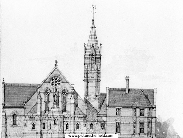
-
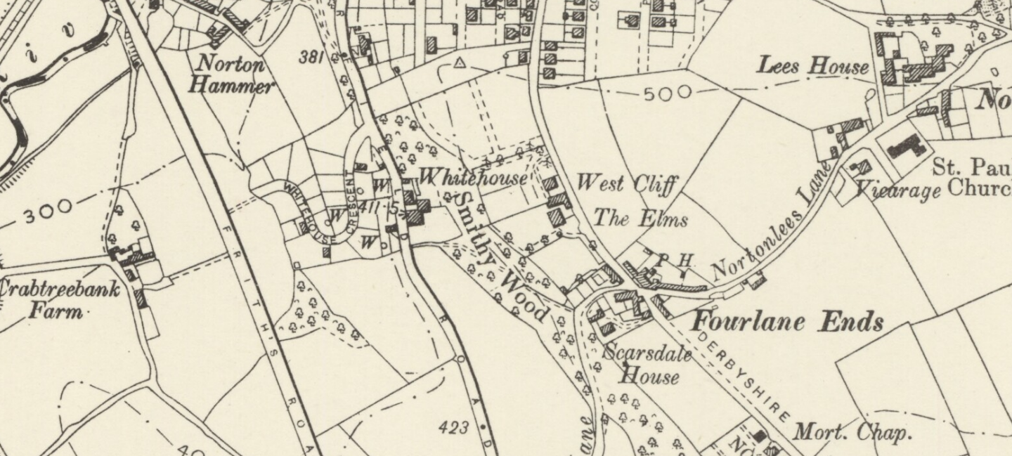
Would love to know more about the houses which stood off Derbyshire lane (on the one-way section below the Scarsdale Road junction). On the 1897 map they are referred to as West Cliff and The Elms. Various gateposts and parts of old wall are still visible from the road. Presumably they were demolished in connection with the quarry/brickworks off Chesterfield Road (now Homebase etc).

-
Link restored: Old Barrack's Infirmary, Barrack Lane / Thirza Street. The old Barracks were on Penistone Road which was formerly called Low Road. s07451 Nos. 225 and 227, Penistone Road at the junction with Barrack Lane formerly the Old Barrack's Infirmary but being used as Flats. 18th February 1964. https://www.picturesheffield.com/frontend.php?keywords=Ref_No_increment;EQUALS;s18668&pos=1&action=zoom&id=21329
-
Flood Claim Link Restored: Henry Greenwood. Beerhouse Keeper, "Paddy's Goose", Love Lane, Sheffield https://sheffieldfloodclaimsarchive.shu.ac.uk/claimSummary.cfm?claim=7-5885
-
For anybody interested in the Sheffield steel industry I was always told that the steel industry started there because of a ready supply of charcoal, iron ore, millstone grit and water power. In the 17 and 1800's it was the water power of all the Sheffield rivers that provided the energy to make it all happen. Back then most of the rivers around Sheffield were dammed and the water used to turn water wheels. An 1855 ordnance survey map of that time shows dams, weirs and water wheels throughout the area. As far as I know, only the Abbeydale Industrial Hamlet, is the only one left and is a museum. I'm not sure if it actually works or is a static museum. However, my Dad worked at the water wheel driven forge at Clay Wheels Lane, almost opposite where Fletcher's bakery is - remember the Fletcher's fire? He worked there through the 1930's till it closed sometime in the 1950's but the actual forge was built around 1755. At some time after it was built it was used to forge large guns for the navy and was owned by Thomas Firth and John Brown Ltd. Some time later the forge became the property of the Tyzack family who already had the tenancy of the Abbeydale works – see http://www.tilthammer.com/bio/tyzac.html When Tyzack’s took the interest in Clay Wheel forge they used it to produce scythes for the agricultural industry – similar to what they were doing at Abbeydale. Apparently many of the male members of my family were master scythe forge men. Sometime in 1941 a film crew from Thomas Firth and John Brown Ltd. Came to film the Clay Wheel forge for posterity and I was lucky enough to obtain a 16 mm copy of it. I (rather crudely) made a VHS copy some 25 years ago by projecting it onto the dining room wall and shot it with a VHS camcorder. I have now posted it on You Tube at http://www.youtube.com/watch?v=AqV3jtkQSe4 The film is interesting because it shows what Abbeydale Works might have been like when operating – although I believe Abbeydale was smaller than the Clay Wheel forge. I apologize for the poor quality of the video – I do still have the 16mm. movie and if there is any interest I will have it professionally converted and re-post. Also for anyone interested I have many high quality black and white photographs of the clay wheel forge from various sources. Edit: dead link
-
Does anyone recall the Toft Wood Allotment Society? My Grandfather had an allotment at the bottom of the Bole Hills at Walkley which backed onto Tinker Lane. I remember playing in the greenhouse and was fascinated by the water butt - amazing what amuses a child!! In the sixties Sheffield Corporation decided to build some flats on the allotment area so Granddads allotment was no more - a great sadness to him as he'd just retired. I do remember a large green hut down Two Troughs, which was the extension of Bole Hill Road past Bentley Road towards Clough Fields. The hut was the headquarters of the Toft Wood Society and they held a Chrysanthemum Show there every year. The remains of it can still be seen if you look carefully but is mostly collapsed. I can still remember that smell of Chrysanthemums and the hushed tones of peoples voices. I know we had to be very careful not to knock anything over!! Have I imagined the name of this Society, did it have another name?
-
Coal fires were good for toasting your bread with a toasting fork, then you could get in front of it for a warm as well, but careful the bread didn't drop off the fork. Toast never tasted the same when we "went electric" and had to put it under the gas cookers grill. Sorry I digress. A downside of coal fires if you hadn't swept your chimney regularly, risked a fall of soot putting out the fire and making a real mess in the room with soot and smoke. Do these modern day wood/coal burning stoves need their flues/chimneys sweeping? It won't be as much fun to watch.
-
You might enjoy this from my family history - Chimney sweeps are a rare sight nowadays with the advent of gas fires and central heating. During my childhood they were frequently to be seen riding about on their bikes with their brushes strapped to their backs and their faces black with soot. It would create a bit of amusement for the children around who stood around watching and waiting for the brushes to appear out of the chimney tops. Dad as usual, loathe to waste money on something he felt he could do just as well as anyone else, bought his own set of brushes. No matter how careful he was soot still got everywhere. All the furniture would be moved back and covered with old sheets and the carpet rolled back. A sheet would be draped over the fireplace under which he would disappear along with the brushes and extending rods. Invariably he would get the brushes stuck up the chimney and amid much swearing, cursing and large amounts of falling soot, Mum would inevitably get the blame for it all. We would keep being sent outside to see if the brush had appeared yet. When the rods and the brush were finally pulled down there would always be a large fall of soot and dad would emerge coughing, spluttering and cursing with a black face. People of my generation often say there is nothing to beat a coal fire. Perhaps there isn't when you do see a good one burning but what about trying to light one on a cold winter's morning. No thank you. First there was the grate to empty and the ash-pan. Crumpled up newspaper would be placed in the grate with firewood placed sparingly across it and if mum could afford it firelighters. Decent sized pieces of coal would then be placed on and the newspaper lit. The shovel would be propped up across the front and a sheet of newspaper placed across it to help 'draw the fire'. More often than not the sheet of newspaper would catch fire too. Some housewives would throw sugar or lighter fluid on to help get it going and many a chimney fire would be started that way. Coal fires were only warm if you were sat on top of them: the back of you would be freezing.
-
Brunswick Steel Works, Denby Street & Albion Steel Works, Arley Street
Richard Vessey replied to Richard Vessey's topic in Sheffield History Chat
Very interesting to see the adverts and directory entries (which I have copied). Wardrobe & Smith had premises next to Matthias Spencer & Sons in Arley Street. It seems that when Vesseys bought Matthias Spencer & Sons in the 1920s they must have also bought out Wardrobe & Smith as the Vessey company occupied the whole site. Members of the Wardrobe family remained on the board of John Vessey & Sons (holdings) Ltd. Matthias Spencer & Sons were file makers and steel makers but upon purchase by Vesseys, the file making side was sold to Spencer Clark (previously Walter Spencer & Co.) which had family connections to Matthias Spencer. It seems that Matthias Spencer must have also made picks for coal mining as this direction of business was continued by Vesseys, upgrading to many tools for the coal extraction business including the "Clever Mary" which I think was a pick head which when added to many others on a chain could rip through a coal seam. I attach a collage of photos of crucible pouring from 1948 which I assume must be the Brunswick Steel Works in Denby Street (and not the Matthias Spencer works). It would be very interesting if anyone has any knowledge of when crucible steel making stopped at Brunswick Steel Works (Vesseys), Albion Steel Works (Matthias Spencer) and Wardrobe & Smith. Also fun to note that Denby Street was called New Thomas Street and Arley Street was called Cross George Street. Replying to Lysanderix, it would be interesting to hear more on dealings with Vesseys in the 60s as I believe their steelmaking stopped in the late 50s and the majority of the Brunswick premises was then sold to Harrisons, just keeping offices until they were transferred to the Matthias Spencer site in Arley Street, then selling the old offices also to Harrisons in the early 60s. There was investment in electric steel furnaces before the end. It would be great to gather when steel making finally stopped at both Brunswick and Albion steel works. In the end, the Vessey name dropped and the enterprise continued as Matthias Spencer & Co (under Vessey ownership) specialising in coal mining equipment into the 1980s when the business moved to a "green field site" as Spencer Todwick - not quite sure what happened ultimately to Spencer Todwick but as coal mining pretty well evaporated in the 1980s with the new government then, I assume that the company must have gone out of business. All and any feedback appreciated..... thank you.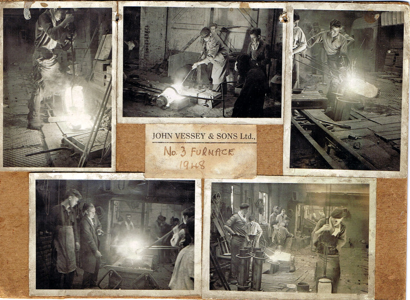
-
In 1723 John Justis leased from the Norfolk Estate "For building a cutlers grinding wheel in the nearest convenient place from Upper Horse Pitt. Close to the head of Moreton Dam...of one end and as many troughs as convenient, nothing to prejudice Slack Wheels above Moreton Wheel." 1724 took a lease of the completed wheel. In 1726 he mortgaged the leases of Sandbed and Owlerton Wheel to Joseph Broadbent. 1740, Broadbent built a new weir and 1742 enlarged the premises. Broadbent died in 1761 and Sarah and Thomas Broadbent are recorded as leasing the wheel. 1783 Thomas Broadbent, bankrupt. Plan of Sandbed Wheel held of the Earl of Surrey by the assignees of Thomas Broadbent. 1783. https://www.picturesheffield.com/frontend.php?keywords=Ref_No_increment;EQUALS;arc02739&pos=3&action=zoom&id=92280 Wheels, dam and goit clearly shown and named; numerical list with descriptions and acreages; height of fall given. Neepsend village, and lands belonging to the Earl of Surrey between Pye Bank Closes and Far Field, 1784. https://www.picturesheffield.com/frontend.php?keywords=Ref_No_increment;EQUALS;arc03991&pos=4&action=zoom&id=102795 Cath. Burton, late John Senior, No. 1 Pingle. Anne Hirst, 2 Horse Pits, 4 Upper Car Meadow, 5 Nether Carr Meadow, 6 Near Long Dole, 7 Farther Long Dole. Assignees of T. Broadbent, 3 Sandbed Wheel with the dam, tail goight, and vacant ground betwixt them and the river. William Stocks, 8 Ox Dole Close. Widow Vickers, 9 Stubbing, 10 Dole, 11 Marsh, 17 Smithy Croft (including the garden), 18 Acre Field, 19 Hilly Field. Joseph Clay, 20 Farthest Low Close, 21 Farthest Upper Close, 22 Middle Upper Close, 23 Upper Garden, 24 Nearest Upper Close, 25 Nearest Low Close, 26 Middle Low Close, 27 Lower Garden. Silvester Wadsworth, 12 Far Close, 13 Middle close, 14 Nearest Close, 15 several houses, etc. James Creswick, 28 a garden, 29 - 30. James Kay, 32 common. John Ward, 33 Commons south of the footway, 34 commons north of the footway. John Milner, 35 Commons, 35a garden (south of the footway). Thomas Burgan, 37 Commons, 38 commons, 39 commons (south of the footway). Jonn. Moore, 40, 41, 42 Pye Bank Close. Samuel Barlow, 16 a garden (inclosed from the waste grounds). Kinsey Winnell, 31 a small croft, smithy, etc. Shows Farfield, Neepsend, Pye Bank [closes], River Dunn [Don], 'Wood called Mire Acre Wood', [Cooks] Wood, Harvest Lane End, wear [weir]. The lease passed to merchant, Robert Trickett who assigned the lease in 1791 to a group of cutlers, one of whom was Peter Cadman (1794 list) By this time the Wheel had 52 troughs in three wheels and also a tilt. 1808 the tenants purchased the freehold from the Norfolk Estate. Advertised for sale 1816 & 1818 but the Cadman Association remained until 1852, selling to William Makin. Makin died 8th January 1856 and the Trustees kept the wheel as shown from their Flood Claim for £1418/11/7d. William Makin, gentleman of Attercliffe Listing: Damage to Clifton Works, Hillfoot near Sheffield, comprising: Grinding Wheel;Tilts; File Manufacture; Cottages; Stable; Dam; Shuttles; Weir; Goights; Culverts etc. in the occupation of Messrs William Makin & Sons lessees. https://sheffieldfloodclaimsarchive.shu.ac.uk/claimSummary.cfm?claim=6-5475 Claimed also: James Marchinton and Benjamin Makin carrying on business under the firm of William Makin and Sons, steel and file Manufacturers of: Clifton Works, Hillfoot and Attercliffe near Sheffield. https://sheffieldfloodclaimsarchive.shu.ac.uk/claimSummary.cfm?claim=11-5474 Thomas Yates, file cutter residing No.12 Court, new Edward Street. Employed at William Makin & Sons, Hill Foot had his claim dismissed. https://sheffieldfloodclaimsarchive.shu.ac.uk/claimSummary.cfm?claim=1-419 Selling, 1886 to John and Henry Andrews who eventually became Andrews Toledo. The claim revealed a steam engine boiler was in use although steam and water power was still used 1897 and even in 1907 listed as, still using Water Power. For added information see: Water Power on the Sheffield Rivers, edited by David Crossley with Jean Cass, Neville Flavell & Colin Turner.
-
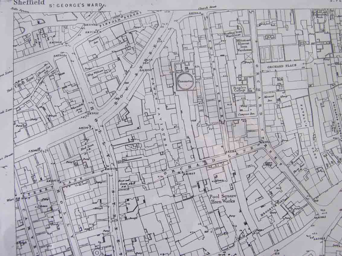
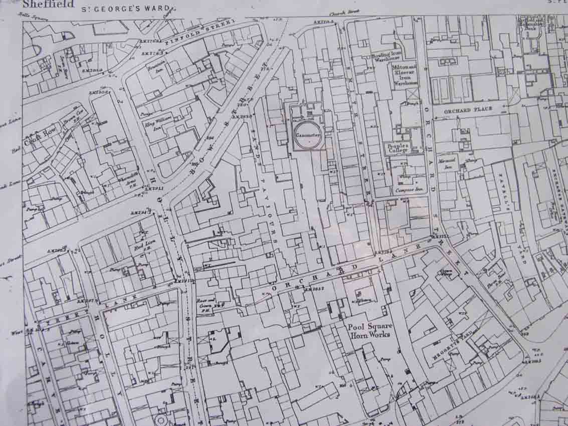
In 1874 a plan was produced by the Sheffield architects, Innocent and Brown, for the laying out of Leopold Street and the realignment of Church Street and Bow Street (now West Street). In 1876 the area between Orchard Lane, West Street, Orchard Street and Balm Green was covered by a huddle of old houses in two streets now gone (Smith Street and Sands Paviours). This site was bought by the Sheffield School Board (SSB) for building the Central Schools and offices for themselves. At this time, Mark Firth (of steel fame) was interested in founding an Adult Education College which he intended should become a University College, so the Board sold him part of the site at the corner of West Street. The new building, called the Firth College after it's benefactor, was opened by Prince Leopold (hence Leopold Street) in 1879. Sands Paviours Sands Paviours Map 1855

-
can anyone tell me exactly where it was as it no longer exists as far as i know
-
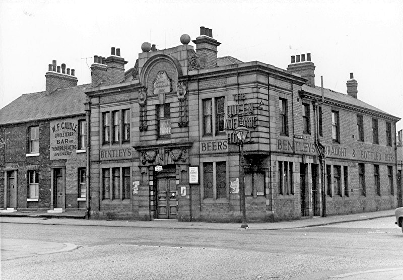
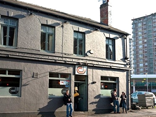
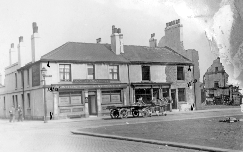
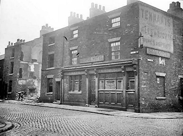
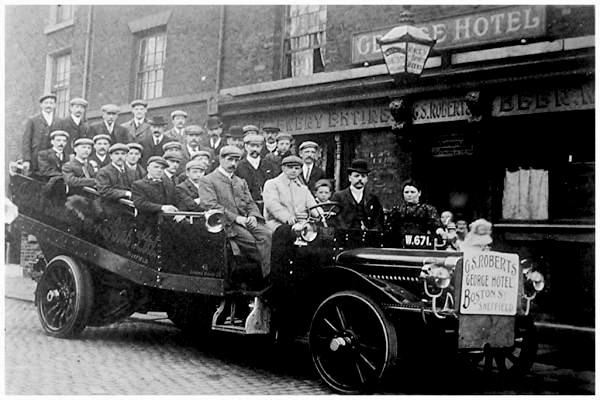
“Dus` Tha` Fancy A Pint Lad” Welcome back to our on-going roam around Sheffield’s old pubs, most have gone but some are hanging on to life. Our area today is what is or was affection ally known as Little Sheffield, I know Mr D & Mr S are scratching their heads and saying “Where’s That Then?” Little Sheffield, a village and close to the main town of Sheffield was redeveloped to cope with the rapidly increasing growth in population. Separated from Sheffield town by the uninhabited, barren, gorse-covered, Sheffield Moor, Industry here was based on water-power provided by Porter Brook with water-wheels at Sharrow Mill (Sharrow Vale Road), Sharrow Forge (Napier Street), and Bennett’s’ Wheel (Vulcan Works). The latter two mill-dams and Broomhall Corn-mill dam off Ecclesall Road were drained and filled-in around 1870 providing land for houses, schools, and new industries. I believe that Little Sheffield ran from around Pomona Street just off Ecclesall Road, over to Cemetery Road up to Sharrow Lane, back to St Mary’s Church on Bramall Lane, then up to Abbeydale Road to near Sharrow Lane again and strangely enough the area below Havelock Square and as far as Eyre Street were also counted as Little Sheffield, it’s the small area within these parameters that our pub tour lies. I must mention that within a very small area there were four breweries, Wards had the Sheaf Brewery on Ecclesall Road, which stood where the Wetherspoons Granary pub now stands, (why that name?) now stands, just a few hundred yards away roughly where Waitrose now stands, here stood the Old Albion Brewery, just behind the Old Albion on Napier Street stood the Dantzig Brewery, just on the corner of Bramall Lane and John Street, where the new Spar shop now stands, here stood the Britannia Brewery and finally just on Cherry Street stood the Hope & Anchor Brewery, in its place stands anchor Point, at the gates was the Hope & Anchor Logo sadly it was removed but they did retain the old colour of the boundary wall of the brewery, to say that the demon drink was made here, its name is misleading as it has religious meaning, it came from the Letter to the Hebrews (6:19): "We have this as a sure and steadfast anchor of the soul, a hope." Our year is 1893 but some of the pubs we set foot in were open long before then, we start off by strapping on our electric time trousers and head for the Norfolk Hotel at No1 St Mary’s Road, which stood just on the corner with Bramall Lane, this was a Gilmour’s house and it was open in 1881 and its first licencee was Joseph Chappellow but at the time of our visit in 1893, his widow, Mary now holds the licence, this corner pub stood just past St Mary’s church, more or less opposite where Hermitage Street met the Lane and it was just a Beer house then seems the name came later its hard to pinpoint exactly where it stood because of MASSIVE road changes and demolition of our old buildings, we leave the Norfolk cross over Bramall Lane to the Queen Adelaide at 32 Bramall Lane even though it stood on the corner with Hermitage Street, this brilliant pub was up and selling beer in 1825, George Beavis was the first landlord, it sold Bentleys Beer, this Brewery was at 29 Castle Folds but was taken over by Stones later, on our visit John Willey Dungworth was the landlord, this pub had a reputation for the entertainment it provided by its customers for the customers, a truly well missed pub, we leave this friendly pub with the sound of After The Ball Is Over ringing in our ears, perfect., Mr D & Mr S really love dancing in the street, tip-toeing through the Horse Apples. We head up Hermitage Street to the Star of Lemont at No 29, this strangely named pub was open in 1825 and its landlord was Isaac Briggs, another Gilmour house, it was classed as a beer house on 1893 and it seems Isaac was still at the helm, there’s not much information about this pub, the meaning of its name still alludes me, the only Lemont I can find is in Illinois in the U.S.A., was the Star an actress, singer, sportsman ? I just don’t know. Leaving the Star our next pub is the Greyhound Tavern at 38 Hermitage Street just opposite Arley Street, this is where the China Town project is now in the course of being constructed, I wonder if Beijing will have a Highfields area, I don’t think so, the Greyhound was serving beer in 1871 by Mr Charles Wright it closed on the 4th April 1913, at the time of our visit Mrs Hannah White holds the licence, it’s a small pub but its cosy and its beer is first class what more do we need, an old lady in the corner called Blackstock Lynn starts to sing The Volunteer Organist, “The elder in his pulpit high, said, as he slowly riz: "Our organist is kep to hum, laid up with roomatiz, An' as we have no substitoot, as brother Moore ain't here. Will some 'un in the congregation be so kind's to volunteer?" every body in the small snug stops talking and listens, it brings tears to the eyes. Pretending to be touched by the song with a moral, we make our way out and head for the Rising Sun at 67 Hermitage Street, this pub looks more like a small factory than a pub but as long as it sells beer it doesn’t really matter, Thomas Jowitt was the first to hold the licence and at the time of our call William Humberstone was running things, you must remember that I like many others look back on our lost pubs with rose tinted glasses, as the outsides were covered in soot and grime just like the houses of the people who lived in this particular small area of Little Sheffield, but that’s how it was, after a swift half we leave Hermitage Street, this once heavily populated street is now just a remnant of what is was, around 75 yards of it can be found at the back of Lidl on St Mary’s Road. We walk to the corner of Hermitage Street with London Road and go into the Hermitage Inn at 11 London Road this old pub was selling beer in 1822, by 1825 it was the Old hermitage, but it was renamed to the Hermitage Inn by 1893, the first licence was William Palmer, in 1893 Edwin Ellin held the licence, it was hit by bombs in 1940 which put paid to its service to its customers, a new pub was eventually built and its still open. We now skip and dance between the Trams and Horse traffic on London Road to make our way to the Royal Oak at 17 Cemetery Road, opened in1863 its first man in charge was James Rudd but our landlord today is Mark Chambers, this is a great little pub but eventually some irk decided to call it the Beer Engine, and tried to attract the beautiful people, well my two mates and I were never attracted! Its still open. Leaving the Oak we turn to our left and walk the few yards to the Lansdowne at 2 Lansdowne Road, this was opened in 1854 by landlord William Walker, at our visit it was William John Allen who had his name above the door, this pub was a very big place on three floors and its built to take in visitors for the night or for weekly boarders, its design is straight out of the late18th century, sadly that didn’t save it, it was demolished in 1988 and what for? the Waitrose car park and garage. Leaving the Lansdowne we just cross directly across the road to 10 Lansdowne Road to the Boston also know as the Derby, its been selling beer from 1855 under its name the Boston by 1893 Michael Elsden is the landlord sadly it was cleared for new housing projects. Dodging the traffic once more we cross London Road again and head for the at 74 New George Street now known as Boston Street, to the Spring Tavern, this pub is virtually brand new as it was opened just two years before our visit Ben Cauldwell hold the licence and he’s described as a beer retailer as most of our landlords are, this pub seems to have suffered in the war as I cant find any closing year for it.. Having sampled its liquid delights we decide to visit the Talbot at 57/59 New George Street/ Boston Street, this is also a new pub opened in 1891 probably in competition with the Spring Tavern, its landlord was William Dickens, the Talbot seems to have survived into the fifties, cant say for sure but someone will know for sure. Just on the opposite side of New George Street is the George Hotel, this was a Tenants house and was opened in 1833 by its landlord William Johnson, Alfred Norton is our landlord toady, the pub closed around the 1930s but a sad event did occur to some of clientele of this pub on the 25th August 1907, a Char A Banc trip was organised for a day out in Derbyshire, after a great day out they headed back into town, the driver overtook a Pony and Trap but he went to wide and one of his wheels caught a telegraph pole which swung the bus round into a stone wall, two men and a boy were badly injured, they were taken to the Hospital but they died just a few minutes after their arrival there, many of the other passengers suffered broken arms and legs, a great day turned into a horrible day out. Leaving the George we turn left and further down Boston Street and go in the Anglers Rest at No 50, this large pub was opened in 1841 and closed in 1948, John Rogers was the first Mine Host but at our particular year John Wortley had taken the reins at the time it closed it was a Wards house. Just a few steps down from the Anglers stood the George Street Tavern at 23 Arley Street, I cant find much info on this pub but when we visit Henry Brownhill is the landlord, no year of opening or closing, on leaving the George Street Tavern keeping on the right we find the Umpire just a few more yards down at No 180 Boston Street, it was No 9 New George Street before the street name change, it was selling beer in 1856, John Cottom held the licence on our visit, seems it was a very popular pub, large too, it let rooms out to salesmen and boarders while it was a beer house and even after it ceased selling beer it still let rooms off. We bid good afternoon to the crowd inside and head for the Old Mill Tavern just on the other side of Boston Street, opened in 1833 and it closed gave up its licence on the 3rd of January 1925, there’s not much info on who held the licence but in 1871 Charles Deakin held it . We now make our way to the Cricketers Inn at 37 Sheldon Street just up from Arley Street, it was opened in 1839 and in 1893 James Binns was the landlord, I’m afraid I don’t know just when it closed, it was still open in 1939 so it could be another victim of the Blitz. After a good drink today we visit our last pub, the Sportsman Inn, its on the top of Sheldon Street on the right at 84, it was selling beer in 1871 and the first licencee was William Furness, now this is where things get a mite puzzling, in the Whites directory of 1893 at 84 Sheldon Street a certain George Rhodes is listed as a Tripe Dresser and Bone Handle Cutter, he’s also a beer retailer same address as the Sportsman Inn, he was at this address in 1879 listed as George Rhodes & Son, by 1905 William Rhodes was the beer retailer, same address, by 1911 Laurence Hartley is installed at the beer house, could it be the making cutlery scales was a more profitable business? could be. So here ends our sojourn into the rich past of Sheffield’s lost pubs, this small area which we’ve trod toady is now bereft of the real people that gave life to the area, its been cleansed of real Sheffielder`s and the buildings have been replaced by `orrible accommodation for students and other classes, only nearby John Street retains some of the buildings that were there during 1893. If anyone wants to learn more on the George Hotel tragedy, I urge them to visit Chris Hobbs website it’s a full of stories about Sheffield. I hope you’ve learned something new about Little Sheffield and its people and its pubs. but the regular members know all about this area and its pubs.
-
Looking at the pictures on picture Sheffield, I found a few that piqued my curiosity. There is a picture of the Great Yorkshire show, Coal Aston Aerodrome ( http://www.picturesheffield.com/cgi-bin/pi...ff.refno=u03685 ), showing a large area, apparently nothing like, or near the place at the top of Dyche lane. There are some other aerial photos of the site, and the implication ( http://www.picturesheffield.com/cgi-bin/pi...ff.refno=s15316 ) is that it occupied space to the South East of the Norton Hotel, around what is now Gilders and Meadowhead college, and not what I would call Coal Aston at all. Another photo shows a Vickers Vimy there - and a search then turned up this: http://www.flightglobal.com/pdfarchive/vie...20-%201020.html Does anyone know more about: The Aerodrome - it appears to still have had some purpose in 1920 ( http://hansard.millbanksystems.com/written...aston-aerodrome ), it wasn't a small site and can't have been secret, so why don't we know more? or The visit of these flight pioneers to Sheffield?