Search the Community
Showing results for 'coal pit lane'.
-
It would probably have been Gentian Violet, an antimicrobial dye derived from coal tar. It's still around... but it's use much restricted in the UK nowadays after clinical research and availability of better alternatives to prevent/treat infection.
-

Thomas Otley & Sons, a Chinaman and Teapot.
Ponytail replied to Kalfred's topic in Made In Sheffield
Looking towards Howard Street and Eyre Lane from Howard Street (Dinner Hour) Club for Working Women and Girls (left), former premises of Thomas Otley and Sons, Britannia Metal Manufacturers, left. 1963. s15501 Photographer: P Fletcher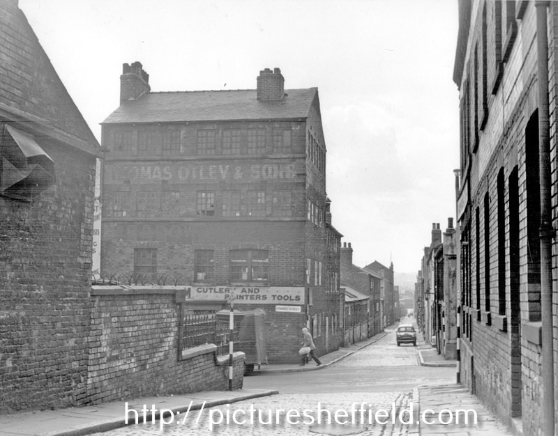
-
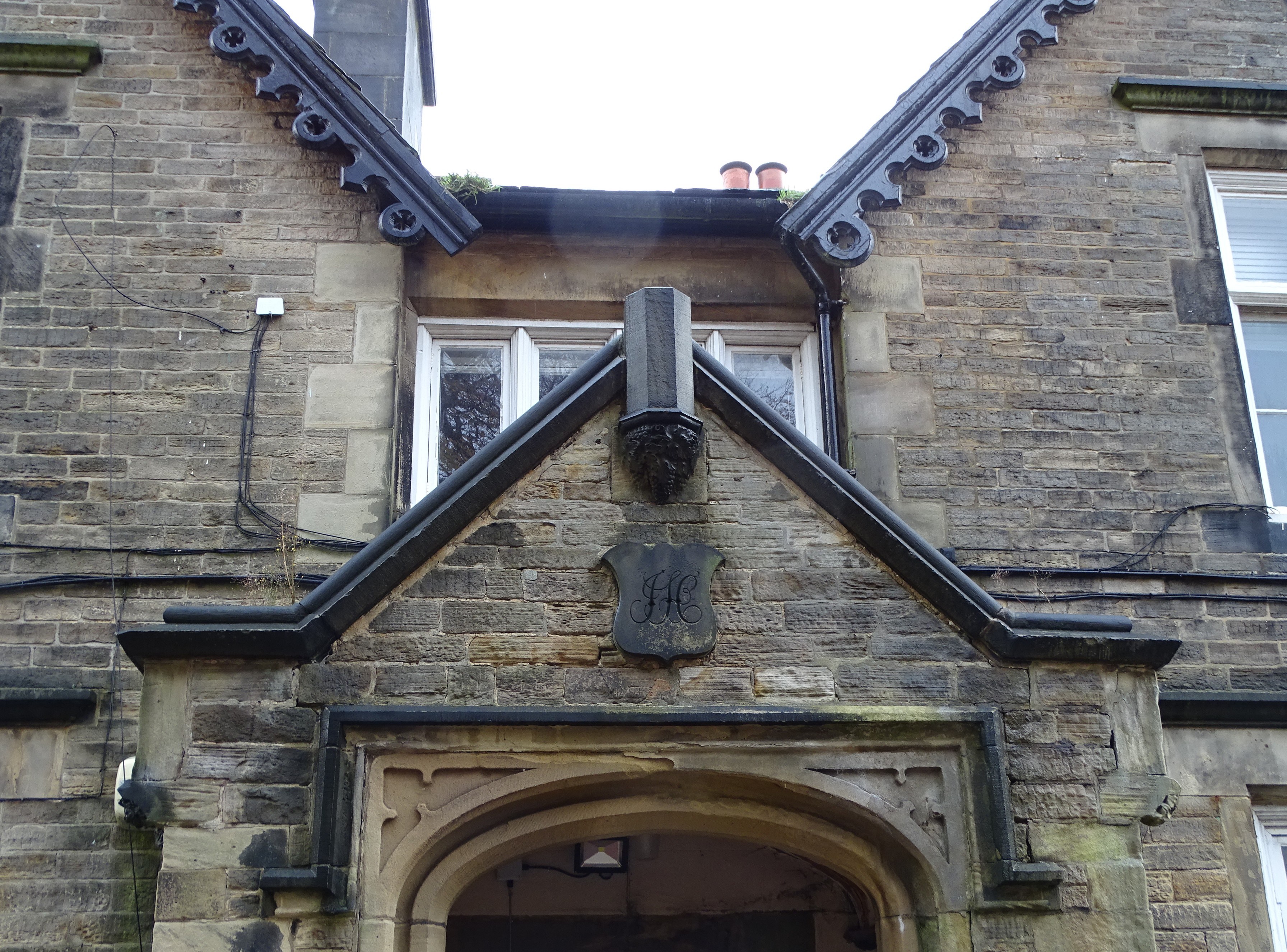
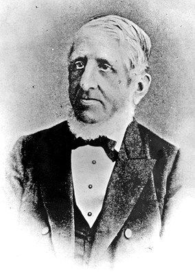
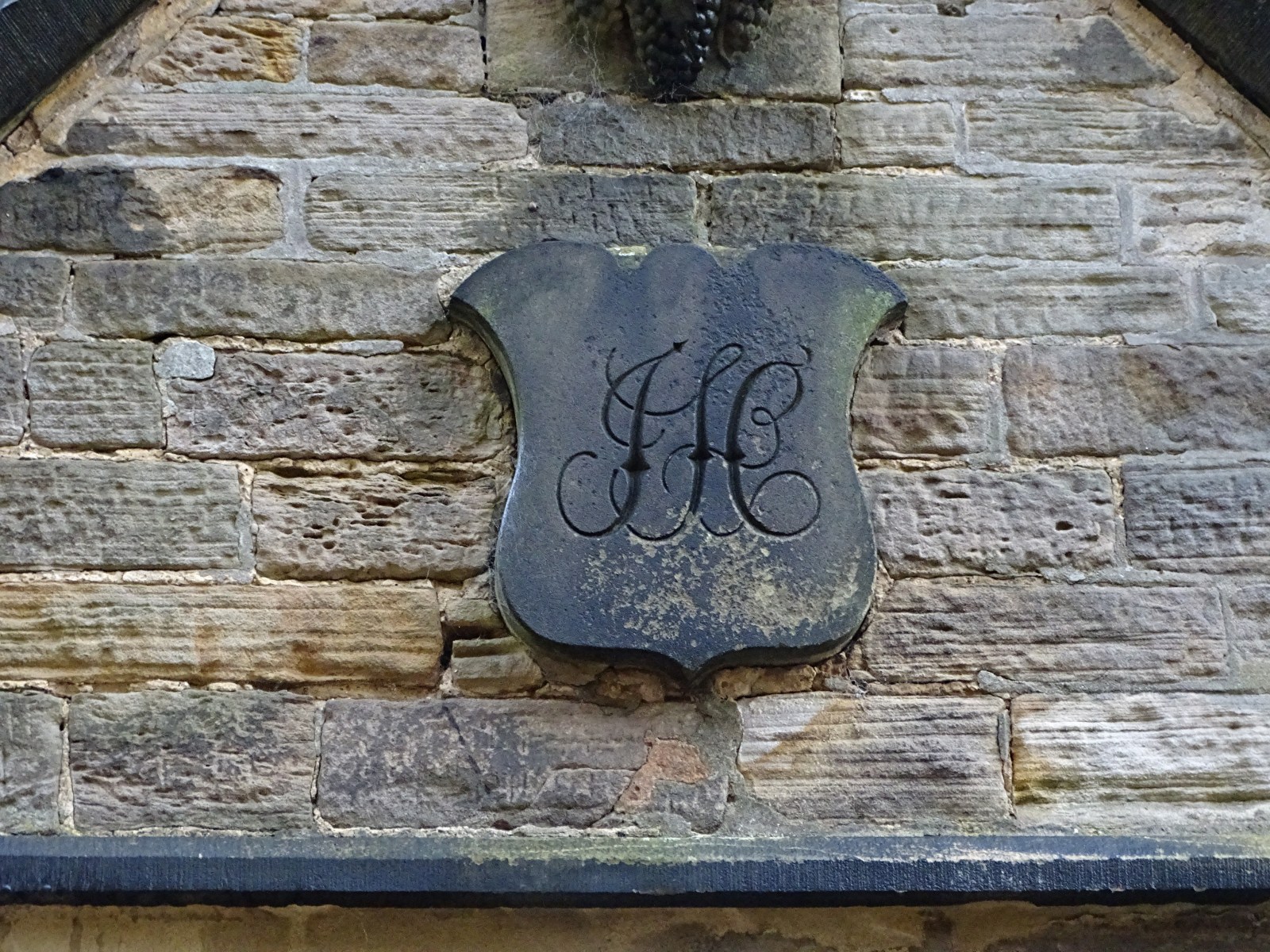
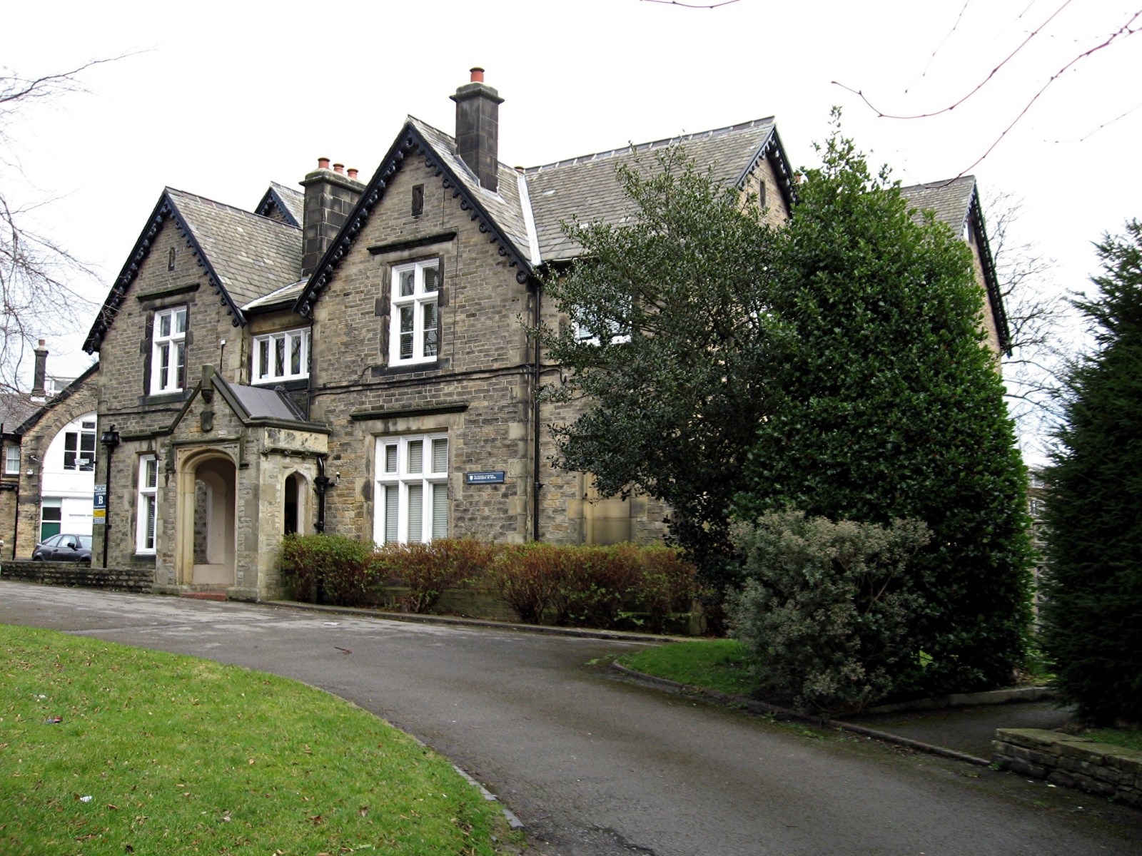
Mr John Hobson Scissor Manufacturer 38 Taptonville Road The finely worked initials of J H can be seen over the entrance to what was John Hobson’s front door at 38 Taptonville Road, the following pre-amble is from the great work done by the Broomhill Social History Group. In 1850 Sheffield was entering a period of major expansion and Broomhill was a favoured location for the homes of successful manufacturers and professional classes. In the 18th century the fields now occupied by Taptonville Rd were owned by Samuel Shore Esq., a local gentleman who lived in Tapton Grove, situated on Shore Lane where Tapton Hall (the Masonic Hall) now stands. A comparison of the 1851 map of the area with the present day illustrates how the pattern of the modern streets closely follows the pre-development field boundaries and lanes. Typically, the streets run through the centres of the original fields and the field boundaries are along the back garden walls of the houses. In 1850, Scissor manufacturer John Hobson purchased the fields that would become Taptonville Road and planned the development of the road, placing his own family home, Tapton Elms, in prime position on the highest ground at the head of the road. The gentility of the neighbourhood was assured by laying out the street with sizeable plots that were developed during the 1850s and 1860s with large, elegant houses of individual design standing in spacious gardens. Many of the successful industrialists in Sheffield were investing in property during this period. • No.1: was built in 1853 by Joseph Wright Bishop, one of a pair with 246 Fulwood Rd. • No’s 2, 4 and 6 were all built in 1855 by Robert Booth (originally a tailor, then property developer). • No’s 3, 5 and 7: were built in 1852 by William Greenwood, (property investor), who lived for a time in no.3 and then later in no. 5. • No.8 Built in 1861 by Charles Fleming (an engraver) as his own family home • No.10 Built in 1870 by J F Littlewood (a cooper) as his own family home • No’s 9 to 19: Built 1852 by George Deakin (originally a silversmith, then property developer) who lived for a while in no.17. The Hobson’s originated from Bradfield, the founder of the scissor empire, Joseph married a certain Miss Hinchcliffe who’s father was already making a good living producing scissors, Joseph Hobson is listed in the 1787 directory of the town, he was still in Bradfield at that time along with his son George, sometime before 1825 he had moved to Sheffield as he’s listed as a fine scissor maker, producing scissors from his works at 8 New Church Street, the yard where he made is scissors was named Hobson’s Yard after him, this street along with the yard was demolished and the present town hall was built over it, Josephs house was at 3 Surrey Street, it’s a strong possibility that he had access to the rear of his works from the rear of his house, by 1845, Joseph died on the 14th of September 1847 aged 75, the production was moved to 71 Arundel Street, his son John also moved house to 18 Surrey Street. I don’t know the circumstances but in 1879 John is working at 95 Arundel Street which probably stood near to where the Cossack stood, his old premises at 71 Arundel Street became the Talbot public house, which was run by two women, Miss Mary Norris and Miss Agnes Parsons in 1878ish. John Hobson’s family house was started in 1851 and completed in 1853. The gardens of Tapton Elms dominate the vistas north and south along Taptonville road. The ornamental garden to the south of the house’s principal façade has been lost under the two L-shaped disused student residence blocks now standing within this area. Further south, the half-acre walled kitchen garden of Tapton Elms has a highly decorative entrance gateway facing the street; all four boundary walls and gateways of this garden are still intact. Tapton Elms was the home for more than 70 years of the Hobson family. They were an old Sheffield family with a long history in the scissor manufacturing industry dating back to the 17th century .The Hobson’s’ business enterprises linked them to several of Sheffield’s best-known companies through a series of alliances and mergers, as well as trading under their own name for many years. For nearly half a century John Hobson drove the family business, it was known for its fine tailors shears and scissors, in the census of 1871 the firm employed 120 people half of which were women. John the driving force of the firm retired in 1882 and he died unexpectedly at Tapton Elms on the 20th of February 1889, after visiting his friend Frederick Mappin ( Mappin & Webb / Mappin's Brewery) at Thornbury, now Thornbury Hospital, as Tony Morton now knows after brilliant surgery there. The business was passed on to one of his sons, Albert, when John retired, who was just 21, this young man was severely crippled and could not walk without two strong walking sticks, when his father died he sold the business and order book to Joseph Rodgers, Albert along with his brother Wilfred joined the board of directors. Albert suffered great loss in the WW I his two sons, Leslie aged 19 was killed on 12th of July 1915 and his other son Alan lost his life on 28th of August 1916 age 23, for what? Tapton Elms is now being turned into flats by the look of it a sad end to a great house. I must point out that the history of Hobson & Son was gleaned from Geoff Tweeddale’s Directory of Sheffield Cutlery Manufacturers , thanks Geoff.

-
Greno House, School Lane, Grenoside. s05723 Advertisement for Education at Greno House near Sheffield. G. Rider BA of the University of Cambridge receives into his house a limited number of young gentlemen whom he prepares for the Universities and for the Professional or Commercial pursuits. Terms per annum. The pupils under eleven years of age 30 guineas. For those above that age 35 & 40 guineas. NB. No extra charge except for washing. The house is situated in a very beautiful & healthy part of Yorkshire four miles from Sheffield and four miles from Wortley. Coaches pass the House daily. A quarters notice and a quarters board previously to the removal of a pupil. Greno House, School Lane, Grenoside, February 1949. s05717 s05720 View from East. View from North East. https://www.picturesheffield.com/frontend.php?keywords=Ref_No_increment;EQUALS;s05721&pos=7&action=zoom&id=9134 View from South West. https://www.picturesheffield.com/frontend.php?keywords=Ref_No_increment;EQUALS;s05722&pos=8&action=zoom&id=9135 The Well. https://www.picturesheffield.com/frontend.php?keywords=Ref_No_increment;EQUALS;s05719&pos=5&action=zoom&id=9132 Pheasant Rearing House. https://www.picturesheffield.com/frontend.php?keywords=Ref_No_increment;EQUALS;s12031&pos=9&action=zoom&id=15037 s37340 Greno House, School Lane, Grenoside, July 1989. Latterly converted into 5 seperate dwellings. Former Stables. https://www.picturesheffield.com/frontend.php?keywords=Ref_No_increment;EQUALS;s37348&pos=2&action=zoom&id=73924


-
The Pheasant Inn (Beerhouse) / Stumble Inn
Ponytail replied to dunsbyowl1867's topic in Sheffield Pubs and WMC's
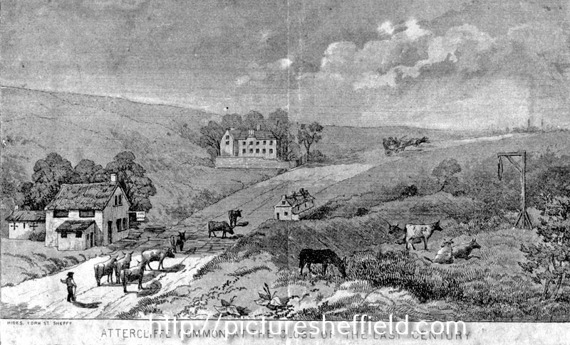
Artists impression of Attercliffe Common at the close of the 18th Century, near Greenland Engine Road (now Broughton Lane), buildings shown are the Arrow Inn, now pulled down, the Pheasant Inn and Carbrook Hall and gibbet post of Spence Broughton. t00983 Hides, engraver. On February 9, 1791 Spence Broughton along with John Oxley robbed the Sheffield to Rotherham postboy and stole the postbag containing a Bill of Exchange payable to Joseph Walker of Rotherham. Broughton was executed at York Tyburn and gibbeted at the scene of his crime where his remains hung for 36 years. Another Artists impression of Attercliffe Common at the close of the 18th Century. s13124 Engraver, Hides.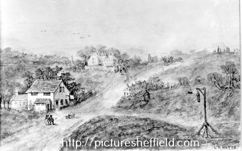
-
Former horse trough from Hunter's Bar, now in a field bounded by Hangram Lane and Cottage Lane. Hangram Lane Farm in background. June 1996. https://www.picturesheffield.com/frontend.php?keywords=Ref_No_increment;EQUALS;t02239&pos=4&action=zoom&id=32950 Snowy Sunset, Whiteley Wood Green, Sheffield. (The Old Horse Trough Was Formerly At Hunters Bar.) https://hedgerow.co.uk/image/type-general/searchstring-category%2525253ADERBYSHIRE/imgid-2760/ Horse Trough at Hunter's Bar. t08362 Entrance to Endcliffe Park, Ecclesall Road from Hunters Bar showing old horse trough (centre) 26th February 1933. Roundabout, Hunter's Bar, Ecclesall Road, showing the old horse trough. Entrance to Endcliffe Park, centre. 17th January 1955. https://www.picturesheffield.com/frontend.php?keywords=Ref_No_increment;EQUALS;s17488&pos=10&action=zoom&id=20198 Hunter's Bar showing Horse Trough 1904. https://www.picturesheffield.com/frontend.php?keywords=Ref_No_increment;EQUALS;s17486&pos=24&action=zoom&id=20196 Hunter's Bar, Ecclesall Road, from Junction Road. Endcliffe Park, left. Horse Trough, centre. https://www.picturesheffield.com/frontend.php?keywords=Ref_No_increment;EQUALS;t00986&pos=29&action=zoom&id=31812

-
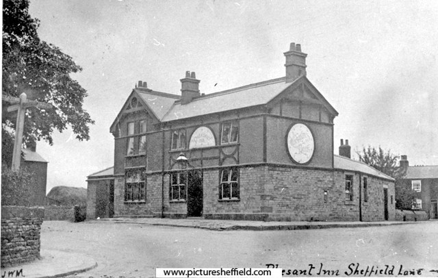
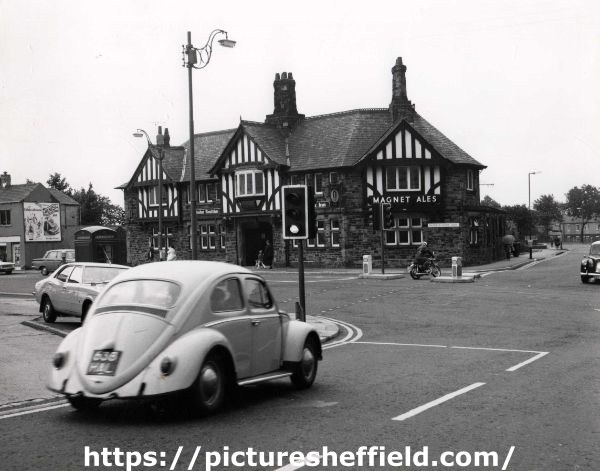
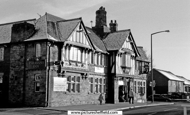
s06970 The earlier Pheasant Inn, Barnsley Road, Sheffield Lane Top. u11821 Pheasant Inn, No. 822 Barnsley Road, Sheffield Lane Top. 1973. Photographer: SCC City Engineer and Surveyors. c00564 Pheasant Inn, No. 822 Barnsley Road, Sheffield Lane Top. 19th November 2004.
-
Yorkshire mining and the Tavistock Institute
Viners replied to Roger Arevalo's topic in Sheffield History Chat
Is Elsecar Colliery near Barnsley a good candidate? I see that the same coal seam (Haigh Moor) would have been mined from multiple pits, which makes it harder to pin down the actual location. It sounds like the research on sociotechnical systems was done at a mine that Ken Bamforth had worked in before becoming more of an academic. If you can establish that he worked at Elsecar, that might help to confirm it. 1 Source: https://breadtagsagas.wordpress.com/tag/elsecar-collieries/ "These areas of concentration were the discovery and analysis of industrial democracy underground in the Elsecar Collieries by Trist and Bamforth. The development of the theory of sociotechnical systems based on this and on insights from psychology and the social sciences." Tavistock Institute gets a mention. 2 Source: https://en.wikipedia.org/wiki/Eric_Trist "Organizational research In 1949, his organizational research work, studying work crews in at Elsecar Collieries, with Ken Bamforth, resulted in the famous article, "Some Social and Psychological Consequences of the Longwall Method of Coal Getting." This article highlighted aspects of the miners organisation that today would be termed lean or agile." 3 Source: https://en.wikipedia.org/wiki/Elsecar_Collieries "Elsecar Main Coal extraction proper began at Elsecar Main between 1905 and 1908 when shafts were sunk to the Parkgate seam at 333 metres. Other seams worked were the Silkstone, Thorncliffe and the Swallow Wood seams. The Haigh Moor, Lidgett and towards the end of the colliery's life, Kents Thick seams were also mined. The colliery closed in October 1983." This all fits roughly with the location of South Yorkshire and the mine where the work practices were found being "a recently opened seam" as at 1950/51. Trist and Bamforth were probably researching multiple things and might have visited lots of different mines, so references and quotes might have become a bit muddled. I saw a couple of mentions of other locations, but they don't fit as good as Elsecar does. -
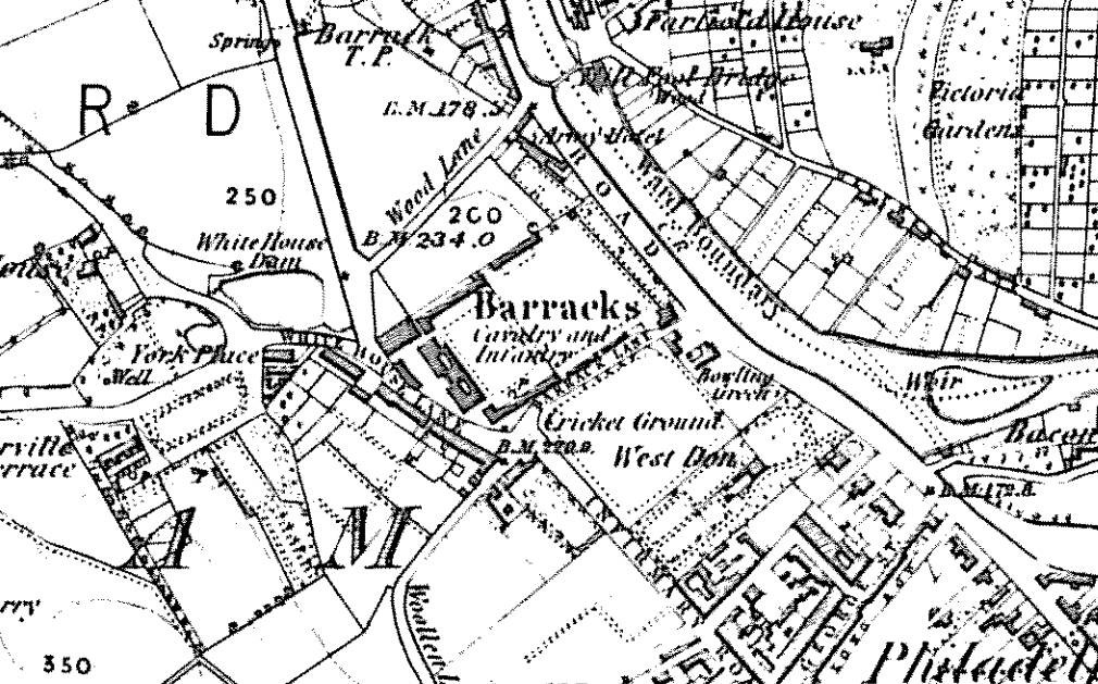
http://www.picturesheffield.com/cgi-bin/pi...ff.refno=s07451 http://www.picturesheffield.com/cgi-bin/pi...ff.refno=s18668 Apparently this property survived until 1992 and the widening of Pensitone road. It was the only survivng remnant of the old cavalry barracks built in 1792/4 and originally served as the barrack infirmary and officer's quarters. The old barracks site was bought by a partnership of builders in 1855 and used for the housing between Wood street and Barrack lane, incorporating Bertha street, Flora street, Gertrude street and Thirza street; - named, presumably, after female relatives of the builders. Part of the site was used to extend Infirmary road into Langsett road and so avoid the little detour up White House lane, which, according to a report in the Sheffield and Rotherham Independent at the time, was "exceedingly inconvenient".
-
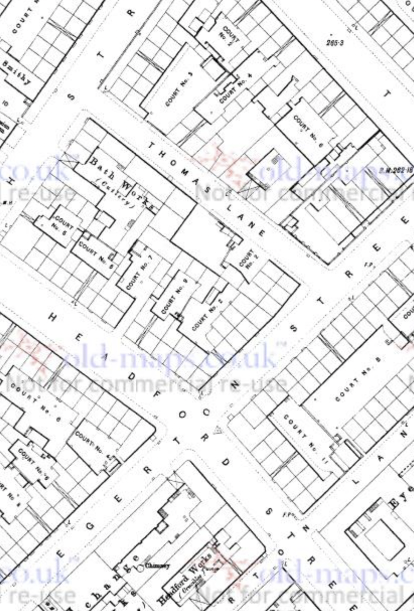
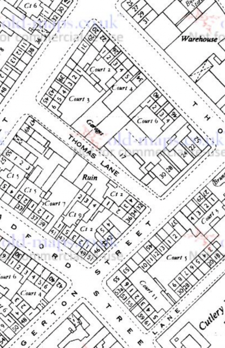
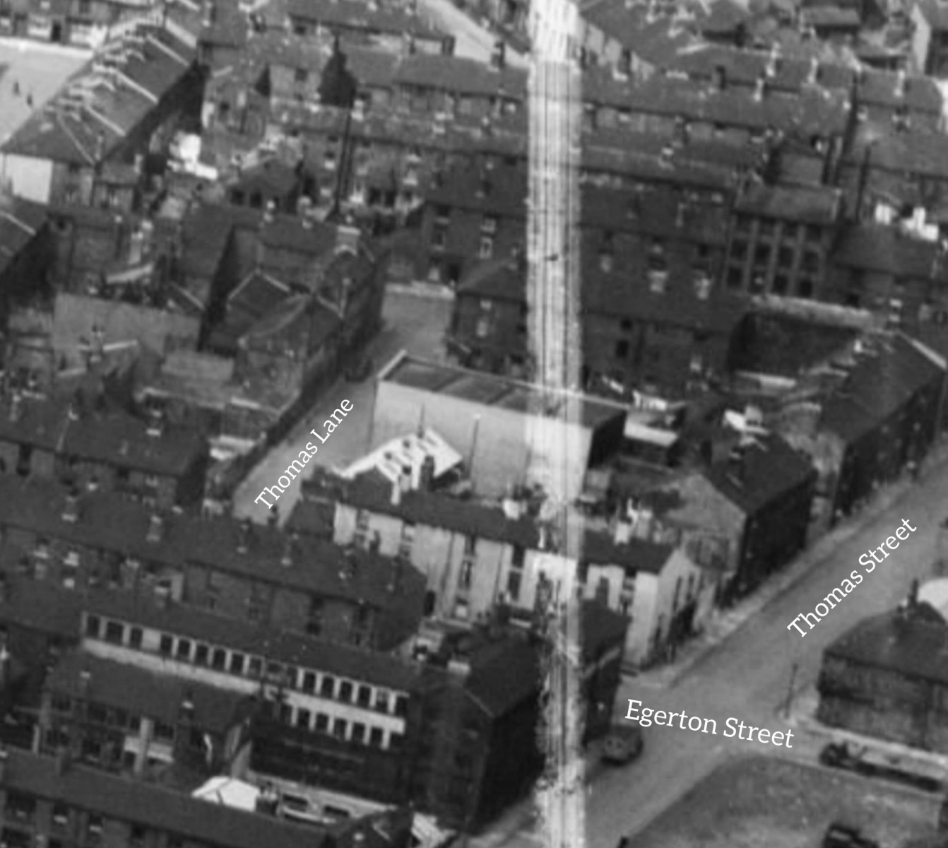
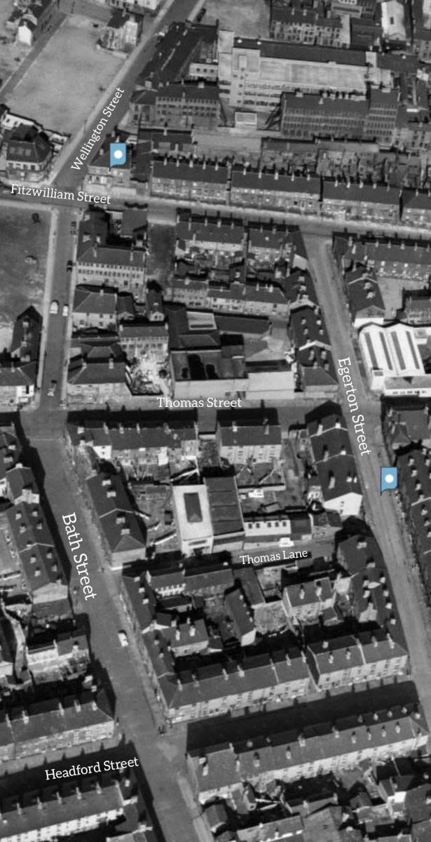
Afternoon all! I'm not sure if this is the right place for a request, but here goes. My Grandad's family lived on Thomas Street for a number of decades, stretching from around 1895 to the 1930s, but afterwards they relocated to Thomas Lane, which was a little Street between Bath Street and Egerton Street, Broomhall. Anyway, it turns out that they were living at number 5, as confirmed by both the 1939 Register, family documents, and a rather interesting newspaper article from that year. I've had a bit of trouble pinpointing the location of number 5 Thomas Lane, as there are no references to it being in a court, and no specific photographs of the street exist (I've included two from Britain from Above.) Even the 1905 Goad fire insurance maps cut off right before the street is covered! I was wondering if anyone on here knew any more about the area, or where the house might have been? Thanks, Lewis Waddingham

-
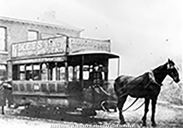
Boginspro, no doubt you will have seen this photograph. One Horse Tramcar, Single Deck No. 19. Tram for the Lady's Bridge, Saville Street and Brightside, outside the Bridge Inn, Brightside Lane. Car built by Starbuck of Birkenhead in 1874, withdrawn by 1901. s16296 Now in Corporation ownership note the word Company has been deleted. This picture was taken on or after 21st November 1896 the day that the Corporation took over the operation of the tramway service.
-
From the album: Chapeltown
-

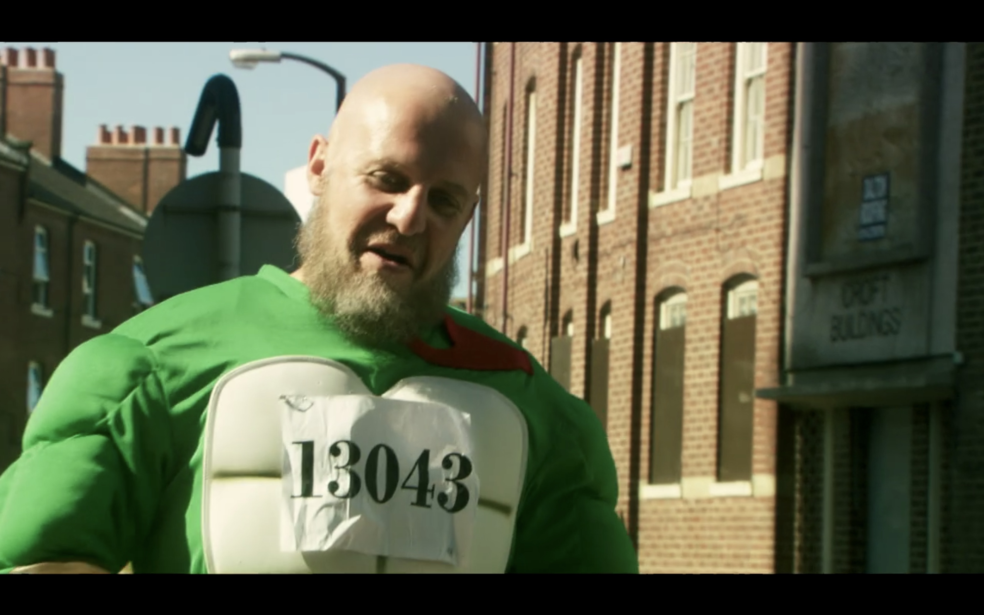
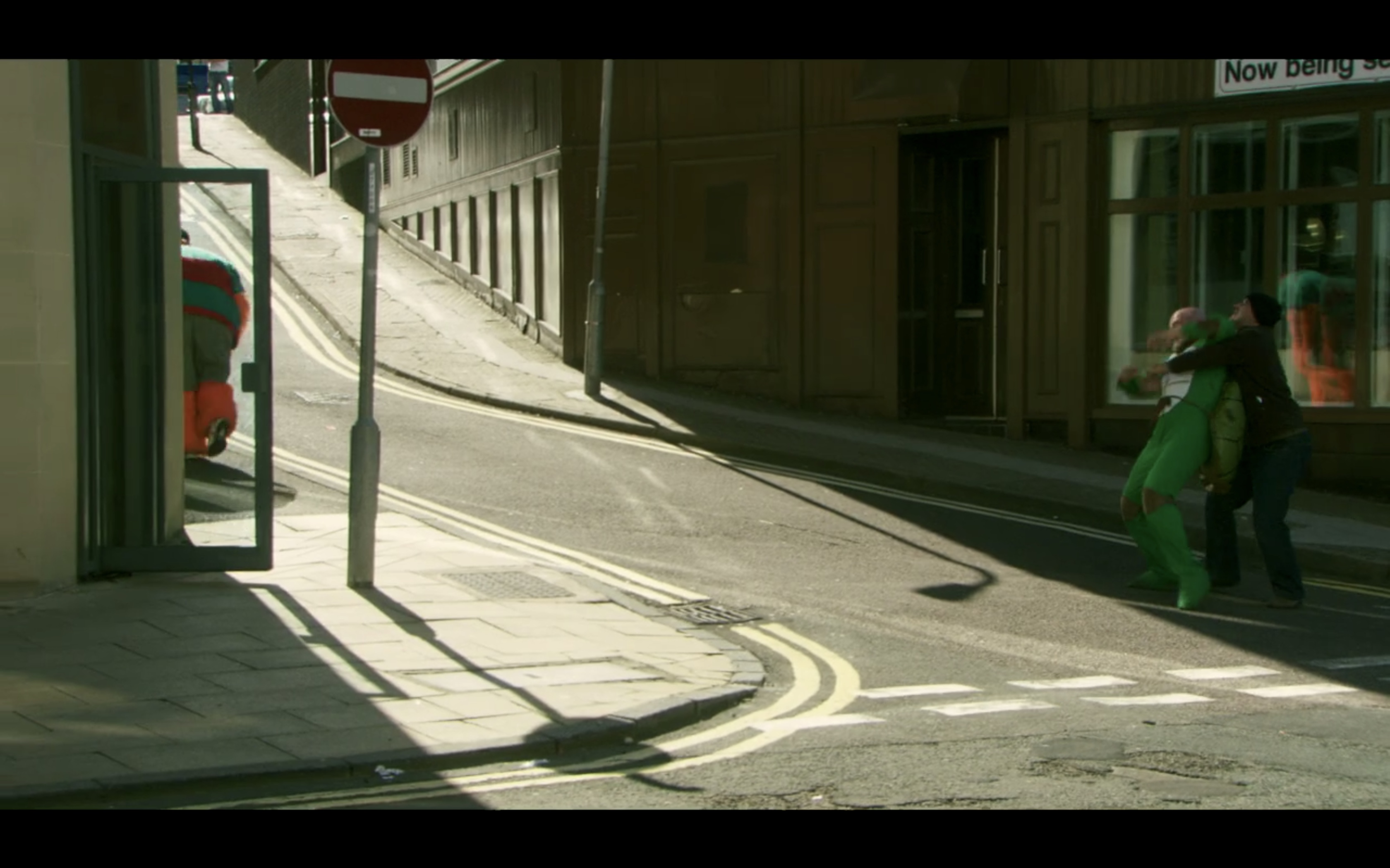
Barry confronts Omar outside Urban Deli on Campo Lane - Four Lions Filming Location
Sheffield History posted a topic in Four Lions Filming Locations
FOUR LIONS FILMING LOCATION - CAMPO LANE This scene is another cracker as Barry finds Omar in Urban Deli on Campo Lane Barry decides to eat his sim card but ends up choking on it with explosive results!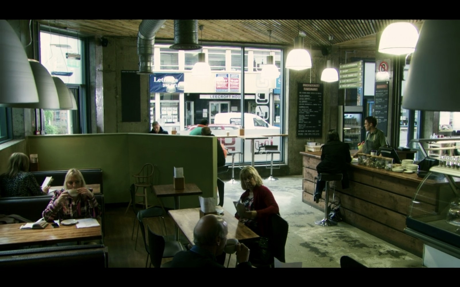


-
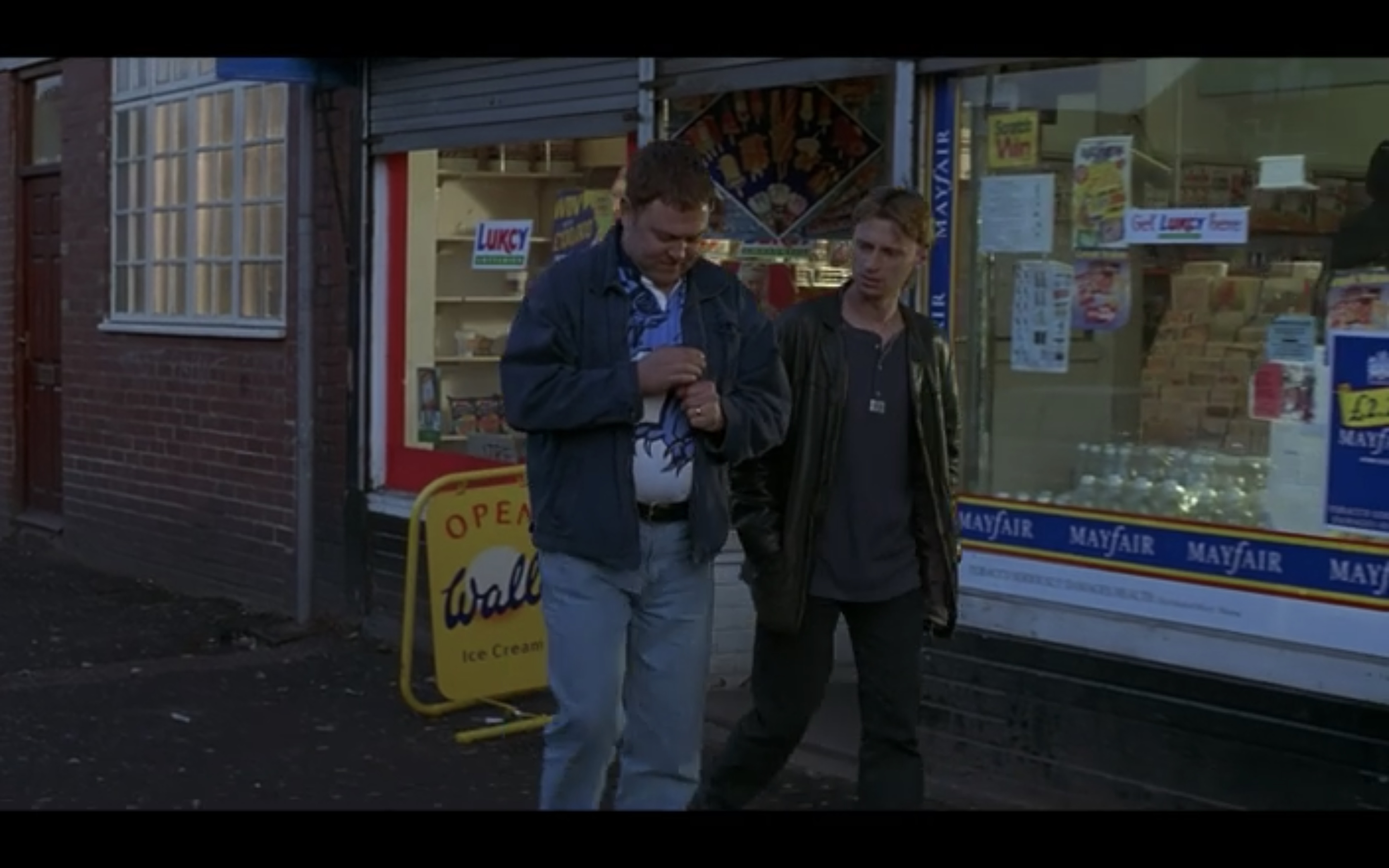
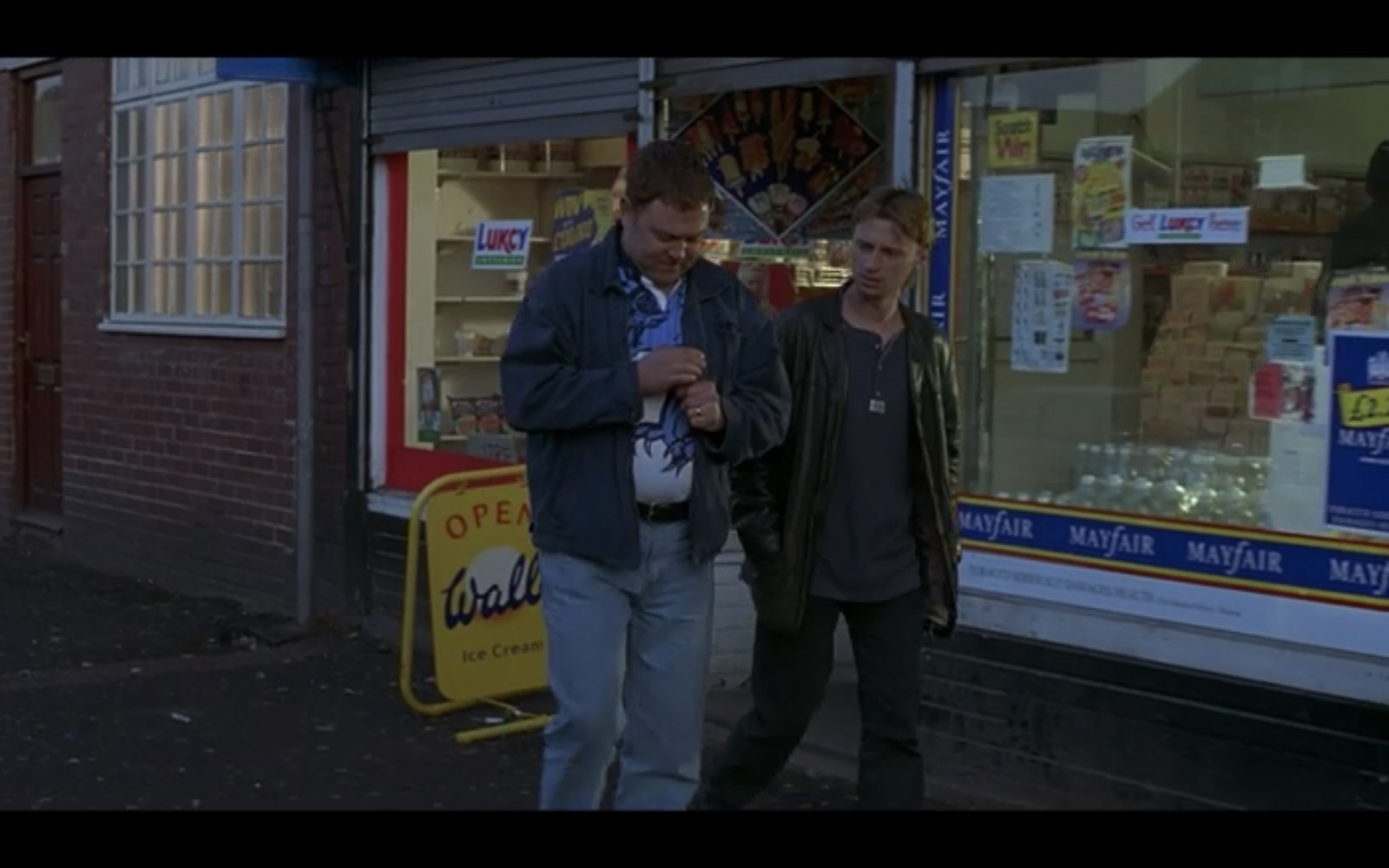
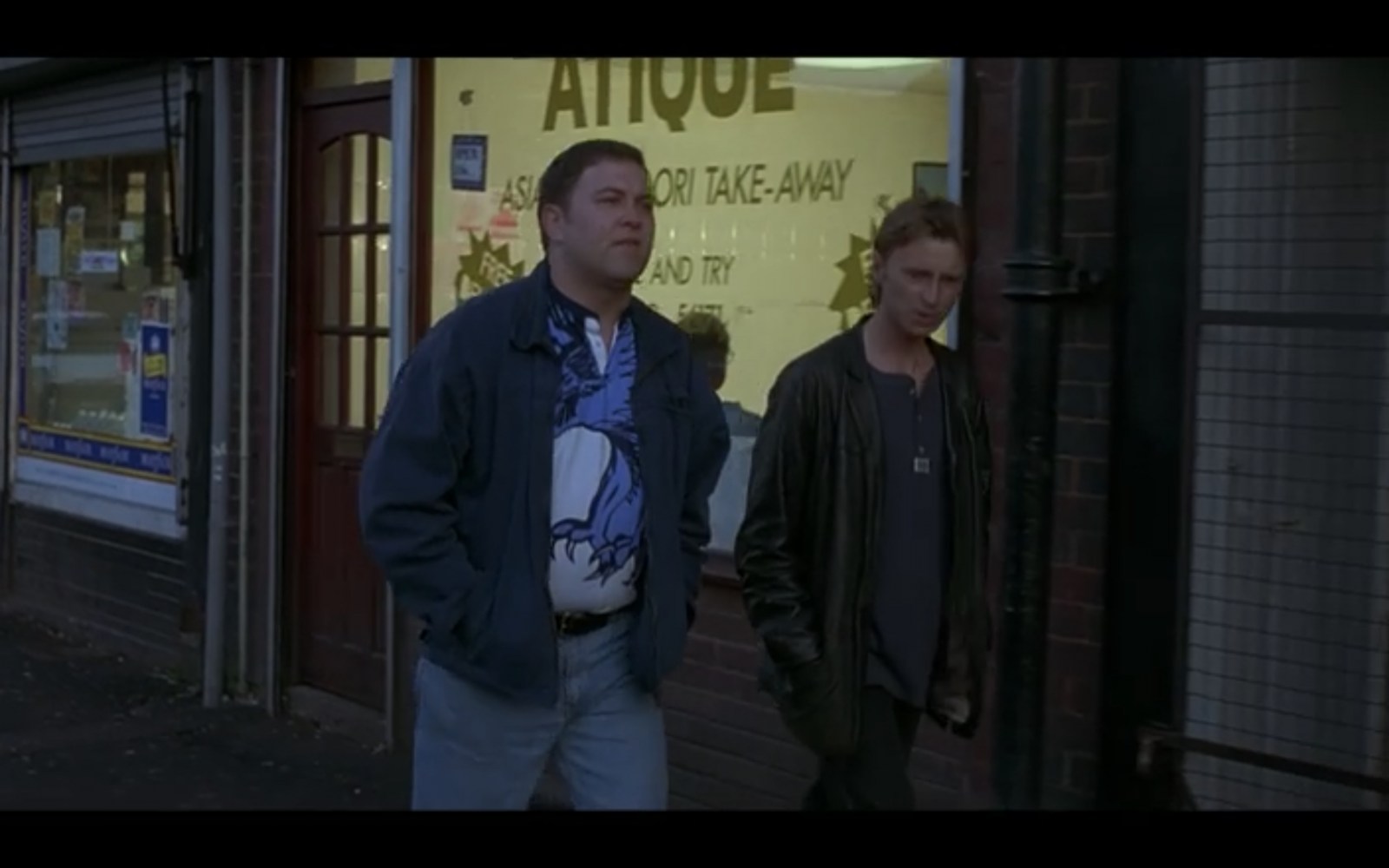
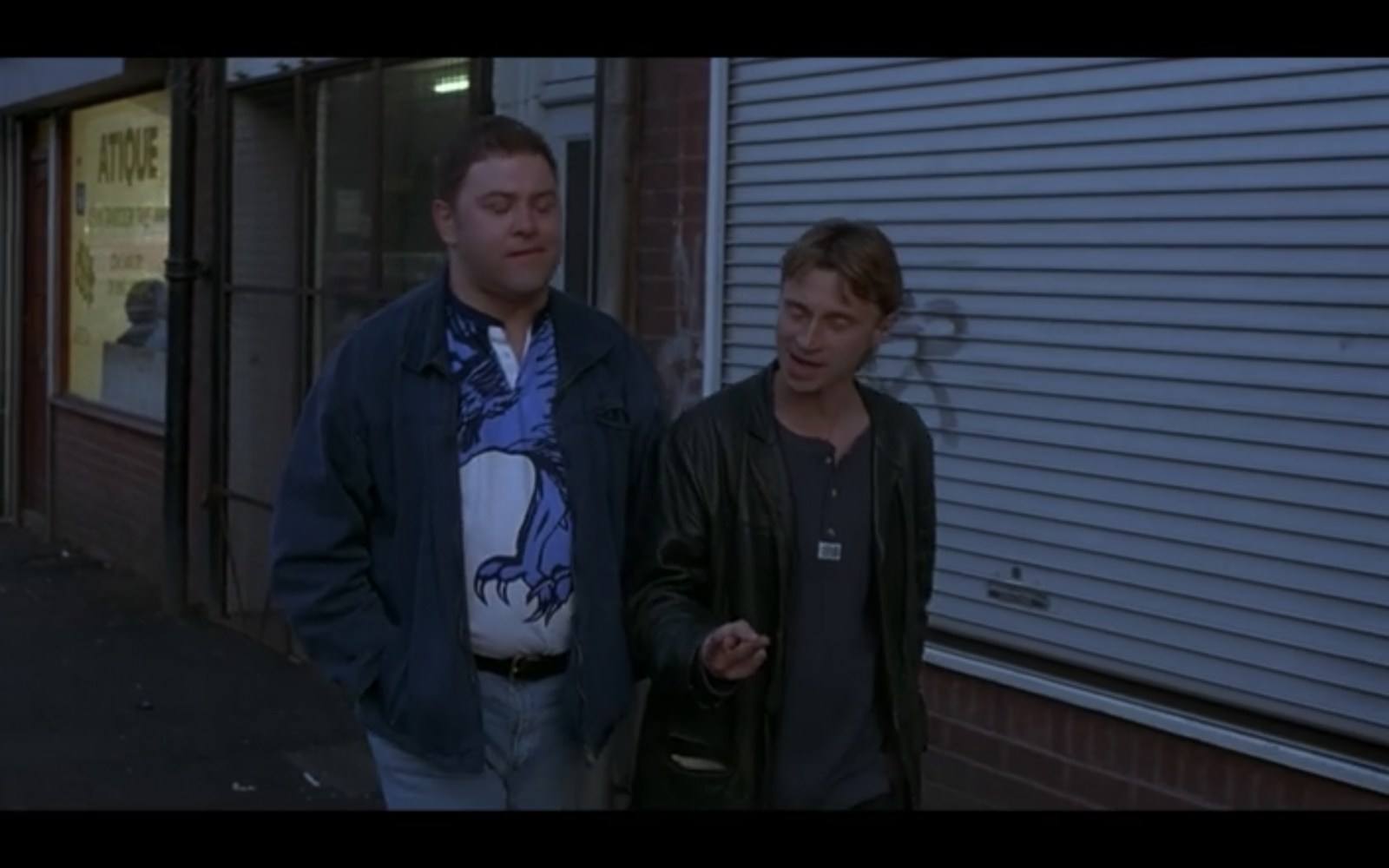
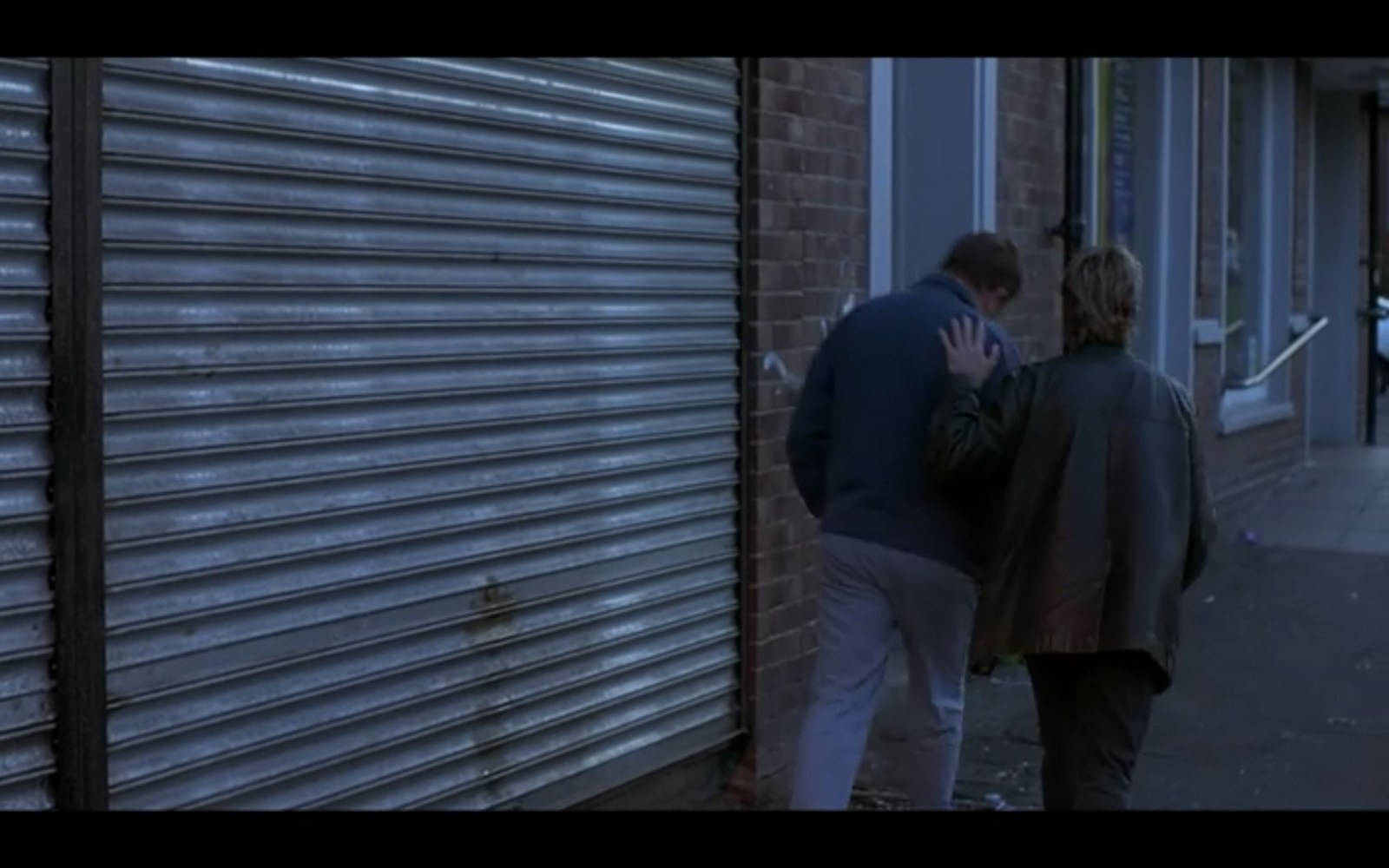
Stubbin Lane Sheffield - The Full Monty Filming Location
Sheffield History posted a topic in The Full Monty Filming Locations
The Full Monty Filming Location at Stubbin Lane, Sheffield Here we see Dave (played by Mark Addy) and Gaz (played by Robert Carlyle) walking along a row of shops chatting. The actual filming location is Stubbin Lane in Sheffield See below...
-
Dixon Lane in Sheffield City Centre
Ponytail replied to Sheffield History's topic in Sheffield History Chat
Shame this photograph isn't in colour. Rock Tavern, No. 20 Dixon Lane, 1969. s21769 From: https://www.closedpubs.co.uk The Lost Pubs Project. Rock Tavern. https://www.closedpubs.co.uk/yorkshire/sheffield_s1_rock.html Pub History.com Rock, 20 Dixon Lane. https://pubshistory.com/Yorkshire/SheffieldR/RockDixon.shtml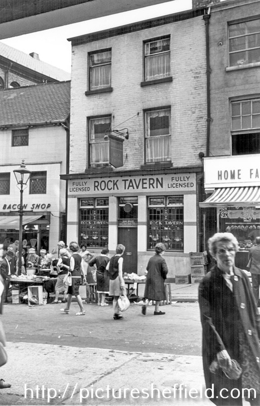
-
The question was raised where Forge Lane was in the Pond Street area. Thanks to Archives and Local Studies who are digitilising maps making them available on line through the Picture Sheffield website, thought this may prove helpful. Part of Shude Hill is also marked. Please note the spelling is as it is on the map. A map of the dams, goights and other works belonging to the Pond Forge Co together with some other intermediate properties. 1820. Boardman's Bridge, wear [weir], Porter Brook, goight, River Sheaf, Upper Dam, Sheaf Lane, bridge, Upper Forge Wheel, dam, Upper Forge, Sheaf Mill, steam engine, Lower Forge, grinding wheel, arched goight, tail goight, Shude Hill, Hospital Bridge, hospitals, Sheaf Bridge, Castle Orchards Wear [weir], River Dun [River Don], Pond Street, Forge Lane, Pond Well Hill. Late Joseph Ward, John Hounsfield, Josiah Blackwell, late Abraham Wright, S. Woodcock and Sons, Joseph Blackburn, Thomas Mearbeck and Co., S. Rawson and Co. [?Thomas Rawson and Co], Joseph Shimmeld, John Vickers, Sheffield Gas Light Co., S. and S. Darwin, Sarah Beeley, Widow Beardsall, John Hale, Widow Badger, and J. B. Ward. https://www.picturesheffield.com/frontend.php?keywords=Ref_No_increment;EQUALS;arc04213&pos=13&action=zoom&id=105197 And another map, a bit harder to read but the tenants/owners of the properties are named in the notes.... Thank you Archives and Local Studies. https://www.picturesheffield.com/frontend.php?keywords=Ref_No_increment;EQUALS;arc04212&pos=12&action=zoom&id=105190
-
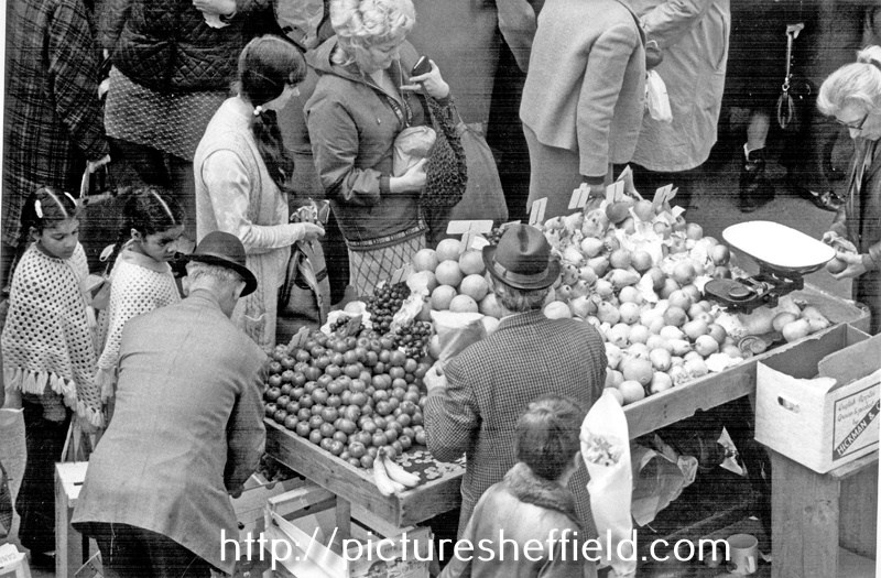
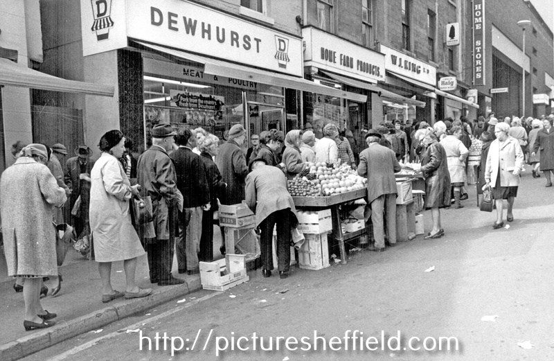
Dixon Lane in Sheffield City Centre
Ponytail replied to Sheffield History's topic in Sheffield History Chat
Market Stall, Dixon Lane. t09689 Market Traders 1965. https://www.picturesheffield.com/frontend.php?keywords=Ref_No_increment;EQUALS;s41926&pos=85&action=zoom&id=81905 Market Stall on Dixon Lanet02350 Photographer: Fell. Market Stalls, Dixon Lane and No. 20 J.H. Dewhurst Ltd., butchers; No. 18 Home Farm Products Ltd., pork butchers; No. 22 W.J. King Ltd., provision dealers. t01676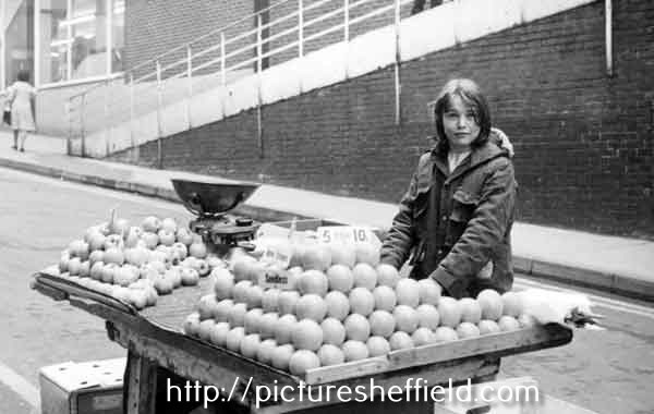
-
The Hole In The Road Sheffield
Stasro replied to Sheffield History's topic in Sheffield History Chat
two comments to add to the discussion - 1 This area of the city Centre took quite a pounding during the war with Marples Hotel on Fitzalan Square taking a direct hit and the old C&A building being bombed out. That is why there was a row of single-story shops across the end of what was Change Alley. It took many years' work to put that all to rights. 2. The delays due to the old coal seam were due to the Coal Authority having "first dibs" on any coal found in excavations and they always took their time deciding whether they wanted it or not. -
I wonder if anyone remembers the above? We called it the "drink shop" and it was run by "Aunt" Gladys and her sister. This tiny shop, with a bench seat along one wall,was where we bought our 2 oz of rationed sweets, our ice cream cornets, pop and ,when available, a glass of sarsparilla. Aunt Gladys was a lovely woman who, having one of the first TV sets in Firth Park, would occasionally invite a few of us regular kids into her back room to watch BBC Childrens TV and have ,as a treat, one of her home made ice lolly's.
-
This also shows "Foresters" (left) don't know whether it something I'm doing/not doing, unable to get the Zoom to work to enable text legible. Possibly reads John Green. Plan of Messrs Brownell's freehold property in and near Carver Street, Sheffield. 1845. https://www.picturesheffield.com/frontend.php?keywords=Ref_No_increment;EQUALS;arc04077&pos=8&action=zoom&id=98738 By J. Fairbank and Son. Endorsed: This plan is drawn from an old survey. Shows Rockingham Street, West Street, Carver Street, Rockingham Lane, and Division Street. Tenants / owners: John Green, Samuel Laycock’s executors, Society of Methodists [Carver Street Wesleyan Chapel], John Moulson, Joseph Moulson, William Moulson, Edwin Moulson, Henry Duke, Francis Carr, Fenton and Shore, Bush and Broomhead and Nadin, Charles Brown, and Sorby and Sons.
-
Shirland Lane Sheffield - The Full Monty Filming Location
Sheffield History posted a topic in The Full Monty Filming Locations
This shot of our characters walking up a hill was incredibly difficult to pin down but I did it (eventually!) This shot was achieved by the cameraman being quite a way away from the actors but zoomed right in on them, and the 'hill' wasn't actually a hill they're walking up but was the hump of a bridge between the cameraman and the actors! This actual Full Monty Filming Location is Shirland Lane which is in the Attercliffe/Darnall area of Sheffield The pub seen to the left is no longer a pub See below for the actual Sheffield location and what it's like now!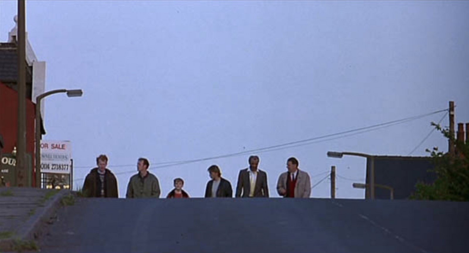
-
Hi Steve. Yes! you are right! On the old picture postcards, I have found a good few mistakes on the name given to places in our area. They put Forge Dam, Endcliffe on one. Another, had a dam in Endcliffe down as Whiteley Woods. A view taken 'FROM' Woodcliffe, looking over 'TO' Quiet Lane, said from Quiet Lane looking over to Woodcliffe. Plus more:-..... I think it is that in a lot of cases, the old photographers didn't really know the area, and what boundary was where. Also I have found, people made notes of the places they had been photographing, but somehow, put them on the wrong picture. Regards Heartshome
-
Hello I'm trying to unlock a family mystery and I hope by researching some addresses, who lived there etc in certain years will help me. Any information that would shed light. I would like advice on which records would give be the best information. I’m assuming it would involve a trip to the local studies library so I would like to have a plan before I make the journey to Sheffield. The addresses and years are; 1876 12 ct 17h Bernard St 1887 Castle Court 7 Sylvester Lane 1887 8 Castle Yard, could be 251 or 285 1891 32 ct 3h Fitzwilliam St 1909 1 Regent Lane 1913 25 ct 3h Thomas Street Also was there a different numbering system also use such as for example 13 house 2 court also referred to as 250. Many thanks!
-
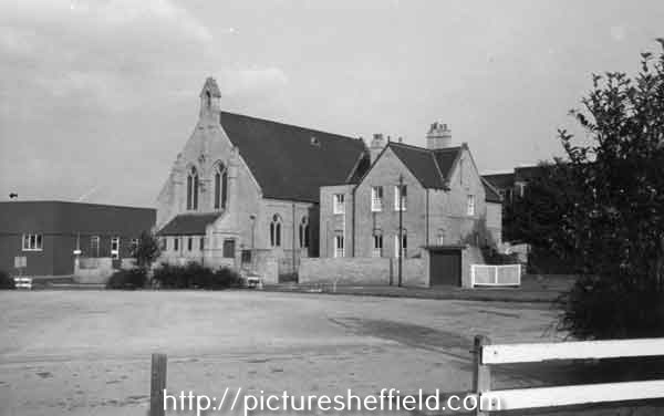
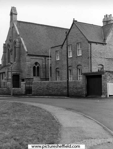
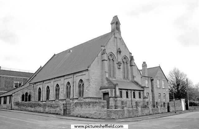
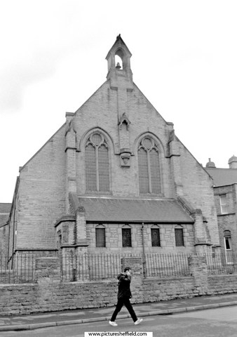
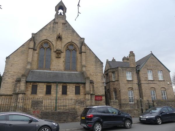
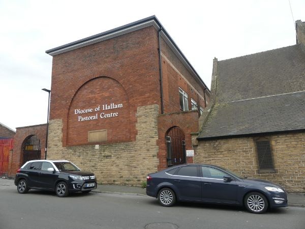
Catholic Church of St Charles, Attercliffe
Ponytail replied to dunsbyowl1867's topic in Sheffield History Chat
St. Charles Borromeo, Roman Catholic Church, St. Charles Street. Who was Charles Borromeo? https://en.m.wikipedia.org/wiki/Charles_Borromeo Taking Stock: https://taking-stock.org.uk/building/sheffield-st-charles-borromeo/#:~:text=It was dedicated to St,Serpentine in London in 1867. Sketch of St. Charles Borromeo Churchs05094 Plan of St. Charles' Borromeo Roman Catholic Church and School, St. Charles' Street, Attercliffe. 1876. https://www.picturesheffield.com/frontend.php?keywords=Ref_No_increment;EQUALS;arc04439&pos=94&action=zoom&id=151810 Church and Presbytery, St.Charles Street. 1987.t08439 u08403 28th January 2005.c00816 Photographer, David Bockingc00817 2021a07116 Photographer, Andrew Milroy Pastoral Centre, Roman Catholic Diocese of Hallam, St. Charles Street. 2021. a07115 PhotographerAndrew Milroy Plaque on Diocese of Hallam Pastoral Centre, Heppenstall Lane. 2006. https://www.picturesheffield.com/frontend.php?keywords=Ref_No_increment;EQUALS;t10471&pos=9&action=zoom&id=91432 St. Charles School, built 1871, rebuilt 1929 in memory of the Very Revd. Joseph Hurst V.F., founder and first rector, 1866-1905. St Charles Borromeo Roman Catholic Church, Sheffield, Parish Records. https://discovery.nationalarchives.gov.uk/details/r/76a87f80-ae50-499b-8153-d3d3cf131a64 Local Heritage List. https://local-heritage-list.org.uk/south-yorkshire/asset/7598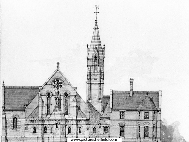
-
Flood Claim Link Restored: Henry Greenwood. Beerhouse Keeper, "Paddy's Goose", Love Lane, Sheffield https://sheffieldfloodclaimsarchive.shu.ac.uk/claimSummary.cfm?claim=7-5885