Search the Community
Showing results for 'coal pit lane'.
-
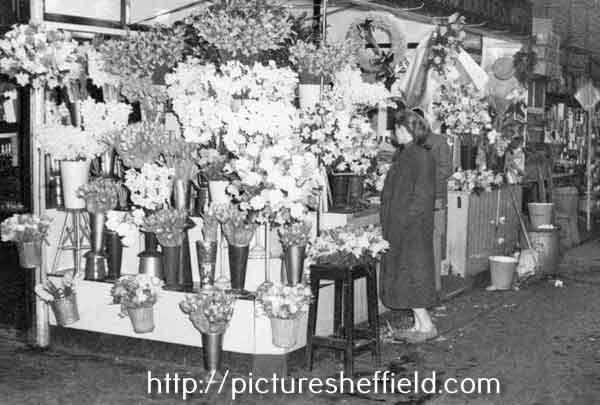
Plan showing the Balloon Tavern, Sycamore Street. Plan of the premises in Arundel Street and Sycamore Street belonging to Parker, Potts and Denton, and of the adjoining premises belonging to James Hibberson, 1827. https://www.picturesheffield.com/frontend.php?keywords=Ref_No_increment;EQUALS;arc04033&pos=293&action=zoom&id=103278 Shows Arundel Street, [Arundel Lane], Sycamore Street, foot road from Pond Street, John Wilson's furnaces, stable, carriers warehouse, counting house, brewhouse, gateway, house, passage, Balloon Tavern, workshops, merchant's warehouse, etc. Sheffield History A-Z Public Houses Listing. Balloon Tavern, 21 Sycamore Street Open. 1825 or earlier, Closed. 1900 Span. 75. 1825. William Baker 1828. William Baker 1830. William Baker 1833. Francis Chambers 1834. Francis Chambers (died 18/2/1837, Lung inflammation, aged 49) 1854 Joseph Birks [6 Sycamore Street]
-
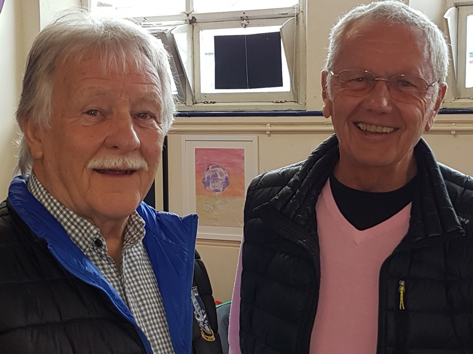
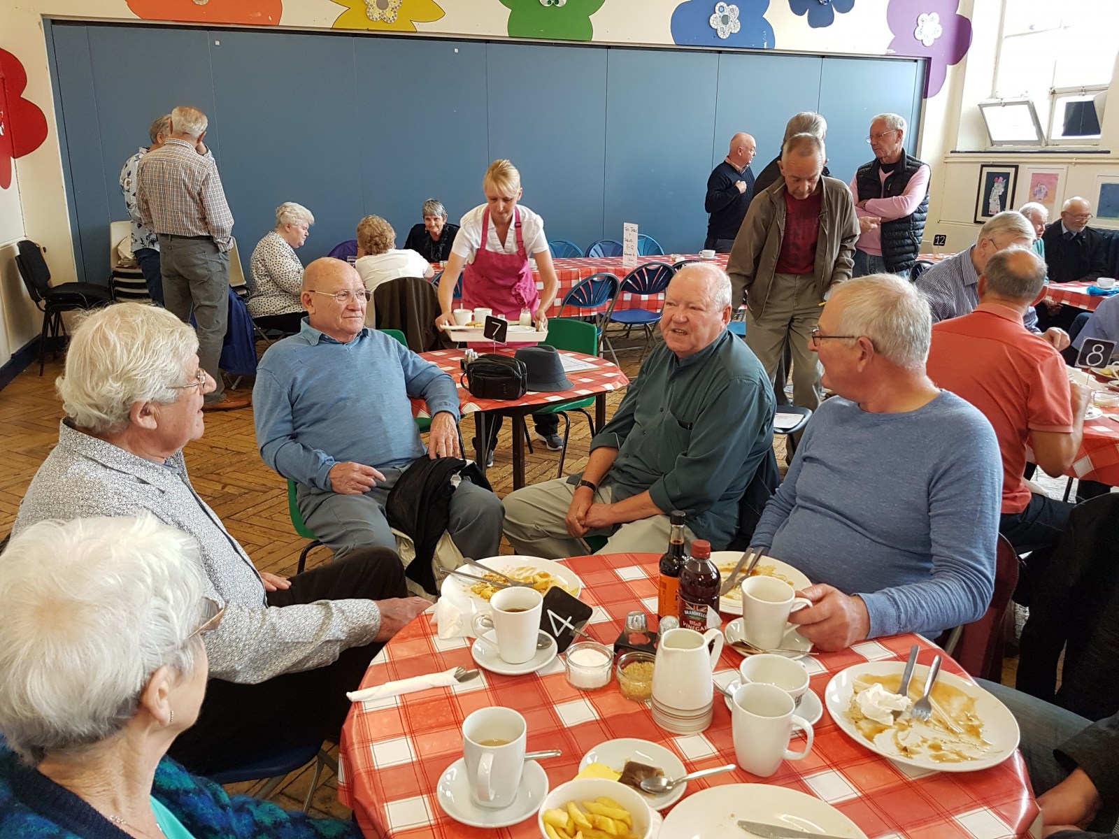
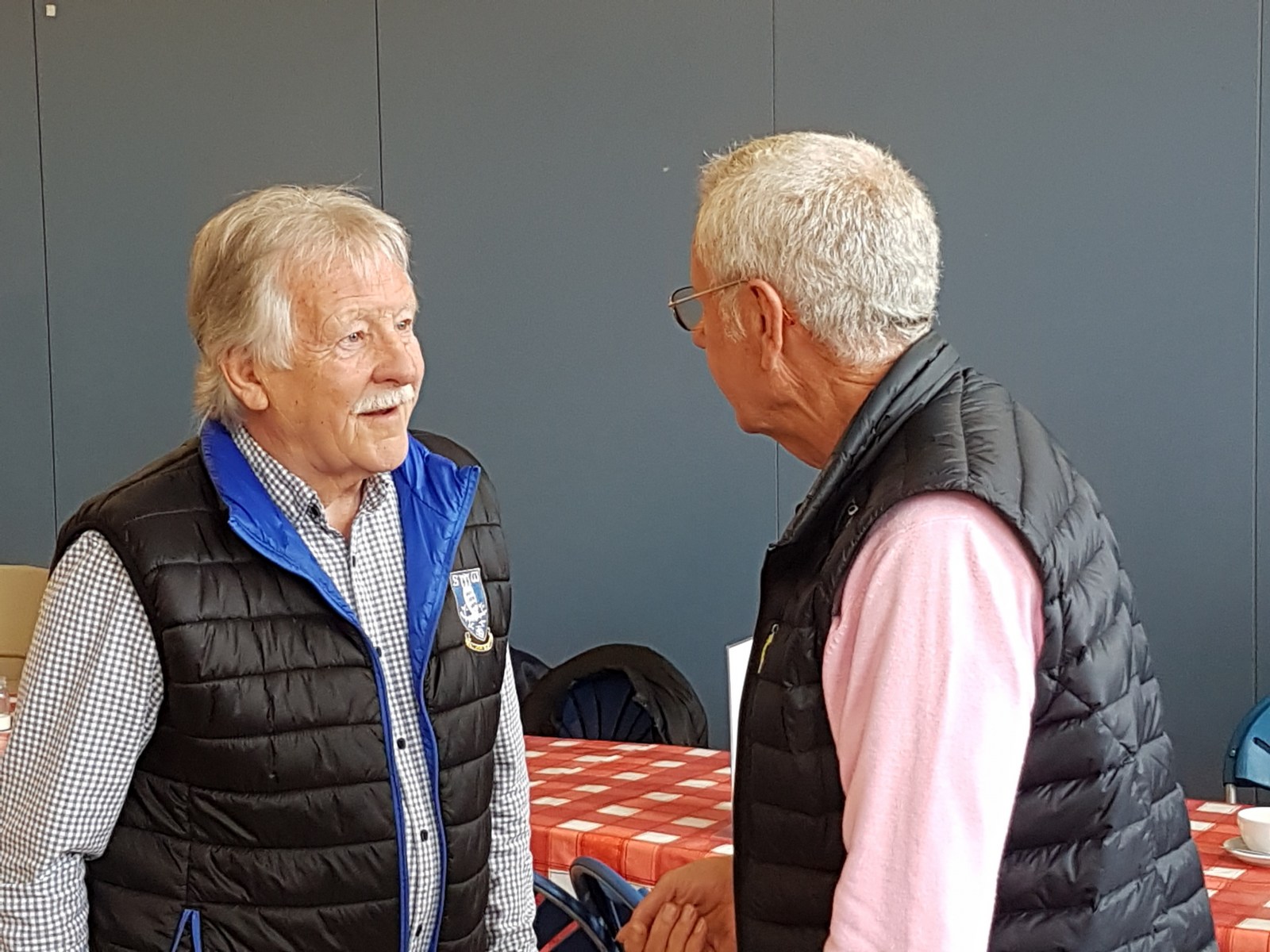
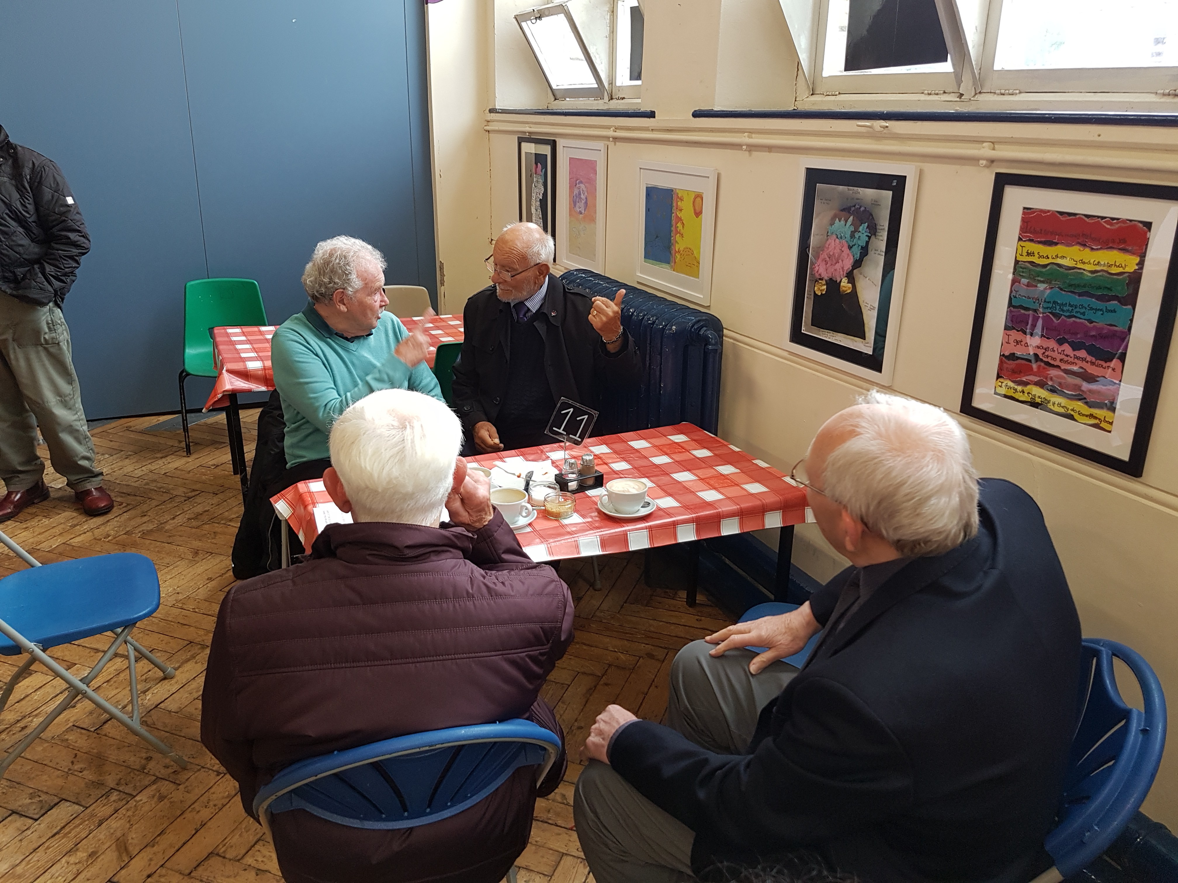
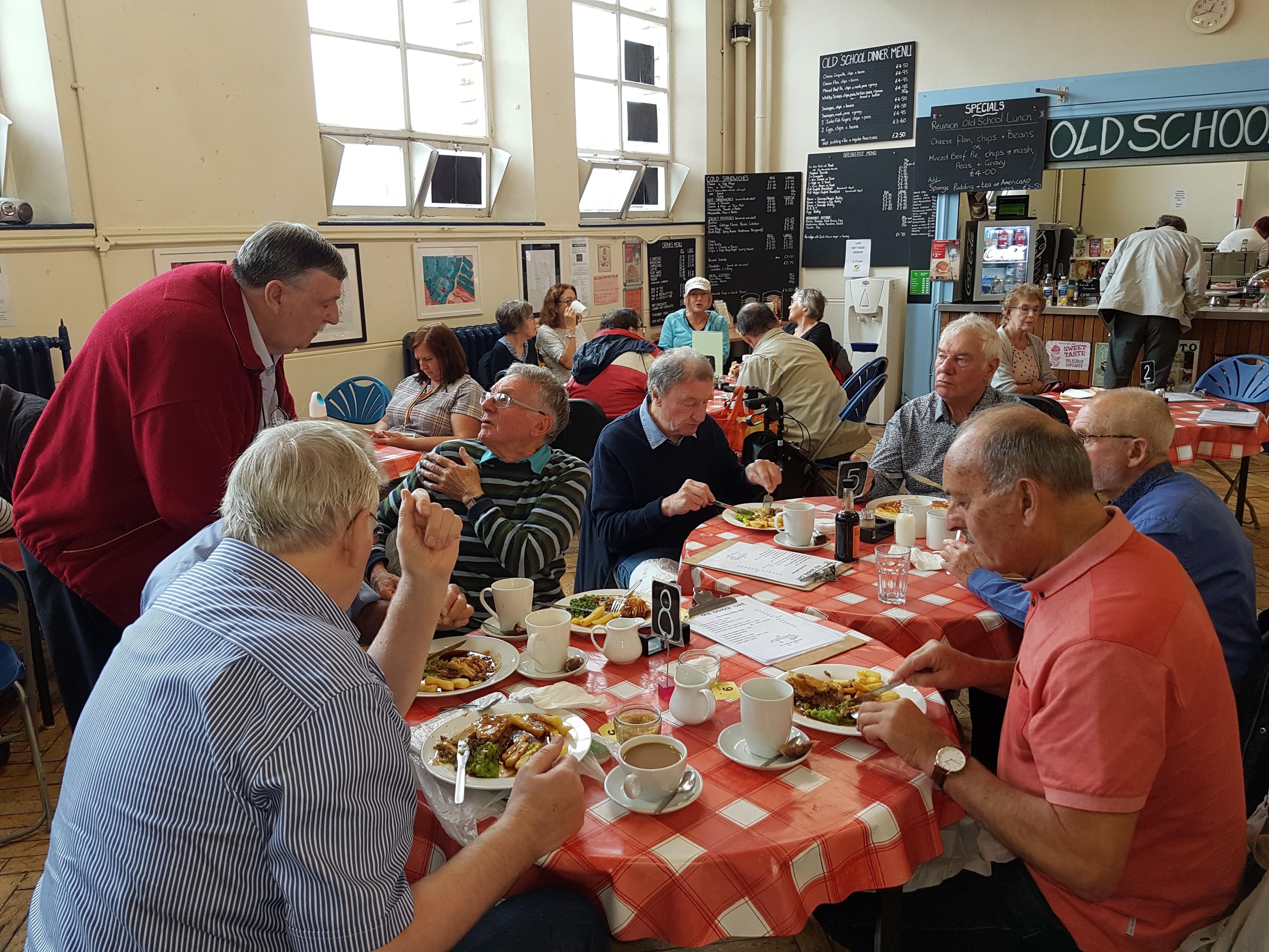
Finally I have a few minutes to report on the latest Sharrow Lane School Reunion held on Wednesday 26th June. Altogether 29 former pupils and Sharrow residents turned up, the youngest aged 71 and the eldest, I think, 85. We had a terrific two hour session of exchanging memories and revelling in the atmosphere of the old Junior School Hall. With their permission, here is a list of those present: (The ladies consented to using their maiden names) Valerie Shaw; Christine France; Brian Milner; Tony Ford; Denis Anson; Mick Glossop; Jack wade; Alan Barnett; Tony Faulds MBE; Dave Holmes; Dave Storf; Ian Brelsford; Malcolm Gladwin; Ralph Holmes; Frank Turner; keith Spooner; John Beatson; Tony Hardwick; Roger Walker; John Smith; Phil Smith; Roger Stevenson; Graham Whitham; Darrell Whitham; Pauline Mackreal; Diane Goodwin; Ronald Hibbert and myself, David France. It was soon agreed that there should be another reunion later this year and so it has been decided there will be a special Christmas Lunch event at 1pm on Wednesday 27th November 2019 but places MUST be pre-booked through me. A price for the lunch will be published nearer the date. Watch this space! The photographs here show what a cordial and relaxed event it was. Book your space for November now by sending me a personal message.


-
A plan of sundry Tenements in Jehu Lane with the Carriage Road proposed to be made for their accommodation through the Ground held of the Earl of Surrey by Robert Lambert. 1783 Surveyor: William Fairbank II. Tenements bounded by Jehu Lane, Baker's Hill and Shude Hill. Tenants; measurements given of the area concerned in the making of the new lane (unnamed). (Fitzalan Square) https://www.picturesheffield.com/frontend.php?keywords=Ref_No_increment;EQUALS;arc03167&pos=9&action=zoom&id=98189
-
Map showing Jehu Lane. Plan of Baker's Hill and Shude Hill shewing a proposed improvement there with a section of Baker's Hill and part of Shude Hill. 1840 J. Fairbank and Son. Shows Fruit Market, Hay Market, Market Street, Jehu Lane, Bakers Hill, Norfolk Street, Flat Street, Pond Street, Forge Lane and Shude Hill. https://www.picturesheffield.com/frontend.php?keywords=Ref_No_increment;EQUALS;arc04038&pos=4&action=zoom&id=103298
-
Map shows how the planned new street sweeps away the properties on Jehu Lane. Plan of proposed new street [Flat Street] between Old Haymarket and Pond Street. 1845 Also shown are Wain Gate, Town Hall, Castle Street, Castle Folds, Tontine Inn, Dixon Lane, King Street, Shambles, Fruit Market, Market Street, Jehu Lane, Norfolk Street, Bakers Hill, Shude Hill, Little Pond Street, Sycamore Street, and Pond Hill. From a volume of plans of new streets and street improvements, made by Flockton, Lee and Flockton, 1845. https://www.picturesheffield.com/frontend.php?keywords=Ref_No_increment;EQUALS;arc06813&pos=5&action=zoom&id=106244
-
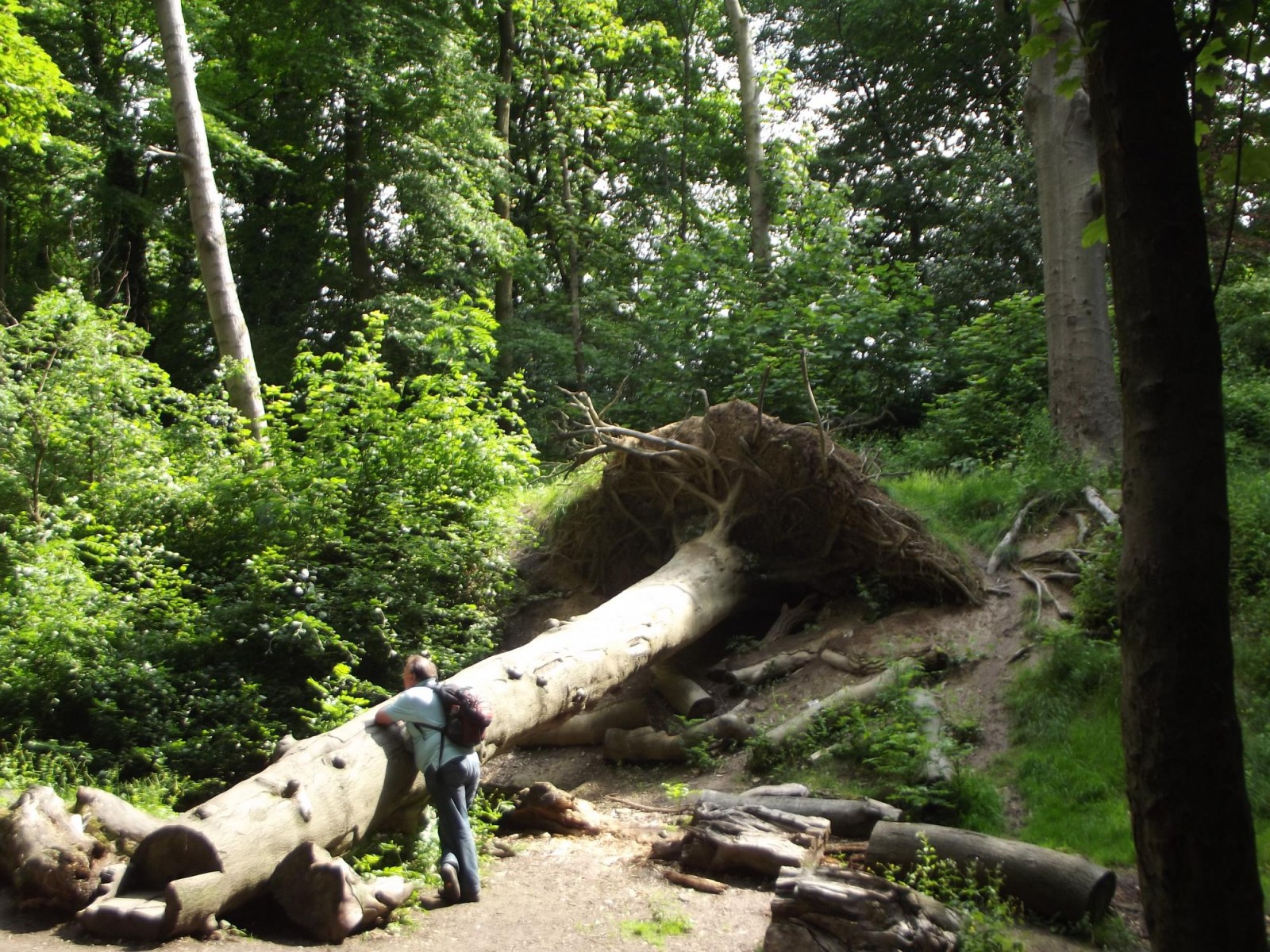
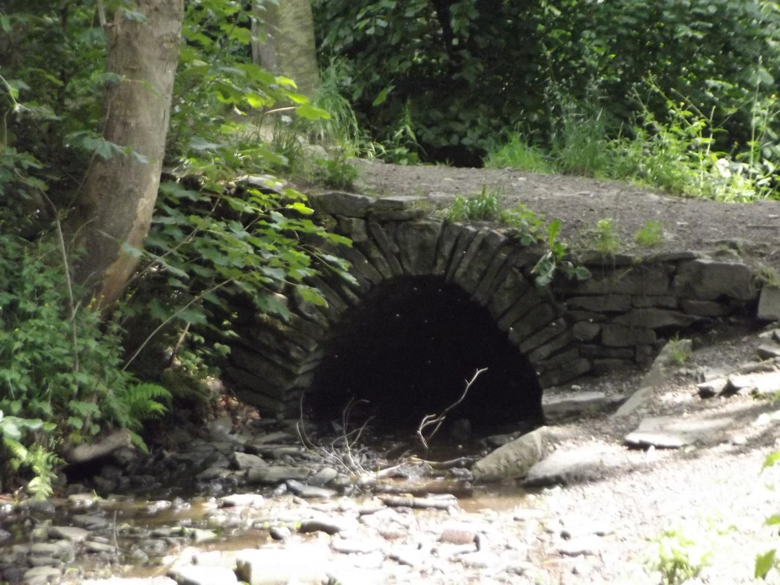
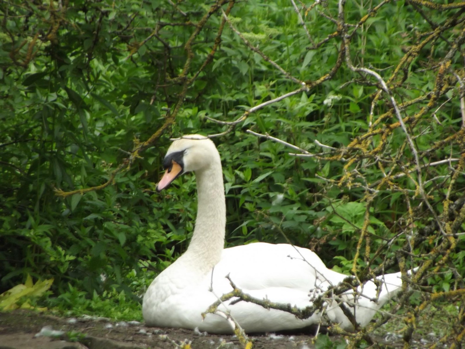
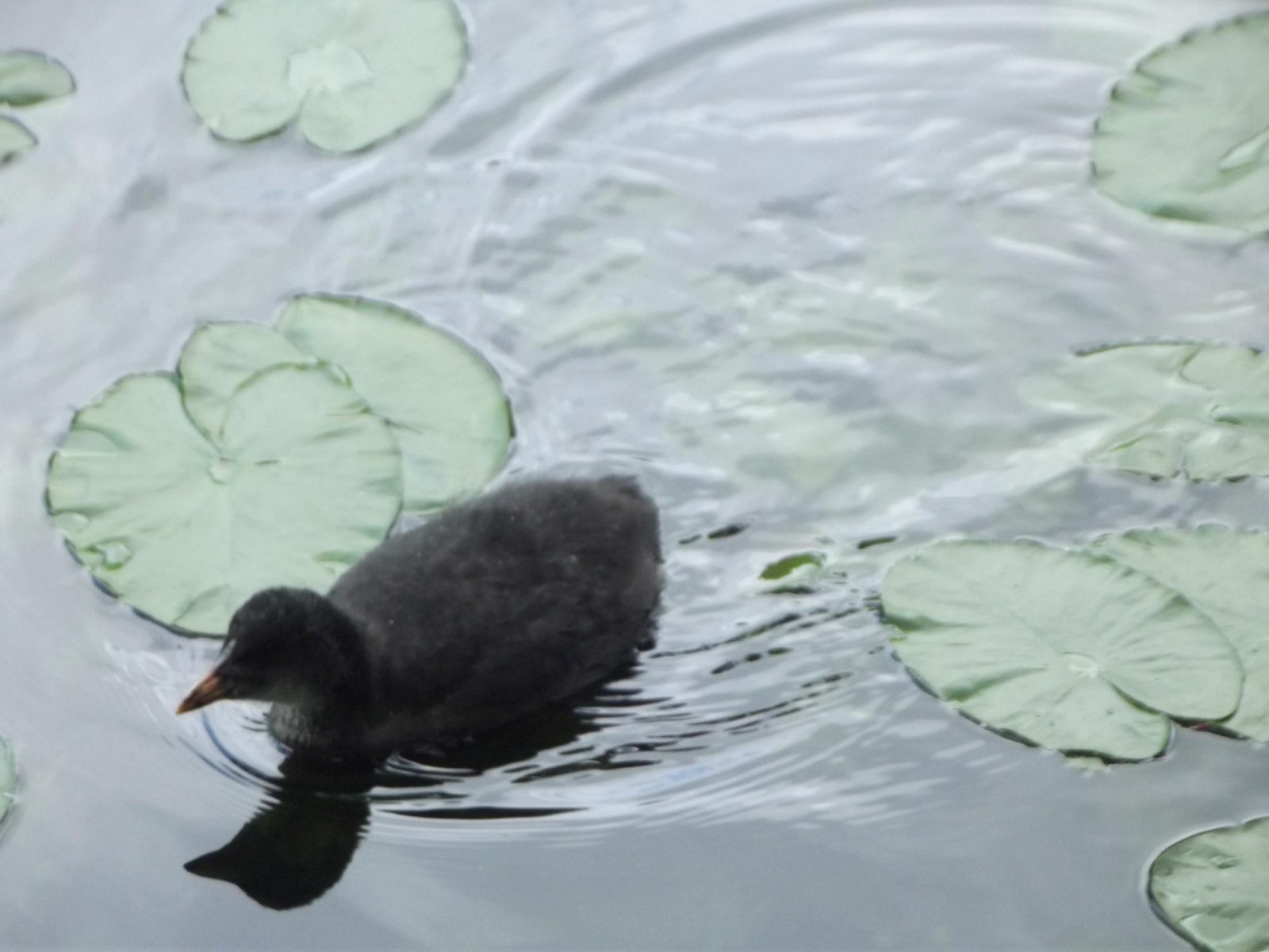
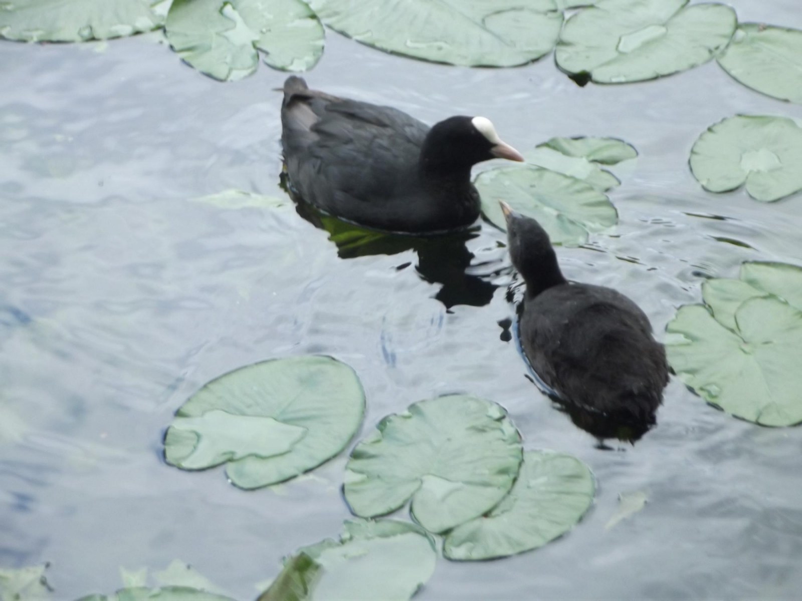
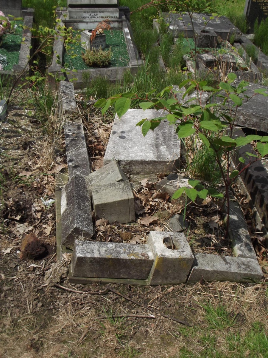
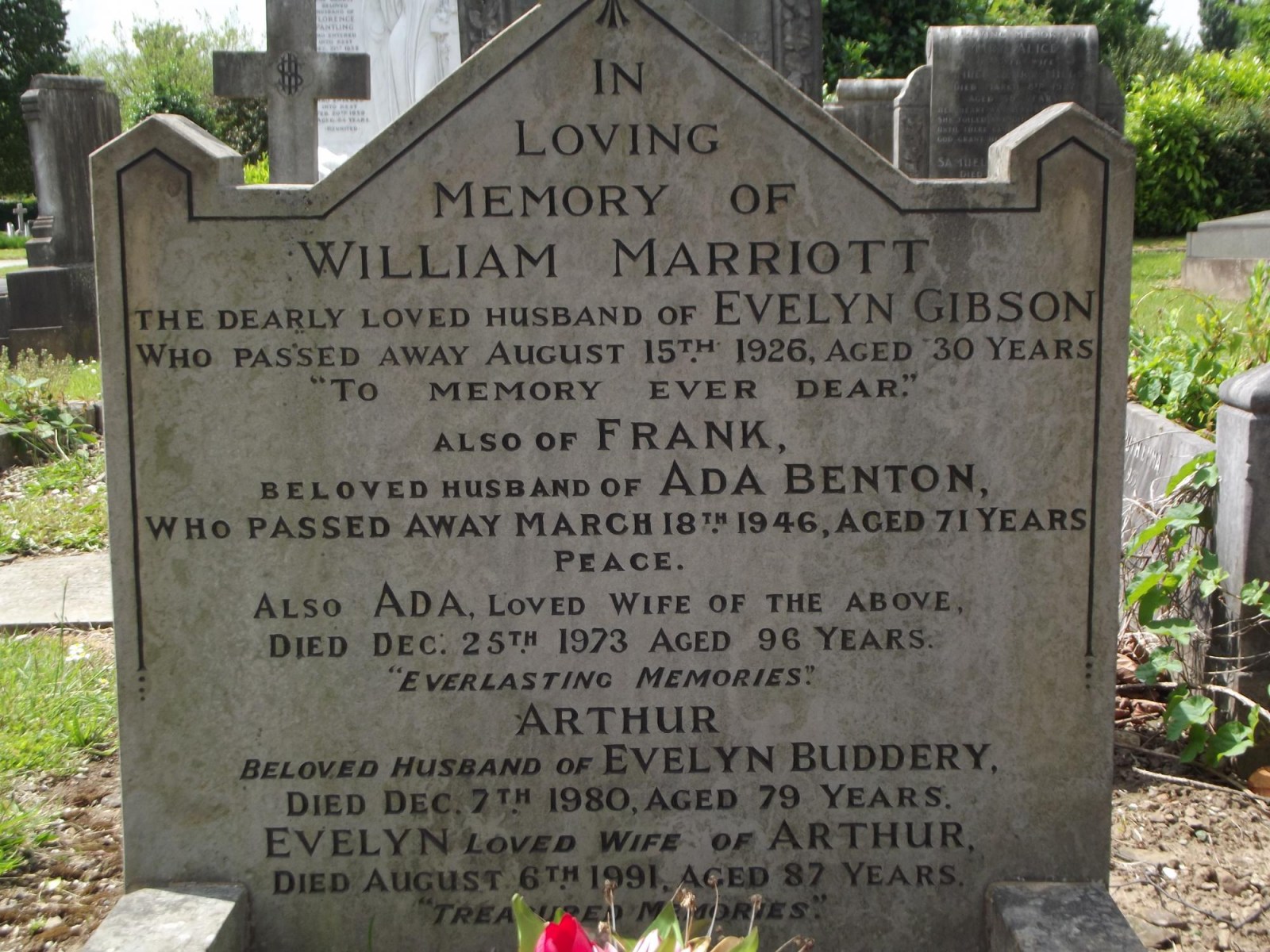
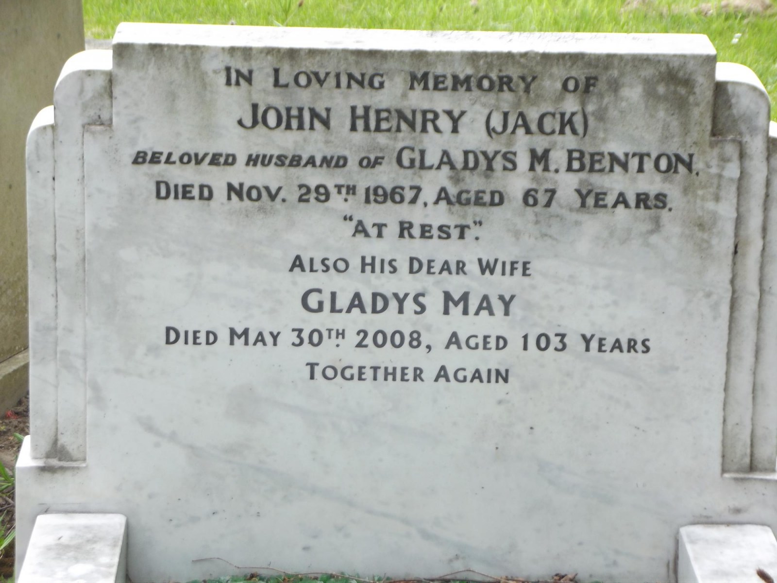
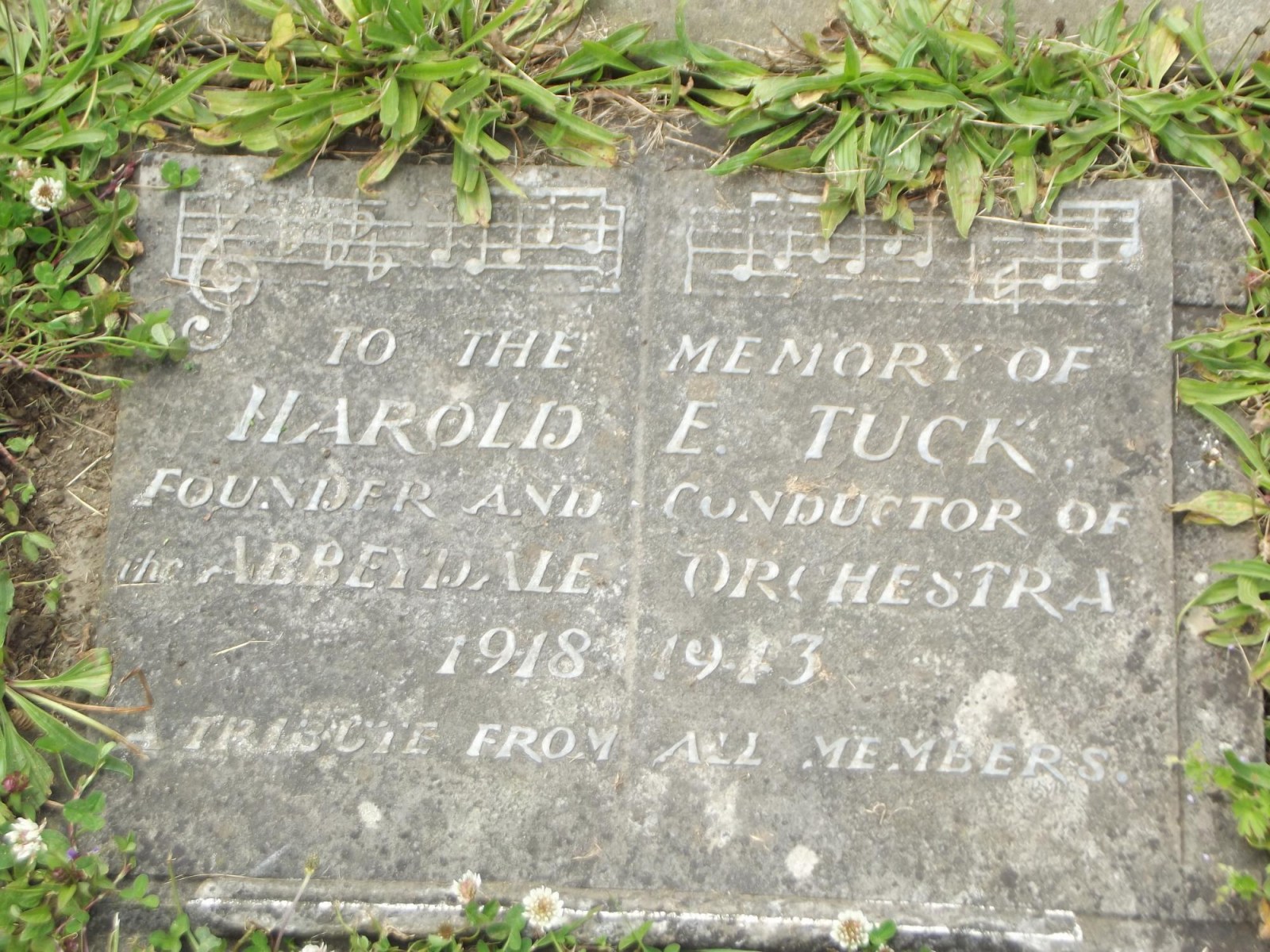
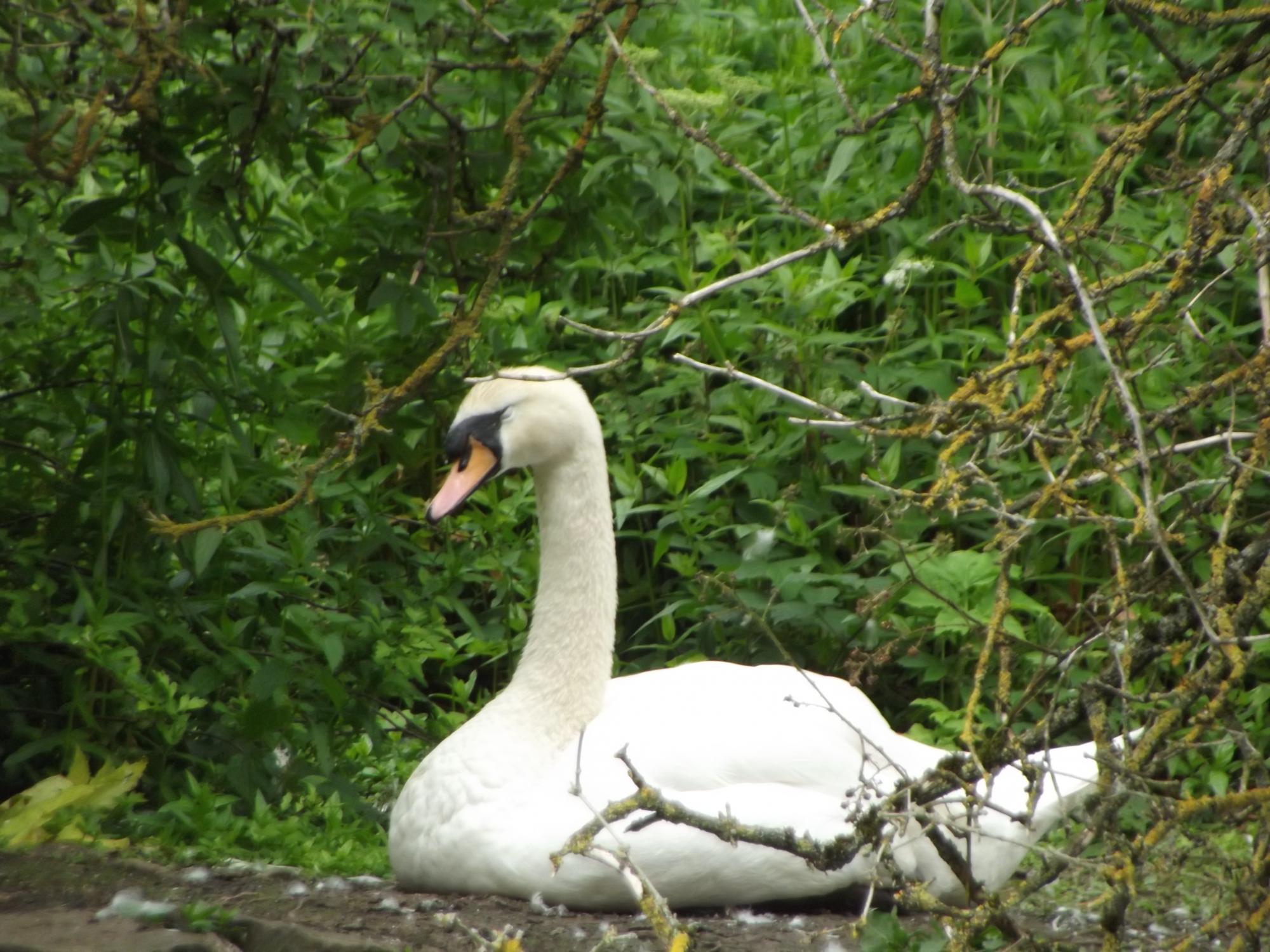
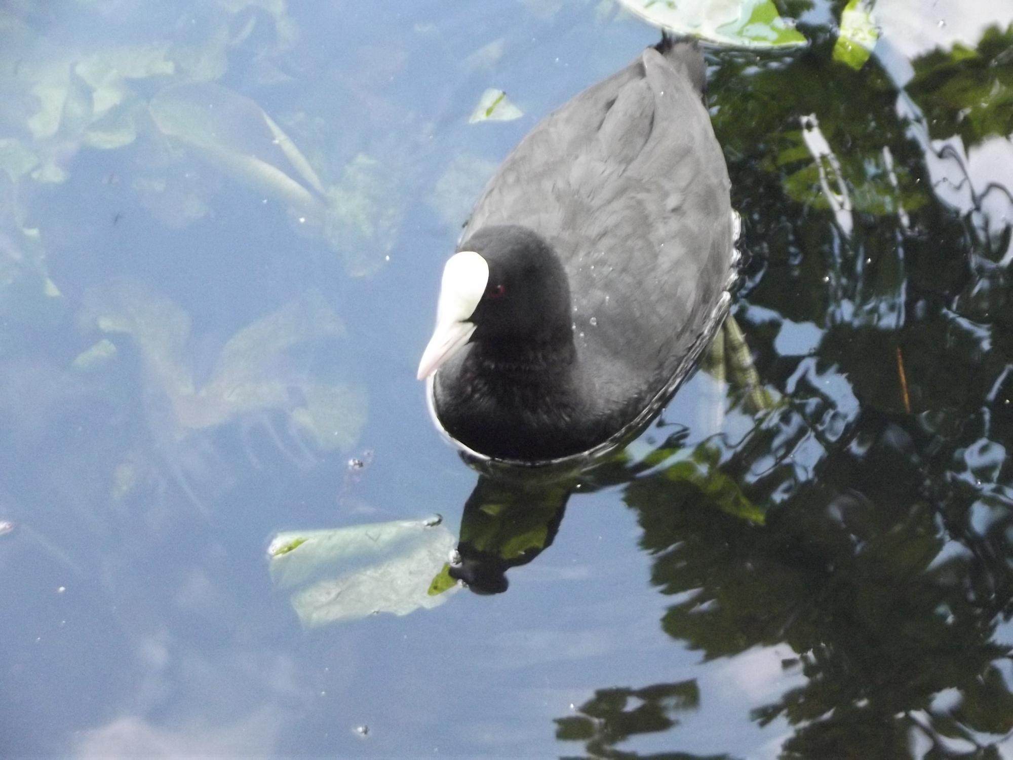
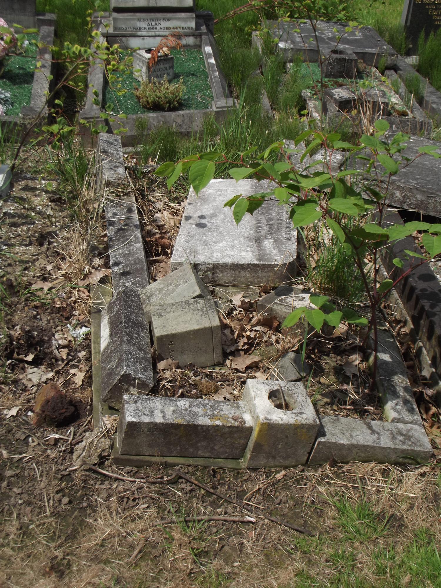
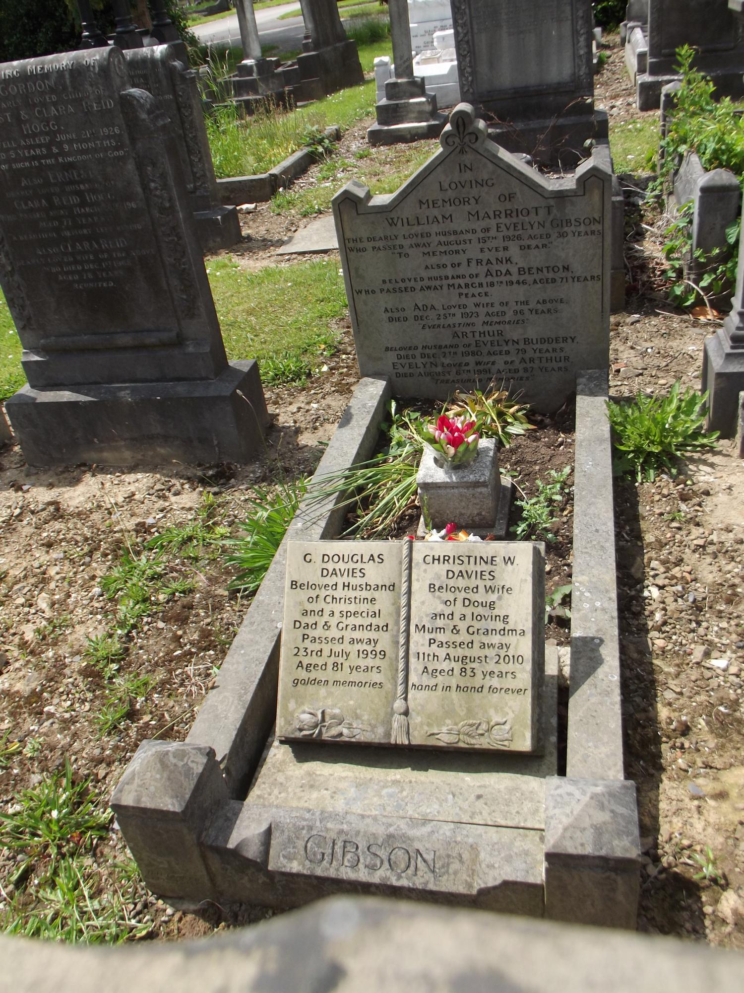
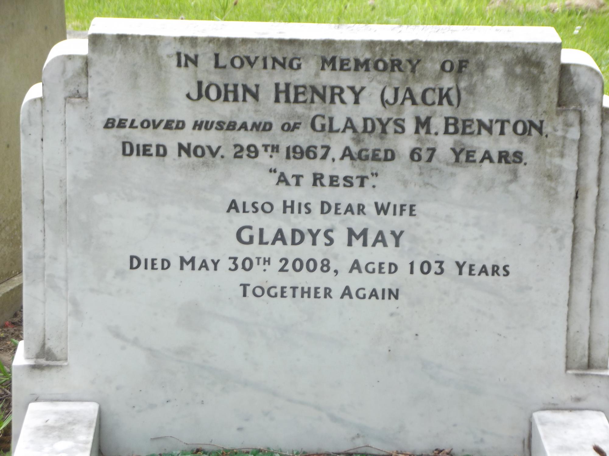
Tuesday I went searching for relatives graves at Abbey Lane Cemetery. I went via Graves Park. The first thing I noticed was a lot of dead trees in the park. Also there were workmen in the woods felling a lot of them as well as taking a lot branches off, back to the trunk. Now if this is to do with the spate of tree killing bugs that are around I don't know. Or it could be to do with general woodland maintenance, creating more light etc for new trees to grow, or a combination of the two! The first image however shows I think wind action, with some afterwards pruning. The chap isn't a woodman, but he does add scale to the picture. Not far away from this fallen tree is the Pack Horse Bridge. Meanwhile the water fowl on the ponds are enjoying the warm weather! The first picture shows a Swan on the island in the lake. While I was taking the Swan a whole bunch of them came up close. so I could get these shots including the youngsters! Ok now to Abbey Lane... As the Sheffield Indexers have the location records for the graves. I marked the ones that I was interested on a map. In section G were 3 Benton's and 1 Appleyard (my Great-Grandfather). And just my luck not one could be found! The reason is that those left have suffered damage and the vast majority in that section are suffered the worse than any other part of the cemetery. C section next to it is better in comparison, but the one Appleyard grave located in is typical of those in G section. The photo below is a good example, it is a distant cousin, of mine, the death of a young child called Sally. As the grave dates to only 1962 I was surprised at the state of it. Clearly too painful an event for my other relatives to keep visiting the grave and correct the damage. So if you have a relative in G section if the grave has survived you will be very lucky! It seems that most of the Appleyard graves (in Sheffield) of my family have been destroyed by either the Council or the elements I was a bit lucky with some of my Benton relations. Clearly the edition of more recent burials has help preserve the grave. And adds some new relations to my tree I did not know about And another grave in fantastic condition and at 103 perhaps one of the oldest people to be buried there Now to some stones that I found interesting, which I know Sheffield History Members will add lots of facts too. Sadly I spent around two hours searching G section that I didn't have time to have a full look around for more! The first came up whilst searching another section for ancestors. Some of the stones are laid flat in the grass, clearing one away I found this little musical gem! Lastly another a family grave recording the loss of a son killed in the First World War. Of course the body is still over there! It's remarkable how these older stones last much better than more recent memorials.


-

Greenhead Lane in foreground and Lound Side in background.jpg
kidneystone posted a gallery image in Sheffield History Photos
From the album: Chapeltown
-
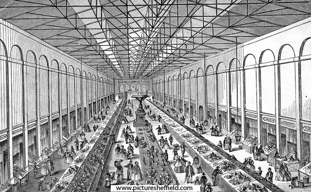
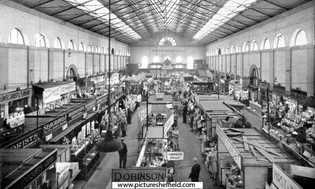
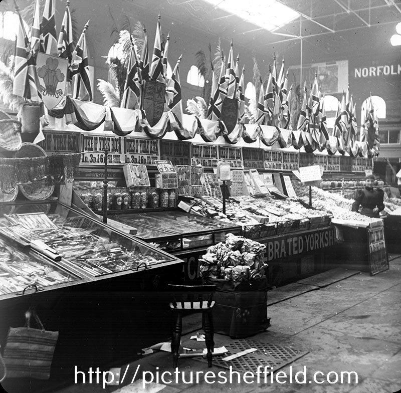
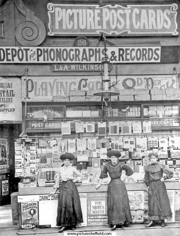
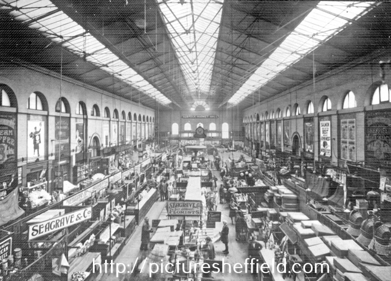
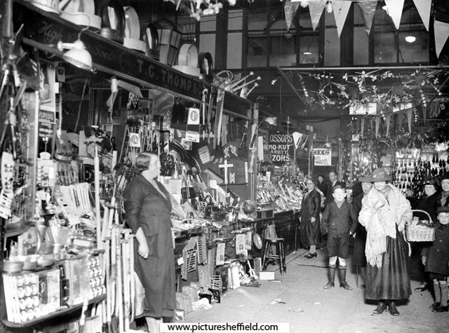
Section of New Market Hall [Norfolk Market Hall] Shows indoor fountain. M. Hirst. May 1851. https://www.picturesheffield.com/frontend.php?keywords=Ref_No_increment;EQUALS;arc04428&pos=105&action=zoom&id=151781 Interior of Norfolk Market Hall. In the centre was a fountain of Green Moor stone. The sides and ends of the market were divided into about fifty shops. Double ranges of stalls ran down the centre, so the Market was divided into four avenues. 1862. s01865 Erected by Henry Charles, 13th Duke of Norfolk, on the site of the late Tontine Inn. Opened Christmas Eve, 1851. Constructed of brick, with stone basement, quoins and dressings, in classic style. The west front was rebuilt 1904-5 with shops opening on to the Haymarket. Demolished 1959. Taken from Pawson and Brailsford's Illustrated Guide to Sheffield - 1862. Plan of Norfolk Market Hall, showing Exterior and Interior. 1847. https://www.picturesheffield.com/frontend.php?keywords=Ref_No_increment;EQUALS;arc04188&pos=15&action=zoom&id=104947 Marked: Old Haymarket, Dixon Lane, Castle Folds, Exchange Street, New Market Ground, Cheese Market, Corn Exchange, Broad Street. Sweet Stall in Norfolk Market Hall decorated (most likely) for the royal wedding of the Duke of York (future George V) 1893. w00386 Marks and Spencer, small wares dealers, Norfolk Market Hall. The Green Moor stone fountain can be seen in the background. 1901. https://www.picturesheffield.com/frontend.php?keywords=Ref_No_increment;EQUALS;s00296&pos=39&action=zoom&id=4284 Marks and Spencer, small wares dealers,1901. https://www.picturesheffield.com/frontend.php?keywords=Ref_No_increment;EQUALS;s01871&pos=40&action=zoom&id=5689 L. and A. Wilkinson, stationers, No. 26 Norfolk Market Hall, possibly the first stall to sell records. 1902. s00294 Interior of Norfolk Market Hall s00294 Mrs Thompson outside her shop, Miss Bush and Thomas Albert Glossop in background. Possibly 1935 Shopping Festival. v03852 Photographer: Sheffield Daily Independent. Florists Stall. t08967 Interior of Norfolk Market Hall. y02727 Norfolk Market opened Christmas Eve 1851 for sale by retail of miscellaneous goods, flowers and a small quantity of food. For more information see: City of Sheffield, Municipal Markets, a brief description with Historical Notes relating thereto Jubilee Edition 1949 Ref: MP 4065 M For more photographs of Norfolk Market Hall see: https://picturesheffield.com
-

The blue 'police box' next to the town hall
Ponytail replied to Sheffield History's topic in Sheffield History Chat
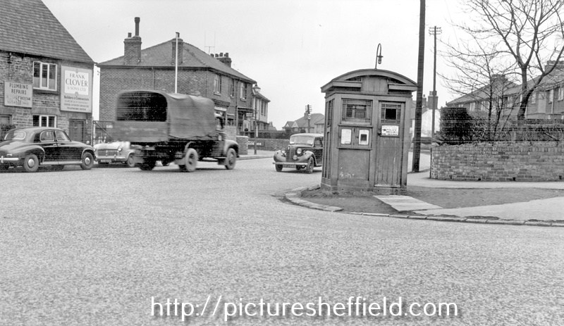
Meadowhead looking towards junction with Greenhill Main Road, Police Box right. 26th August 1966.s17884 Photographer: City Engineers Department. Norton Lees Lane, at junction with Derbyshire Lane, prior to removal of Police Box and (left) Nos. 9-11, Frank Clover and Sons Ltd., builders. 25th March 1954.s18416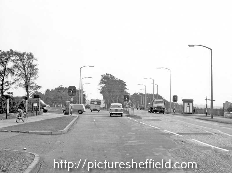
-
The blue 'police box' next to the town hall
Ponytail replied to Sheffield History's topic in Sheffield History Chat
Police Box near the junction of Norwood Avenue and Herries Road showing the junction with Longley Lane. 10th November 1960.s17156 Photographer: City Engineers Department. Police Box, Hatfield House Lane at the junction with Barnsley Road. 20th July 1955.s17161 Photographer: City Engineers Department. Police Box, Firth Park Roundabout, January 1949. https://www.picturesheffield.com/frontend.php?keywords=Ref_No_increment;EQUALS;s15827&pos=39&action=zoom&id=18660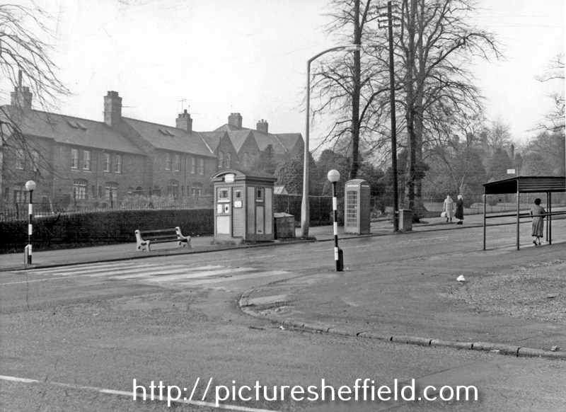
-

Unidentified Public Houses and Refreshment Rooms
Edmund replied to Ponytail's topic in Sheffield History Chat
Welcome Samuel Gillatt, son of George (scissor forger) and Caroline, was born on 27th August 1867. His main career was as a file cutter, but he may have started catching rats to be worried by dogs. By 1901 Welcome and his wife Ada were at 165 Woodside Lane with 5 children, one of whom was Welcome junior aged 4. His first newspaper advert appears to be in the Mexborough & Swinton Times of 3rd December 1897: WELCOME GILLAT. Ratcatcher, open for engagements. Dealer in Ferrets. Ferrets lent on hire, ratting or rabitting. :- 25 Court, 2 house, Woodside Lane, Sheffield. In December 1901 as well as his ratcatching services, he advertised "Ship rats for sale" - an unusual Christmas present, or for worrying by dogs? In February 1919 Welcome was appointed "Official Ratcatcher to the City". This was the first time such an officer had been needed, but was due to the plague of rats which had grown during the war, mainly due to the increase in land under cultivation. Then as the winter weather arrived, they migrated to built up areas. Welcome had been catching rats for forty years, catching them alive with ferrets and a wire cage. Applications for his services had to be made through the Cleansing Department Superintendent. In March he caught 1,050 rats in four weeks, beating all previous records. Yorkshire County Council were granting 2d per rat killed to Sheffield City Council. In October 1919, Welcome had a great success in catching a wily old rat that frequented the Cathedral neighbourhood. This rat was fancied to be 'a grand old man' with a long grey beard and a splendid voice despite his years. Supposedly the rat danced on the Cathedral tombstones, and was a politician, addressing mass meetings of his tribe in Paradise Square each night. Welcome set out to 'bag him' and after a successful and exciting hunt declared "Yes, he's a beauty - he weighs just over a pound and will be one of the biggest we have in England". Welcome was so successful in his work that a bag of 40 rats a day was now considered a good one. In the "good old days" a bag of 375 in a day was possible. In August 1922 Welcome caught an outstanding specimen weighing 1 lb 5 oz at Mr Simmerson's house, 100 Nottingham Street. Mr Gillatt had netted the entrance to several holes when the rat was discovered in a fowlhouse. It jumped one of the nets and as it was making its escape Welcome grabbed it and captured it alive. He took it to the Telegraph offices to show it off, whereupon it attempted to snap at its captor. Welcome intended to have it stuffed, as "the finest specimen I have ever captured". He estimated that over his career he had killed tens of thousands in Sheffield alone, plus those in outlying districts. In 1927 he tamed and trained a fox, with the intention of using it to catch rats. In 1939, still the Corporation rat-catcher, he was living with Ada at Firshill Terrace. Welcome died in 1940. Welcome junior joined the Royal Navy in June 1915 as an armourer and was discharged in November 1921. He married Elsie McKay, also of Woodside Lane, in November 1919 and they had two girls, Edna and Joyce. Welcome junior died, a 33 year old bus conductor, at Lodge Moor Hospital in February 1930. Welcome senior's son Ernest, a fireman, married Frances Brayshaw in September 1927 and they named their son (born early in 1931) as Welcome. Welcome died in Sheffield in Oct/Nov/Dec 1996, and his wife Lilian Anita in 2018. Presumably this chap was the licensee on the photo of the unidentified licensed premises. -

Newhall Road, Newhall Wire Mills
SteveHB replied to Aaron James Hartley's topic in Sheffield History Chat
The illustrated guide to Sheffield and the surrounding district. 1879. "Messrs. John Hartley and Co., Newhall Wire Mills, manufac- ture wire for pit and other ropes, umbrellas, and various other pur- poses. On the next page we give an illustration of their works, which have been carefully arranged with a view to the requirements of the business, and are fitted with modern machinery and appliances." link https://archive.org/details/illustratedguide00tayl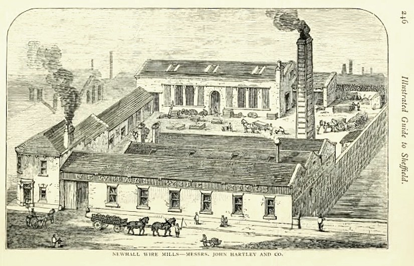
-
Hatfield House Lane Class J3 1962 Where are you?
Fairthornroader posted a topic in Sheffield History Chat
Retirement brings on many extramural activities and having nearly completed my bucket list before the next bucket I see is the one I kick, I thought it prudent to see who's left out of my old class and where and WHO they are now ( many of the girls will obviously have a change of name ).. See link below http://www.picturesheffield.com/frontend.php?action=printdetails&keywords=Ref_No_increment;EQUALS;m00003 A few of our motley crew, I have sincerely missed since I left and I curiously would like to see how we all did after Smiley's J4 class and the ensuing 11+ dispersal. -
I had a nosey along the current Jew Lane the other day, walked past it loads of times but never along it. Im wondering if it used to be more of a thoroughfare than it is now? Anyone know anything of its history? From other threads there was a Jehu Lane which was where Fitzalan Sq is now, which currently contains all the bookmakers. Im referring to the current Jew Lane that has an entrance on Fitzalan Sq that runs between what is now the Coral bookmakers and the building that used to be the Blue Bel pub, and an entrance on Commercial St.. Heres a view from Commercial St.. From Fitzalan Sq, Looking down Jew Lane from Fitzalan Sq.. Looking back up Jew Lane towards Fitzalan Sq.. Having walked down Jew Lane from Commercial St, here it turns 90 degs right up to Fitzalan Sq. I wonder what this white brick building used to be?..
-
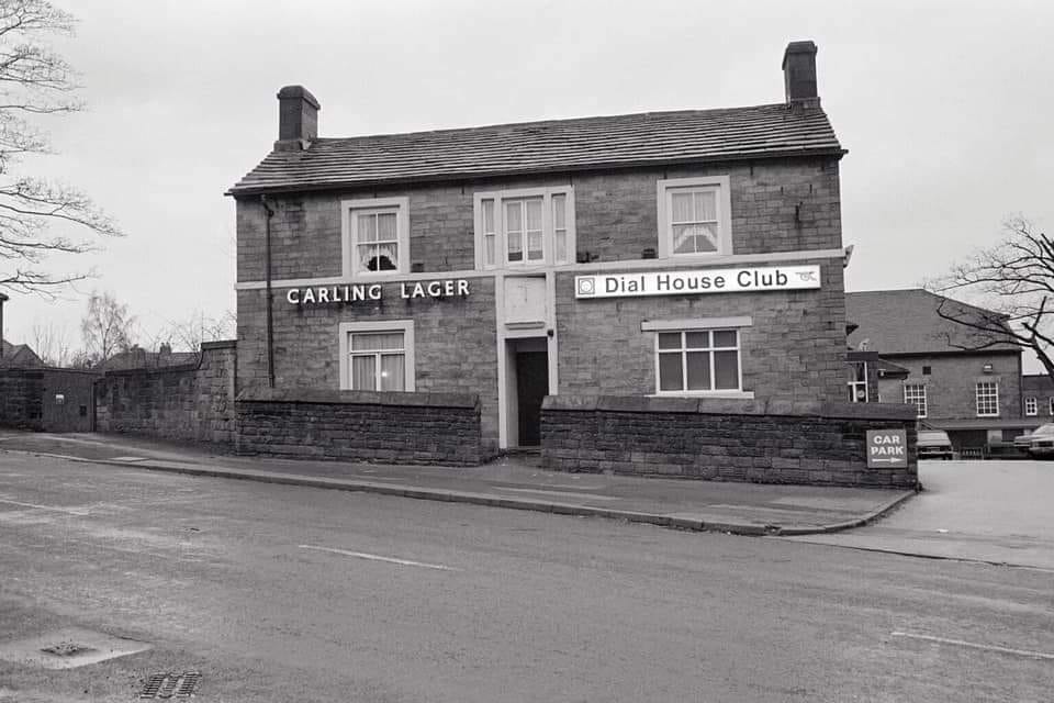
THE DIAL HOUSE CLUB LOCATION Ben Lane, Sheffield 6
-
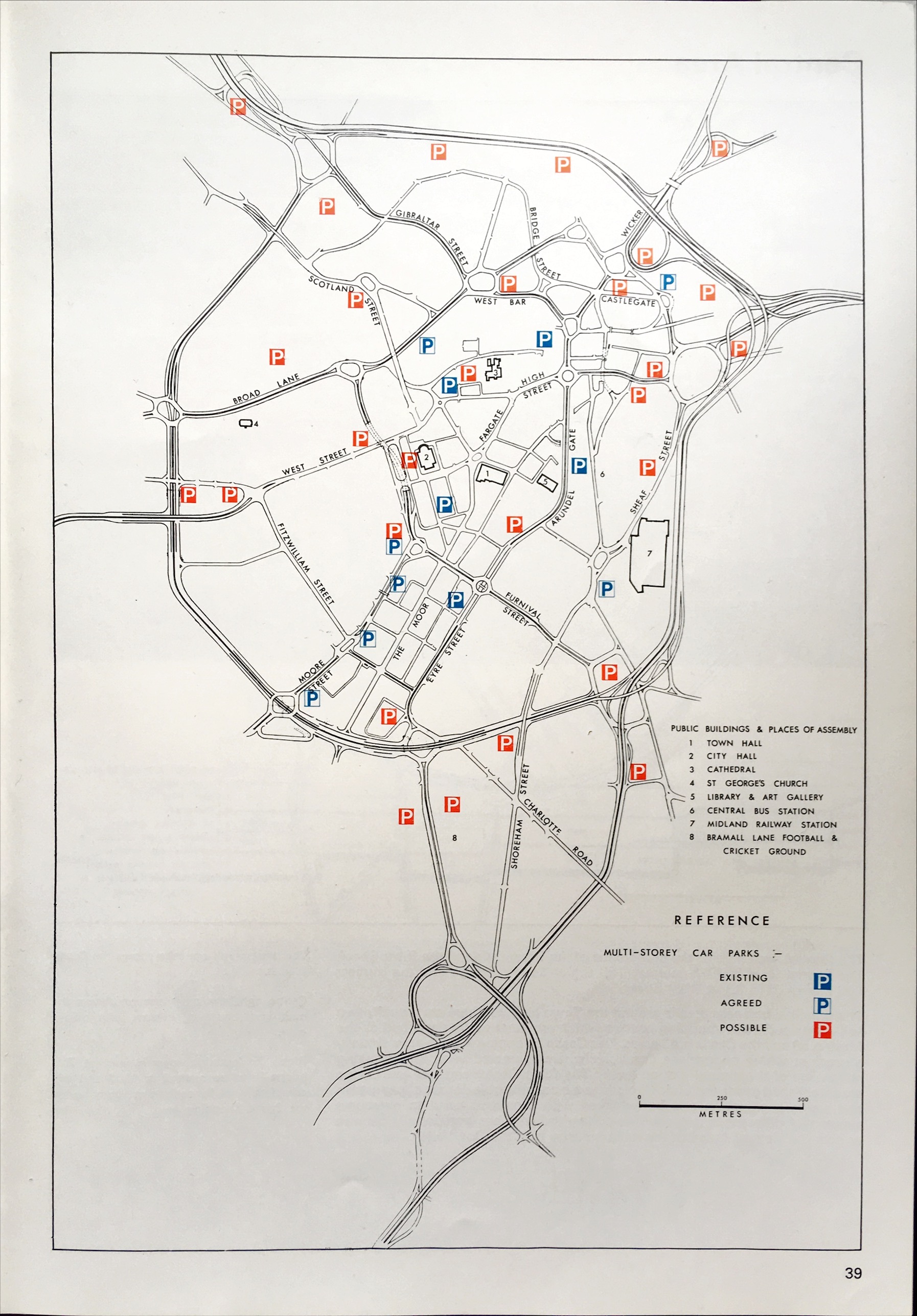
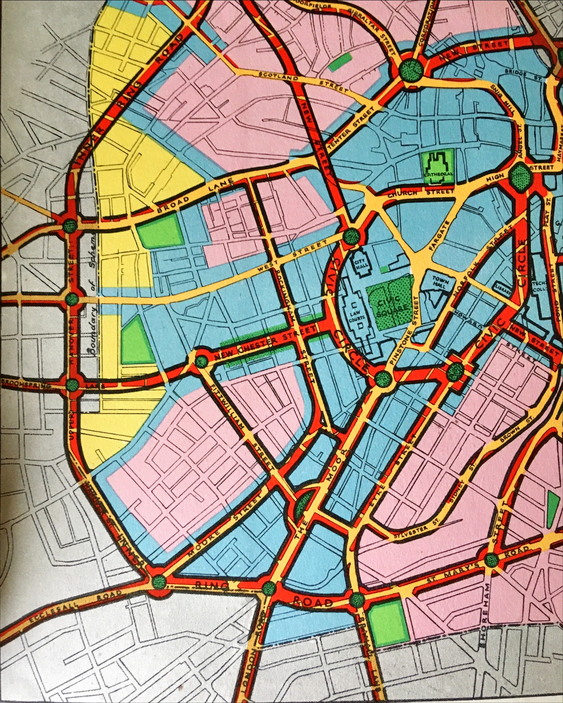
Old Plans (40's/60's) to relocated West Street via Broomspring Lane
Sheff-lad posted a topic in Sheffield History Chat
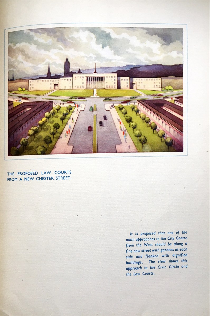
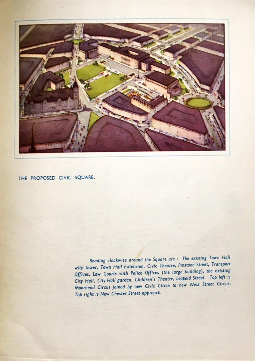
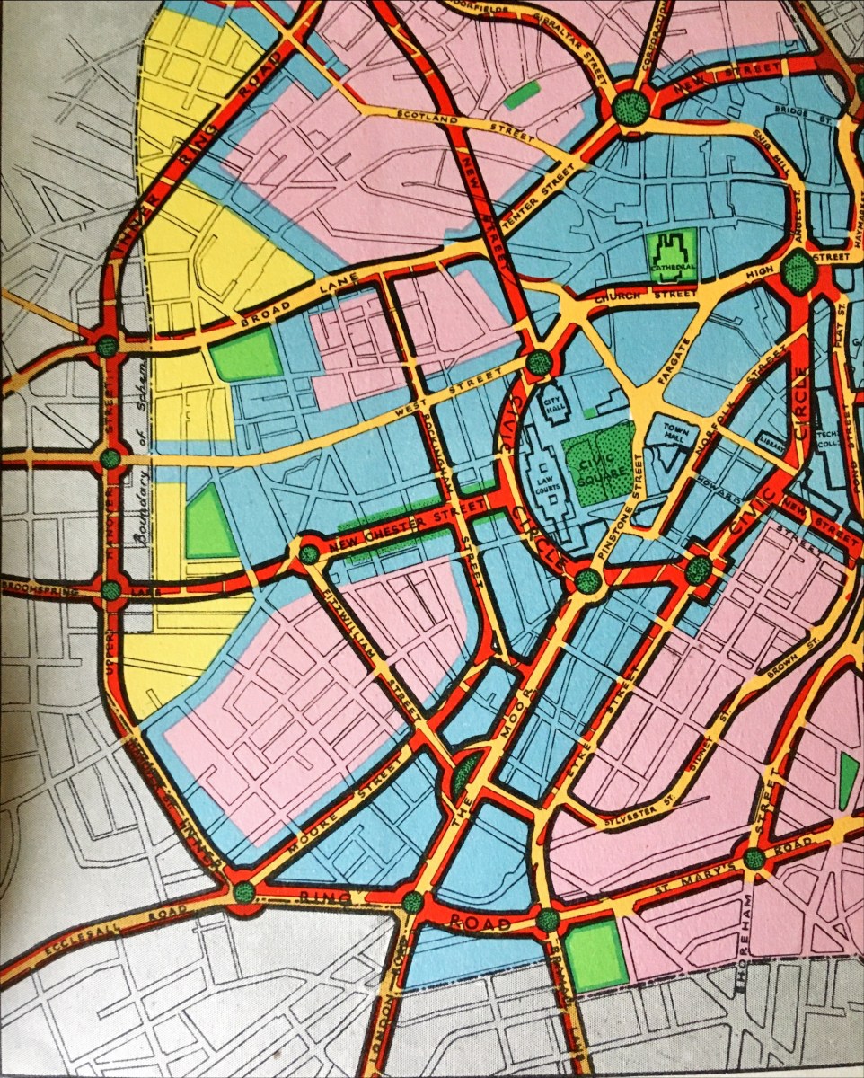
I recently bought 'Sheffield: Emerging City (1969)' on how post-war rebuilding was going and what they planned to do for the future, which other than being a brilliant book, revealed old plans as they were in mid-flow. I was reading it and found in their overall plans that there was a side-plan to relocate West Street at the junction with Fitzwilliam Street via Broomspring lane, creating a new junction on the ring road where Hanover Street becomes Upper Hanover street. I wondered if anyone knew anything more about where this road would go or if anyone had any more details of the plan or whether it was just a brief side-note on the diagram. It also shows that (as originally planned in 'Sheffield Replanned (1945)') there would be another street or entrance way to the city along Wellingon Street which again is nowhere to be found. Photos attached, any information would be greatly appreciated. - I wonder if it would join Glossop road near the Hallamshire and be a dual carriageway along Manchester Road. The overall plan in two parts for the A61(M.) The area in question With the routes highlighted The diagram from 'Sheffield: Emerging City (1969)' The new street along Wellington Street as seen in 'Sheffield Replanned (1945)' And again from another angle And here as part of the overall development map.thumb.jpg.febacffcdb3cb364d1f05d792679250c.jpg)
-Copy.jpg.47e31c3ac3e801a8cc54d4666f9b98cf.jpg)
-RoutesShown.thumb.jpg.5370a934b8866808f38b11c5175942ca.jpg)
-

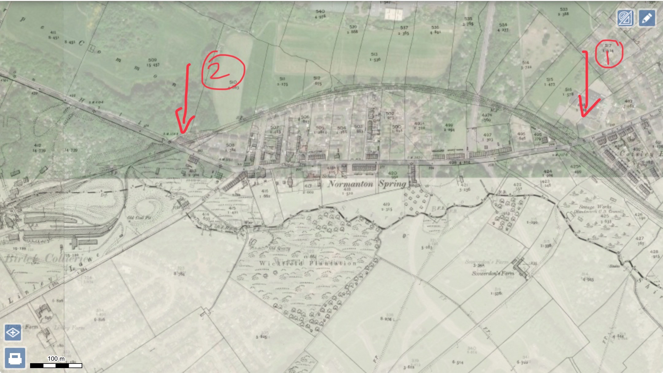
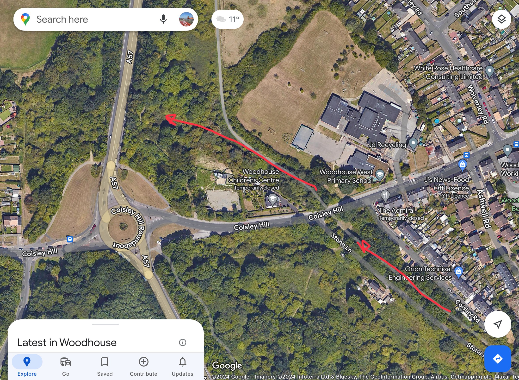
Birley Collieries Branch Line
History dude replied to Paolo Coopio's topic in Sheffield Buses, Trams and Trains
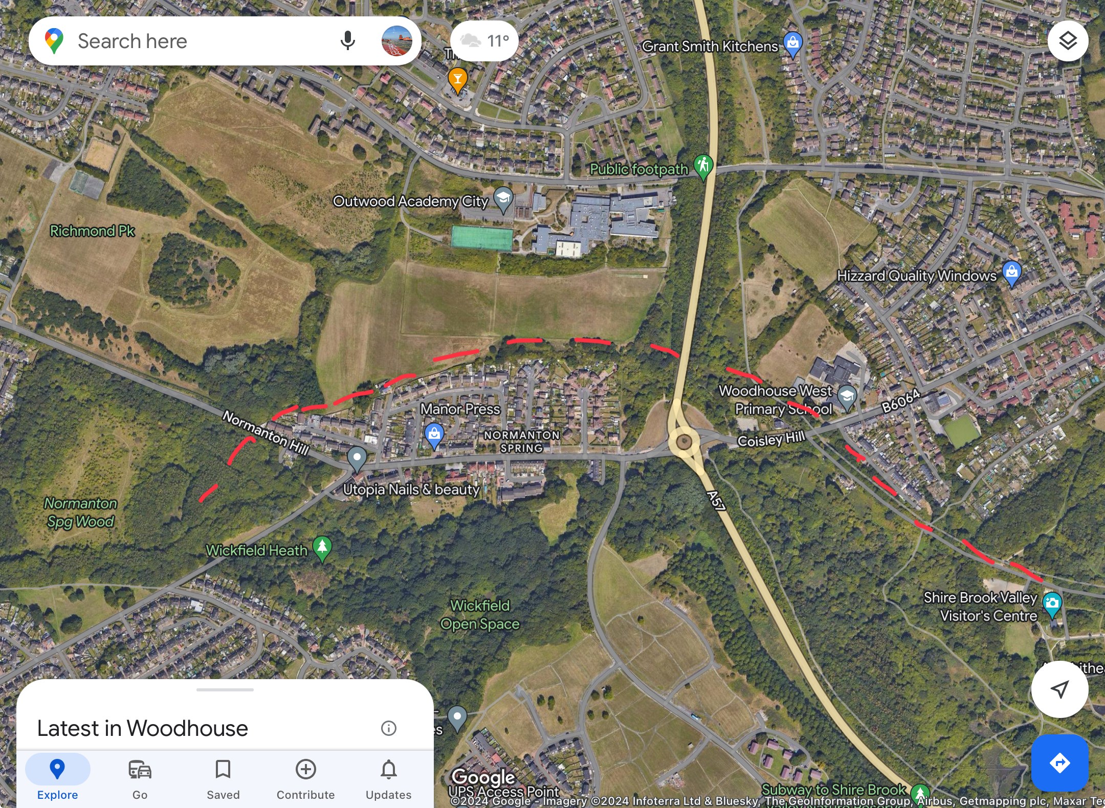
If you look at R Longden's map and at Fields 504 and 505 at the top end, you can see that the cutting cuts away and indicates a bridge over lane/path. If you look in the background of my photo, you can see the school building of City School, which ties in nicely with the modern academy on the modern satellite image and following it down the large green blob of trees might indicate that the bridge is still there. So the "tunnel" is not a tunnel, but a bridge with the railway line on top and the path below it. I have had a look around Google Street View, and modern buildings now block the original view I took in the 1980s. However, there is a footpath at the back which can be accessed via Haxby Street and the cul-de-sac off it. Near where the large building that crosses over the boundary line of the estate.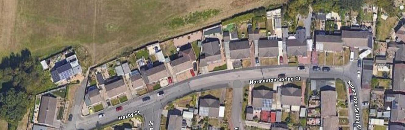
-
Birley Collieries Branch Line
Lemmy117 replied to Paolo Coopio's topic in Sheffield Buses, Trams and Trains
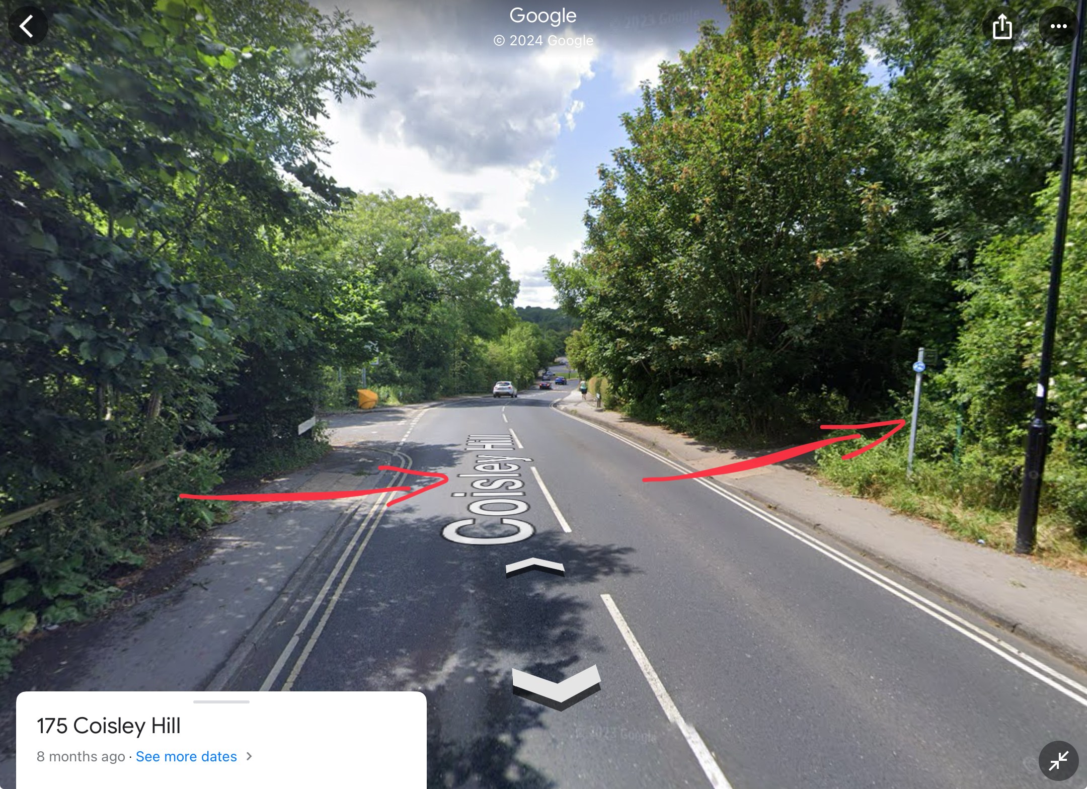
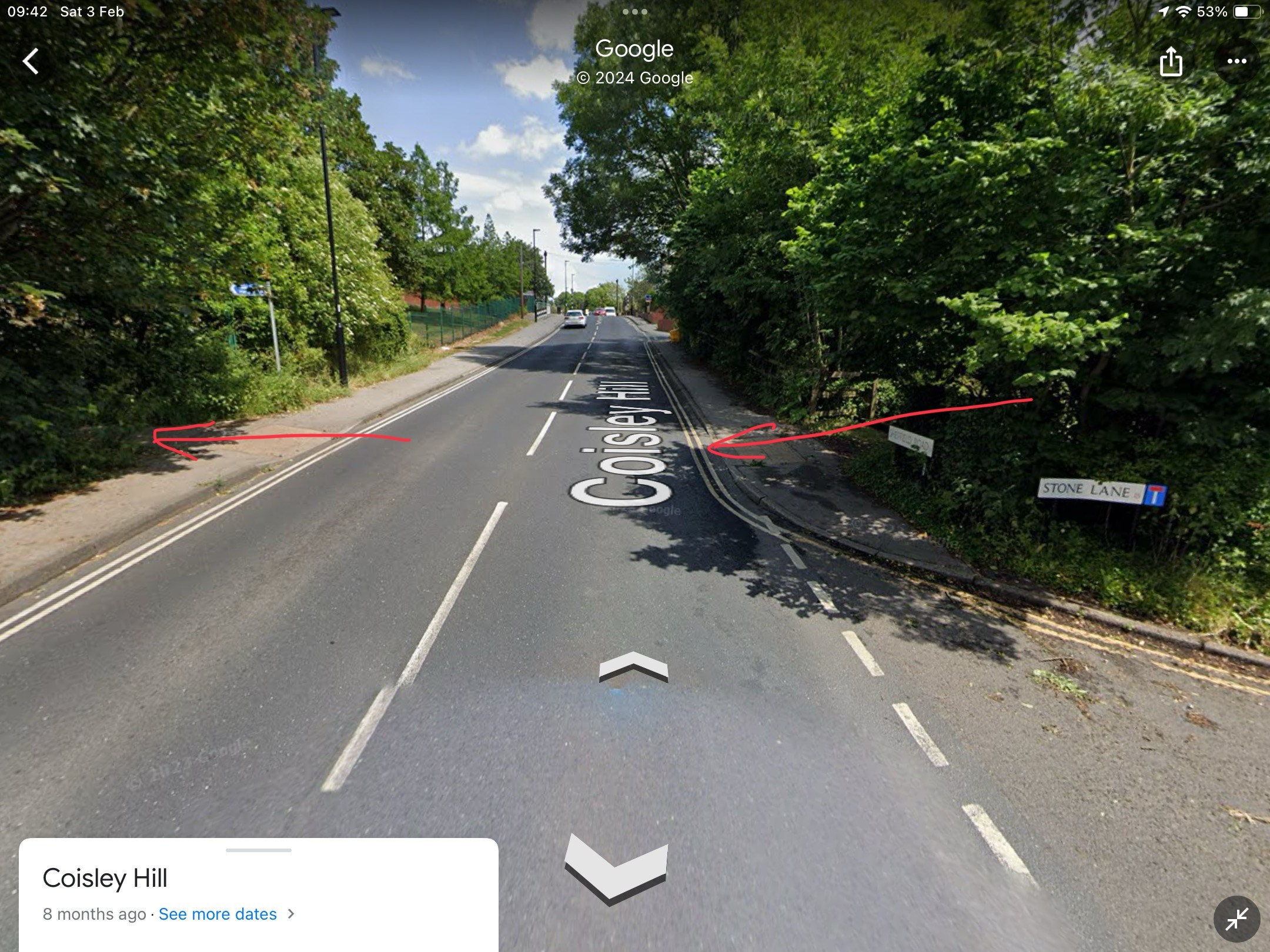
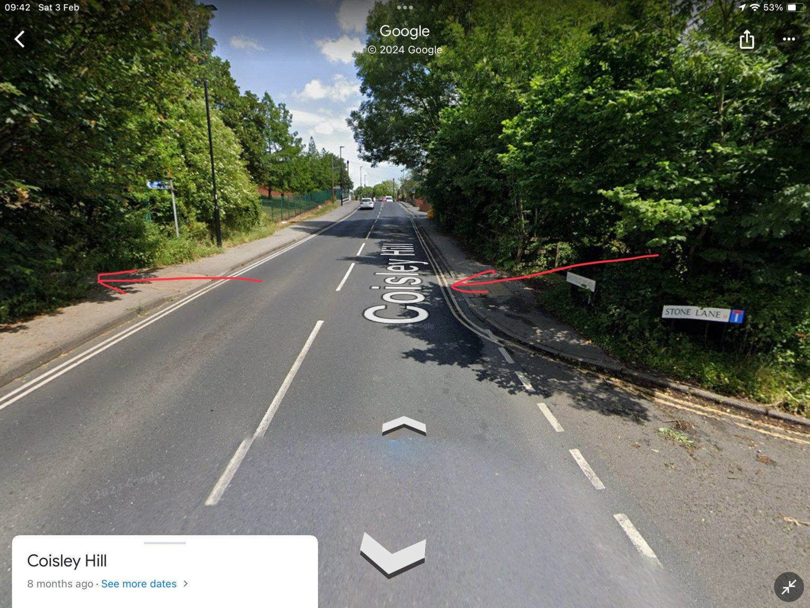
Thanks to that map it seems there was a bridge on Coisley Hill which I was not aware of. From the current pictures it seems the cutting has been filled in next to Stone Lane to bring the path up to road level. That's the good thing about this site, you learn something new every day! -

Birley Collieries Branch Line
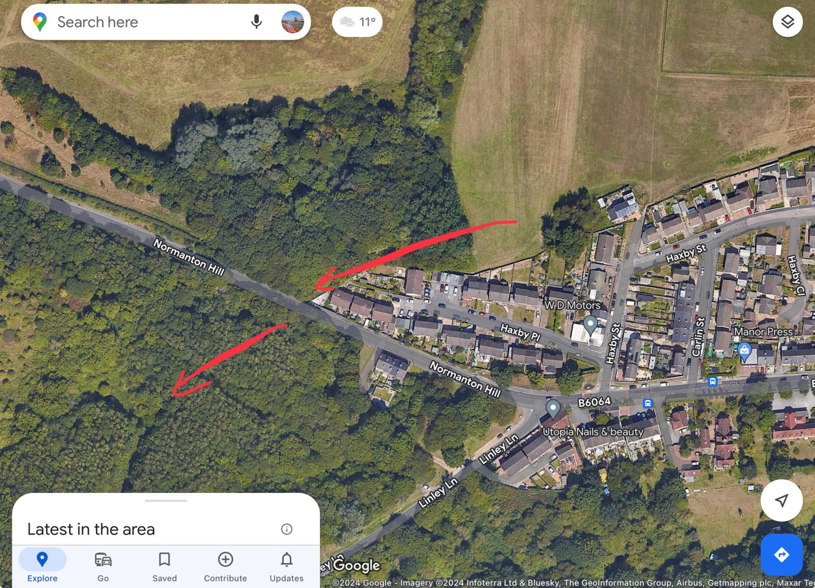
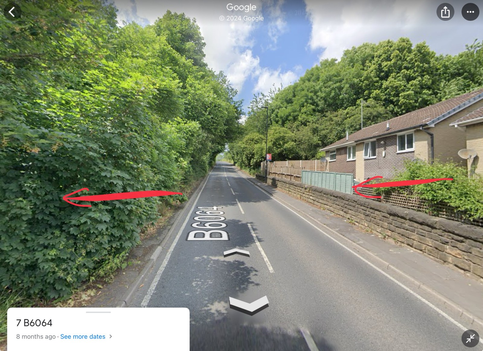
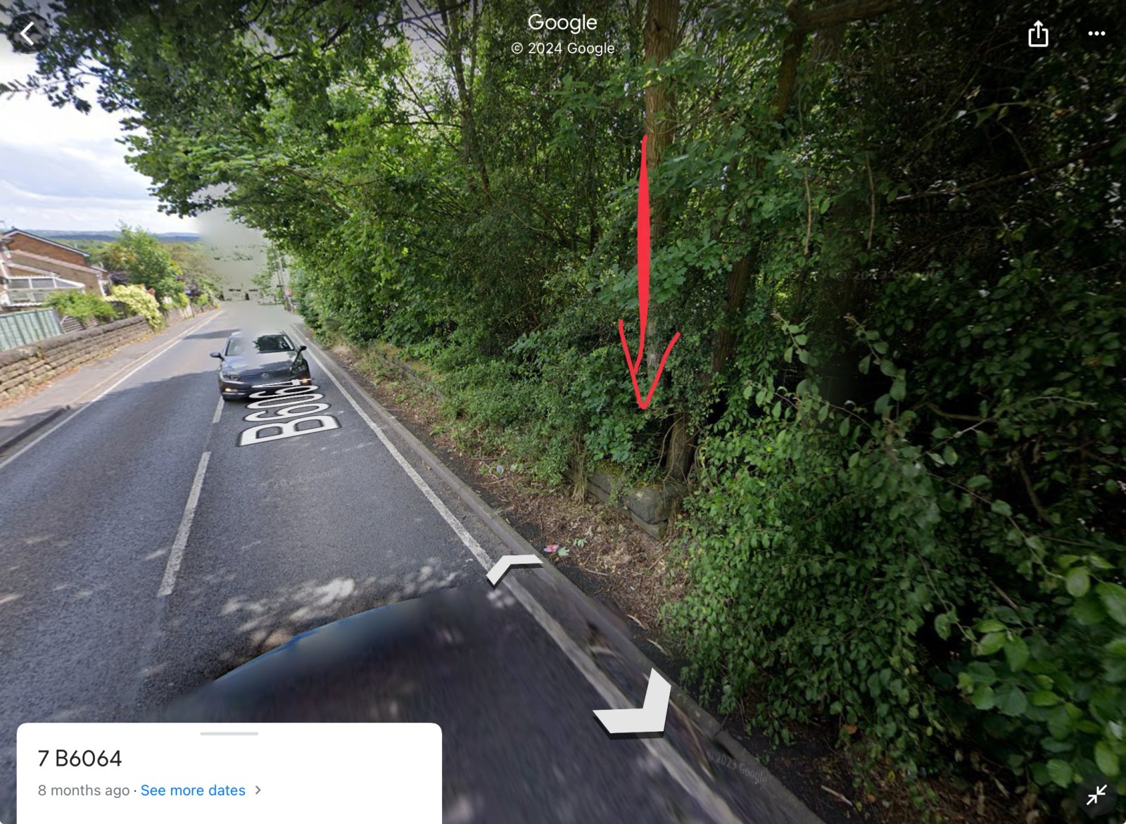
RLongden replied to Paolo Coopio's topic in Sheffield Buses, Trams and Trains
The line cut the road at 2 points. 1) Coisley Hill and 2) Normanton Hill. 1) You can see where the track bed was, as it’s now a part of the Trans Pennine Trail. It crosses Coisley Hill just up from Stone Lane, where the kerbs have been dropped either side 2) Just above the end house on the right going uphill, you can see the wall either side and the ‘drop’, where the tunnel cut under the road. Assume the level of the ground was backfilled to accommodate the houses, though if you peer over the wall/fence, it is still well below road level The trace of the line can still be seen in the vegetation, wall and property boundaries Hope this helps to visualise the route and crossing points?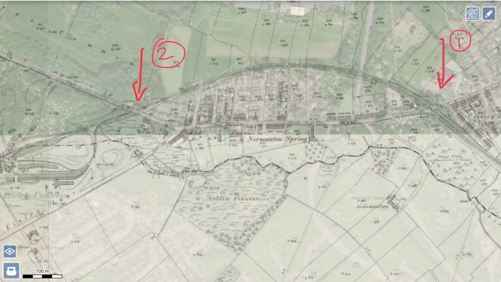


-
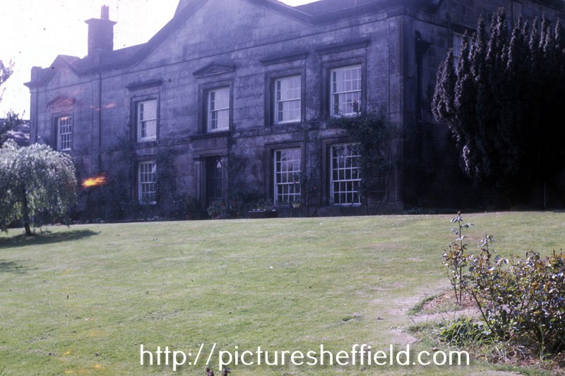
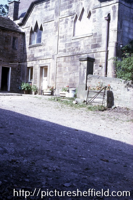
Revell Grange, Bingley Lane. August 1991.Picture Sheffield No s27895 Front Elevation. Picture Sheffield No. s27893 Revell Grange, seat of the Revell family who moved there from Nethergate Hall in 1742, they were Roman Catholics, and the private chapel was in continuous use as a Mass centre until 1828, mission reopened 1855's. See The Lord's House, a history of Sheffield's Roman Catholic Buildings 1570-1990 , Denis Evinson Ref: 282.4274 S. also Transactions of the Hunter Archaeological Society Vol 9 1964-69 page 196 S https://www.picturesheffield.com/frontend.php?keywords=Ref_No_increment;EQUALS;s27896&pos=4&action=zoom&id=30630 Rear elevation and Chapel, Revell Grange, Bingley Lane. s27894 https://www.picturesheffield.com/frontend.php?keywords=Ref_No_increment;EQUALS;s27897&pos=5&action=zoom&id=30631 Stables, Revell Grange. https://www.picturesheffield.com/frontend.php?keywords=Ref_No_increment;EQUALS;s27898&pos=6&action=zoom&id=30632 https://www.picturesheffield.com/frontend.php?keywords=Ref_No_increment;EQUALS;s27899&pos=7&action=zoom&id=30633 Revell Grange, Bingley Lane, Stannington front elevation. July 1974. w01504 From the West End. w01503 Photographer: David Cathels Revell Grange Grade II Listed Building. 8th August 1985. https://historicengland.org.uk/listing/the-list/list-entry/1132865 https://en.m.wikipedia.org/wiki/Revell_Grange https://cityseeker.com/sheffield/878723-revell-grange


-
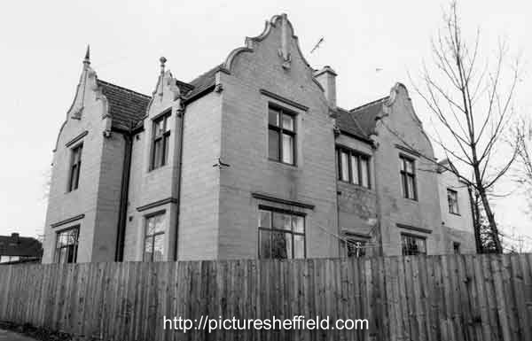
Norwood Grange, junction of Longley Lane, Herries Road and Norwood Grange Drive. 15th March 1983 s38698 December 1988.s38697 December 1988s38696 Norwood Grange now a Care Home. https://www.norwoodgrange.co.uk/
-
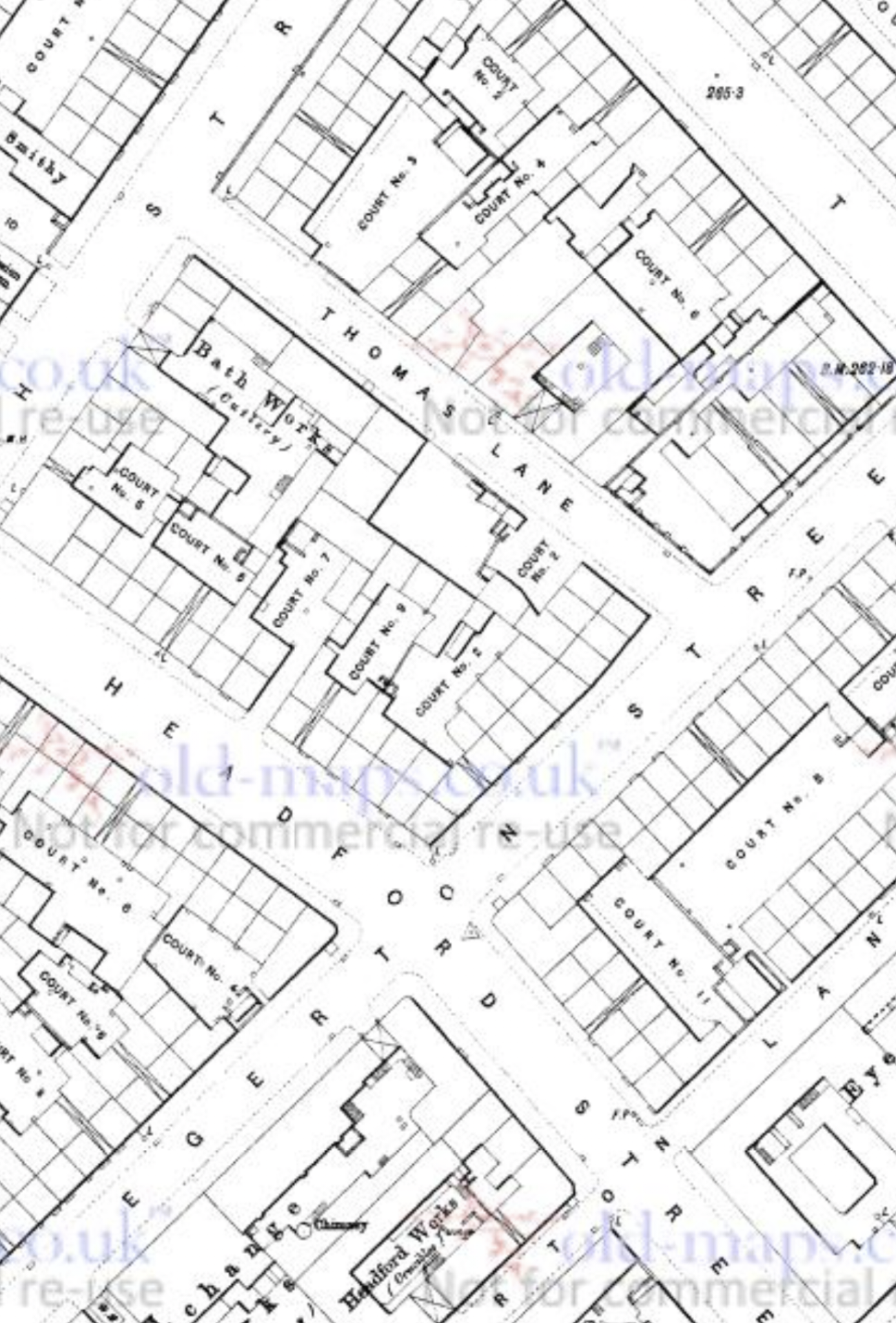
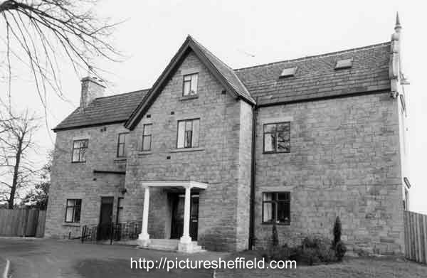
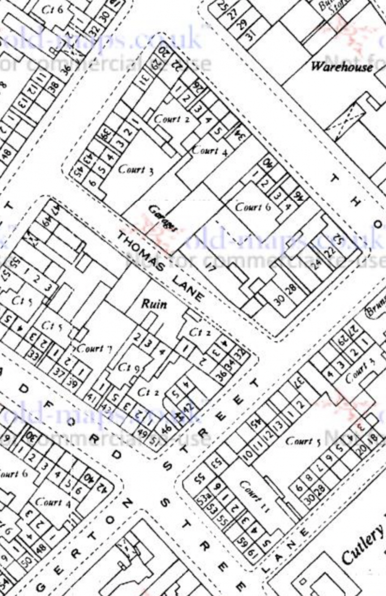
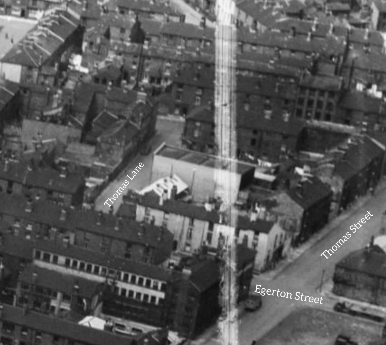
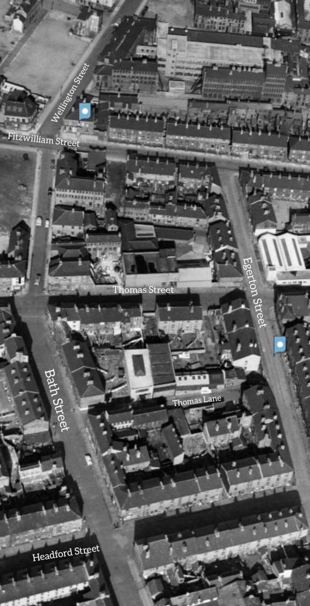
Afternoon all! I'm not sure if this is the right place for a request, but here goes. My Grandad's family lived on Thomas Street for a number of decades, stretching from around 1895 to the 1930s, but afterwards they relocated to Thomas Lane, which was a little Street between Bath Street and Egerton Street, Broomhall. Anyway, it turns out that they were living at number 5, as confirmed by both the 1939 Register, family documents, and a rather interesting newspaper article from that year. I've had a bit of trouble pinpointing the location of number 5 Thomas Lane, as there are no references to it being in a court, and no specific photographs of the street exist (I've included two from Britain from Above.) Even the 1905 Goad fire insurance maps cut off right before the street is covered! I was wondering if anyone on here knew any more about the area, or where the house might have been? Thanks, Lewis Waddingham

-
Link to: Owler Lane High School. https://www.sheffieldhistory.co.uk/forums/topic/13344-owler-lane-high-school/
-
It would probably have been Gentian Violet, an antimicrobial dye derived from coal tar. It's still around... but it's use much restricted in the UK nowadays after clinical research and availability of better alternatives to prevent/treat infection.
-
Yorkshire mining and the Tavistock Institute
Viners replied to Roger Arevalo's topic in Sheffield History Chat
Is Elsecar Colliery near Barnsley a good candidate? I see that the same coal seam (Haigh Moor) would have been mined from multiple pits, which makes it harder to pin down the actual location. It sounds like the research on sociotechnical systems was done at a mine that Ken Bamforth had worked in before becoming more of an academic. If you can establish that he worked at Elsecar, that might help to confirm it. 1 Source: https://breadtagsagas.wordpress.com/tag/elsecar-collieries/ "These areas of concentration were the discovery and analysis of industrial democracy underground in the Elsecar Collieries by Trist and Bamforth. The development of the theory of sociotechnical systems based on this and on insights from psychology and the social sciences." Tavistock Institute gets a mention. 2 Source: https://en.wikipedia.org/wiki/Eric_Trist "Organizational research In 1949, his organizational research work, studying work crews in at Elsecar Collieries, with Ken Bamforth, resulted in the famous article, "Some Social and Psychological Consequences of the Longwall Method of Coal Getting." This article highlighted aspects of the miners organisation that today would be termed lean or agile." 3 Source: https://en.wikipedia.org/wiki/Elsecar_Collieries "Elsecar Main Coal extraction proper began at Elsecar Main between 1905 and 1908 when shafts were sunk to the Parkgate seam at 333 metres. Other seams worked were the Silkstone, Thorncliffe and the Swallow Wood seams. The Haigh Moor, Lidgett and towards the end of the colliery's life, Kents Thick seams were also mined. The colliery closed in October 1983." This all fits roughly with the location of South Yorkshire and the mine where the work practices were found being "a recently opened seam" as at 1950/51. Trist and Bamforth were probably researching multiple things and might have visited lots of different mines, so references and quotes might have become a bit muddled. I saw a couple of mentions of other locations, but they don't fit as good as Elsecar does.


.jpg.a0662ce0cd9ba0025e89c626f9f01cac.jpg)
-RoutesShown.jpg.522e7a4bf8813eb4734a43122ea88980.jpg)