Search the Community
Showing results for 'coal pit lane'.
-
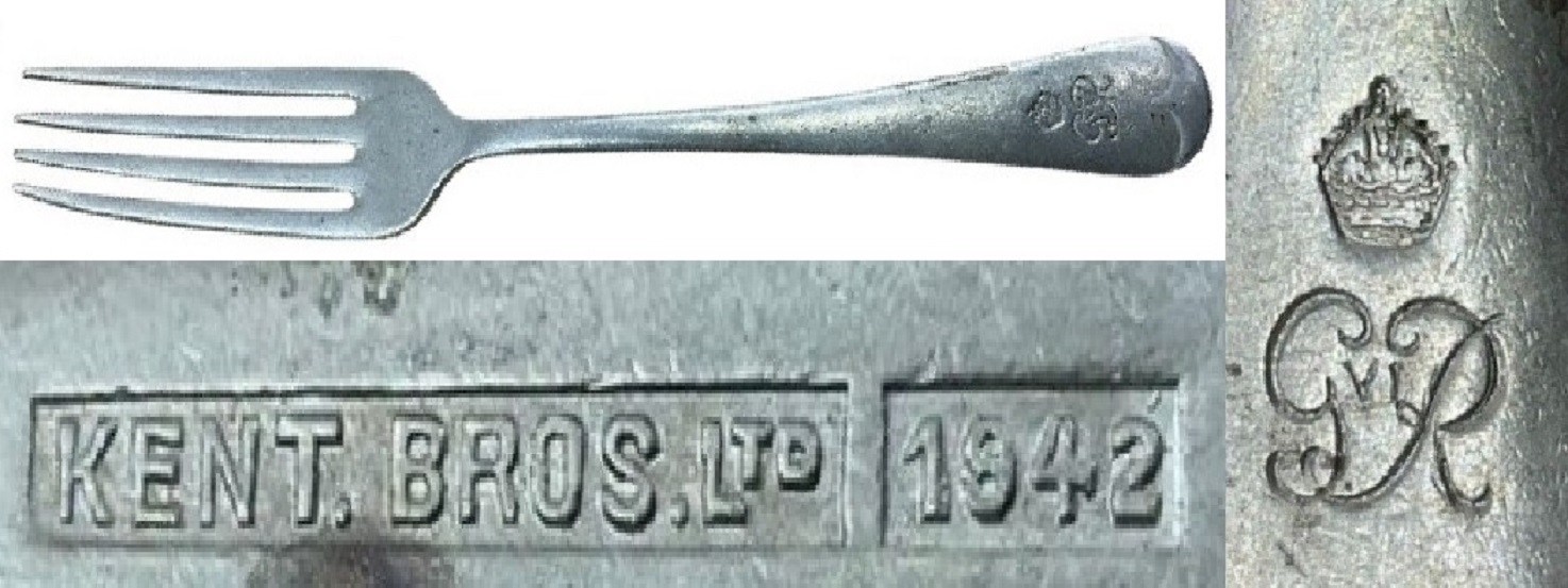
Hello, again I'm back at one of my previous posts. A belated thank you also to Loubaruch for your insightful contribution to the Bennett & Heron history. I am back though because of the mention of Kent Brothers (possibly not mentioned elsewhere on the Forum), a concern I had not come across until I saw online a suggested, military dining fork with a date on it, and indicated to have been made by that firm. The suggestion of the fork being military was no doubt because of the Royal cypher of King George VI shown its finial. There also is Kent Brothers Ltd and 1942. There is a full history of “Kent Bros” on the "Hawley’s Name on a Knife Blade" site but in brief they were formed in 1919 by brothers Percy & Leonard Kent on Broad Lane and “Ltd” in 1922 at 168 Broad Lane. Apparently wound up in 1969, when the chairman was E. H. Beighton. That was the surname Loubaruch quoted in his “B&H” history addition to this post. Other information was that B&H “bought out another manufacturer Kent Brothers who had a larger factory in Broad Lane, B&H then moved to Broad Lane in about 1960“. Is it coincidental that the name “Beighton” and the Broad Lane address are referenced with both companies? Were both companies run concurrently for a while or were B&H using the “Kent Bros” mark? Regarding the fork I am not sure it is necessarily for military use. Although the wartime date of 1942 was in King George VI’s reign the fork does not carry the “/|\” broad arrow mark associated with Government order items and typically seen on military stuff, including cutlery. A James Dixon & Sons example from 1942 with the “/|\” is below. I think there were other organisations that would have been using the King George VI cypher on cutlery. I think the General Post Office (GPO) would have been my top possibility. Any other suggestions? Kalfred


-
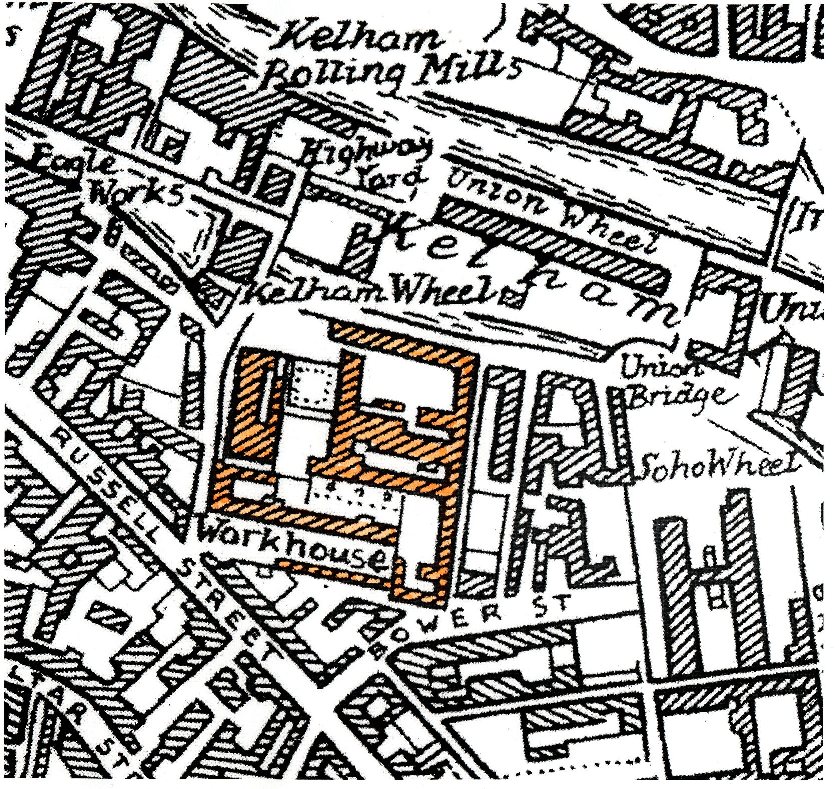
The original workhouse was situated in West Bar and was opened in 1733, hence Workhouse Lane, a remnant of which was still there in my memory. Basically right about where the roundabout is. Number 11 on the Gosling map. The Cotton Mill buildings (hence Cotton Street, Cotton Mill Row, and Cotton Mill Walk) were used as the Sheffield Union Workhouse from 1829 until 1881 (Fir Vale Workhouse opened). 18th June 1829 : The paupers having been removed from old workhouse to the new one, formerly the cotton mill, they were treated to 280lb of beef and 320lb of pudding; 317 paupers sat down. (Presumably the 600 pounds weight of food was meant for the lot of 'em, not each ) -------------------------- One for the people visiting The Fat Cat ... "map evidence suggests that the row of buildings backing onto Alma Street to the left of the current entrance to the Richardsons site (former Globe Steel Works) were not only part of the Workhouse, but also date back to the first cotton mill in 1805" Globe_Works.doc


-
Suggestion as to the origin of the name Jehu Lane. This one as recounted in Reminiscences of Old Sheffield, it's streets and it's people. From the 1870's Pages 213 & 214. "Leonard : Do you know what is said to be the origin of the name Jehu lane ? The tradition is, that when Mary Queen of Scots arrived in Sheffield for imprisonment at the Manor, this lane was the main road, and through it she had to pass. The streets had not been planned in expectation of such things as coaches rolling through them, and the lane astonished the Queen's coachman to such an extent that he ejaculated "Jehu!" — by way, I suppose, of invoking the tutelary genius of drivers in his difficulty. Everard : Credat Judcsus !" From a Google Search Originally a commander of chariots for Ahab, king of Israel, Jehu later led a revolt against the throne and became king himself. In the Bible, it is noted of Jehu that "he drives furiously" (II Kings 9:20). In the 17th century, English speakers began using jehu as a generic term meaning "coachman" or, specifically, "a fast or reckless coachman." Today, we are more likely to use the word in reference to reckless cabdrivers. The phrase drives like Jehu is encountered occasionally, too.
-
The photographs in earlier posts of housing due for demolition or in need of urgent repair you can see where donkey stoning the steps had been carried out. Even living in the shadow of the steelworks etc. and all the dirt and noise that was generated around them, they were still proud of their own home and kept it clean the best they could. Rear of No. 1 Wood Fold and back doorway of No. 175, Woodside Lane, 26th June 1957. demolished January 1960. s20695 It's unfortunate there isn't many photographs of interiors of the houses. Most of the photographs I've seen have been taken by the Council, Engineers & Surveyors Dept. or the Medical Officer of Health when reports have been needed to support the need for repair or demolition some through bomb damage but often through neglect by the Landlord. These photographs are often the only image there is of the house where they or their family lived. Sometimes only being able to say that space or the pile of bricks is all they have; or in my case the outside toilets of the neighbours. I only found that out because the City Engineers had written on the photograph identifying the derelict workshop they were attached to. From a map, discovered they were the outside toilets at the rear of Nos.1,3,5 & 7 Goulder Place, the houses were demolished some years before. "Goulder Place, workshop fronting Broughton Lane, taken 1st December 1962 by the City Engineers and Surveyors Office." The site is now part of Sheffield Arena Car Park. 1970, I took some photographs for a College project in the Carbrook area where my Grandmother had lived for a time. Demolition was well under way but there were some houses still occupied and even while demolition was going on around them, those steps were still being donkey stoned and the windows cleaned. Two ladies about their task thought I was from the Council but soon became friendlier when they discovered I wasn't. They hadn't wanted to move at first but were now looking forward to moving, and were missing their neighbours who'd already moved away.
-
This is the start of a new series of Then & Nows, based on a set of Tram photo's I have. Please post comments and memories as the topic progresses. 1. Brightside Lane 2. Norfolk Bridge 3. Penistone Rd / Langsett Rd Junction 4. Abbey Lane to Beauchief 5. Abbeydale Rd South 6. Abbeydale Rd 7. Wolsley Rd Heeley Bottom 8. Chesterfield Rd Woodsets 9. Kennings - Midland Station 10. Intake Terminus - Manor Top 11. Waingate, Blonk St, Wicker, Nursery St 12. Fitzalan Square 13. Neepsend 14. Furnival St - Brown St - Paternoster Row
-

Unidentified Public Houses and Refreshment Rooms
Ponytail replied to Ponytail's topic in Sheffield History Chat
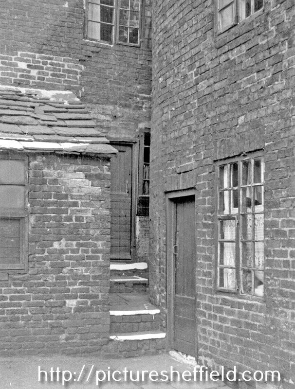
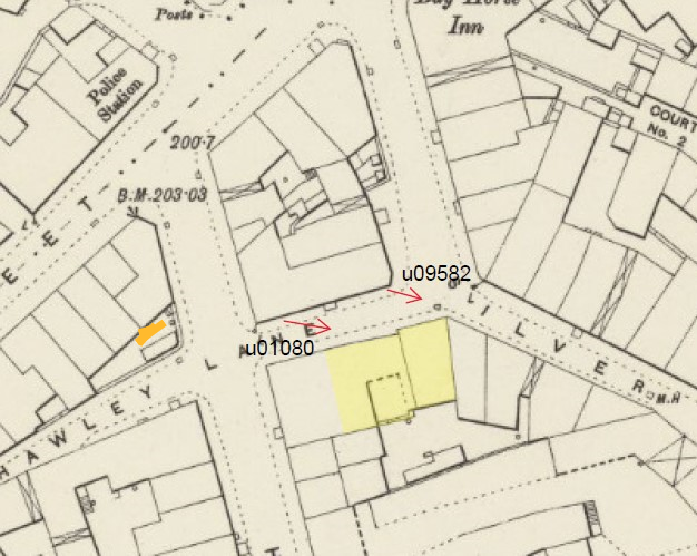
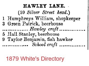
Hawley Lane looking towards Silver Street Head probable solution to unidentified u01080. Wondered if this photograph below could also be pinpointed. Thought at first it was the rear of the "Unidentified" but the back to backs shown on the map make it unlikely. It's possible it is the diagonally opposite corner of Hawley Lane and Hawley Croft. I'm open to suggestions. Yard behind Becketts, Hawley Lane, possibly corner of Hawley Lane and Hawley Croft. September 1898. u01083 "Unidentified" property shaded in yellow. "Behind Becketts" marked with an orange line. I was wondering who "Becketts" was. Was it the name of a Beerhouse/ Public House or the owner/ occupier of another building? If anybody has access, it would be useful if the Brewster Sessions revealed the name (if it had a name) of the "Unidentified" or Directories recorded a Beckett. I think Archaeo especially and Edmund have done a great job of getting this far can we get further?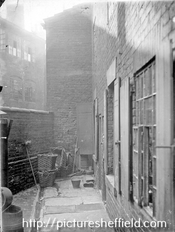
.jpg.13adf17a88bdccfe8e66726db0261121.jpg)
-
Unidentified Public Houses and Refreshment Rooms
Archaeo replied to Ponytail's topic in Sheffield History Chat
1901 Census (only heads named) - 1 Hawley Lane - Mary Horan, Provision dealer Back of 1 Hawley Lane - John W Horan, mining engineer 3 Hawley Lane - Joe Adamson, Sheffield Water Co labourer 5 Hawley Lane Old Reindeer - Frederick Booth, Inn Keeper -
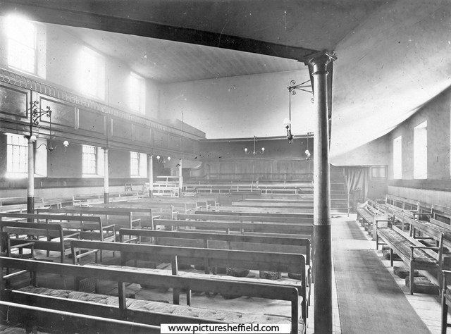
Interior of Friend's Meeting House, Hartshead. 1905.s05100 Friends' Meeting House, Hartshead after air raids. December 1940. https://www.picturesheffield.com/frontend.php?keywords=Ref_No_increment;EQUALS;s01202&pos=15&action=zoom&id=5060 Can anybody help with an image of the Friends Meeting House before 1940. Construction of "New" Friends Meeting House, Hartshead. 30th January 1964. https://www.picturesheffield.com/frontend.php?keywords=Ref_No_increment;EQUALS;s33106&pos=12&action=zoom&id=67278 Friends Meeting House, Hartshead. 1966. u11714 Is there a photograph of the Interior of this building? Friends Meeting House, corner of Vicar Lane and St. James Street. April 1991. https://www.picturesheffield.com/frontend.php?keywords=Ref_No_increment;EQUALS;s33107&pos=10&action=zoom&id=67279 Interior of Quaker Meeting House, St. James Street. 2015. https://www.picturesheffield.com/frontend.php?keywords=Ref_No_increment;EQUALS;arc01518&pos=2&action=zoom&id=66810 Plan of The [Quaker] Meeting House and burial ground, [1701] https://www.picturesheffield.com/frontend.php?keywords=Ref_No_increment;EQUALS;arc03652&pos=21&action=zoom&id=99202 Plan of The [Quaker] Meeting House and burying ground, and the widening of Meetinghouse Lane, [c. 1796-1801] https://www.picturesheffield.com/frontend.php?keywords=Ref_No_increment;EQUALS;arc03653&pos=22&action=zoom&id=99203 Plan of The [Quaker] Meeting House and burying ground, and the widening of Meetinghouse Lane, [c. 1796-1801] https://www.picturesheffield.com/frontend.php?keywords=Ref_No_increment;EQUALS;arc03654&pos=23&action=zoom&id=99204 Were the bodies reinterred?
-
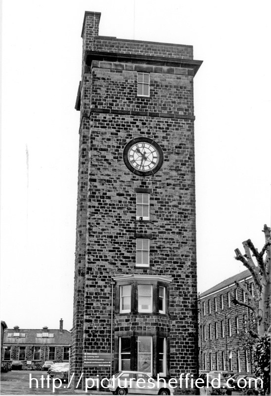
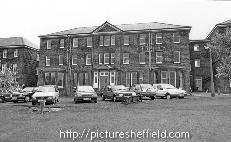
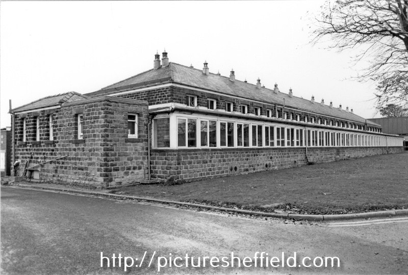
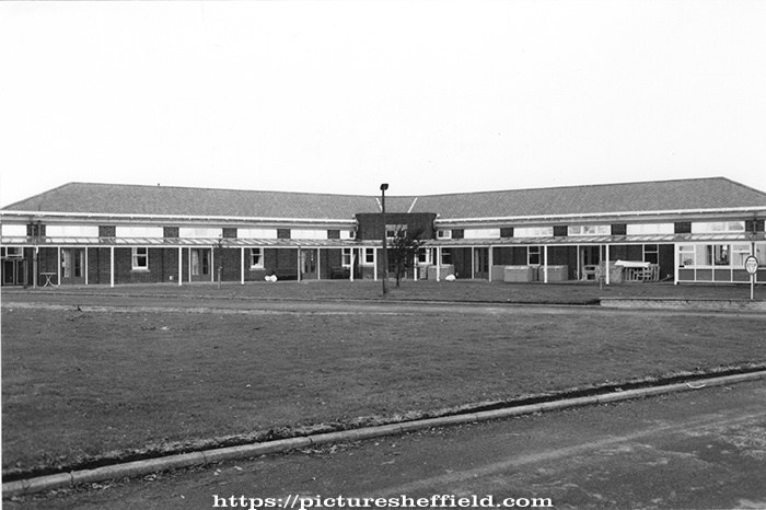
Lodge Moor Hospital was originally built in 1887, opening its 12 wooden wards on the 20th February 1888 as the Borough Smallpox Hospital. Demolition of Tuberculosis Huts, Crimicar Lane. 1955. s23386 s21093 View taken from an upstairs room of the main Crimicar Lane Isolation Hospital showing the WW2 concrete roofed air raid shelter. By June 1898 it was decided to add permanant stone buildings to comprise of accommodation for 146 patients. The administation block and isolation wards were occupied in 1901 and 6 wards each with 22 beds were completed by 1902. The Clock Tower and the Lodge at the main gates were completed in May 1903. For more information see: Lodge Moor Hospital 1887-1987, Lodge Moor Cenenary Brochure Ref: 362.11. See also The Hospital on the Moor, the spinal injuries unit Lodge Moor by Ella Goddard Ref: 362.197482. Clock Tower, Main Entrance, Lodge Moor Hospital. 30th October 1990. s23347 Administration Block, Lodge Moor Hospital. s23355 Infectious Diseases Wards (West Wards), Lodge Moor Hospitals23354 Respiratory Function Unit, Lodge Moor Hospital. s23353
-

Tram - Origin of the Name?
Edmund replied to dunsbyowl1867's topic in Sheffield Buses, Trams and Trains
Medlicott derives his "mile and three quarters" from the 1773 estimate above which states: "2,000 yards of double rail at 10s" (per yard). However Medlicott does not take into account that there would need to be two double rails (an up line and a down line) so 2,000 yards would only get you 1,000 yards away, about 0.6 miles. Assuming that originally, 60 years before the 1832 map, the route would have been almost a straight line, that gets you to the region of the Cricket Inn Road Engine House. There were then another 1,000 yards of rail purchased to access various satellite pits. EDIT: Taking into account the map (next post), volume of coal (53 corves a year), I think the 1773 estimate would NOT need two way working, so the 2000 yards does give a guide to the extent of the waggonway. Going up the approximate route of Duke Street, 2,000 yards would get you past the Gin Stables and as far as the Manor Sandstone Quarry (600 yards east of Belle Vue in 1850) - maybe the sandstone quarry used to be a coal pit? According to Medlicott in his 1981 PhD thesis, the Manor pit near Corker Bottoms was not opened until 1823. The "Manor pit" referred to before that, was renamed as "Woodthorpe pit" sometime after 1805. Woodthorpe Colliery is 1/4 mile north of Manor Top, so too far to reach in 1774, especially with only 2,000 yards of rail on hand. -
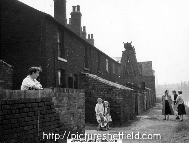
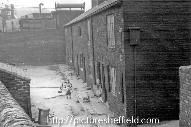
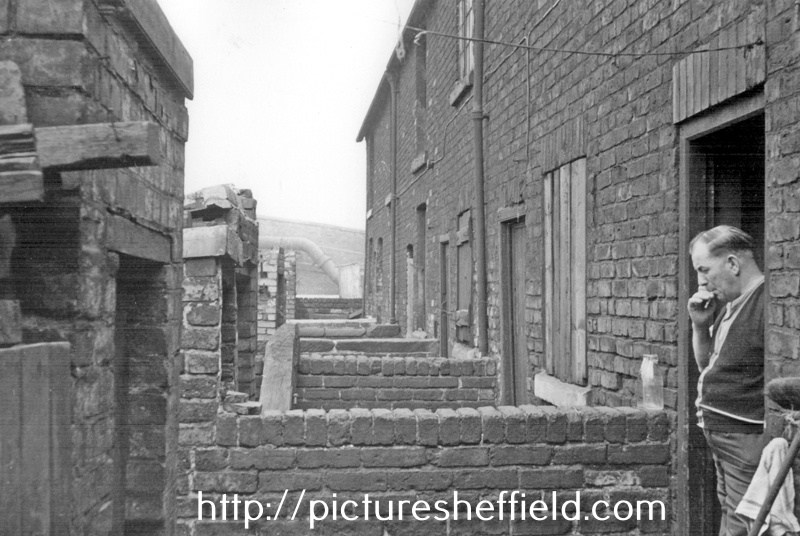
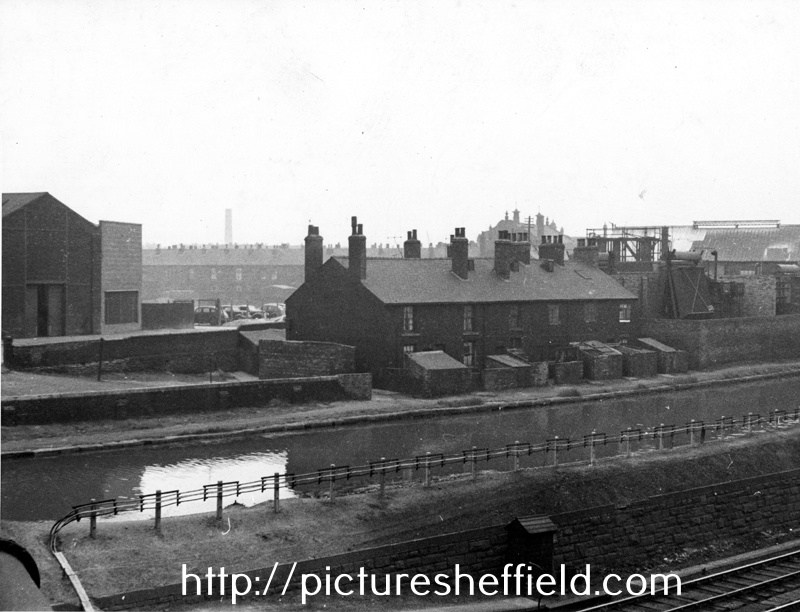
Canal Cottages, Tinsley Park Road (demolished 1958) showing the Electricity Sub Station (right) and Sheffield and SYK Navigation from Broughton Lane Bridge. Photographs taken 8th May 1957 by Kodak Medical, Medical Officer of Health. Llewellyn Roberts. Properties demolished 1958. s24779 Mr. Vincent Lawrence Bryan with his children Stephen John; Kathleen and Pauline Mary in front of Nos. 7-12, Canal Cottages, Tinsley Park Road with the Sheffield and SYK Navigation right. s24778 The Bryan Family children who lived at No. 5 showing Nos. 6-1, Canal Cottages, Tinsley Park Road, looking towards Electric Sub Station and Chemical Works.t00515 Information from Stephen Bryan who can be seen, aged around 18 months, with his sister Kathleen aged about 4 years. Stephen loved to play with the brush in the puddle that frequently gathered in the yard. Mr. Vincent Lawrence Bryan in the doorway of No. 12 and Nos.11-7, Canal Cottages, looking towards Broughton Lane Bridge. t00514
-
Thomas and Phyllis Lilian Cooper were married in Oct/Nov/Dec 1935 in Stoke on Trent. Phyllis was the daughter of Fred (a colliery wages clerk at Parkhouse pit) and Elizabeth, of Woolstanton. From the Sheffield Daily Telegraph of 17th October 1939: "WARD - On October 15th, at Sister Needham's Nursing Home, Clarkehouse Road, to Phyllis (nee Cooper), wife of Thomas Ward , of 11 Greystones Drive, a daughter." Daughter Gillian was born on Phyllis' 31st birthday. If he was in the army (as opposed to the RAF) in South East Asia, the Fourteenth Army was the overarching organisation. Within that, the York and Lancaster Regiment might be the most likely options for a Sheffield lad. The 1st, 2nd, 8th and 9th Battalions were under the Fourteenth Army operating in India and Burma. There is information on the Y&L here (though details are on a 'paid for' basis: https://www.wartimememoriesproject.com/ww2/allied/regiment.php?pid=1458 Also here: http://ww2talk.com/index.php?search/22254928/&q="york+and+Lancaster"+burma&o=relevance
-
Booth & Co., Park Iron Works, Brightside Forge & Royds Mill.
Ponytail replied to Ponytail's topic in Made In Sheffield
Plan of Salmon Pastures held of the Duke of Norfolk by Thos. Sambourne. 1792. Surveyor: William Fairbank II. https://www.picturesheffield.com/frontend.php?keywords=Ref_No_increment;EQUALS;arc02669&pos=7&action=zoom&id=91474 Shows part of the River Don, and the Goight and Foundry; (Warren Street, Royds Mill and Farm.) fields etc. lettered and listed with particulars: a. Proposed to be taken on lease for 99 years. b. Proposed to be given up to the Road. c. Lower Salmon Pastures, as proposed to be altered. d. Held by Booth & Co., part of the Netherfield. e. Island. f. Upper Salmon Pastures. g. Lower part. h. Upper part, proposed to be kept for sand. Held by John Booth & Co. A map of Salmon Pastures held of the Duke of Norfolk by Wm. and Geo. Binks.1787. Surveyor: William Fairbank II. https://www.picturesheffield.com/frontend.php?keywords=Ref_No_increment;EQUALS;arc02667&pos=5&action=zoom&id=91471 Between (Warren Street) and the goight and the Don; closes, etc., numbered and listed with particulars. Includes the Nether Field and the old wheel; numerical list with acreages; field names given on the map. (Royds Mill and Farm.) It's probable that Burton took over the Mill before 1720. 1718/19, Burton Dam appears in the Repair account. 1737 William Burton took a 21 year lease of "corn mill called Attercliffe Mill near Washford Bridge" 1756 lease still in the name of Burton, 1761 the property listed in his will. 1765, Hartop, ironmasters had a 21year lease; 1782, Binks, Booth and Hartop, the lease recording the poor condition of Royds Mill and Wheel and measures needed by the new tenants to rebuild it and improve the water supply. 1794, Booth & Co. recorded at Royds Mill & Wheel. The partnership were at this time on the south side of the River Don, developing the Park Ironworks. 1821, Royds Works advertised for sale or let by Auction described as a Corn Mill; Forge and Rolling Mill. A Map of the Turnpike Road from Westforde [Washford] Bridge to the Mill Goite, c.1760-1770. Surveyor: John Needham. https://www.picturesheffield.com/frontend.php?keywords=Ref_No_increment;EQUALS;arc02665&pos=4&action=zoom&id=91373 Outline of the mill wheel and goit; 'measurement of land required to make the road straight.' (Royd's Mill Street) Marked: Mr. Burton Lane. River Dun (Don); Weste Ford Bridge (Washford) (Royds Mill and Farm. Windsor Street.) For more information about Royds Mill and Wheel, see "Water Power on the Sheffield Rivers" , edited by David Crossley with Jean Cass, Neville Flavell & Colin Turner. -
Eyre Street, Lots of Thomas Fisher and Edwin Unwin, in George Curr’s land late Dr Frith's, [1827] https://www.picturesheffield.com/frontend.php?keywords=Ref_No_increment;EQUALS;arc04101&pos=5&action=zoom&id=103589 Shows Jessop Street, Jessop Lane, Eyre Street Earl Street and Eyre Lane. Owners / Tenants marked: Thomas Fisher, Edwin Unwin, William and John Alsop / Joseph Foote. According to the article in the Star, dated 19th January 2023. "John’s brother, George (1749-1826)" Is this "George" or another relative?
-
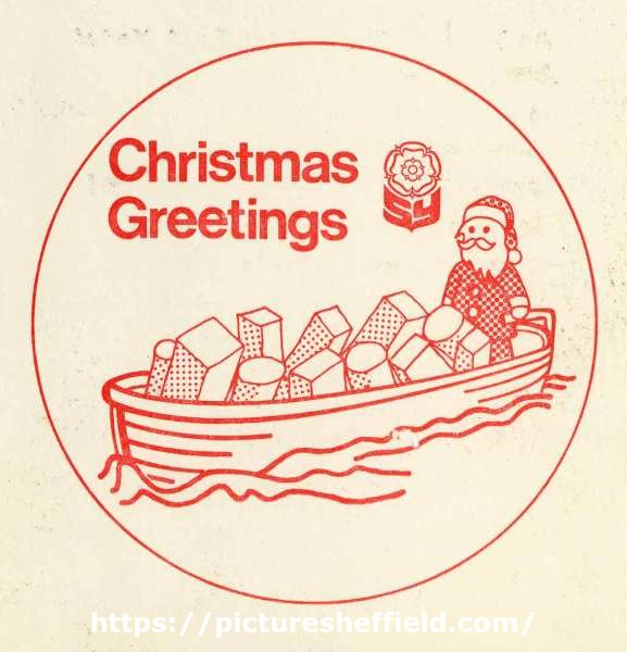
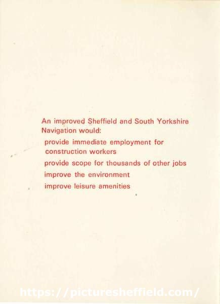
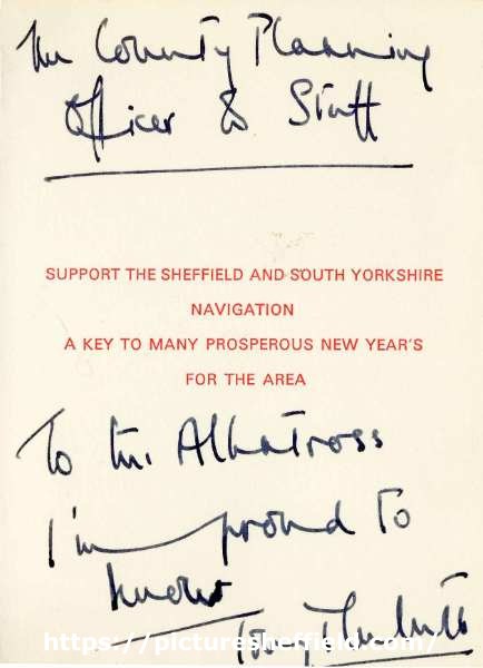
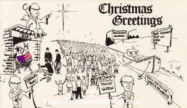
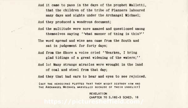
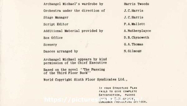
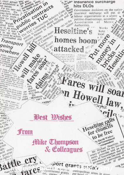
South Yorkshire County Council Christmas Cards. South Yorkshire County Council Christmas Card - South Yorkshire Waterways. arc07248arc7249arc07250 An improved Sheffield and South Yorkshire Navigation would: Provide immediate employment forconstruction workers Provide scope for thousands of other jobs Improve the environment Improve leisure amenities Support the Sheffield and South Yorkshire Navigation - A key to many prosperous New Year’s for the area. Original at Sheffield City Archives: SYCC/PL/31/13 (altrefno: SYCC CB 681). South Yorkshire County Council Christmas Card - South Yorkshire Waterways / County Structure Plan. arc07245arc07246arc07247 Includes reference to Thwaites Progress (Roy Thwaites was Deputy Leader of the County Council, 1979-1980 and Leader, 1980-1986), Cornwell Tours (John Cornwell was Deputy Leader, 1981-1986), SYCC Transit 'Gloria', South Yorkshire Yacht and Cobble Club, EIP, and (inside the stable) Structure Plan Written Statement. And it came to pass in the days of the prophet Malletti, That the children of the tribe of Planners laboured Many days and nights under the Archangel Michael; And they produced a wondrous document; And the multitude were sore amazed and questioned among themselves saying ''What manner of thing is this?'' The word spread and wise men came from the South and sat in judgement for forty days; And from the Shore a voice cried ''Hearken, I bring glad tidings of A great widening of the waters;'' And lo! Many strange miracles were wrought in the land of coal and steel from that day; And they that had ears to hear and eyes to see rejoiced. (But the Herodians plotted that they might destroy him and the archangel Michael marvelled because of their unbelief) Revelation chapter 70 s.182-3 sched 16. Archangel Michael's wardrobe by Harris Tweeds Orchestra under the direction of J. C. Harris Stage Manager J.C. Harris. Script Editor F. A. Mallett. Additional Material provided by A. Nutherplayce. Box Office D. B. Chynoweth. Scenery G. A. Thomas. Dances arranged by N. Gilmour. Archangel Michael appears by kind permission of the Chief Executive. Based on the novel '"The Passing of the Third Floor Buck". World Copyright Sixth Floor Syndicates Ltd. If your structure plan fails to give complete satisfaction, please write to S. Gascoigne, Consumer Protection Officer. Original at Sheffield City Archives: SYCC/PL/31/13 (altrefno: SYCC CB 681) South Yorkshire County Council Christmas Card - best wishes from Mike Thompson and Colleagues. arc07243 Original at Sheffield City Archives: SYCC/PL/31/13 (altrefno: SYCC CB 681) arc07244 This card depicts the Prime Minister, Margaret Thatcher, and the Secretary of State for the Environment, Michael Heseltine, carving up a Local Government Pudding. This related to the Government's plans to abolish Metropolitan County Councils in 1986. Original at Sheffield City Archives: SYCC/PL/31/13 (altrefno: SYCC CB 681). South Yorkshire County Council - final Christmas Card. 1985.arc05252 Image from Sheffield Local Studies Library: MP Folder 2.


-
Upper Forge (Forge Dam), Porter Brook at Ivy Cottage Lane, c. 1826 https://www.picturesheffield.com/frontend.php?keywords=Ref_No_increment;EQUALS;arc06218&pos=56&action=zoom&id=102553 Detail from Plan of the Whiteley Wood Works and other property belonging to Samuel Mitchell and Co., [1826] (arc03974). Plan of the Whiteley Wood Works and other property belonging to Samuel Mitchell and Co., [1826] https://www.picturesheffield.com/frontend.php?keywords=Ref_No_increment;EQUALS;arc03974&pos=55&action=zoom&id=102552 From left to right: Dam, Upper Forge, Old Dam, road from Brookhouse Green, wood, plantation, meadow, plantation, dam, Whiteley Wood works, forge, plantation, Bottoms Wood, The Heys, part of Dodge Field, part of Little Field, Woody, Croft, Holme Bank, dam, wheel, Porter Field, road to Sheffield and road to Nether Green. Key: In Upper Hallam - Forge Dam Banks and land adjoining, plantation, lower part of Dodge Field, Upper Holme Bank, Lower Holme Bank, road through Holme Bank, road along Porter field, Porter field, grinding wheel, dam goight banks, etc. In Ecclesall Bierlow - House Woody Bottom Lane and wood, plantation and goight, meadow, road along top of plantation, road through meadow, plantation and rad through, dams with the banks, Whiteley Wood Works Houses, Bottoms Wood, the Heys the part pasturable, road and remaining part, road from the Heys to Whitley Wood Chapel, plantation and chapel, part of Little Field, Woody Bank, Croft, road to the grinding wheel and Woody part adjoining the River. Whiteley Wood Works and Wire Mill Dam, Porter Brook, Whiteley Wood Road (formerly the works of Thomas Boulsover), c. 1826. https://www.picturesheffield.com/frontend.php?keywords=Ref_No_increment;EQUALS;arc06219&pos=57&action=zoom&id=102554 Detail from Plan of the Whiteley Wood Works and other property belonging to Samuel Mitchell and Co., [1826] (arc03974).
-
Arundel Street. Section. Levels taken for a common sewer from Porter Street to the River Porter near the White Lead Works, [1825] https://www.picturesheffield.com/frontend.php?keywords=Ref_No_increment;EQUALS;arc04027&pos=63&action=zoom&id=103213 Refers to Arundel Street, end of Duke Street, end of Earl Street, end of Eyre Lane, Porter Lane, and a culvert.
-
Land of John Watson and T. B. Holy, Arundel Street, [1830] https://www.picturesheffield.com/frontend.php?keywords=Ref_No_increment;EQUALS;arc04032&pos=67&action=zoom&id=103277 Shows Bye Goight, River Porter, land sold by James Fernley to Ellin and Ingall; Pearson and Griffith; Josh. Houldsworth; Houldsworth Lane; and Thomas Booker. Lands of T. Holy on the south side of Sheffield, showing land schemed for gardens and roads, c. 1804 and 1818 https://www.picturesheffield.com/frontend.php?keywords=Ref_No_increment;EQUALS;arc04030&pos=65&action=zoom&id=103260 Shows Arundel Street, Furnival Street, Eyre Street, Charles Street, Browne Street [Brown Street], [Arundel Lane]. Refers to Daniel Darwent, Benjamin Hadfield, Robert Hide, Benjamin Raworth [Rayworth], Joseph Skinner, Thomas Potter, David Davey, Thomas Smith, Henry Froggatt, Joseph Cantrill, Josh. Skinner, William Butcher, William Morley, Firth and Co., Charles Hutchinson, Robert Colyer, Josh. Clarke, James Linley, Jonathan Helliwell, Robert Hide, Peter Frith, and William Colwell.
-
A map of the Dams, Goights and other Works belonging to the Pond Forge Co. together with some other intermediate properties. 1820. https://www.picturesheffield.com/frontend.php?keywords=Ref_No_increment;EQUALS;arc04213&pos=73&action=zoom&id=105197 Boardman's Bridge, wear [weir], Porter Brook, goight, River Sheaf, Upper Dam, Sheaf Lane, bridge, Upper Forge Wheel, dam, Upper Forge, Sheaf Mill, steam engine, Lower Forge, grinding wheel, arched goight, tail goight, Shude Hill, Hospital Bridge, Hospitals, Sheaf Bridge, Castle Orchards Wear [weir], River Dun [River Don], Pond Street, Forge Lane, Pond Well Hill. Late Joseph Ward, John Hounsfield, Josiah Blackwell, late Abraham Wright, S. Woodcock and Sons, Joseph Blackburn, Thomas Mearbeck and Co., S. Rawson and Co. [?Thomas Rawson and Co], Joseph Shimmeld, John Vickers, Sheffield Gas Light Co., S. and S. Darwin, Sarah Beeley, Widow Beardsall, John Hale, Widow Badger, and J. B. Ward.
-
History of Attercliffe and the Benjamin Huntsman steelworks
Ponytail replied to a topic in Sheffield History Chat
A Plan of two Closes, Buildings, etc. held under the Duke of Norfolk by Samuel Scholey and W. Scrapper. 1763. https://www.picturesheffield.com/frontend.php?keywords=Ref_No_increment;EQUALS;arc02680&pos=75&action=zoom&id=91520 Surveyor: William Fairbank II. This is one of the enclosed strips south-west of Worksop Road; acreages listed; explanation of the buildings. Marked: Close in Saml Scholey's possesion. Close in W. Rapper's possesion. Included in the next strip: B. Huntsman's Furnace; a. Part of Benjamin Huntsman's Yard; b. A shed erected by him; c. Part of a Mill House built by him; d. A piece of Ground proposed to be taken by him for enlarging his Works; e. g. Buildings; f. a Yard; h. h. i. Gardens, held by William Crapper. k. Another part proposed to be taken by Benjamin Huntsman for enlarging his works. the etc. in the next strip. Also marked: Lands vested in the Capitol Burgesses of Sheffied; Attercliffe Green; (Attercliffe Steel Furnace, Worksop Road, Shirland Lane.) -
What does "main" mean in a colliery name ?
Lysanderix replied to JS2021's topic in Sheffield History Chat
My finding of the Dore Colliery came about whilst I was researching the early days of the NCB….and Dore was listed in an official publication detailing all the coal mining companies, including those which were dormant. -
What does "main" mean in a colliery name ?
Ponytail replied to JS2021's topic in Sheffield History Chat
Rotherham Main Colliery. https://www.nmrs.org.uk/mines-map/coal-mining-in-the-british-isles/yorkshire-coalfield/sheffield/rotherhammain/ https://en.m.wikipedia.org/wiki/Rotherham_Main_Colliery Rotherham Main Colliery at Canklow. Dalton Main Colliery Ltd. https://en.m.wikipedia.org/wiki/Dalton_Main_Collieries_Ltd. Aldwarke Main Colliery https://en.m.wikipedia.org/wiki/Aldwarke_Main_Colliery Aldwarke Main Colliery Explosion 1875. https://www.nmrs.org.uk/mines-map/accidents-disasters/yorkshire/aldwarke-main-colliery-explosion-rotherham-1875/ Aldwarke Main Colliery Accident 1904. https://www.nmrs.org.uk/mines-map/accidents-disasters/yorkshire/aldwarke-main-colliery-accident-rotherham-1904/
-
What does "main" mean in a colliery name ?
Ponytail replied to JS2021's topic in Sheffield History Chat
Maltby Colliery, formed as Maltby Main Colliery Co. Ltd. 1907. https://www.nmrs.org.uk/mines-map/coal-mining-in-the-british-isles/yorkshire-coalfield/sheffield/maltby-colliery/ -
Does anyone know whereabouts on Claywheels Lane they were located?
-
Plan of proposed extension of Eyre Street to Porter Street and also the proposed widening of Porter Bridge. 1845. https://www.picturesheffield.com/frontend.php?keywords=Ref_No_increment;EQUALS;arc06810&pos=76&action=zoom&id=106241 Also shown are Brammall Lane [Bramall Lane], Hereford Street, Sylvester Street, Cumberland Street, and the Porter Brook.