Search the Community
Showing results for 'coal pit lane'.
-

Old Sheffield tram routes - bit of confusion !
Viners replied to Roger Stevenson's topic in Sheffield History Chat
Just had a look at some of the old route maps and posts on the subject and saw mentions of routes being changed and extended. There's a reference to there once being an 'Ecclesall terminus' and the route being extended 'to Millhouses Lane'. Perhaps the answer is the trams did go that way at one time but they re-routed it as the network was extended? If the maps tend to show the final layout of the system, it might not show how it changed over time? https://www.mediastorehouse.co.uk/sheffield-city-archives/maps-plans/sheffield-corporation-tramways-parks-14050142.html -
A Plan of the Mill Sands in Sheffield divided into Gardens and Tenements held of the Earl of Surrey. 1781. https://www.picturesheffield.com/frontend.php?keywords=Ref_No_increment;EQUALS;arc02092&pos=162&action=zoom&id=76129 A large plan of the whole area between the Town Mill Dam and the River Don including the Town Mill and the Steel Furnace; most of the Tenements (coloured) are Gardens but there are some Houses, Smithies, Skinner's Yards, etc; also Cutlers Grinding Wheel, the Tail Goight, Steel Furnaces; numerical list with Tenants names, descriptions and measurements. The Isle, held by John Goulden and John Froggatt of the Burgesses, showing Land taken for widening the street in 1795. https://www.picturesheffield.com/frontend.php?keywords=Ref_No_increment;EQUALS;arc03800&pos=1337&action=zoom&id=99444 Marked: Castle Green; Street called Under the Water; Waingate; Weir; bye Wash; bye Goit; River Dun (Don) & Lady's Bridge. Town Land in Waingate, Castle Green and Bridge Street, c.1780 - 1790. https://www.picturesheffield.com/frontend.php?keywords=Ref_No_increment;EQUALS;arc04279&pos=4&action=zoom&id=105930 Marked Castle Green Head, Wain Gate, Castle Green, New Hall Street, Under the Water, Water Lane. John Marshall (warehouse and steel furnace, tenements and workshops), Earl of Surrey’s land, [?new] Shuttle, Town Mills Tail Goight, Well, Samuel Morris Tenement, Wear [Weir], The Isle, arched watercourse. Also marked are 74 Jeremiah Ward; 76 Ann Castleton; 77 J. Spooner; 80-81 Dr Hawksley; 82 William Poles; 83 William Lord; 84 Ezra Twigg, William Parker, William Haworth; 86 Poor House belonging to the Town; Margaret [Lowe?], Widoe Chapman; Barnard Hanson; 86 Paul Wilkinson. [No No.] Thomas Wilde; 87 Charles Littleworth, John Spooner; 89 Late George Morton now Stephen Smith; 90 Joshua Wigfull; 91 Thomas Wilde; ; 94 - Martha Springfield, 96 John Scholey / Aughton / late John Turner, water land / well, Thomas Wilde William [Pill?]; 97/97a Samuel Genn and James Smith; 99 – Town land (houses and several workshops), James Kenyon, 101 - Henry Crawshaw. Plan of the Orchard and Garden in the Mill Sands belonging to the Duke of Norfolk, c. 1770-1778. https://www.picturesheffield.com/frontend.php?keywords=Ref_No_increment;EQUALS;arc03058&pos=27&action=zoom&id=96543 Full title: A Plan of the Orchard and Garden in the Mill Sands belonging to the Duke of Norfolk, the tenant right whereof is convey'd from [M.] Bridden to J. Marshall; and of the parcel of Town Land and tenements thereon contiguous to the said Orchard Property between Mill Sands, the Mill Tail Goight and the River Dun [Don]. Includes The Isle. Also shows a bridge. Named: Widow Broadbent; Dennis Pepper. Two tenements in Under the Water occupied by Robert Turner and Nanson and Co. 1804. https://www.picturesheffield.com/frontend.php?keywords=Ref_No_increment;EQUALS;arc03801&pos=154&action=zoom&id=99472 Plan of the Cutler’s Grinding Wheel belonging to the late John Vickers at the Town Mill showing also some adjoining property. 1828. https://www.picturesheffield.com/frontend.php?keywords=Ref_No_increment;EQUALS;arc03657&pos=149&action=zoom&id=99207 Marked: Bridge Street; Colson Crofts; Mill Lane; Water Wheel; Grinding Wheel & Goight (Goit).
-
The Isle and Town Corn Mill, Weir & Goit
Ponytail replied to Ponytail's topic in Sheffield History Chat
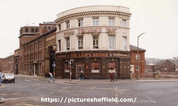
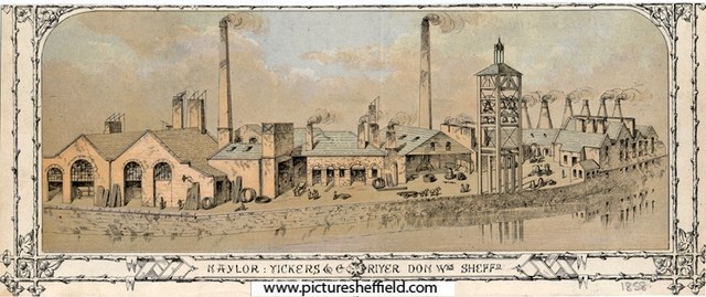
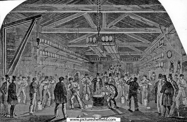
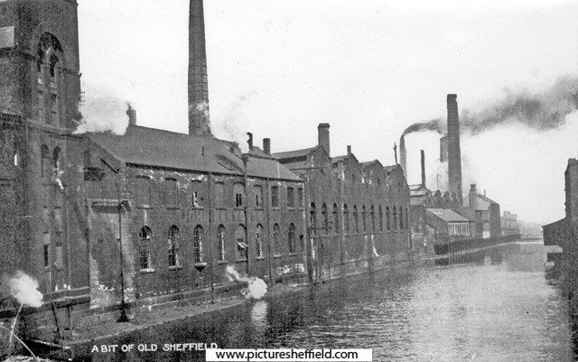
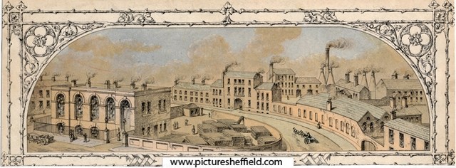
The Corn or Town Mill as it was known, was the most likely site of the medieval Corn Mill mentioned in the 12th Century built by the De Lovetots. The Mill in 1664 was leased to Thomas Cooke and Edward Hobson. In 1740 Thomas Ford held the lease and built a Cutlers Wheel adjacent. 1761, John Vickers took a 21year lease of the mill and "that cutler wheel of one end and ten troughs standing near the said corn mill and erected about ten years since at the sole expense of Thomas Ford late lessee" Building lots on Mill Sands. 1787. https://www.picturesheffield.com/frontend.php?keywords=Ref_No_increment;EQUALS;arc04166&pos=52&action=zoom&id=104251 The rough draft was made on arc04165. This plan is a fair copy. Tenants / owners: John Gallimore, Zachary Webster, Thomas Anderton, John Vickers, Joseph Jennings, James Duke, Richard Yeomans, William Marsden, James Green, George Taylor, and Jonathan Marshall. A plan of the Millsands, subdivided into gardens held of the Earl of Surrey, c. 1780s Marked: Town Wheel, Town Wheel Dam, River Don, etc. https://www.picturesheffield.com/frontend.php?keywords=Ref_No_increment;EQUALS;arc04165&pos=51&action=zoom&id=104250 Tenants: Benjamin Burdekin, William Grubb, George Taylor, John Barber, Nathaniel Smith, William Robinson, John Maltby, Thomas Sykes, John Arundel, John Buxton, James Bate, Zachary Webster, John Marshall, William Hill, Edward Frane, Joseph Bellamy, Joseph Barber, Robert Hague, John Milner, Charles Marshall, Thomas Wigfall, Joseph Jennings, Anne Lancelot, Hannah Moorhouse, Ann Matthews, widow of Edward Dickinson, Richard Yeomans, James Bettany, John Vickers, William Marsden, Ann Crofts, John Marshall, - Goodwin Clark, Denis Belk, Thomas Broadbent, Benjamin Bamforth, Luke Cadman, Hannah Haslehurst. Property includes houses, gardens, dye house, smithy, workshops, stable, yard, furnaces, a skinners yard, the town mill, etc. Plan of several building lots in the Mill Sands. 1787. https://www.picturesheffield.com/frontend.php?keywords=Ref_No_increment;EQUALS;arc03060&pos=42&action=zoom&id=96711 Property between the Town Mill Dam and the River Dun [Don]. Marked: Town Mill Dam; John Vickers; John Gallimore; Zachery Webster; John Anderton. Plan of the Ground in the Mill Sands [Millsands] held of the Duke of Norfolk by the Young Club. 1792 https://www.picturesheffield.com/frontend.php?keywords=Ref_No_increment;EQUALS;arc03063&pos=44&action=zoom&id=96713 Property between Mill Sands and the Town Mill Dam, including a narrow lane. 1794, Vickers held the mill and the wheel with 34 troughs employing 38 men. Plan of the lot of ground in Mill Sands on which several houses are erected by, or for James Duke. 1796. https://www.picturesheffield.com/frontend.php?keywords=Ref_No_increment;EQUALS;arc03068&pos=50&action=zoom&id=96722 Property between Mill Sands [Millsands] and the River Dun [River Don]. Plan of the tenements and ground in the Mill Sands held of the Duke of Norfolk. 1796. https://www.picturesheffield.com/frontend.php?keywords=Ref_No_increment;EQUALS;arc03067&pos=49&action=zoom&id=96721 Property, including steel furnaces, between Mill Sands [Millsands], the Tail Goight from the Town Mill and the River Dun [River Don]. 1805 the wheel and the mill were sold to Vickers by the Norfolk Estate. From 1825 Vickers developed the area of Millsands into a Steelworks with a rolling mill and the following years Naylor, Vickers were manufacturing steel on a large scale. The Rate books for 1845/6 show the Grinding Wheel empty; advertised to let 1849 but not recorded in 1855. Vickers was in the process of building a new Steelworks at Brightside when the Flood of 1864 caused much damage to the site at Millsands and Edward Vickers, George Naylor Vickers, Thomas Edward Vickers & Albert Vickers, firm of Naylor Vickers & Co. made a claim. Messrs. Naylor Vickers Co. https://sheffieldfloodclaimsarchive.shu.ac.uk/claimSummary.cfm?claim=2-2267 https://sheffieldfloodclaimsarchive.shu.ac.uk/claimSummary.cfm?claim=10-2267 Benjamin Vickers, damage to arch of Corn Mill. (Is this the Town Corn Mill) https://sheffieldfloodclaimsarchive.shu.ac.uk/claimSummary.cfm?claim=5-4766 George Dalton, night watchman to Naylor, Vickers & Co. https://sheffieldfloodclaimsarchive.shu.ac.uk/claimSummary.cfm?claim=5-4685 John Wood and others working at Naylor, Vickers & Co. https://sheffieldfloodclaimsarchive.shu.ac.uk/claimSummary.cfm?claim=3-2942 George Johnson contracting foreman at Naylor, Vickers & Co. https://sheffieldfloodclaimsarchive.shu.ac.uk/claimSummary.cfm?claim=5-4542 William Hopkins, warehouseman & office keeper, of Messrs. Naylor, Vickers & Co. Offices Millsands. https://sheffieldfloodclaimsarchive.shu.ac.uk/claimSummary.cfm?claim=5-4287 John Wood forgeman at Naylor, Vickers & Co. https://sheffieldfloodclaimsarchive.shu.ac.uk/claimSummary.cfm?claim=7-6157 Charles Firley Biclanski, merchants clerk at Naylor, Vickers & Co. https://sheffieldfloodclaimsarchive.shu.ac.uk/claimSummary.cfm?claim=1-668 1877, Vickers sold the site of the grinding and part of the mill dam to the brewers Tennant & Moore. Rate books of 1850's to the 1870's the Corn Mill is let to Samuel Price. Samuel Price snr. & Samuel Price jnr. (firm of Samuel Price & Son) corn miller, Millsands made a Flood Claim: https://sheffieldfloodclaimsarchive.shu.ac.uk/claimSummary.cfm?claim=3-2753 Samuel Price snr. had his claim for a broken leg dismissed: https://sheffieldfloodclaimsarchive.shu.ac.uk/claimSummary.cfm?claim=9b-54 Mary Marsden, spinster, Sam L. Price's, Millsands. https://sheffieldfloodclaimsarchive.shu.ac.uk/claimSummary.cfm?claim=4-3714 Joseph Walton, engine tenter, Rice's Yard, Millsands. (Is this a mistake? Should it be Price's Yard?) https://sheffieldfloodclaimsarchive.shu.ac.uk/claimSummary.cfm?claim=5-4660 Mary Dobbins, stable yard, Millsands. (Was this the stable of Naylor Vickers or the Corn Mill?) https://sheffieldfloodclaimsarchive.shu.ac.uk/claimSummary.cfm?claim=3-2604 There are other claimants at "Millsands" ... Some are identified as "Club Yard" (possibly Young Club in plan of 1792) "New Yard" "Millsands Leather Works" Also: William Parker, Spade & Shovel Maker, Millsands. https://sheffieldfloodclaimsarchive.shu.ac.uk/claimSummary.cfm?claim=7-6132 Recorded as Water Power abandoned in 1877 in the 1895 list of wheels. The Brewery occupied the site adjacent to Lady's Bridge naming it Exchange Brewery. They also made a Flood Claim: Tennant Brothers, Exchange Brewery, Bridge Street for damage to the Railway Hotel, Wicker. https://sheffieldfloodclaimsarchive.shu.ac.uk/claimSummary.cfm?claim=6-5378 Naylor Vickers and Co., Millsands Steelworks, Exchange Brewery, Wicker Tilt, etc., Lady's Bridge on Ordnance Survey Map 1890. https://www.picturesheffield.com/frontend.php?keywords=Ref_No_increment;EQUALS;y06791&pos=70&action=zoom&id=59986 Naylor, Vickers and Co, River Don Works (Millsands) 1858.s09790 Information with the image. "This print shows the River Don Works. Lest this should be confusing, it should be clearly stated that this Works was generally known as Millsands, admittedly on the River Don, and not the more famous River Don Works, down Brightside Lane, which were built betwwen 1862 and 1864. Here are the older works of this name, we see crucible furnaces, cementation furnaces and forge chimneys. Note the tall structure, quite clearly a test tower for cast-steel bells." Naylor, Vickers and Co., Millsands Steel Works, Offices in Bridge Street. 1858. s09887 Casting a Steel Bell, Naylor Vickers and Co., Millsands Workss10788 Naylor, Vickers and Co. specialised in the casting of steel bells. See: Sheffield Steel, by K.C. Barraclough Ref: 669.1 S For more information see Illustrated Guide to Sheffield and District 1879 , Pawson and Brailsford Ref: 914.274 S Rear of John Kenyon and Co., Millsands and River Don looking towards Sheffield Forge and Rolling Mills Ltd., Millsands Works with Exchange Brewery (extreme left)y02000 Lady's Bridge Hotel, junction of Bridge Street and Waingate and rear of Tennant Brothers Ltd., Exchange Brewery, fronting Bridge Street. River Don and Lady's Bridge Hotel. s10485 Lady's Bridge Hotel and Whitbread (East Pennines) Ltd., Exchange Brewery, Bridge Street from Waingate. 27th June 1969.u12322 For added information about Corn/Town Mill see: "Water Power on the Sheffield Rivers, edited by David Crossley with Jean Cass, Neville & Colin Turner." For further information about Naylor, Vickers & Co. See: Link to: Naylor, Vickers & Co., steel manufacturer, bell caster, Millsands. https://www.sheffieldhistory.co.uk/forums/topic/19521-naylor-vickers-co-steel-manufacturer-bell-caster-millsands/ For more information about Tennant Brothers, Exchange Brewery see: Link to: https://www.sheffieldhistory.co.uk/forums/topic/14722-tennant-bros-exchange-brewery/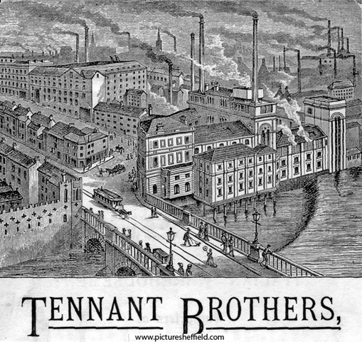
-
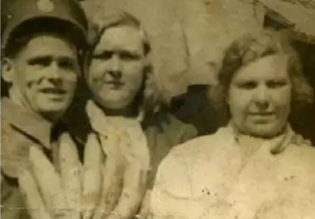
Does anyone remember the people in this photo? One is Big Ada from the old market on Dixon Lane Any memories of these people at all?
-
The original workhouse was situated in West Bar and was opened in 1733, hence Workhouse Lane, a remnant of which was still there in my memory. Basically right about where the roundabout is. Number 11 on the Gosling map. The Cotton Mill buildings (hence Cotton Street, Cotton Mill Row, and Cotton Mill Walk) were used as the Sheffield Union Workhouse from 1829 until 1881 (Fir Vale Workhouse opened). 18th June 1829 : The paupers having been removed from old workhouse to the new one, formerly the cotton mill, they were treated to 280lb of beef and 320lb of pudding; 317 paupers sat down. (Presumably the 600 pounds weight of food was meant for the lot of 'em, not each ) -------------------------- One for the people visiting The Fat Cat ... "map evidence suggests that the row of buildings backing onto Alma Street to the left of the current entrance to the Richardsons site (former Globe Steel Works) were not only part of the Workhouse, but also date back to the first cotton mill in 1805" Globe_Works.doc


-
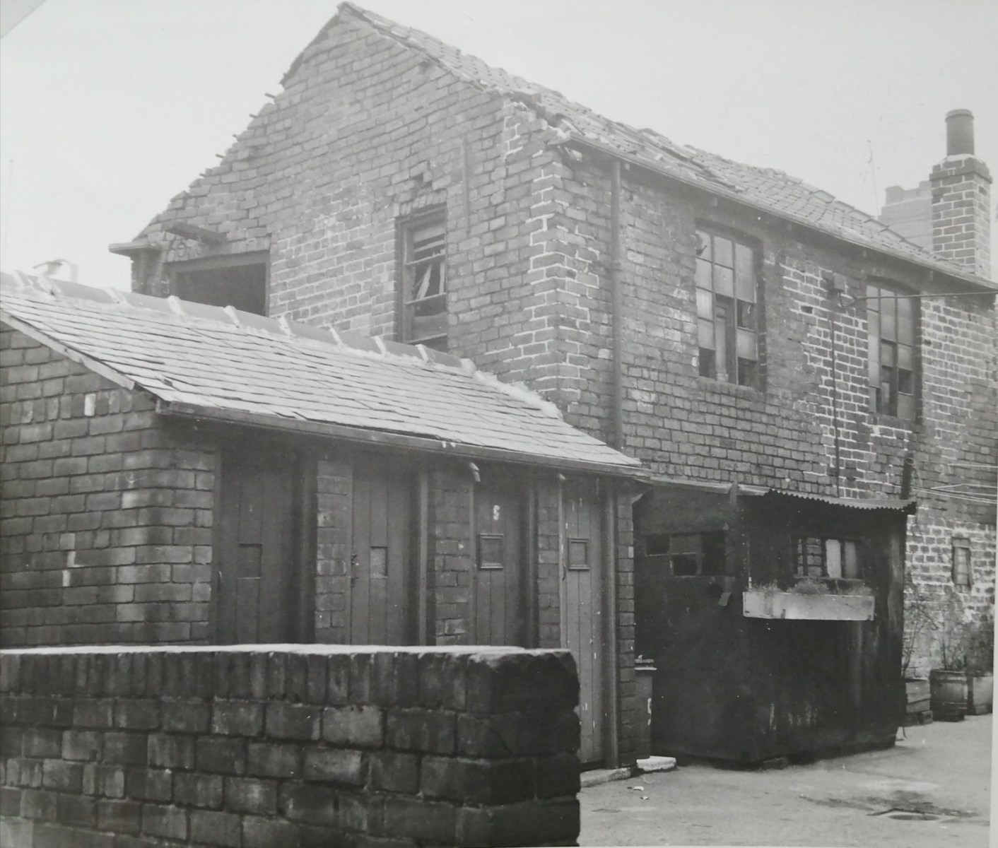
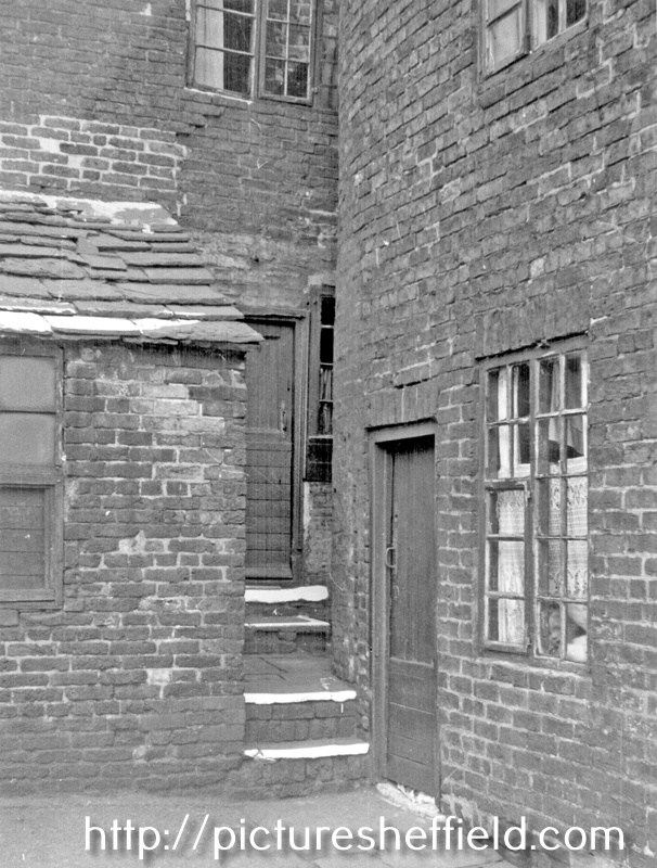
Hi does anyone have any information about a location known as Crooked Steps? It is shows as an ancestors address in the 1881 Census and listed as Harvest Lane. I've checked out Picture Sheffield but couldn't find any pics specifically listed as Crooked Steps. I know it was/is hilly around there so I'm guessing there literally were a set of crooked steps, it just seems odd to have as an address. Thanks in advance!
-
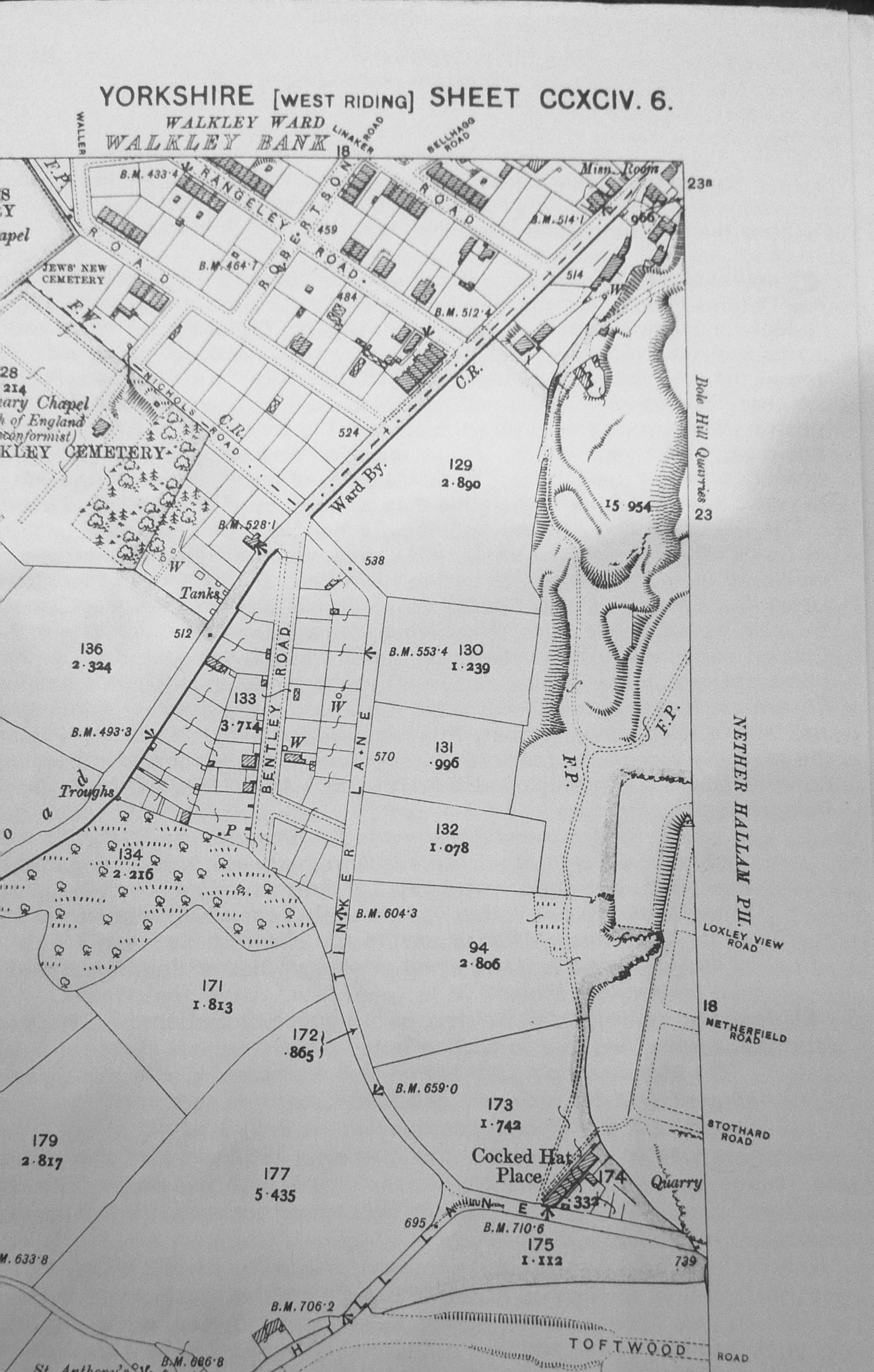
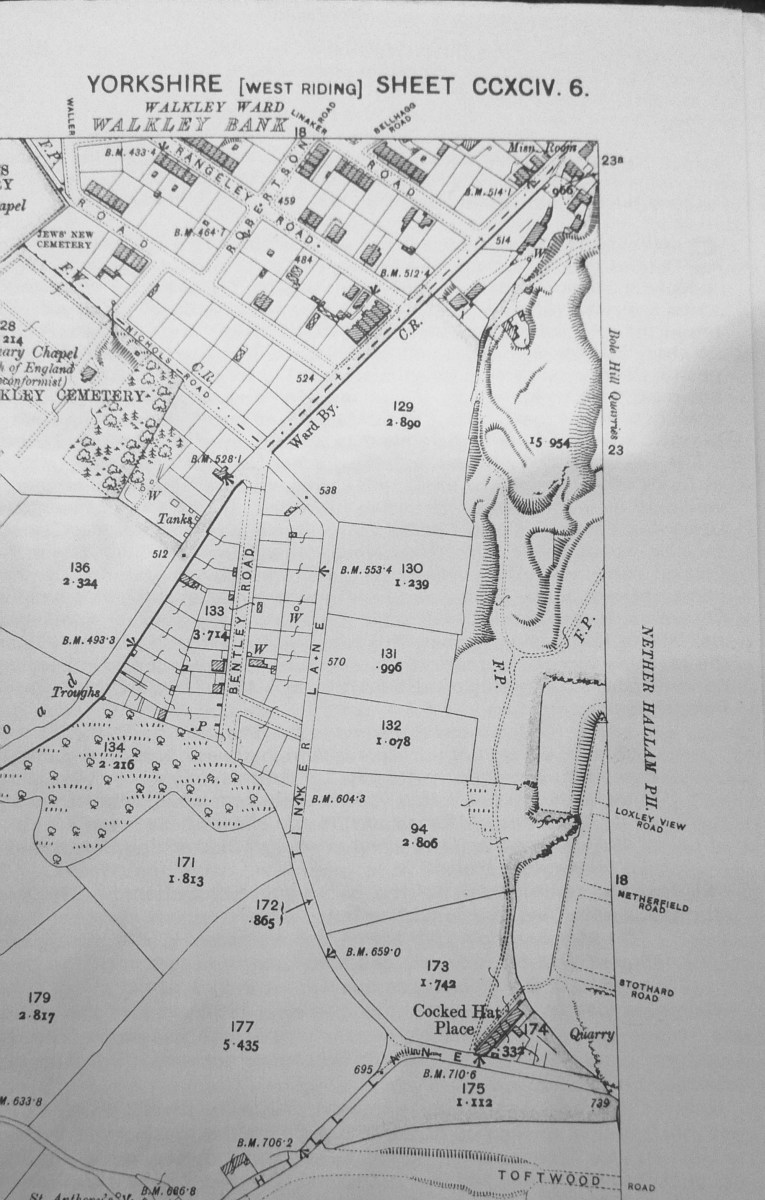
Preliminary Plan of the Walkley Land Society's Estate. 1877. https://www.picturesheffield.com/frontend.php?keywords=Ref_No_increment;EQUALS;arc06723&pos=6&action=zoom&id=105843 Shows Matlock Road, Walkley Road, Tinker Lane and Walkley Cemetery. Plan of the Upper Walkley Freehold Land Society's Estate. 1878. https://www.picturesheffield.com/frontend.php?keywords=Ref_No_increment;EQUALS;arc06724&pos=7&action=zoom&id=105844 Shows Bentley Road, Matlock Road, Walkley Road, Tinker Lane, Nicholls Road, Warren Road, Walkley Cemetery and Catholic Cemetery. Were the Allotments originally anything to do with the Walkley Land Society? ... These were plots for building on but they don't appear to have been built on by 1902 map. 1902 OS Map. 294.6.
-
I'm interested in Harmer Lane at the minute and finding information quite difficult to find. Does anyone know when the area was demolished? Any information would be gratefully received. Thank you
-
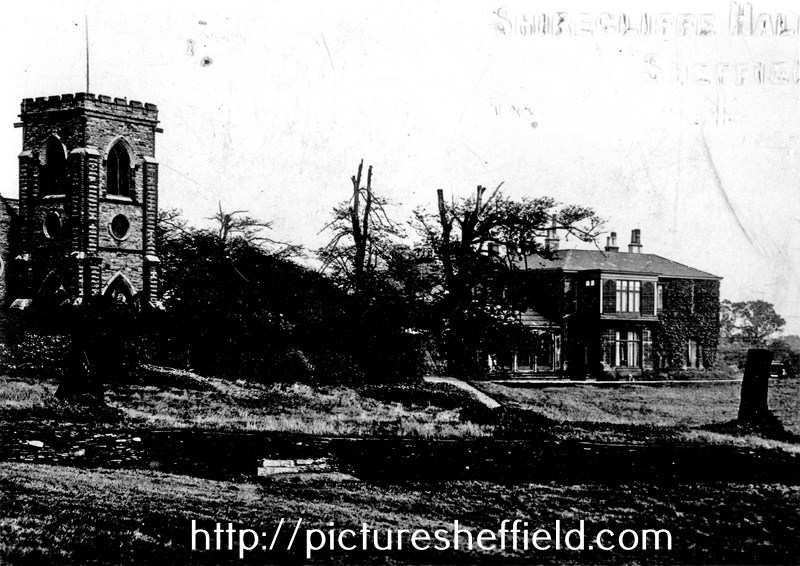
Link restored: Shirecliffe Hall, Shirecliffe Lane showing the Folly in the background. https://www.picturesheffield.com/frontend.php?keywords=Ref_No_increment;EQUALS;s05532&pos=50&action=zoom&id=8960 No Zoom. Shirecliffe Hall, Shirecliffe Lane with the Folly (left) u00508 Shirecliffe Hall and Cricket Ground. s03876
-
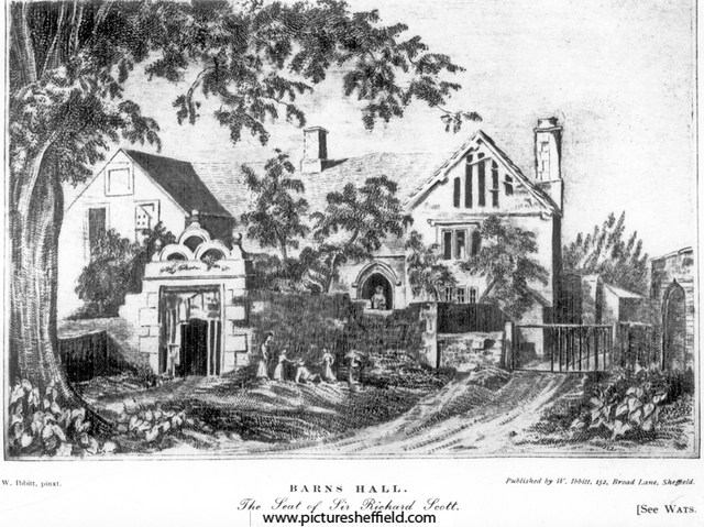
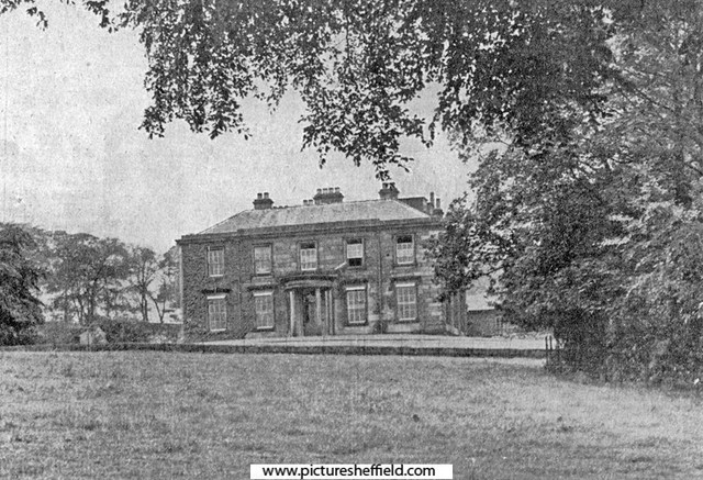
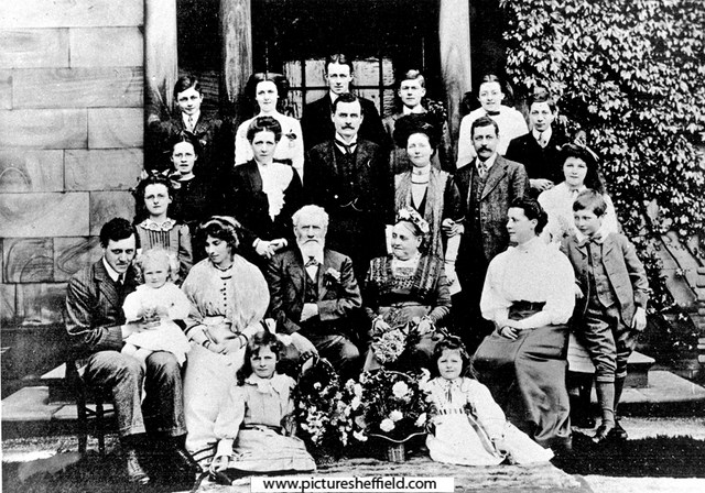
y01769 The first Barnes Hall, Chapeltown, Seat of Sir Richard Scott, prior to construction of present house which was built 1824 The family of Scott and Watts lived at Barnes Hall in the early 1500's, and it was inherited by a descendant, Henrietta Horton (1790-1827), who sold it to William Smith of Cowley Manor in 1823. He married Miss Parkin of Mortomley Hall, and rebuilt it in 1824. s05323 Barnes Hall, off Elliott Lane, Chapeltown. Built by William Smith The home of Col. W. Mackenzie Smith and Lady Mabel Smith https://www.picturesheffield.com/frontend.php?keywords=Ref_No_increment;EQUALS;s05715&pos=23&action=zoom&id=9128 https://www.picturesheffield.com/frontend.php?keywords=Ref_No_increment;EQUALS;v00781&pos=21&action=zoom&id=42584 Barnes Hall 5th May 1953 https://www.picturesheffield.com/frontend.php?keywords=Ref_No_increment;EQUALS;s05321&pos=4&action=zoom&id=8774 Stone inscription at Barnes Hall, off Elliott Lane, Chapeltown. Reads; 'As the hovre doth pas, so doth the life of man. His tearme is set and pas it no man can. Wisdome crieth at the gates at the entry of the city at the coming in at the dore.' https://www.picturesheffield.com/frontend.php?keywords=Ref_No_increment;EQUALS;y01760&pos=8&action=zoom&id=49233 The sundial overlooking the kitchen garden at Barnes Hall, off Elliott Lane, Chapeltown. The sundial was probably the work of Samuel Walker, who was engaged by Sir William Horton and bore the inscription 'DISCE DIES NUMERARARE TUOS.' 1738. Restored. Photograph dated 25th May 1957. https://www.picturesheffield.com/frontend.php?keywords=Ref_No_increment;EQUALS;y01758&pos=6&action=zoom&id=49231 https://www.picturesheffield.com/frontend.php?keywords=Ref_No_increment;EQUALS;y01759&pos=7&action=zoom&id=49232 Stable Block. https://www.picturesheffield.com/frontend.php?keywords=Ref_No_increment;EQUALS;y01762&pos=10&action=zoom&id=49235 Window dated 1825 and old gas lamp over the stable block doors at Barnes Hall, off Elliott Lane, Chapeltown https://www.picturesheffield.com/frontend.php?keywords=Ref_No_increment;EQUALS;y01761&pos=9&action=zoom&id=49234 Gardens of Barnes Hall. https://www.picturesheffield.com/frontend.php?keywords=Ref_No_increment;EQUALS;s09691&pos=24&action=zoom&id=12857 Barnes Hall Lodge, Elliott Lane. https://www.picturesheffield.com/frontend.php?keywords=Ref_No_increment;EQUALS;t01548&pos=20&action=zoom&id=32350 Barnes Hall Lodge, July 1989. https://www.picturesheffield.com/frontend.php?keywords=Ref_No_increment;EQUALS;s36798&pos=1&action=zoom&id=73115 s08943 Smith Family, believed to be taken at Barnes Hall, Chapeltown. y10574 Boer War: Lieutenant Stephen Alexander Smith, Imperial Yeomanry, the third son of Mr F. P. Smith, of Barnes Hall, and the grandson of the Late William Smith, and also of the venerable vicar of Ecclesfield, Dr Alfred Gatty. He had previously been in the Yorkshire Dragoons, and was one of the foremost to volunteer for the front. Smith was appointed as Lieutenant in the 11th Company, 3rd Battalion Imperial Yeomanry (Yorkshire Detachment) which left Liverpool in the Winifredian, on the 28th January, 1900. He was educated at Uppingham School: is a fine athlete, and has made himself very popular in local cricket circles. Image from Sheffield at the Front (page 42) (Printed and Published by The Sheffield Independent Press Limited). Ref: Sheffield Local Studies Library: 968.2 SF y10575 Boer War: Lieutenant Leonard Kirk Smith, Barnes Hall, Sheffield (Royal Scots). Smith is also the son of Mr F. P. Smith, of Barnes Hall. He holds a commission as 1st Lieutenant of the 2nd Battalion Royal Scots. When the Government decided to have mounted infantry in South Africa, he was selected, together with a number of men. He left England in the Cephalonia, on October 24th, 1899, and eventually joined General French's command. Took part in the operations around Colesberg and in the subsequent advances made by General French on Bloemfontein. His chief work has been scouting. He was very successful at Charterhouse and Sandhurst Schools, and is well known in the cricket field. He received his commission in 1897. Image from Sheffield at the Front (page 42) (Printed and Published by The Sheffield Independent Press Limited). Ref: Sheffield Local Studies Library: 968.2 SF
-
I cannot find evidence of drift mines or old pitheads but can north side of High Storrs RD
-
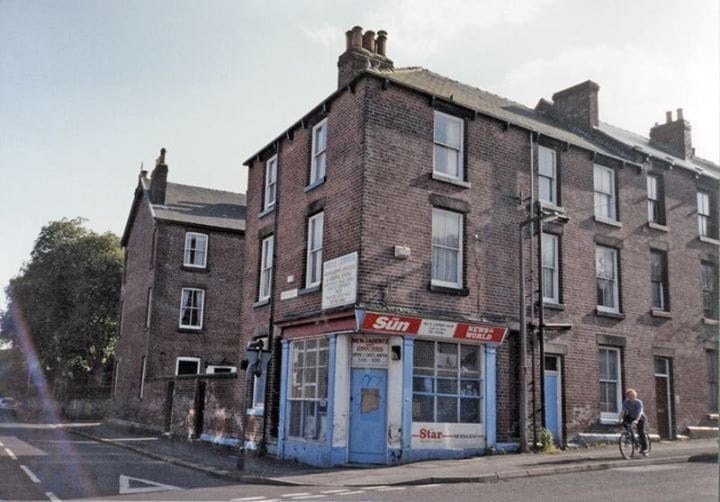
Does anyone remember this shop on the corner of Priory Road, and Sharrow Lane?
-

Tram - Origin of the Name?
Edmund replied to dunsbyowl1867's topic in Sheffield Buses, Trams and Trains
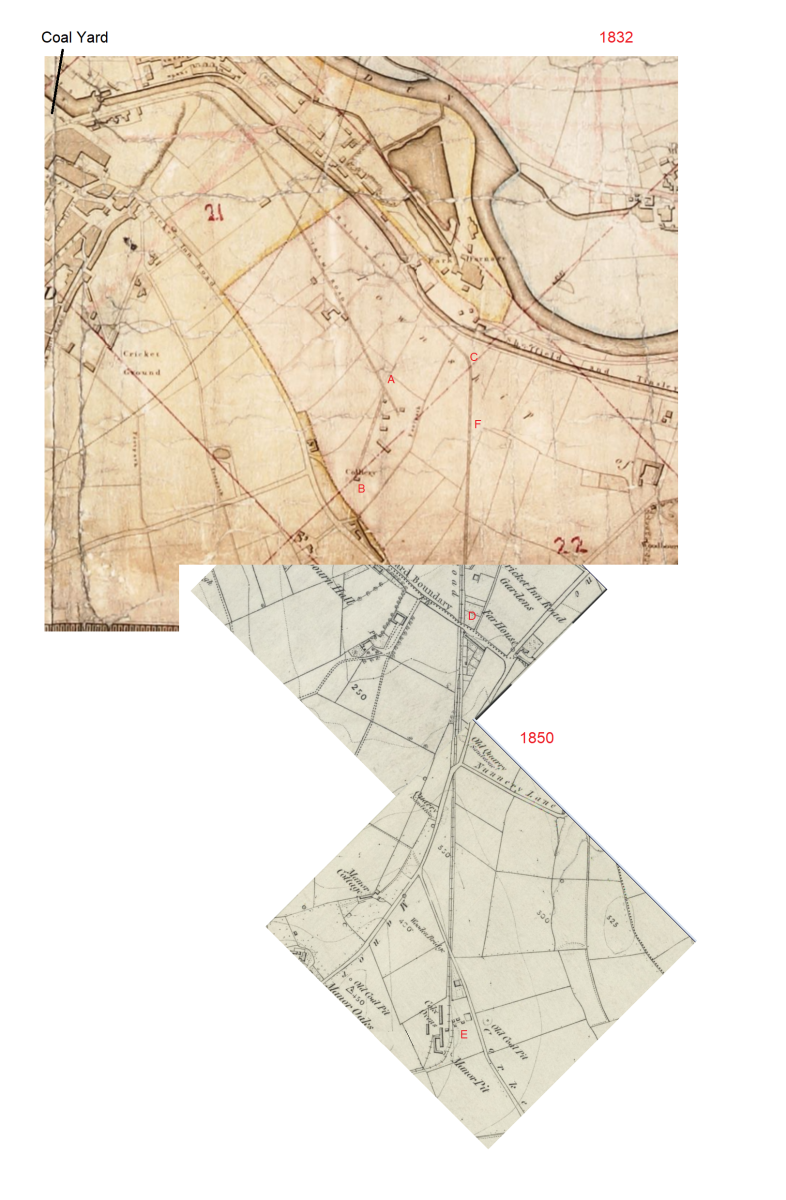
The engraving of the Sheaf Works deserves more credit for accuracy. It depicts the Works where they butt up to Maltravers Road, and even shows the weighbridge at the junction with the canal (as per 1:500 1890 plan). At far left is the work in progress Victoria Station Approach. The bridge carries the Manchester, Sheffield and Lincoln Railway. It does accurately depict the tramway running parallel and close to the canal (following Blast lane where it now passes under Derek Dooley Way). Presumably this section parallel to the canal had to be horse drawn as it was (obviously) flat - as opposed to sections where gravity might assist. Mostly for my own understanding of the situation, and I don't think it will add a great deal of new information, but here is a map I put together from 1832 (Tayler) and 1850 (OS) pieces. EDITED in RED: The tramway to the Sheffield Park Unidentified Colliery at B never crossed Cricket Inn Road as the pit was to the north of it. Heading out of Sheffield marked "Tram Road", at the Cricket Inn Engine House (now under South Yorks Police HQ car park, Point A on Tayler's 1832 map below) the tramway turned 45 degrees to the right and up to the Park Unidentified pit (now under Matalan's car park just south of the Parkway, B on Tayler's map). The tramway to the Manor Colliery (marked "rail way" on Taylor's map) split from the Park Unidentified Colliery tramway and continued parallel to the canal until it reached where Lumley Street is now, outside the Veolia plant (C on map) and turned 45 degrees to the right. It then headed in a straight line, first passing underneath the steam railway line (F on map, just north of the current Nunnery Square Supetram station), and crossing Cricket Inn Road (D on map,where now is the south east corner of the Storebox Self Storage compound (next to roundabout at junction of Cricket Inn Road / Woodbourn Road) then down to the Manor Pit (E on map) and the to the adjacent Manor Wood pit. The Cricket Inn Road Engine (point A) was at the top of a long downhill section and was fairly substantial with two boilers - possibly this Tram Road had mechanical assistance at some point in its history? Sheffield Archives have: Ref: ACM/MAPS/SheD/744L A Plan of the New Railway to the Manor Colliery showing the land taken by Messrs. Hounsfield Wilson and Co. from Sundry Tenants in order to make the same and for other purposes connected with the Colliery. The railway runs by the side of the canal for a short way, then crosses Cricket Inn Road and Manor Lane: fields affected by the railway included and tenants named and listed with acreages. Date c.1830 - does this mean that only the tramway to the Sheffield Park pit was built in the eighteenth century and not the route to the Manor Pit?

-
Hi, Have just joined this group. I am looking where I can find photographs of Water Lane, Sheffield. Around the period 1870-1890. Any assistance would be most welcome.
-
THE GRAND HOTEL LOCATION The Grand occupied all of the Fountain Precinct site opposite the bottom side of the City Hall, Orchard Lane and the part of Leopold St up to what now is the Yorkshire Building Society. It was Sheffield's most prestigious hotel. PICTURES advert from sheffield empire programme 1911 OWNERS The Russell Hotel Group in London STAFF Manager of the Grand - Frank Rendall (until 50's/60's) Head Porter - Les Gretton Head Waiter - 'Mister Bert' (Italian who had been interned on the Isle of Man in World War II) Head Receptionist - Miss Bogan Night Porter - 'Dennis' Wine Waiter - 'Leslie' FACTS The Grand Hotel was demolished in 1973 to make way for the Fountain Precinct. There was a house band at The Grand in the 60's Piano and leader: Winston Lee Tenor sax: Bunny Harrison Drums: Tony Oxley Trumpet: Ray Hollingsworth Bass: Len Stewart ? FAMOUS GUESTS Guests known to have stopped at The Grand include: Guy Mitchell Johnnie Ray Frankie Laine (singer) The Platters (musical group) The Harlem GlobeTrotters Frankie Lymon & The Teenagers David Whitfield Teddy Brown - (hugely overweight zxylophonist who topped the bill at the Empire Theatre during the war) Jimmy Young Lita Rosa Hilda Baker Pele (legendary footballer Brazilian football team Santos Lon Chaney (actor) Boris Karloff (actor) Wee Georgie Wood (old music-hall star) Frankie Howerd (comedian) Donald Peers (singer and radio show presenter) Larry Parkes & his wife Betty Garrett. http://www.imdb.com/name/nm0662972/ Larry played Al Jolson in The Al Jolson story and stayed at The Grand - they were appearing at the The Empire Theatre. They had a song and dance act together - which was really old hat and didn't go down very well, the theatre was half empty. He was apparantly in a terrible mood during the week he stayed. TRIVIA The hotel was 'the' place to stay in Sheffield and was very much a place for the stars to stop over when they had played the Sheffield venues. The lower ground floor was a gent's barbers - Barry was the name of the barber There was a ladies hairdressers upstairs, at the top of the wide staircase, which let to the rooms and the salon The Grand Hotel used plastic key rings which measured approximately 2"x4" that had a square for a postage stamp in case anyone forgot to leave their key when leaving. They could simply pop it in the postbox to be returned ! The Round Bar - up the stairs off Leopold St was one of the earliest hangouts of Sheffield's *** community During the war the Grand Hotel’s ‘Round Bar’ was on the left hand side of the hotel’s main entrance, and down a flight of steps. The hotel was much bigger than just the corner bar that came into being near Leopold Street. At the Balm Green end, opposite the City Hall, was an underground car park down the left handside and then two entrances through which cars/taxis could enter and leave (forecourt). Josephine's Night Club was later built on this site. The rear entance, had a revolving door and then steps down on to Leopold Street. John Spitzer, manager of the Empire could be spotted, frequently, exiting from that entrance. Football clubs either stayed at the Grand of the Royal Victoria. In the 60's they were virtually the only city centre hotels. Artistes appearing at the City Hall also stayed there as did cricket teams playing at Bramall Lane. There was an 'A' board that used to advertise the Winston Lee band. It was just inside those aforementioned revolving doors. The manager of the Sheffield Empire Theater during the fifties was Johnny Spitzer an enormous man. He lived at the Grand Hotel where he had a special deal. He used to have numerous large meals sent over from the hotel during the day and would sit in his office in front of the television set on his desk that was switched on all the time and eat them. The staff wondered what would happen if ever Val Parnell the managing director walked in. He did one day and the assistant manager went into the office to find both Val and Johnny sitting in front of the television and both eating enormous meals. There was an extensive wine list. Only one Italian, chianti in a straw flask, and a few German hocks. Bin 70 was 'Crown of Crowns', Bin 76 was 'Blue Nun', Bin 93 was 'Bernkasteler Estate' but as French wines were THE wines of the day the Grand had an excellent list, especially Premiere Cru chateau bottled Bordeaux, top Burgundy's etc. The Smoke Bar was at the top of some steps from Leopold St. This was run by a lady who also had a newagents at Highfields. She was the only female allowed there as it was foir 'Gentlemen Only'. This was full of characters including an ex Chelsea 'toff' who had a stall in Barnsley Market. Past the Smoke Bar were showcases for Swan & Edgar Further down on the right was the American Bar (the only cocktail bar in Sheffield!!) ran by 'Roland' who also had a newsagents down Heeley way Then there was a Dispense Bar, not open to the public but purely for service to the restaurant The 'high season' was October-March when events for 200 plus were staged most nights. All the Steel Works works had their annual and Christmas do's there as there was no other venue except the Victoria Hotel. When a new lift was installed an old medieval well was discovered in the cellar. It was promptly filled in and is located somewhere under the present car park ramp The draught beer sold at the Grand was Worthington E in 36 gall hogsheads delivered by British Rail directly from Burton. It had real hops in it and the ceiling of these cellars had a thick layer of these where the beer had 'worked' and squirted out the bung.


-
Tram - Origin of the Name?
Edmund replied to dunsbyowl1867's topic in Sheffield Buses, Trams and Trains
For reference, here's a timeline of coal related happenings in Sheffield: Timeline 1736 Gosling's Survey shows a Coal Yard 80 yards east of Shrewsbury Hospital 1737 John Bowden of Beighton leased pits at Sheffield, the Park, Attercliffe and Darnall Common from the Duke 1757 On the expiry of the Bowden lease the Duke took the Wood pits (Sheffield Park colliery) and Manor colliery back into direct management 1765 Duke leased Sheffield Park pits and Manor pits to Townsend and Furniss 1773 Estimate for timber waggonway prepared (probably by Curr) 1774 Wooden tramway laid down and destroyed 1775 Curr had cast-iron plates made to his own pattern by Outram, and placed on (apparently) wood running in the same direction - that is longitudinally 1777 Outrams design of flanged rails laid. Wooden transverse sleepers added, then cast iron boxes, then stone blocks 1779 Gander Lane Turnpike opened (Intake Road, now City Road) 1781 Duke takes collieries into direct management, Curr appointed Superintendent 1797 Publication of Curr's book "The Coal Viewer and Engine Builders' Practical Companion" 1801 Curr dismissed by Duke from Superintendent post 1805 Manor Colliery renamed as Woodthorpe Colliery 1819 Sheffield-Tinsley Canal opened, basin adjacent to coal yard 1823 February - Sheffield Colliery near canal basin opened 1830 George Stephenson report suggests a rail way from the canal basin to "Manor pit and beyond" -resulted in Jessop type flanged wheel rail way to Manor pit 1836 November - Deep Pit at Intake Road opened 1838 October - Sheffield & Rotherham Railway opened (first locomotive railway in Sheffield) -
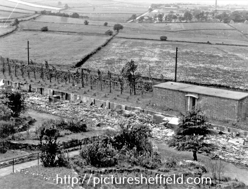
The photographs in earlier posts of housing due for demolition or in need of urgent repair you can see where donkey stoning the steps had been carried out. Even living in the shadow of the steelworks etc. and all the dirt and noise that was generated around them, they were still proud of their own home and kept it clean the best they could. Rear of No. 1 Wood Fold and back doorway of No. 175, Woodside Lane, 26th June 1957. demolished January 1960. s20695 It's unfortunate there isn't many photographs of interiors of the houses. Most of the photographs I've seen have been taken by the Council, Engineers & Surveyors Dept. or the Medical Officer of Health when reports have been needed to support the need for repair or demolition some through bomb damage but often through neglect by the Landlord. These photographs are often the only image there is of the house where they or their family lived. Sometimes only being able to say that space or the pile of bricks is all they have; or in my case the outside toilets of the neighbours. I only found that out because the City Engineers had written on the photograph identifying the derelict workshop they were attached to. From a map, discovered they were the outside toilets at the rear of Nos.1,3,5 & 7 Goulder Place, the houses were demolished some years before. "Goulder Place, workshop fronting Broughton Lane, taken 1st December 1962 by the City Engineers and Surveyors Office." The site is now part of Sheffield Arena Car Park. 1970, I took some photographs for a College project in the Carbrook area where my Grandmother had lived for a time. Demolition was well under way but there were some houses still occupied and even while demolition was going on around them, those steps were still being donkey stoned and the windows cleaned. Two ladies about their task thought I was from the Council but soon became friendlier when they discovered I wasn't. They hadn't wanted to move at first but were now looking forward to moving, and were missing their neighbours who'd already moved away.
-
This is the start of a new series of Then & Nows, based on a set of Tram photo's I have. Please post comments and memories as the topic progresses. 1. Brightside Lane 2. Norfolk Bridge 3. Penistone Rd / Langsett Rd Junction 4. Abbey Lane to Beauchief 5. Abbeydale Rd South 6. Abbeydale Rd 7. Wolsley Rd Heeley Bottom 8. Chesterfield Rd Woodsets 9. Kennings - Midland Station 10. Intake Terminus - Manor Top 11. Waingate, Blonk St, Wicker, Nursery St 12. Fitzalan Square 13. Neepsend 14. Furnival St - Brown St - Paternoster Row
-

The Tangerine Cafe on Leppings Lane
Sheffield History posted a topic in Sheffield Restaurants & Cafes
Does anyone know anything at all about The Tangerine Cafe on Leppings Lane? Anyone remember it? -
Booth & Co., Park Iron Works, Brightside Forge & Royds Mill.
Ponytail replied to Ponytail's topic in Made In Sheffield
Plan of Salmon Pastures held of the Duke of Norfolk by Thos. Sambourne. 1792. Surveyor: William Fairbank II. https://www.picturesheffield.com/frontend.php?keywords=Ref_No_increment;EQUALS;arc02669&pos=7&action=zoom&id=91474 Shows part of the River Don, and the Goight and Foundry; (Warren Street, Royds Mill and Farm.) fields etc. lettered and listed with particulars: a. Proposed to be taken on lease for 99 years. b. Proposed to be given up to the Road. c. Lower Salmon Pastures, as proposed to be altered. d. Held by Booth & Co., part of the Netherfield. e. Island. f. Upper Salmon Pastures. g. Lower part. h. Upper part, proposed to be kept for sand. Held by John Booth & Co. A map of Salmon Pastures held of the Duke of Norfolk by Wm. and Geo. Binks.1787. Surveyor: William Fairbank II. https://www.picturesheffield.com/frontend.php?keywords=Ref_No_increment;EQUALS;arc02667&pos=5&action=zoom&id=91471 Between (Warren Street) and the goight and the Don; closes, etc., numbered and listed with particulars. Includes the Nether Field and the old wheel; numerical list with acreages; field names given on the map. (Royds Mill and Farm.) It's probable that Burton took over the Mill before 1720. 1718/19, Burton Dam appears in the Repair account. 1737 William Burton took a 21 year lease of "corn mill called Attercliffe Mill near Washford Bridge" 1756 lease still in the name of Burton, 1761 the property listed in his will. 1765, Hartop, ironmasters had a 21year lease; 1782, Binks, Booth and Hartop, the lease recording the poor condition of Royds Mill and Wheel and measures needed by the new tenants to rebuild it and improve the water supply. 1794, Booth & Co. recorded at Royds Mill & Wheel. The partnership were at this time on the south side of the River Don, developing the Park Ironworks. 1821, Royds Works advertised for sale or let by Auction described as a Corn Mill; Forge and Rolling Mill. A Map of the Turnpike Road from Westforde [Washford] Bridge to the Mill Goite, c.1760-1770. Surveyor: John Needham. https://www.picturesheffield.com/frontend.php?keywords=Ref_No_increment;EQUALS;arc02665&pos=4&action=zoom&id=91373 Outline of the mill wheel and goit; 'measurement of land required to make the road straight.' (Royd's Mill Street) Marked: Mr. Burton Lane. River Dun (Don); Weste Ford Bridge (Washford) (Royds Mill and Farm. Windsor Street.) For more information about Royds Mill and Wheel, see "Water Power on the Sheffield Rivers" , edited by David Crossley with Jean Cass, Neville Flavell & Colin Turner. -
Mower & Pearson, Brewers, Wine and Spirit Merchants, Scotland Street & Pea Croft
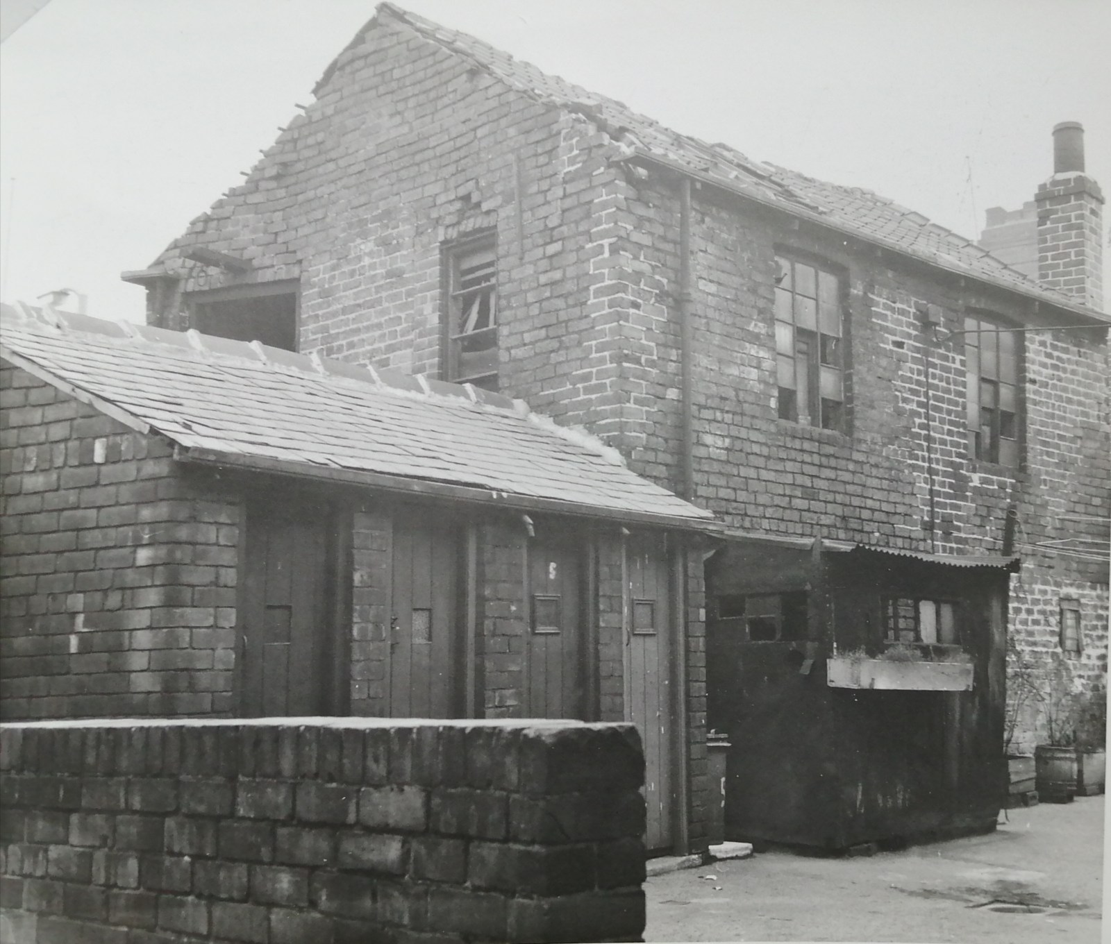
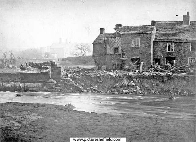
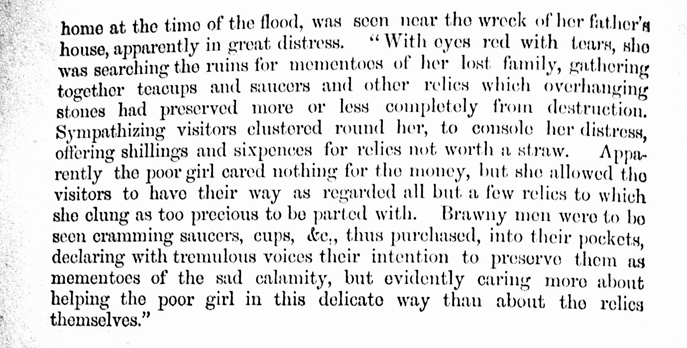
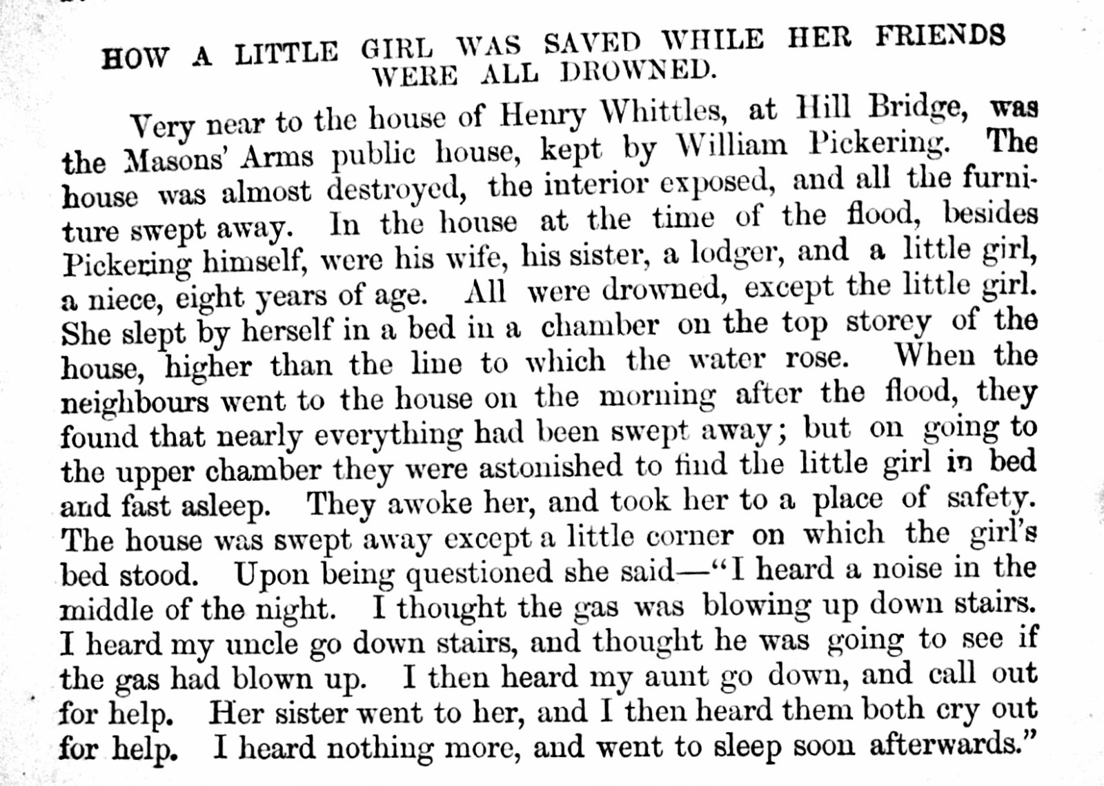
Ponytail replied to Ponytail's topic in Sheffield Pubs and WMC's
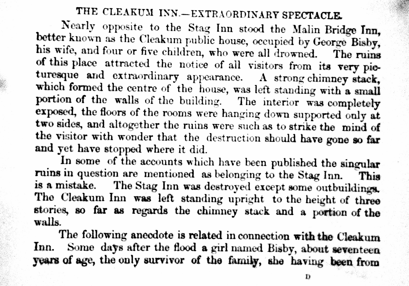
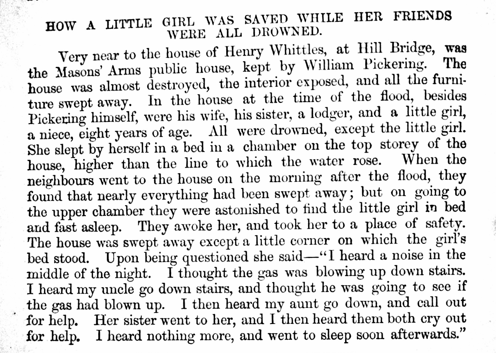
Sheffield Flood Claim: Nathaniel James Fewsdale Mower, wine merchant, Scotland Street Public House called Malin Bridge Inn, occupied by Mr. Bisby with Stabling, Outbuildings and Conveniences completely destroyed. https://sheffieldfloodclaimsarchive.shu.ac.uk/claimSummary.cfm?claim=7-5915 Picture Sheffield s00584 Artist, Drury, Malin Bridge Inn also known as Cleakum Inn. https://www.picturesheffield.com/frontend.php?keywords=Ref_No_increment;EQUALS;s00606&pos=10&action=zoom&id=4507 Nathaniel James Fewsdale Mower and Henry William Pearson, wine merchants and brewers, Scotland Street To Furniture and Effects in Public House called Malin Bridge utterly lost. Tennant, Mr. Bisby. To Casks and Bottles lost and destroyed in the possession of various Customers to whom they had been lent until empty: William Pickering, Hillsbro'. George Bisby, Malin Bridge Inn. Alfred Hinchliffe, Orchard Lane, Harvest Lane. William Hawksley, Bower Spring. Charles Price, Malin Bridge Hobson Peace, Owlerton Road. James Hewitt, Hillfoot. Mrs. Harper, Shalesmoor. Frederick Shaw, Damflask. William Robinson, Orchard Lane, Harvest Lane. George Greaves, Wicker. William Heppenstall, Corporation Street. Thomas, Sykes, Royal Oak, Saville Street. John Pilling, Princess Street. John Stringer, "Ball" Green Lane. Francis Todd, Iron Bridge. Mrs. Rowe, Saville Street. Charles Stainforth, Green Lane. John Frith, "Cup" Dun Street. William Riley, Neepsend Lane. G. F. Gardener, Neepsend Brewery. Edward Parkin, Spring Street. Samuel Alvey, Harvest Lane. https://sheffieldfloodclaimsarchive.shu.ac.uk/claimSummary.cfm?claim=7-6136 Sheffield Flood Claims: Personal Claims for licencees who Mower & Pearson had claimed for the Casks and Bottles "lent" William Pickering, claim by Mower & Pearson names him of Hillsbro'. Pickering was licensee of the Free Masons Arms, Hill Bridge. s00969 Remains of Hill Bridge and Free Masons Arms, junction of Limbrick Lane right. From "History of the Flood at Sheffield" Claim for deceased William Pickering and others at the Freemason Arms https://sheffieldfloodclaimsarchive.shu.ac.uk/claimSummary.cfm?claim=9a-59 https://sheffieldfloodclaimsarchive.shu.ac.uk/claimSummary.cfm?claim=9a-58 https://sheffieldfloodclaimsarchive.shu.ac.uk/claimSummary.cfm?claim=5-4376 Property lost at the Freemason Arms. https://sheffieldfloodclaimsarchive.shu.ac.uk/claimSummary.cfm?claim=5-4385 George Bisby, carter and Innkeeper, Malin Bridge. Died. Funeral expence, maintenance of daughter, Emma. Estate and Effects. https://sheffieldfloodclaimsarchive.shu.ac.uk/claimSummary.cfm?claim=3-2756 From "History of the Flood at Sheffield" Alfred Hinchliffe, grocer, 9 Orchard Street, Harvest Lane. https://sheffieldfloodclaimsarchive.shu.ac.uk/claimSummary.cfm?claim=10-53 William Hawksley, Bower Spring. Probably, Ann Hawksley, widow and publican, Rifle Tavern, Bower Street. https://sheffieldfloodclaimsarchive.shu.ac.uk/claimSummary.cfm?claim=5-4633 Ann Hawksley claimed for illness caused by the Flood for herself and daughter https://sheffieldfloodclaimsarchive.shu.ac.uk/claimSummary.cfm?claim=9b-169 Charles Price, Malin Bridge ?? Hobson Peace, Owlerton Road (Probably William Hobson Peace, Silver & Metal Roller, Old Park Mills. https://sheffieldfloodclaimsarchive.shu.ac.uk/claimSummary.cfm?claim=8-6397 Also claimed Montague George Burgoyne Esq, Eaton Sq. for a number of lands & properties (total 22) including (no.19) Old Park Rolling Mills, house, land, cottages and Premises. https://sheffieldfloodclaimsarchive.shu.ac.uk/claimSummary.cfm?claim=7-5975 James Hewitt, Hillfoot ?? Mrs Harriet Harper, widow and publican, Lucknow Tavern Shalesmoor. https://sheffieldfloodclaimsarchive.shu.ac.uk/claimSummary.cfm?claim=5-4353 Frederick Shaw, Damflask. ?? William Robinson, labourer, back of Number 47 Harvest Lane. https://sheffieldfloodclaimsarchive.shu.ac.uk/claimSummary.cfm?claim=6-5319 George Greaves, Brown Cow Inn, 56 Wicker. https://sheffieldfloodclaimsarchive.shu.ac.uk/claimSummary.cfm?claim=6-5117 Brown Cow building owned by William Unwin (Richard Trustwell & Co) https://sheffieldfloodclaimsarchive.shu.ac.uk/claimSummary.cfm?claim=6-5423 William Heppenstall, innkeeper, Corporation Inn, Corporation Street. https://sheffieldfloodclaimsarchive.shu.ac.uk/claimSummary.cfm?claim=4-4101 Thomas Sykes, publican and file cutter, Saville Street. (Mower & Pearson claim, name it as the Royal Oak) https://sheffieldfloodclaimsarchive.shu.ac.uk/claimSummary.cfm?claim=5-4564 John Pilling, beerhouse keeper (unnamed) and coal dealer, Princess Street, Attercliffe Road. https://sheffieldfloodclaimsarchive.shu.ac.uk/claimSummary.cfm?claim=4-4181 John Stringer, innkeeper, The Ball, 84 Green Lane. Claiming for loss of businessas as Ball Street Bridge washed away. https://sheffieldfloodclaimsarchive.shu.ac.uk/claimSummary.cfm?claim=4-3966 Personal property listed then claim withdrawn. https://sheffieldfloodclaimsarchive.shu.ac.uk/claimSummary.cfm?claim=7-5956 Francis Todd, publican, Forresters Arms, Ironbridge. https://sheffieldfloodclaimsarchive.shu.ac.uk/claimSummary.cfm?claim=7-5922 https://sheffieldfloodclaimsarchive.shu.ac.uk/claimSummary.cfm?claim=4-4259 Mrs Mary Rowe, widow Inn keeper, Atlas Inn, Saville Street. https://sheffieldfloodclaimsarchive.shu.ac.uk/notFound.cfm?claim=4-4039 Charles Stainforth, beerhouse keeper, Hallamshire Hotel, Green Lane https://sheffieldfloodclaimsarchive.shu.ac.uk/claimSummary.cfm?claim=4-3801 Claim for Harriet Rodgers at Charles Stainforth at 74, Green Lane. https://sheffieldfloodclaimsarchive.shu.ac.uk/claimSummary.cfm?claim=9b-309 John Frith, publican, The Cup, Dun Street (as tennant to Mr. Edward Hoyland) https://sheffieldfloodclaimsarchive.shu.ac.uk/claimSummary.cfm?claim=4-3449 William Riley, beerhouse keeper and green grocer, Mill Houses (Mills Property) Neepsend Lane. Recorded as both. https://sheffieldfloodclaimsarchive.shu.ac.uk/claimSummary.cfm?claim=1-989 George Frederick Gardener, brewer, Neepsend Brewery Of Westbar late of Neepsend https://sheffieldfloodclaimsarchive.shu.ac.uk/claimSummary.cfm?claim=7-5961 Edwin (recorded as Edward in Mower & Pearson claim) Parkin, publican (House not named) Spring Street. https://sheffieldfloodclaimsarchive.shu.ac.uk/claimSummary.cfm?claim=1-294 Samuel Alvey, publican, Saw Makers Arms, Neepsend Lane (Mower and Pearson Claim records Harvest Lane) https://sheffieldfloodclaimsarchive.shu.ac.uk/claimSummary.cfm?claim=4-3886

-
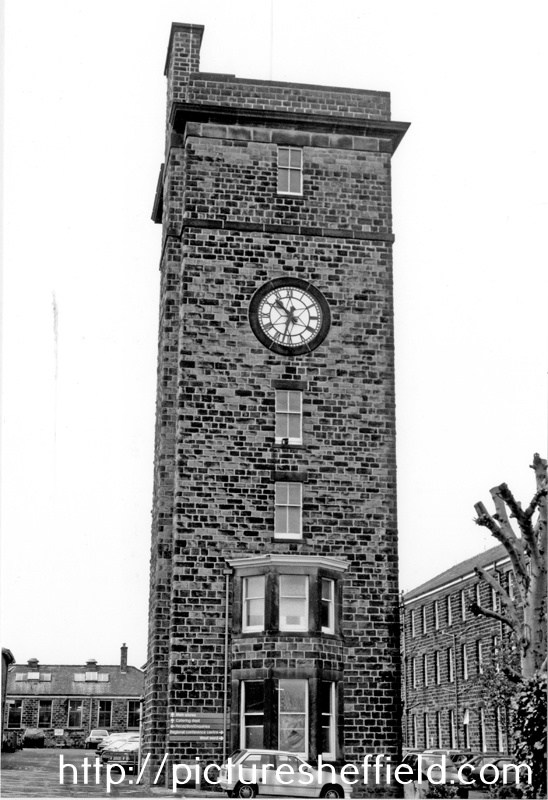
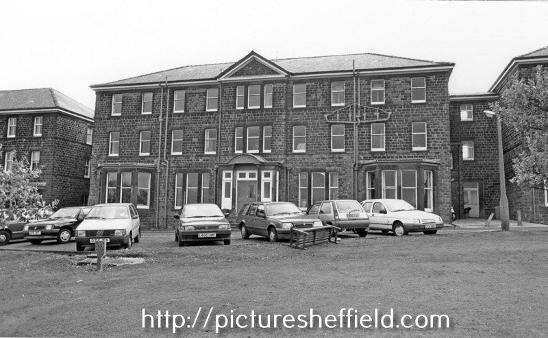
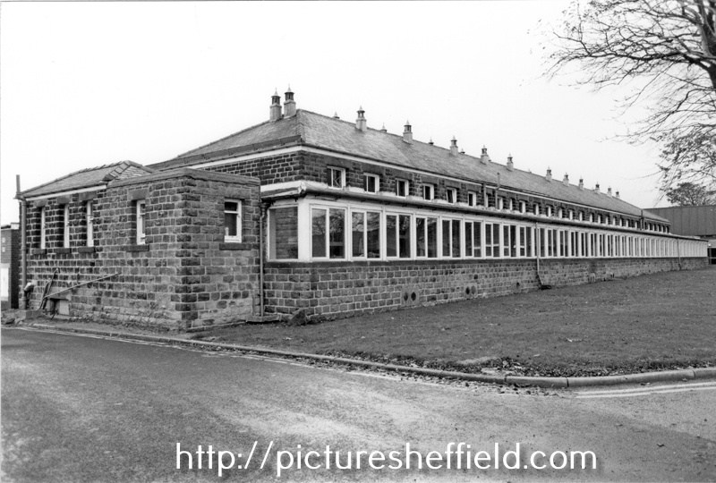
Lodge Moor Hospital was originally built in 1887, opening its 12 wooden wards on the 20th February 1888 as the Borough Smallpox Hospital. Demolition of Tuberculosis Huts, Crimicar Lane. 1955. s23386 s21093 View taken from an upstairs room of the main Crimicar Lane Isolation Hospital showing the WW2 concrete roofed air raid shelter. By June 1898 it was decided to add permanant stone buildings to comprise of accommodation for 146 patients. The administation block and isolation wards were occupied in 1901 and 6 wards each with 22 beds were completed by 1902. The Clock Tower and the Lodge at the main gates were completed in May 1903. For more information see: Lodge Moor Hospital 1887-1987, Lodge Moor Cenenary Brochure Ref: 362.11. See also The Hospital on the Moor, the spinal injuries unit Lodge Moor by Ella Goddard Ref: 362.197482. Clock Tower, Main Entrance, Lodge Moor Hospital. 30th October 1990. s23347 Administration Block, Lodge Moor Hospital. s23355 Infectious Diseases Wards (West Wards), Lodge Moor Hospitals23354 Respiratory Function Unit, Lodge Moor Hospital. s23353
-
History of Attercliffe and the Benjamin Huntsman steelworks
Ponytail replied to a topic in Sheffield History Chat
A Plan of two Closes, Buildings, etc. held under the Duke of Norfolk by Samuel Scholey and W. Scrapper. 1763. https://www.picturesheffield.com/frontend.php?keywords=Ref_No_increment;EQUALS;arc02680&pos=75&action=zoom&id=91520 Surveyor: William Fairbank II. This is one of the enclosed strips south-west of Worksop Road; acreages listed; explanation of the buildings. Marked: Close in Saml Scholey's possesion. Close in W. Rapper's possesion. Included in the next strip: B. Huntsman's Furnace; a. Part of Benjamin Huntsman's Yard; b. A shed erected by him; c. Part of a Mill House built by him; d. A piece of Ground proposed to be taken by him for enlarging his Works; e. g. Buildings; f. a Yard; h. h. i. Gardens, held by William Crapper. k. Another part proposed to be taken by Benjamin Huntsman for enlarging his works. the etc. in the next strip. Also marked: Lands vested in the Capitol Burgesses of Sheffied; Attercliffe Green; (Attercliffe Steel Furnace, Worksop Road, Shirland Lane.) -
Suggestion as to the origin of the name Jehu Lane. This one as recounted in Reminiscences of Old Sheffield, it's streets and it's people. From the 1870's Pages 213 & 214. "Leonard : Do you know what is said to be the origin of the name Jehu lane ? The tradition is, that when Mary Queen of Scots arrived in Sheffield for imprisonment at the Manor, this lane was the main road, and through it she had to pass. The streets had not been planned in expectation of such things as coaches rolling through them, and the lane astonished the Queen's coachman to such an extent that he ejaculated "Jehu!" — by way, I suppose, of invoking the tutelary genius of drivers in his difficulty. Everard : Credat Judcsus !" From a Google Search Originally a commander of chariots for Ahab, king of Israel, Jehu later led a revolt against the throne and became king himself. In the Bible, it is noted of Jehu that "he drives furiously" (II Kings 9:20). In the 17th century, English speakers began using jehu as a generic term meaning "coachman" or, specifically, "a fast or reckless coachman." Today, we are more likely to use the word in reference to reckless cabdrivers. The phrase drives like Jehu is encountered occasionally, too.
-
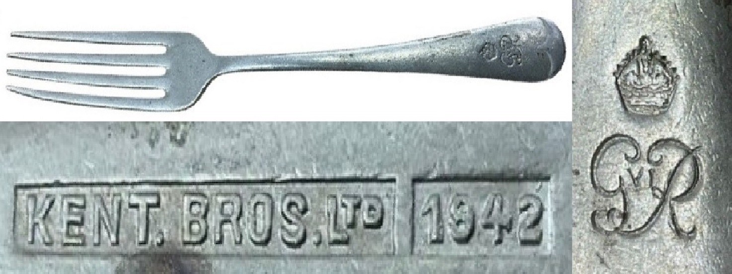
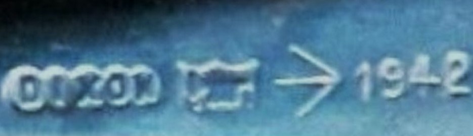
Hello, again I'm back at one of my previous posts. A belated thank you also to Loubaruch for your insightful contribution to the Bennett & Heron history. I am back though because of the mention of Kent Brothers (possibly not mentioned elsewhere on the Forum), a concern I had not come across until I saw online a suggested, military dining fork with a date on it, and indicated to have been made by that firm. The suggestion of the fork being military was no doubt because of the Royal cypher of King George VI shown its finial. There also is Kent Brothers Ltd and 1942. There is a full history of “Kent Bros” on the "Hawley’s Name on a Knife Blade" site but in brief they were formed in 1919 by brothers Percy & Leonard Kent on Broad Lane and “Ltd” in 1922 at 168 Broad Lane. Apparently wound up in 1969, when the chairman was E. H. Beighton. That was the surname Loubaruch quoted in his “B&H” history addition to this post. Other information was that B&H “bought out another manufacturer Kent Brothers who had a larger factory in Broad Lane, B&H then moved to Broad Lane in about 1960“. Is it coincidental that the name “Beighton” and the Broad Lane address are referenced with both companies? Were both companies run concurrently for a while or were B&H using the “Kent Bros” mark? Regarding the fork I am not sure it is necessarily for military use. Although the wartime date of 1942 was in King George VI’s reign the fork does not carry the “/|\” broad arrow mark associated with Government order items and typically seen on military stuff, including cutlery. A James Dixon & Sons example from 1942 with the “/|\” is below. I think there were other organisations that would have been using the King George VI cypher on cutlery. I think the General Post Office (GPO) would have been my top possibility. Any other suggestions? Kalfred