Search the Community
Showing results for 'coal pit lane'.
-
Interestingly the Dyson brothers, Joseph and James crossed the paths of history in later life - in 1864 thanks to the Sheffield flood. The 2 brothers hailed from Thurgoland and in 1864 they were both employed at a wireworks on Bradfield Road, Hillsborough. Joseph (the manager there) and his family lived in Brick Row, Holme Lane where James lodged during the week while his family lived in Thurgoland. On the night of Friday March 10 / 11 the Dale Dike dam at Bradfield burst and the flood killed over 200 people in the Sheffield area. The flood destroyed Brick Row and Joseph and most of his family were killed - one child was away that night and survived - but James escaped by breaking through the roof and he escaped and was reunited with his own family a couple of days later - his wife had come by train to Sheffield to try and find him and he caught the train back home! My partner is James’s g-g-granddaughter and every time we go into the Norfolk Arms we think of him, his relatives and their experiences of that terrible night.
-
Link to: Brightside Lane Houses. https://www.sheffieldhistory.co.uk/forums/topic/18229-brightside-lane-houses/
-
The Steam Clock public house, Brightside Lane. Sheffield Flood Claim: William Butcher, William Fisher and Thomas Edward Mycock, Trustees of the Sheffield & South Yorkshire Permanent Building and Investment Society, Care of Alfred Allott, Prior Court, Sheffield. For damage to 10 Houses & 2 Houses & Shops situate adjoining a Public House known as "The Steam Clock" in Brightside Lane, nr. Sheffield. https://sheffieldfloodclaimsarchive.shu.ac.uk/claimSummary.cfm?claim=7-5680
-
Butchers shown is number 147, the 1965 directory lists that whole building as S&E Co op Ltd., (no street number) the house to the left in the photograph, is number 141 Bocking Lane. Something has changed?
-
Judging by this previous thread on SH about Co-Op’s, the Bocking Lane branch doesn’t look anything like the photo???
-
Thank you very much Stenner, I don't know the area at all and other photographs aren't helping to confirm. Does anybody have any photographs of the shops on Bocking Lane? Or can see what it is over the doorway? I only have a mobile phone to work with.
-
This looks very much like the S&E Coop that was in Greenhill village, top of Bocking Lane just before the roundabout - I used to live on Lowedges at that time and for a short time went to the school on the other section of the roundabout (the school on Lowedges Road hadn't been finished at the time - that must have been about 1954/5)
-
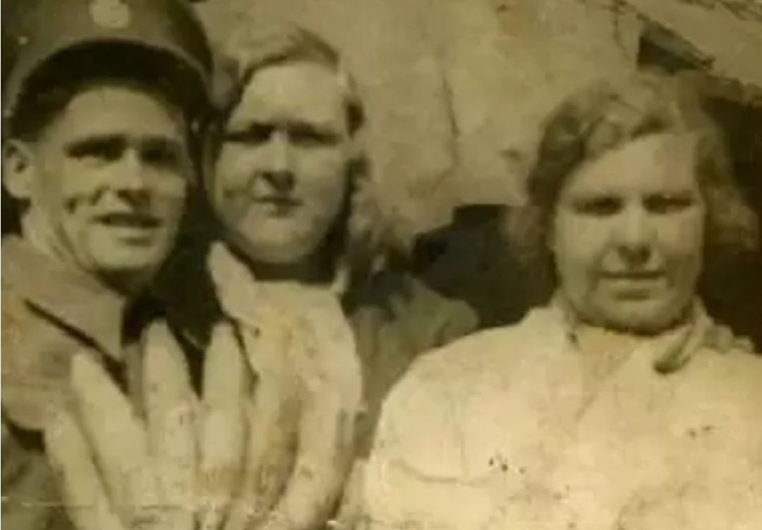
Does anyone remember the people in this photo? One is Big Ada from the old market on Dixon Lane Any memories of these people at all?
-
Hi does anyone have any information about a location known as Crooked Steps? It is shows as an ancestors address in the 1881 Census and listed as Harvest Lane. I've checked out Picture Sheffield but couldn't find any pics specifically listed as Crooked Steps. I know it was/is hilly around there so I'm guessing there literally were a set of crooked steps, it just seems odd to have as an address. Thanks in advance!
-

Old Sheffield tram routes - bit of confusion !
Roger Stevenson posted a topic in Sheffield History Chat
Out walking yesterday ( Tues 20 Feb ) I noticed in the footpath on Cemetery Road at Sharrow Head, the junction of Psalter Lane and Sharrow Vale Road, the service box shown in the attached photo. as far as I am aware and I have just looked at a map of the old tram network on the web, the trams didn't run up Cemetery Road to the top, but turned at the Washington Road junction to proceed to Nether Edge. What's the reason for that box outside 309 Cemetery Road ? I'm intrigued, may be a straightforward answer.
-
The lot which became "Foresters" is shown at the junction of Division Street and Rockingham Street labelled boldly in capital letters as William Smith then underneath written "now John Green" Plan of certain building land the property of Messrs Brittain, Wilkinson and Brownell. 1829. https://www.picturesheffield.com/frontend.php?keywords=Ref_No_increment;EQUALS;arc04097&pos=14&action=zoom&id=103534 Shows Rockingham Street, Division Street, Rockingham Lane and Carver Street. Also, owners or tenants: John Harrop, Henry Blackwell; Charles Brown; William Smith; Jacob Bridge; John, Joseph, William and Edwin Mouslon. Steel furnaces, cutlers shops and warehouse marked. Surveyed and drawn by J. Fairbank and Son. Premise of William Smith also marked Jacob Bridge Plan of vacant land, the property of Verdon Brittain, Robert Robinson Brownell and Charles Brownell. 1829. https://www.picturesheffield.com/frontend.php?keywords=Ref_No_increment;EQUALS;arc04096&pos=13&action=zoom&id=103533 Shows Rockingham Street, Division Street, Rockingham Lane and Carver Street. Property leased to John Harrop, property leased to Henry Blackwell; also, owners or tenants: Charles Brown; William Smith; Jacob Bridge; John, Joseph, William and Edwin Mouslon. Forester's Inn marked right hand side towards the top. Ordnance Survey Map, sheet no. Yorkshire No. 294.7.25. 1889 https://www.picturesheffield.com/frontend.php?keywords=Ref_No_increment;EQUALS;q00075&pos=2&action=zoom&id=107161 Sheffield History A-Z Public Houses List. Forester's Inn/Yorick/The Yorl/Olive Bar, 57 Division Street Open 1828. 1828 William Smith 1833 William Smith 1834 William Smith 1837 Jacob Bridge 1839 W Deakin 1841 John Parsons [Pigot's ] 149 Rockingham Street 1841 William Richmond [ Whites ] 1845 Charles Holland (149 Rockingham Street) 1846 Charles Holland 1849 George Skinner 1852 George Skinner [57 Division Street] 1854 George Skinner 1856 George Skinner 1859 Herbert Rowe 1862 John Storey 1863 John Storey 1864 John Storey [57 Division Street] 1865 John Storey 1868 Thomas Webster 1871 Thomas Webster 1876 Thomas Webster [73-5 Division Street] 1879 William Thompson 1881 William Thompson [73 Division St] 1883 John Maxfield 1887 to 1890 John Maxfield 1893 John Maxfield 1895/6 Herbert Bevington 1898 Herbert Bevington 1900 to 1902 Herbert Bevington 1903 William Charles Lockwood 1905 William Charles Lockwood 1907 Mrs Eliza Smith 1910 to 1913 Frank Shelton 1916 Frank Shelton 1917 Frank Shelton 1919/20 Frank Shelton 1921 Herbert Walker 1922 Herbert Walker 1923 Sidney Hudson 1924 Gorden Lyall 1925 Gordon Lyall 1929 Gorden Lyall 1931 Harry Rose 1932 Mrs Sarah Agnes A Thomas 1933 Mrs Sarah Agnes A Thomas 1936 to 1939 Frank Jones 1942 Frank Jones 1944 Frank Jones 1948 Frank Lee (73-75 Division Street)
-
I'd read of "Paddy's Goose" then immediately forgotten where I'd read it, so it is very pleasing to bring a keeper of : Paddy's Goose Love Lane, Sheffield Henry Greenwood (any location for Love Lane ? is/was it near the Queens in Pond Street ?)
-
I'm interested in Harmer Lane at the minute and finding information quite difficult to find. Does anyone know when the area was demolished? Any information would be gratefully received. Thank you
-
Cross Inn, Woodfall Lane, Low Bradfield, closed about 1980. https://www.picturesheffield.com/frontend.php?keywords=Ref_No_increment;EQUALS;s29646&pos=92&action=zoom&id=56159 Cottages at Low Bradfield which were originally the Cross Inn, Woodfall Lane. 4th September 1986.s29621 Low Bradfield. Cottages in the centre were orginally the Cross Inn. 4th September 1986. s29631
-
What does "main" mean in a colliery name ?
Ponytail replied to JS2021's topic in Sheffield History Chat
As discussed the first pit sunk in the town was often called Main. Never considered it before, was there ever a Sheffield Main Colliery? Sheffield Collieries at Work 1869. https://www.chrishobbs.com/sheffield/1869shefpits.htm https://en.m.wikipedia.org/wiki/Sheffield_Coal_Company -
What does "main" mean in a colliery name ?
Ponytail replied to JS2021's topic in Sheffield History Chat
Referring to Maltby Main F.C. when they were formed about the time WWI all the players worked at Maltby Main. Other Collieries and Steelworks had their own sports teams and brass bands, some kept the traditional names when the Pit or the Works closed. They changed the name to Maltby Miners Welfare in 1959 but returned to the original name 1996. -
The site was the eastern end of the Fitzalan Market, which was offices (Fitzalan Chambers) where Tommy Wards' coal sales operation was. After demolition shop premises were built, one of which was Price's Tailors (1928) Ltd (trading as Fifty Shilling Tailors) which opened for business in mid June 1931.
-
I cannot find evidence of drift mines or old pitheads but can north side of High Storrs RD
-
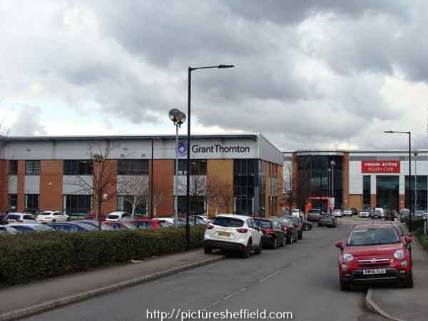
A Plan of George Hobson's Mill, Mill Dam, Weir, etc. at Heeley and of the contiguous parts of Benjamin Roebuck's Estate with description of other adjacent lands and part of Heeley, by William Fairbank. 1770. https://www.picturesheffield.com/frontend.php?keywords=Ref_No_increment;EQUALS;arc00462&pos=10&action=zoom&id=56556 Shown on the map are: River Sheaf, Little London Lane, Far Meadow, Nearer Meadow, Taylor's Grinding Wheel, Turnpike Road from Derby to Sheffield [Chesterfield Road], a Toll bar [?Heeley Toll Bar at the bottom of Albert Road] and lands of Joshua Spooner, Samuel Shore, Jonathan Wainwright, Benjamin Roebuck and William Haworth. It is believed the present day location of this area is near to 300 Broadfield Road Park, Broadfield Road, S8 0XQ. Grant Thornton, accountants and financial and management services, Unit 2 Broadfield Court showing (right) Virgin Active No.300 Broadfield Park, Broadfield Road. 2018. a04101 Photographer: Andrew Milroy.
-

Do you know my family? Swindells / Anderson / Johnson
SteveHB replied to BMJ214's topic in Sheffield Genealogy
Court 2, Harmer Lane https://maps.nls.uk/geo/explore/side-by-side/#zoom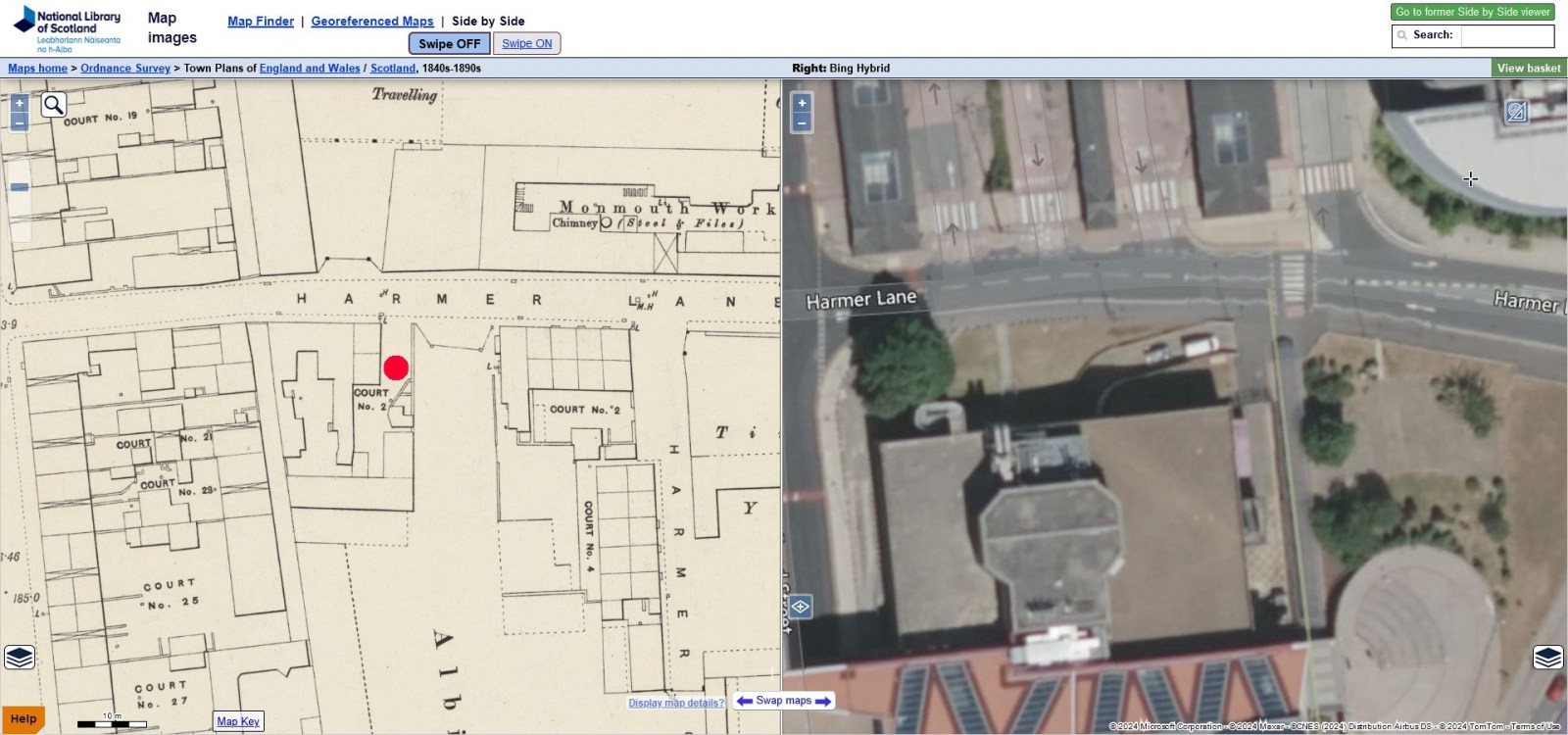
-
Do you know my family? Swindells / Anderson / Johnson
BMJ214 replied to BMJ214's topic in Sheffield Genealogy
Hi. I’m hoping someone can help me. I’ve come across a couple of addresses on Ancestry that I’m unsure about. 1. Philadelphia House, Ecclesall - 2. Tacna - 3. Harmer Lane (2 cut 1 house) 4. Fair View, Bamford Thanks in advance. -
Does anyone remember this shop on the corner of Priory Road, and Sharrow Lane?
-
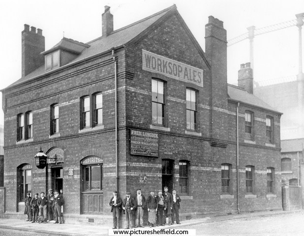
Link to: Neepsend Tavern 144 Neepsend Lane. https://www.sheffieldhistory.co.uk/forums/topic/17961-neepsend-tavern-144-neepsend-lane/
-
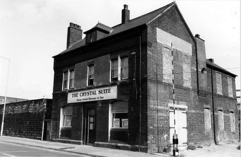
Neepsend Tavern, 144 Neepsend Lane. Worksop Ales, Fred Longden licensee. s06928 On the night of the Sheffield Flood, 11th & 22th March 1864, the Neepsend Tavern and many properties in the area were badly damaged. Extract from the "A Complete History of the Great Flood at Sheffield" "The Neepsend Tavern was partially submerged, and all the houses in Neepsend Lane were flooded to a great height. The boundary walls of the river were carried away, and many of the houses were gutted. Neepsend Bridge, built strongly of stone, sustained the shock of the Flood without giving way, but it was much shaken, and a part of the parapets of the bridge were thrown down. The stones were of immense size, and the force by which they were overturned must have been prodigious. A vast quantity of debris, timber, and furniture, was piled up against the bridge, which has formed a barrier to its further progress." The gardens (with statues and a large flagpole) and stables at the Neepsend Tavern were totally destroyed. The property including a Dram Shop, Tap Room, Bar, Brewhouse, Kitchen, Bedrooms & Cellars were badly damaged. The tenant and occupier Mary Dyson a widow, had only recently taken over the licence. (1862 Mark Dyson possibly her husband) The owners were Messrs. Joseph Garside and Daniel Fossick Alderson of Worksop, Nottinghamshire, were "Common" Brewers trading under the style of "The Prior Well Brewery Company." It appears a "Club" not named who met there, also lost property. https://sheffieldfloodclaimsarchive.shu.ac.uk/claimDetails.cfm?claim=8-6382 It's possible Mary Dyson didn't return as landlady; 1865, Joseph Deakin was the landlord recorded in directories. For further list of landlords see. Sheffield History A-Z Public Houses List. The Neepsend Tavern closed 1974, had periods of being unoccupied and converted into other uses. Brodie and Short Ltd., building contractors, formerly the Neepsend Tavern. https://www.picturesheffield.com/frontend.php?keywords=Ref_No_increment;EQUALS;t10287&pos=118&action=zoom&id=91155 The Crystal Suite, sauna, steam massage and spa, formerly Neepsend Tavern, 24th July 1985.s26222 Closed Pubs. https://www.closedpubs.co.uk/yorkshire/sheffield_s3_neepsendtavern.html Former Public House let in Neepsend. 5th August 2021. https://www.smcommercial.co.uk/former-public-house-let-in-neepsend/ Historic pub to reopen for courtyard events over Jubilee weekend. EXPOSED Magazine 1st June 2022 https://www.exposedmagazine.co.uk/archived/historical-brewery-and-pub-set-to-reopen-for-courtyard-events-over-jubilee-weekend/
-
Hi, Have just joined this group. I am looking where I can find photographs of Water Lane, Sheffield. Around the period 1870-1890. Any assistance would be most welcome.