Calvin72 Posted July 18, 2014 Share Posted July 18, 2014 Outside 131-143 Abbeydale Road there are three metal markers in the pavement with 'Peels Boundary' on them. Who or what was Peel or Peels and why did they (or he) need a boundary? Link to comment Share on other sites More sharing options...
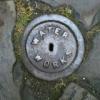
Calvin72 Posted July 18, 2014 Author Share Posted July 18, 2014 Peels Boundary marker (one of three). Link to comment Share on other sites More sharing options...
SteveHB Posted July 18, 2014 Share Posted July 18, 2014 Electoral/political area boundary? Link to comment Share on other sites More sharing options...
tozzin Posted July 19, 2014 Share Posted July 19, 2014 I think it's more a property marker, there is another one on the site under Toothills Boundary. Link to comment Share on other sites More sharing options...
SteveHB Posted July 19, 2014 Share Posted July 19, 2014 "In 1846, the parish of Sheffield was divided into 25 parochial districts, each district to have a church and incumbent to itself. Of these 25 districts, one is the vicarage of St. Peter. The others are perpetual curacies and are all provided with churches, except Dyer's hill and Gillcar. All the districts have been formed, under Peel's Act, into new ecclesiastical parishes for all useful and practical purposes." From the Directory & Topography of Sheffield, 1862, page 13 Link to comment Share on other sites More sharing options...
Calvin72 Posted July 19, 2014 Author Share Posted July 19, 2014 Interesting! I thought it was a property marker too, marking the edge between a probably substantial shop/premises and the pavement/highway. There are modern markers around doing much the same thing. However a district boundary is interesting - when was Abbeydale Road developed? I think it is old enough to come under Peel's Act, so it looks like that is the answer. However i have never seen another one - i would think that they would be more common. Link to comment Share on other sites More sharing options...
Edmund Posted July 19, 2014 Share Posted July 19, 2014 "In 1846, the parish of Sheffield was divided into 25 parochial districts, each district to have a church and incumbent to itself. Of these 25 districts, one is the vicarage of St. Peter. The others are perpetual curacies and are all provided with churches, except Dyer's hill and Gillcar. All the districts have been formed, under Peel's Act, into new ecclesiastical parishes for all useful and practical purposes." From the Directory & Topography of Sheffield, 1862, page 13 This plaque possibly dates from 1895 when the new parishes of St Barnabus Sheffield and St Andrews Sharrow were instituted. Reading the description of the boundary though, it was a little further south along Chippinghouse Road. The notice is here for anyone who wants to see the full detail: data1895.pdf data1895-2.pdf Link to comment Share on other sites More sharing options...
SteveHB Posted July 19, 2014 Share Posted July 19, 2014 This plaque possibly dates from 1895 when the new parishes of St Barnabus Sheffield and St Andrews Sharrow were instituted. Reading the description of the boundary though, it was a little further south along Chippinghouse Road. The notice is here for anyone who wants to see the full detail: data1895.pdf data1895-2.pdf Can be seen as a 'Boro Const & Ward Bdy' on the 1950's OS map #268 Link to comment Share on other sites More sharing options...
tozzin Posted July 19, 2014 Share Posted July 19, 2014 Could this "Peel" be Sir "Bobby" Peel? Link to comment Share on other sites More sharing options...

Recommended Posts
Create an account or sign in to comment
You need to be a member in order to leave a comment
Create an account
Sign up for a new account in our community. It's easy!
Register a new accountSign in
Already have an account? Sign in here.
Sign In Now